Tropical Storm FLOSSIE (CPAC): Discussions, Analysis and Ima
Moderator: S2k Moderators
-
neospaceblue
- Tropical Storm

- Posts: 112
- Age: 32
- Joined: Fri Aug 10, 2007 3:17 pm
- Location: Newport News, VA
Re: Major Hurricane Flossie in EPAC
I'm guessing that this thing will peak around the 150-165 range with a minimal central pressure in the 925-910 area.
0 likes
-
HurricaneRobert
- Category 3

- Posts: 812
- Joined: Fri May 18, 2007 9:31 pm
Re: Major Hurricane Flossie in EPAC
Do you think it will move more poleward than the official track suggests? It is far more organized than what was predicted.
0 likes

Re: Major Hurricane Flossie in EPAC
neospaceblue wrote:I'm guessing that this thing will peak around the 150-165 range with a minimal central pressure in the 925-910 area.
I don't want to call you out or anything but all four of your posts so far have been rather unscientific and over-the-top. Could you provide some evidence to suggest it will hit 165 mph?
0 likes
-
Derek Ortt
-
ncupsscweather
- Category 1

- Posts: 321
- Age: 38
- Joined: Tue Jan 02, 2007 8:05 pm
- Location: Hickory,North Carolina

-
WindRunner

- Category 5

- Posts: 5803
- Age: 35
- Joined: Fri Jul 29, 2005 8:07 pm
- Location: Warrenton, VA, but Albany, NY for school
- Contact:
Yes, the convection is the part having the problem . . . it's becoming somewhat warmer and taking on a slight elongation . . . meaning that its brief annular days are probably soon to be over. Regardless, the eye is doing well, though possibly a tiny bit colder than a few hours ago.
It also appears to be adding somewhat of a more northward component to its motion through 18Z . . . whether or not it's a long-term change is yet to be seen, but it isn't exactly good either way.
It also appears to be adding somewhat of a more northward component to its motion through 18Z . . . whether or not it's a long-term change is yet to be seen, but it isn't exactly good either way.
0 likes


Re: Major Hurricane Flossie in CPAC
I'm very surprised that Flossie pulled off category 4 strength, even going pass what the GFDL showed!!  It completely bypassed category 2 strength and then jumped to CAT4 this morning. Amazing, the forecast was completely off and RI was still occurring late this morning?
My % for CAT4 was only 25%. Annular hurricanes, got to love them.
Sixth % chance for Major Hurricane Flossie to become a:
Tropical Depression: 100%
Tropical Storm: 100%
Hurricane: 100%
Category 2 Hurricane: 100%
Category 3 Hurricane: 100%
Category 4 Hurricane: 100%
Category 5 Hurricane: 10% ~ (Mostly unknown due the fact this could cross into the Cpac and then go the "Ioke way" by small chance since it's August and that time of year)
My % for CAT4 was only 25%. Annular hurricanes, got to love them.
The following post is NOT an official forecast/product and should not be used as such. It's just the opinion of the poster and may or may not be backed by sound meteorological data. It is NOT endorsed by any professional institution or storm2k.org. For official information, please refer to the NHC and NWS products.
Sixth % chance for Major Hurricane Flossie to become a:
Tropical Depression: 100%
Tropical Storm: 100%
Hurricane: 100%
Category 2 Hurricane: 100%
Category 3 Hurricane: 100%
Category 4 Hurricane: 100%
Category 5 Hurricane: 10% ~ (Mostly unknown due the fact this could cross into the Cpac and then go the "Ioke way" by small chance since it's August and that time of year)
Last edited by Cyclenall on Sat Aug 11, 2007 2:17 pm, edited 1 time in total.
0 likes
Re:
RL3AO wrote:Saying the models and NHC completely botched this storm would be an understatement. But that goes to show that even the experts still have a lot to learn.
It's incredible, RI is basically a no science with forecasts:
First NHC Discussion of TD9-E Forecast wrote:FORECAST POSITIONS AND MAX WINDS
INITIAL 08/2100Z 13.7N 126.5W 25 KT
12HR VT 09/0600Z 13.7N 128.2W 30 KT
24HR VT 09/1800Z 13.6N 130.6W 35 KT
36HR VT 10/0600Z 13.5N 133.0W 40 KT
48HR VT 10/1800Z 13.5N 135.5W 40 KT
72HR VT 11/1800Z 14.0N 140.0W 40 KT
96HR VT 12/1800Z 15.0N 144.0W 40 KT
120HR VT 13/1800Z 16.0N 148.0W 40 KT
That's 75 knots off from the first forecast. Ouch. It's hard to believe it first formed just 70 hours ago or so. A good motto for the topics is "anything can happen" or "expect the unexpected".
0 likes


Re: Major Hurricane Flossie in CPAC
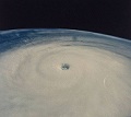
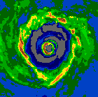
Wow, I didn't expect a Category 4 hurricane. It is a small hurricane, so it could intensify quickly as a result. 130 mph winds and 950 mb shows it is a small hurricane. Normally, 950 mb is Category 3.
0 likes
Re: Major Hurricane Flossie in CPAC
Classic stadium effect for those who noticed.
SST's go down as it progresses northwest. Near 80* where it is right now.
I guess it could hit Hawaii head-on if things change.
SST's go down as it progresses northwest. Near 80* where it is right now.
I guess it could hit Hawaii head-on if things change.
0 likes
-
HURAKAN

- Professional-Met

- Posts: 46084
- Age: 39
- Joined: Thu May 20, 2004 4:34 pm
- Location: Key West, FL
- Contact:
496
WHXX01 KMIA 111903
CHGE77
TROPICAL CYCLONE GUIDANCE MESSAGE
NWS CENTRAL PACIFIC HURRICANE CENTER HONOLULU HI
1903 UTC SAT AUG 11 2007
DISCLAIMER...NUMERICAL MODELS ARE SUBJECT TO LARGE ERRORS.
PLEASE REFER TO CPHC OFFICIAL FORECASTS FOR TROPICAL CYCLONE
AND SUBTROPICAL CYCLONE INFORMATION.
CENTRAL PACIFIC OBJECTIVE AIDS FOR
TROPICAL CYCLONE FLOSSIE (EP092007) 20070811 1800 UTC
...00 HRS... ...12 HRS... ...24 HRS. .. ...36 HRS...
070811 1800 070812 0600 070812 1800 070813 0600
LAT LON LAT LON LAT LON LAT LON
BAMS 12.9N 140.6W 13.2N 142.6W 13.3N 144.9W 13.8N 147.4W
BAMD 12.9N 140.6W 13.4N 143.1W 13.8N 145.4W 14.4N 147.5W
BAMM 12.9N 140.6W 13.2N 143.0W 13.3N 145.2W 13.6N 147.5W
LBAR 12.9N 140.6W 13.6N 142.6W 14.4N 144.8W 15.3N 146.5W
SHIP 115KTS 112KTS 103KTS 93KTS
DSHP 115KTS 112KTS 103KTS 93KTS
...48 HRS... ...72 HRS... ...96 HRS. .. ..120 HRS...
070813 1800 070814 1800 070815 1800 070816 1800
LAT LON LAT LON LAT LON LAT LON
BAMS 14.5N 149.7W 16.0N 153.8W 16.9N 157.7W 17.5N 161.5W
BAMD 15.2N 149.8W 17.7N 152.7W 20.4N 153.0W 22.5N 151.5W
BAMM 14.1N 149.9W 15.2N 153.8W 16.0N 156.8W 16.4N 159.7W
LBAR 16.5N 147.9W 18.9N 150.1W 21.2N 150.9W 23.7N 150.3W
SHIP 83KTS 65KTS 52KTS 44KTS
DSHP 83KTS 65KTS 52KTS 44KTS
...INITIAL CONDITIONS...
LATCUR = 12.9N LONCUR = 140.6W DIRCUR = 275DEG SPDCUR = 9KT
LATM12 = 12.6N LONM12 = 138.7W DIRM12 = 273DEG SPDM12 = 10KT
LATM24 = 12.6N LONM24 = 136.6W
WNDCUR = 115KT RMAXWD = 15NM WNDM12 = 100KT
CENPRS = 949MB OUTPRS = 1010MB OUTRAD = 175NM SDEPTH = D
RD34NE = 75NM RD34SE = 60NM RD34SW = 60NM RD34NW = 75NM
$$
NNNN
950
WHXX01 KMIA 111915
CHGE77
TROPICAL CYCLONE GUIDANCE MESSAGE
NWS CENTRAL PACIFIC HURRICANE CENTER HONOLULU HI
1915 UTC SAT AUG 11 2007
DISCLAIMER...NUMERICAL MODELS ARE SUBJECT TO LARGE ERRORS.
PLEASE REFER TO CPHC OFFICIAL FORECASTS FOR TROPICAL CYCLONE
AND SUBTROPICAL CYCLONE INFORMATION.
CENTRAL PACIFIC OBJECTIVE AIDS FOR
TROPICAL CYCLONE FLOSSIE (EP092007) 20070811 1800 UTC
...00 HRS... ...12 HRS... ...24 HRS. .. ...36 HRS...
070811 1800 070812 0600 070812 1800 070813 0600
LAT LON LAT LON LAT LON LAT LON
BAMS 12.9N 140.6W 13.2N 142.6W 13.3N 144.9W 13.8N 147.4W
BAMD 12.9N 140.6W 13.4N 143.1W 13.8N 145.4W 14.4N 147.5W
BAMM 12.9N 140.6W 13.2N 143.0W 13.3N 145.2W 13.6N 147.5W
LBAR 12.9N 140.6W 13.6N 142.6W 14.4N 144.8W 15.3N 146.5W
SHIP 115KTS 112KTS 102KTS 91KTS
DSHP 115KTS 112KTS 102KTS 91KTS
...48 HRS... ...72 HRS... ...96 HRS. .. ..120 HRS...
070813 1800 070814 1800 070815 1800 070816 1800
LAT LON LAT LON LAT LON LAT LON
BAMS 14.5N 149.7W 16.0N 153.8W 16.9N 157.7W 17.5N 161.5W
BAMD 15.2N 149.8W 17.7N 152.7W 20.4N 153.0W 22.5N 151.5W
BAMM 14.1N 149.9W 15.2N 153.8W 16.0N 156.8W 16.4N 159.7W
LBAR 16.5N 147.9W 18.9N 150.1W 21.2N 150.9W 23.7N 150.3W
SHIP 81KTS 61KTS 48KTS 38KTS
DSHP 81KTS 61KTS 48KTS 38KTS
...INITIAL CONDITIONS...
LATCUR = 12.9N LONCUR = 140.6W DIRCUR = 275DEG SPDCUR = 9KT
LATM12 = 12.6N LONM12 = 138.7W DIRM12 = 273DEG SPDM12 = 10KT
LATM24 = 12.6N LONM24 = 136.6W
WNDCUR = 115KT RMAXWD = 15NM WNDM12 = 100KT
CENPRS = 949MB OUTPRS = 1010MB OUTRAD = 175NM SDEPTH = D
RD34NE = 75NM RD34SE = 60NM RD34SW = 60NM RD34NW = 75NM
0 likes
-
eye-land girl
- Tropical Wave

- Posts: 1
- Joined: Sat Aug 11, 2007 2:07 pm
- Location: Oahu, Hawaii
If you lived in Hawaii, would you be nervous right now?
I'm over here on Oahu trying to decide how worried I should be. The newscasts always downplay every storm that approaches until it's too late for us to prepare. For instance, with Iniki, the last news broadcast of the night put us all to bed thinking we were in the clear and then we were startled in the middle of the night by sirens warning of our impending danger. We had very little time to prepare as most stores were either closed or closing early the next day. Fortunately the island of Oahu didn't take a direct hit, but Kauai was devastated, as you all know.
I know it's best to be prepared, and we do have the basics, but if you were me would you be rushing out to get batteries, bottled water, etc?
Thanks for any help you can provide!
0 likes
-
Derek Ortt
-
CrazyC83
- Professional-Met
- Posts: 34316
- Joined: Tue Mar 07, 2006 11:57 pm
- Location: Deep South, for the first time!
Re:
eye-land girl wrote:If you lived in Hawaii, would you be nervous right now?
I'm over here on Oahu trying to decide how worried I should be. The newscasts always downplay every storm that approaches until it's too late for us to prepare. For instance, with Iniki, the last news broadcast of the night put us all to bed thinking we were in the clear and then we were startled in the middle of the night by sirens warning of our impending danger. We had very little time to prepare as most stores were either closed or closing early the next day. Fortunately the island of Oahu didn't take a direct hit, but Kauai was devastated, as you all know.
I know it's best to be prepared, and we do have the basics, but if you were me would you be rushing out to get batteries, bottled water, etc?
Thanks for any help you can provide!
Yes I would before the rush. Supplies can be scarce once you have a hurricane on your doorstep...
0 likes
Who is online
Users browsing this forum: No registered users and 11 guests