Typhoon Man-yi (04W)

Moderator: S2k Moderators

Message
Author
CrazyC83
Professional-Met
Professional-Met
Posts: 33398
Joined: Tue Mar 07, 2006 11:57 pm
Location: Deep South, for the first time!

Re: Typhoon Man-yi (04W)

#181 Postby CrazyC83 » Thu Jul 12, 2007 4:10 pm

miamicanes177 wrote:Just in...135kts sustained with gusts to 165kts. That is gusting to 190mph!!!!!! Holy crap that is strong.


In the Western Pacific, that is quite routine.
0 likes   

User avatar
cycloneye
Admin
Admin
Posts: 139598
Age: 67
Joined: Thu Oct 10, 2002 10:54 am
Location: San Juan, Puerto Rico

Re: Super-Typhoon Man-yi (04W)

#182 Postby cycloneye » Thu Jul 12, 2007 4:14 pm

P.K. wrote:Luis there is no such thing as a "super-typhoon" officially. :wink:

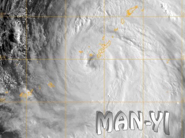
Still at 95kts (930hPa).

RSMC TROPICAL CYCLONE ADVISORY
NAME TY 0704 MAN-YI (0704)
ANALYSIS
PSTN 121800UTC 24.9N 127.5E GOOD
MOVE NNW 12KT
PRES 930HPA
MXWD 095KT
GUST 135KT
50KT 170NM NORTHEAST 100NM SOUTHWEST
30KT 350NM EAST 280NM WEST
FORECAST
24HF 131800UTC 29.1N 128.3E 100NM 70%
MOVE NNE 11KT
PRES 940HPA
MXWD 085KT
GUST 120KT
48HF 141800UTC 33.4N 134.9E 170NM 70%
MOVE NE 18KT
PRES 965HPA
MXWD 070KT
GUST 100KT
72HF 151800UTC 35.9N 142.2E 270NM 70%
MOVE ENE 16KT
PRES 975HPA
MXWD 060KT
GUST 085KT


Grrr those agencies and their different intensity forecasts.
0 likes   

User avatar
windstorm99
S2K Supporter
S2K Supporter
Posts: 1578
Age: 46
Joined: Sat May 26, 2007 8:10 am
Location: Miami, Florida
Contact:

Re: Typhoon Man-yi (04W)

#183 Postby windstorm99 » Thu Jul 12, 2007 5:18 pm

Image
0 likes   

User avatar
HURAKAN
Professional-Met
Professional-Met
Posts: 46086
Age: 37
Joined: Thu May 20, 2004 4:34 pm
Location: Key West, FL
Contact:

#184 Postby HURAKAN » Thu Jul 12, 2007 6:31 pm

Image

THE WORSE PART OF THE STORM IS HAPPENING AS WE SPEAK.
0 likes   

User avatar
wxmann_91
Category 5
Category 5
Posts: 8013
Age: 33
Joined: Fri Jul 15, 2005 2:49 pm
Location: Southern California
Contact:

Re: Re:

#185 Postby wxmann_91 » Thu Jul 12, 2007 6:35 pm

If anything, IMO, the intensity of this system should've been lowered, not raised. The western part of the storm is completely eaten away.

miamicanes177 wrote:
Derek Ortt wrote:looks like shear is starting to impinge upon this system

I'd look from weakening from ehre on out and would wager anything that this does not strike japan as a cat 3. Not sure why JTWC always forecasts these strong systems to hit japan as a 3, when they always weaken rapidly before landfall
I'm taking you up on this bet. I forecast this to make landfall as a major hurricane. The loser admits he was wrong.

Need some more specifics. How about the loser posts a thread in which he admits that his forecast was completely wrong and the other man had the forecast right. That way it doesn't get lost among the shuffles within a thread.
0 likes   

User avatar
cycloneye
Admin
Admin
Posts: 139598
Age: 67
Joined: Thu Oct 10, 2002 10:54 am
Location: San Juan, Puerto Rico

#186 Postby cycloneye » Thu Jul 12, 2007 6:35 pm

Okinawa is getting the eastern eyewall now.Let's hope that there are no tragic news from there.
0 likes   

HurricaneBill
Category 5
Category 5
Posts: 3420
Joined: Sun Apr 11, 2004 5:51 pm
Location: East Longmeadow, MA, USA

Re:

#187 Postby HurricaneBill » Thu Jul 12, 2007 6:54 pm

cycloneye wrote:Okinawa is getting the eastern eyewall now.Let's hope that there are no tragic news from there.


Indeed. Okinawa has experienced tragedy due to typhoons in the past. In 1956, 11 U.S. Marines drowned in a rip current produced by Super Typhoon Emma as it was heading towards Okinawa.
0 likes   

User avatar
Chacor
Category 5
Category 5
Posts: 10229
Joined: Mon Oct 02, 2006 10:43 pm
Location: Singapore

#188 Postby Chacor » Thu Jul 12, 2007 6:56 pm

Futenma
Wind from the E (100 degrees) at 55 MPH (48 KT) gusting to 87 MPH (76 KT)

Naha
Wind from the ESE (120 degrees) at 55 MPH (48 KT) gusting to 93 MPH (81 KT) (direction variable)

Kadena AB
Wind from the E (100 degrees) at 60 MPH (52 KT) gusting to 79 MPH (69 KT) (direction variable)
0 likes   

wehrkampjr_21
Tropical Wave
Tropical Wave
Posts: 2
Age: 41
Joined: Thu Jul 12, 2007 8:24 am
Location: Okinawa, Japan

Re: Typhoon Man-yi (04W)

#189 Postby wehrkampjr_21 » Thu Jul 12, 2007 6:58 pm

It's 9am here now. The wind and rain have really picked up from last night. It seems to be getting stronger by the minute. Some of the trees have started to lose branches and two of the Jeeps in our parking lot are really starting to sway back and forth. Other than that, no other damage to report, as least from the part of the island we are located. Keep you updated..
0 likes   

HurricaneBill
Category 5
Category 5
Posts: 3420
Joined: Sun Apr 11, 2004 5:51 pm
Location: East Longmeadow, MA, USA

Re: Re:

#190 Postby HurricaneBill » Thu Jul 12, 2007 6:59 pm

wxmann_91 wrote:Need some more specifics. How about the loser posts a thread in which he admits that his forecast was completely wrong and the other man had the forecast right. That way it doesn't get lost among the shuffles within a thread.


Regardless of Man-Yi's intensity at landfall, this could cause a lot of damage in Japan if Man-Yi takes its forcasted path.
0 likes   

User avatar
Chacor
Category 5
Category 5
Posts: 10229
Joined: Mon Oct 02, 2006 10:43 pm
Location: Singapore

Re: Re:

#191 Postby Chacor » Thu Jul 12, 2007 7:01 pm

HurricaneBill wrote:
wxmann_91 wrote:Need some more specifics. How about the loser posts a thread in which he admits that his forecast was completely wrong and the other man had the forecast right. That way it doesn't get lost among the shuffles within a thread.


Regardless of Man-Yi's intensity at landfall, this could cause a lot of damage in Japan if Man-Yi takes its forcasted path.


If the JTWC is right with XT-trans it will be slightly better (since winds won't actually be consolidated near the centre) and it'll be just another wind storm to the Japanese...
0 likes   

MiamiensisWx

Re: Typhoon Man-yi (04W)

#192 Postby MiamiensisWx » Thu Jul 12, 2007 7:18 pm

The pressure has decreased to 940 mbar at Naha Airport, but the winds have not exceeded 60 kts (1-min). The pressure reading is unimpressive, especially because of the fact that this storm is located over the western Pacific (weaker background pressures). Personally, I do not believe JTWC's estimates. The JMA's estimates were too generous (10-min). This storm never exceeded 120 kts (1-min). Since Okinawa's elevation is variable, Naha may be sheltered from the maximum winds which may occur over exposed locations. The eyewall is moving over the vicinity...
0 likes   

User avatar
windstorm99
S2K Supporter
S2K Supporter
Posts: 1578
Age: 46
Joined: Sat May 26, 2007 8:10 am
Location: Miami, Florida
Contact:

Re: Typhoon Man-yi (04W)

#193 Postby windstorm99 » Thu Jul 12, 2007 7:45 pm

Here an awsome view from the Aqua Satelitte.

Image
0 likes   

User avatar
cycloneye
Admin
Admin
Posts: 139598
Age: 67
Joined: Thu Oct 10, 2002 10:54 am
Location: San Juan, Puerto Rico

Re: Typhoon Man-yi (04W)

#194 Postby cycloneye » Thu Jul 12, 2007 7:54 pm

TY 0704 (MAN-YI)
Issued at 00:00 UTC, 13 July 2007RSMC TROPICAL CYCLONE ADVISORY
NAME TY 0704 MAN-YI (0704)

ANALYSIS
PSTN 130000UTC 26.0N 127.4E GOOD
MOVE N 11KT
PRES 930HPA
MXWD 095KT
GUST 135KT
50KT 200NM EAST 100NM WEST
30KT 325NM EAST 280NM WEST

FORECAST
24HF 140000UTC 30.4N 129.5E 100NM 70%
MOVE NE 14KT
PRES 945HPA
MXWD 080KT
GUST 115KT
48HF 150000UTC 34.5N 137.6E 170NM 70%
MOVE ENE 20KT
PRES 970HPA
MXWD 065KT
GUST 095KT
72HF 160000UTC 36.8N 143.7E 270NM 70%
MOVE ENE 14KT
PRES 985HPA
MXWD 050KT
GUST 070KT
0 likes   

User avatar
KatDaddy
Category 5
Category 5
Posts: 2815
Joined: Mon Oct 21, 2002 6:23 pm
Location: League City, Texas

Re: Typhoon Man-yi (04W)

#195 Postby KatDaddy » Thu Jul 12, 2007 8:05 pm

Naha Airport is in the eastern eye. Winds S-29MPH


Conditions at Jul 12, 2007 - 08:44 PM EDTJul 12, 2007 - 07:44 PM CDTJul 12, 2007 - 06:44 PM MDTJul 12, 2007 - 05:44 PM PDTJul 12, 2007 - 04:44 PM ADTJul 12, 2007 - 03:44 PM HDT
2007.07.13 0044 UTC
Wind from the S (190 degrees) at 29 MPH (25 KT) (direction variable)
Visibility 1 mile(s)
Sky conditions mostly cloudy
Weather Light rain showers
Mist
Cumulonimbus clouds observed
Temperature 82 F (28 C)
Dew Point 80 F (27 C)
Relative Humidity 94%
Pressure (altimeter) 27.76 in. Hg (0940 hPa)
ob ROAH 130044Z 19025KT 2000 R36/1000V1500N -SHRA BR SCT006 BKN010 FEW020CB 28/27 Q0940 RMK 3ST006 5CU010 2CB020 A2778 CB 15KM E-SE MOV NW

--------------------------------------------------------------------------------
0 likes   

User avatar
windstorm99
S2K Supporter
S2K Supporter
Posts: 1578
Age: 46
Joined: Sat May 26, 2007 8:10 am
Location: Miami, Florida
Contact:

Re: Typhoon Man-yi (04W)

#196 Postby windstorm99 » Thu Jul 12, 2007 8:27 pm

For those interested in seeing an absolutely awsome radar shot and loop of MAN-YI making landfall see this link.Make sure you zoom in.

Okinawa radar

Image
0 likes   

User avatar
Ptarmigan
Category 5
Category 5
Posts: 5273
Joined: Wed Aug 16, 2006 9:06 pm

Re: Typhoon Man-yi (04W)

#197 Postby Ptarmigan » Thu Jul 12, 2007 8:44 pm

My prediction of Man-yi becoming a Category 5 have come true. :eek: :cry:
0 likes   

User avatar
Chacor
Category 5
Category 5
Posts: 10229
Joined: Mon Oct 02, 2006 10:43 pm
Location: Singapore

Re: Typhoon Man-yi (04W)

#198 Postby Chacor » Thu Jul 12, 2007 8:49 pm

Ptarmigan wrote:My prediction of Man-yi becoming a Category 5 have come true. :eek: :cry:


Not quite. Cat 5 = 140 kts. NRL now has Man-yi back to 125 kt, down from 135. Very close to Naha now.
0 likes   

User avatar
Chacor
Category 5
Category 5
Posts: 10229
Joined: Mon Oct 02, 2006 10:43 pm
Location: Singapore

#199 Postby Chacor » Thu Jul 12, 2007 8:56 pm

Here's the JMA's 01Z update:

<13日10時の実況>
大きさ 大型
強さ 非常に強い
存在地域 那覇市の付近
Current position: Vicinity of Naha City
中心位置 北緯 26度10分(26.2度)
東経 127度30分(127.5度)
進行方向、速さ 北 20km/h(11kt)
中心気圧 930hPa
中心付近の最大風速 50m/s(95kt)
最大瞬間風速 70m/s(135kt)
25m/s以上の暴風域 東側 370km(200NM)
西側 190km(100NM)
15m/s以上の強風域 東側 600km(325NM)
西側 520km(280NM)
0 likes   

User avatar
Chacor
Category 5
Category 5
Posts: 10229
Joined: Mon Oct 02, 2006 10:43 pm
Location: Singapore

#200 Postby Chacor » Thu Jul 12, 2007 9:07 pm

Wind from the SW (220 degrees) at 70 MPH (61 KT) gusting to 85 MPH (74 KT) (direction variable)

Naha getting very close to typhoon-force sustained winds...
0 likes   


Return to “2007”

Who is online

Users browsing this forum: No registered users and 6 guests