Hurricane FELIX: Caribbean-Discussions
Moderator: S2k Moderators
-
Coredesat
Re:
O Town wrote:Why? Why is there no recon in there for landfall?
Anybody know the reason why they cancelled?
If there isn't a flight scheduled, they can't be there. Recon was only in Dean during landfall because it happened to be landfalling at the time the mission was scheduled.
0 likes


Re: Re:
miamicanes177 wrote:You are correct. Its ability to transfer flight level winds to the surface is shocking. Conversion factor is nearly 100% for this beast.Normandy wrote:Heh 160 might be conservative....this looks as intense as any small hurricane I have EVER seen. The convection in it is just UNREAL.
Well we don't know that for SURE, but looking at past canes that rapidly deepened until landfall, usually the conversion level is rather high.
Hurricane Andrew had flight level winds of 162 kts, and HURDAT analyzes Andrew as a 153 kt cane at landfall...indicating a conversion factor greater than .9
Hurricane Dean had flight level winds of 166 kts and data supported winds in Dean anywhere from 140-160 kts....indicating a conversion factor greater than .9
Felix is similar to both, as it has intense convection and a warming eye.
EDIT:
And superfly yes, I've seen Wilma at her peak. THAT is how good I think Felix looks right now.
0 likes
-
Matt-hurricanewatcher
Re: Hurricane FELIX:Caribbean-Discussions & Imagery 5 AM pag 77
That is why I don't state Wilma. Because wilma was mind blowing, but it never made landfall with any where near its peak.
Maybe Allen 1980 should be added to my list of systems felix could come close in wind.
Maybe Allen 1980 should be added to my list of systems felix could come close in wind.
0 likes
-
Coredesat
Re:
Coredesat wrote:Also, the convection here isn't exactly that deep; Wilma had deeper convection (yellows on the NRL IR channel), and of course Sepat in the WPAC. Felix had some yellows earlier on, I think, but I can't be sure about that.
Its all relative...
Felix has some pretty intense Convection...prolly just as intense as Dean had. Adittionally, convection around the eye itself has never been more intense in Felix's lifetime...
Seeing what happened last time Felix looked this good, I'd assume some pretty scary winds are occuring at the surface.
0 likes


Re: Re:
superfly wrote:Normandy wrote:EDIT:
And superfly yes, I've seen Wilma at her peak. THAT is how good I think Felix looks right now.
Then you really need to tone down the sensationalism. The two aren't even comparable.
Felix:
Wilma:
No sensationalism.
I said Felix is one of the best looking small hurricanes I have ever seen... Are you really going to argue with me on that point?
0 likes
-
Matt-hurricanewatcher
Re: Hurricane FELIX:Caribbean-Discussions & Imagery 5 AM pag 77
Mitch had blacks its been a long time...I can't believe how the years fly pass.
0 likes


Re: Re:
superfly wrote:Normandy wrote:No sensationalism.
I said Felix is one of the best looking small hurricanes I have ever seen... Are you really going to argue with me on that point?
No, you did not say that. You said it's as intense as any small hurricane you've ever seen, which it is not.
Again, lets look at Felix's history:
- Sonde measured 160 kt surface winds
- Turbulence forced Recon to abandon its mission
Now, considering that it looks MORE intense than it did then, what makes it so hard to believe that it has winds similar to Wilma? Wilma at her peak had 175 mph winds correct? or was it 185? i can't remember.
And also, Wilma NEVER chased the recon crew away due to turblence....just something to ponder. Really im not going to argue this with you, were just getting off topic...
Point is a devastating hurricane is striking Nicaragua.
Last edited by Normandy on Tue Sep 04, 2007 6:04 am, edited 1 time in total.
0 likes

-
Coredesat
Re: Re:
Normandy wrote:Again, lets look at Felix's history:
- Sonde measured 160 kt surface winds
- Turbulence forced Recon to abandon its mission
Now, considering that it looks MORE intense than it did then, what makes it so hard to believe that it has winds similar to Wilma? Wilma at her peak had 175 mph winds correct? or was it 185? i can't remember.
And also, Wilma NEVER chased the recon crew away due to turblence....just something to ponder. Really im not going to argue this with you, were just getting off topic...
Point is a devastating hurricane is striking Nicaragua.
That wasn't a dropsonde, that was a graupel-inflated SFMR measurement. It doesn't look more intense now than it did then; right now it looks like there is upper-level dry air entrainment in the NW quad.
0 likes
-
flamingosun

- S2K Supporter

- Posts: 197
- Joined: Wed Sep 15, 2004 4:51 am
- Location: Merritt Island, FL
Re: Hurricane FELIX:Caribbean-Discussions & Imagery 5 AM pag 77
000
WTNT61 KNHC 041040
TCUAT1
HURRICANE FELIX TROPICAL CYCLONE UPDATE
NWS TPC/NATIONAL HURRICANE CENTER MIAMI FL AL062007
640 AM AST TUE SEP 04 2007
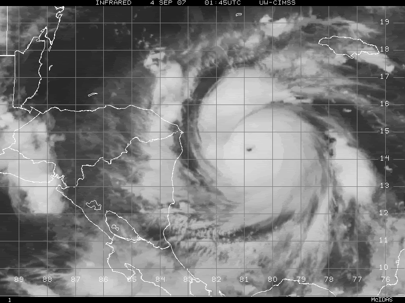
SATELLITE IMAGERY INDICATES THAT HURRICANE FELIX HAS CONTINUED TO
STRENGTHEN...AND HAS BECOME A POTENTIALLY CATASTROPHIC CATEGORY
FIVE HURRICANE WITH MAXIMUM SUSTAINED WINDS OF 160 MPH...260
KM/HR...JUST OFF THE COAST OF NORTHEASTERN NICARAGUA.
$$
FORECASTER KNABB
WTNT61 KNHC 041040
TCUAT1
HURRICANE FELIX TROPICAL CYCLONE UPDATE
NWS TPC/NATIONAL HURRICANE CENTER MIAMI FL AL062007
640 AM AST TUE SEP 04 2007
SATELLITE IMAGERY INDICATES THAT HURRICANE FELIX HAS CONTINUED TO
STRENGTHEN...AND HAS BECOME A POTENTIALLY CATASTROPHIC CATEGORY
FIVE HURRICANE WITH MAXIMUM SUSTAINED WINDS OF 160 MPH...260
KM/HR...JUST OFF THE COAST OF NORTHEASTERN NICARAGUA.
$$
FORECASTER KNABB
0 likes
Re: Re:
Coredesat wrote:Normandy wrote:Again, lets look at Felix's history:
- Sonde measured 160 kt surface winds
- Turbulence forced Recon to abandon its mission
Now, considering that it looks MORE intense than it did then, what makes it so hard to believe that it has winds similar to Wilma? Wilma at her peak had 175 mph winds correct? or was it 185? i can't remember.
And also, Wilma NEVER chased the recon crew away due to turblence....just something to ponder. Really im not going to argue this with you, were just getting off topic...
Point is a devastating hurricane is striking Nicaragua.
That wasn't a dropsonde, that was a graupel-inflated SFMR measurement. It doesn't look more intense now than it did then; right now it looks like there is upper-level dry air entrainment in the NW quad.
Dry air entrainment? Well....sure hasn't stopped it from deepening it seems. And yes, imo it does look more intense now than it did then....but we can agree to disagree.
And thanks for the dropsonde correction.
0 likes
Re: Re:
Coredesat wrote:Normandy wrote:Dry air entrainment? Well....sure hasn't stopped it from deepening it seems. And yes, imo it does look more intense now than it did then....but we can agree to disagree.
True, no sense in arguing when a Category 5 is crossing the coast...again.
Isn't that just astounding? The fact that not one, but TWO Category 5's (And deepening ones at that) strike land in the same season?
Also of note....Each hurricane this season has not only become a major, but a landfalling Cat5. Pretty rare and amazing season, and almost as unreal as 2005 and 2004 in some regards so far.
0 likes
Who is online
Users browsing this forum: No registered users and 31 guests