TD INGRID: Discussions & Images - Last Advisory

Moderator: S2k Moderators

Message
Author
destruction92
Category 1
Category 1
Posts: 312
Joined: Sun Jul 22, 2007 10:43 pm

Re: Re:

#141 Postby destruction92 » Sun Sep 09, 2007 10:34 pm

ROCK wrote:
destruction92 wrote:
Extremeweatherguy wrote:Out of the 3 invests, I think this one has the most long-term potential. I also do not think this system will recurve. The ridge looks too strong and the system is far enough south that I think another caribbean storm is very possible. We will have to see what happens..


The subtropical ridge is not going to be that strong to make another hurricane the talk of the Caribbean and GOM. In the short term, a weak trough in the central Atlantic should steer 91L wnw until the ridge builds back. This may enter the extreme northern Caribbean for a short time as it threatens the northern Leeward Islands and possibly Puerto Rico.

Right now, I think the safest bet is to take the middle path between the fish scenario and the "it's going to the Caribbean (silently implied GOM)" scenario.


And what are you implying? You know I am getting tired of your act. Know where in EWG's post did he imply anything. Are you a mind reader?

Try backing your argument with some sound data. The GDFL hasn't even run on this system yet. The BAMMS keep it shallow. Did you look at the latest GFS run? The high is forecasted to be strong.....As strong as Felix and Dean probably not but for the next few days its westward- WNW. By that time it will have organized enough for the globals to intialize it better as far as track....

Again I ask what is your issue?


Getting back on topic, 91L is probably going to be a depression (issues or no issues :lol: ).
With the synoptic pattern changing and cold fronts appearing farther south along the east coast with more frequency, I would say that 91L's threat region is from the central gulf coast to the Carolinas.

Even if 91L makes it far enough west in the Caribbean, an Ivan or Charley scenario seems plausible if another strong cold front approaches the Southeast like Tampa NWS and other long range forecasts have suggested. Central America, Mexico, Texas, and New England seem unlikely IMO for having to deal with 91L.
0 likes   

jaxfladude
Category 5
Category 5
Posts: 1249
Joined: Wed Aug 24, 2005 9:36 pm
Location: Jacksonville, Fla

Re: Invest 91L,East Atlantic-Discussions & Images

#142 Postby jaxfladude » Sun Sep 09, 2007 10:41 pm

Three Invests and all 3 are playing with us.....make up your minds Invests and be done with it.. :talk to the hand:
0 likes   

Matt-hurricanewatcher

Re: Invest 91L,East Atlantic-Discussions & Images

#143 Postby Matt-hurricanewatcher » Sun Sep 09, 2007 10:43 pm

I would put my money on this system,,,92L would take days to form a LLC at the surface. 90L has to deal with the super unfavorable gulf of Mexico, it would not blow me away if a weak system where to form before it made landfall.

91L is developing in the area that the strong systems this season have developed. That is on the base of the subtropical ridge. I expect it has to deal with some shear and sal for the next 24 hours. Once pass 40 west, I think this should slowly become more organized.
0 likes   

User avatar
ROCK
Category 5
Category 5
Posts: 9484
Age: 54
Joined: Tue Aug 17, 2004 7:30 am
Location: Kemah, Texas

Re: Invest 91L,East Atlantic-Discussions & Images

#144 Postby ROCK » Sun Sep 09, 2007 10:45 pm

Ok that is much better... :D I have been around this board a long time and have seen a lot of every kind of forcasting / -removed- / dreamcasting you can think of. In our efforts to keep things civil in here, we restrain oursleves from accusing fellow posters of all of the above. There is no need for it and should not be tolerated.

but on topic- 91L has a good chance at the carib IMO. I know all about the fronts progged this week and next weekend. And your right they could be a factor. Ableit the latter might. Tuesdays front won't even make it to the coast.

Its all about timing in Sept. You miss a trough and wnw bound with a building high.
0 likes   

User avatar
MGC
S2K Supporter
S2K Supporter
Posts: 5899
Joined: Sun Mar 23, 2003 9:05 pm
Location: Pass Christian MS, or what is left.

Re: Invest 91L,East Atlantic-Discussions & Images

#145 Postby MGC » Sun Sep 09, 2007 11:40 pm

91L appears to have a excellent chance to become a named TC. It appears to have a MLC and convection is starting to band. Looks to be heading beween W and WNW. 91L could pose a risk to the northern islands in a few days. It has the look....MGC
0 likes   

User avatar
HURAKAN
Professional-Met
Professional-Met
Posts: 46086
Age: 38
Joined: Thu May 20, 2004 4:34 pm
Location: Key West, FL
Contact:

#146 Postby HURAKAN » Sun Sep 09, 2007 11:55 pm

Latest:

Image

The morning should provide a better view of 91L.
0 likes   

User avatar
Typhoon_Willie
Category 5
Category 5
Posts: 1042
Joined: Mon Jun 09, 2003 3:19 pm
Location: Greenacres City, Florida

Re: Invest 91L,East Atlantic-Discussions & Images

#147 Postby Typhoon_Willie » Mon Sep 10, 2007 2:40 am

Here is the latest wide angle loop of the Atlantic showing 91L's convection has increased quite a bit!
0 likes   

User avatar
Meso
Category 5
Category 5
Posts: 1609
Age: 38
Joined: Mon Aug 09, 2004 12:14 pm
Location: South Africa
Contact:

#148 Postby Meso » Mon Sep 10, 2007 4:29 am

A BROAD AREA OF LOW PRESSURE...ASSOCIATED WITH A TROPICAL WAVE...IS
LOCATED ABOUT 900 MILES WEST-SOUTHWEST OF THE CAPE VERDE ISLANDS
AND IS PRODUCING A LARGE AREA OF CLOUDINESS AND THUNDERSTORMS. THIS
SYSTEM IS GRADUALLY BECOMING BETTER ORGANIZED AND HAS THE POTENTIAL
TO DEVELOP INTO A TROPICAL DEPRESSION DURING THE NEXT COUPLE OF
DAYS AS IT MOVES WESTWARD TO WEST-NORTHWESTWARD AT 10-15 MPH.


$$

FORECASTER RHOME
0 likes   

User avatar
HURAKAN
Professional-Met
Professional-Met
Posts: 46086
Age: 38
Joined: Thu May 20, 2004 4:34 pm
Location: Key West, FL
Contact:

#149 Postby HURAKAN » Mon Sep 10, 2007 4:30 am

Latest:

Image
0 likes   

User avatar
wxman57
Moderator-Pro Met
Moderator-Pro Met
Posts: 22978
Age: 67
Joined: Sat Jun 21, 2003 8:06 pm
Location: Houston, TX (southwest)

Re: Invest 91L,East Atlantic-Discussions & Images

#150 Postby wxman57 » Mon Sep 10, 2007 4:48 am

Now this one looks like it could be trouble down the road. But even though it's the only disturbance in the tropics that comes close to being invest-worthy, it has a better chance of dissipating than developing. Just a strong wave to keep an eye on for now. High pressure north of it is fairly weak, which could result in a WNW track that might lift it north of the Caribbean (if it develops).
0 likes   

User avatar
HURAKAN
Professional-Met
Professional-Met
Posts: 46086
Age: 38
Joined: Thu May 20, 2004 4:34 pm
Location: Key West, FL
Contact:

#151 Postby HURAKAN » Mon Sep 10, 2007 5:00 am

Latest:

Image
0 likes   

User avatar
Thunder44
Category 5
Category 5
Posts: 5922
Age: 44
Joined: Mon Jun 09, 2003 7:53 pm
Location: New York City

Re: Invest 91L,East Atlantic-Discussions & Images

#152 Postby Thunder44 » Mon Sep 10, 2007 5:06 am

Whatever low-level circulation exists here, looks very broad or elongated. I do think it can develop over the next few days though.
0 likes   

User avatar
Typhoon_Willie
Category 5
Category 5
Posts: 1042
Joined: Mon Jun 09, 2003 3:19 pm
Location: Greenacres City, Florida

Re: Invest 91L,East Atlantic-Discussions & Images

#153 Postby Typhoon_Willie » Mon Sep 10, 2007 5:18 am

Correct me if I am wrong but is the system beginning to set up both poleward and equatorial outflow channels? I do notice the feathering look so to speak.
0 likes   

User avatar
HURAKAN
Professional-Met
Professional-Met
Posts: 46086
Age: 38
Joined: Thu May 20, 2004 4:34 pm
Location: Key West, FL
Contact:

#154 Postby HURAKAN » Mon Sep 10, 2007 5:27 am

Latest:

Image
0 likes   

Matt-hurricanewatcher

Re: Invest 91L,East Atlantic-Discussions & Images

#155 Postby Matt-hurricanewatcher » Mon Sep 10, 2007 5:28 am

Looks much more organized then Gabrielle, that is for darn sure.
0 likes   

User avatar
HURAKAN
Professional-Met
Professional-Met
Posts: 46086
Age: 38
Joined: Thu May 20, 2004 4:34 pm
Location: Key West, FL
Contact:

Re: Invest 91L,East Atlantic-Discussions & Images

#156 Postby HURAKAN » Mon Sep 10, 2007 5:32 am

Matt-hurricanewatcher wrote:Looks much more organized then Gabrielle, that is for darn sure.


2007's Tropic of Cancer Rule:

Above: Insignificant TS/STS.

Below: Pure Monsters.
0 likes   

User avatar
HurricaneMaster_PR
Category 2
Category 2
Posts: 795
Joined: Tue Jul 22, 2003 6:23 pm
Location: San Juan, Puerto Rico

Re: Invest 91L,East Atlantic-Discussions & Images

#157 Postby HurricaneMaster_PR » Mon Sep 10, 2007 5:36 am

DATE/TIME LAT LON CLASSIFICATION STORM
10/0645 UTC 9.9N 39.0W T1.0/1.0 91L
0 likes   

User avatar
HurricaneMaster_PR
Category 2
Category 2
Posts: 795
Joined: Tue Jul 22, 2003 6:23 pm
Location: San Juan, Puerto Rico

Re: Invest 91L,East Atlantic-Discussions & Images

#158 Postby HurricaneMaster_PR » Mon Sep 10, 2007 5:40 am

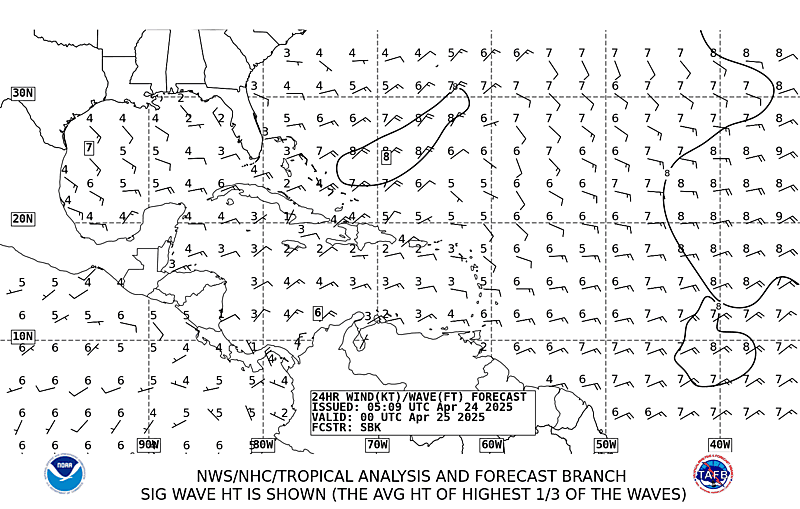
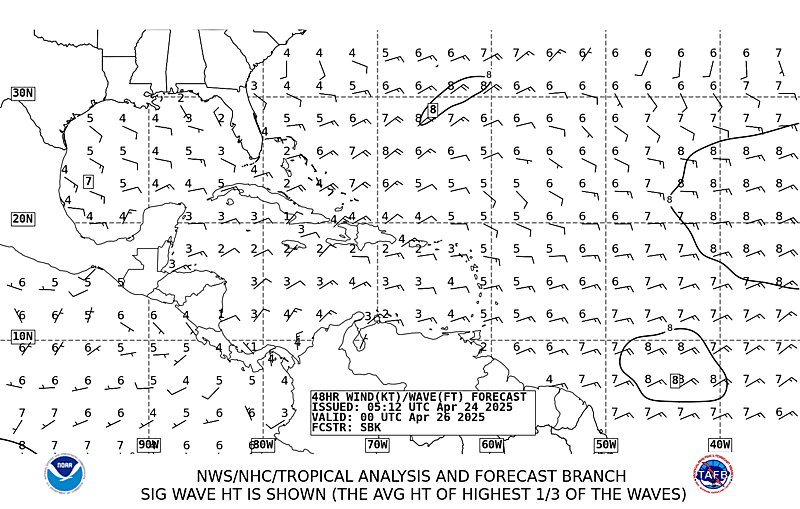
TAFB=Possible Tropical Cyclone within the next 24 hours:

Image

Image
0 likes   

User avatar
Nimbus
Category 5
Category 5
Posts: 5300
Joined: Mon Jul 19, 2004 10:54 am

Re: Invest 91L,East Atlantic-Discussions & Images

#159 Postby Nimbus » Mon Sep 10, 2007 5:44 am

Its fairly far south hard to tell how much influence the trough will have. There may be another ridge aiming this west again after the trough pulls it north a little. Even if it is not on a fish track after the first trough encounter at least the big islands may get a break.
0 likes   

User avatar
HURAKAN
Professional-Met
Professional-Met
Posts: 46086
Age: 38
Joined: Thu May 20, 2004 4:34 pm
Location: Key West, FL
Contact:

#160 Postby HURAKAN » Mon Sep 10, 2007 5:45 am

Makes since TC Formation could occurred within 48 hrs.

Image
0 likes   


Return to “2007”

Who is online

Users browsing this forum: No registered users and 4 guests