CAT 5 Hurricane Dean - Archived threads
Moderator: S2k Moderators

Re: Major Hurricane DEAN: 4 AM p317: Cat 5 landfall at 3:30, dis
Normandy wrote:Hockey007 wrote:To quote the 4am discussion
"GPS DROPSONDE IN THE
NORTHERN EYEWALL MEASURED A WIND SPEED OF 178 KT AVERAGED OVER THE
LOWEST 150 METERS OF THE SOUNDING."
Folks.....thats nearly 200 mph. WOW.
So... sustained 205mph winds, with gusts to what... 240? 250mph?
Can you imagine the sound of that?
0 likes
-
WeatherNLU

- Tropical Storm

- Posts: 218
- Joined: Fri Aug 29, 2003 12:50 pm
Re:
Normandy wrote:JESUS....im starting to thinking we were blessed with Katrina....Katrina is only a shadow of what a true beast could do.
Good lord.
Sorry, but I'll have to call you on this one. No one here was blessed, trust me. But I know what you are trying to say!
0 likes

-
Coredesat
I did recon maps, so no forecast. However:
----------------
Storm2K disclaimer: The following post is not an official forecast and should not be used as such. It is NOT endorsed by any professional institution or storm2k.org. For official information, please refer to the NHC and NWS products
CTCC disclaimer: These products are unofficial and are not certified by any Regional Specialized Meteorological Centre, Tropical Cyclone Warning Centre, or any official forecasting agency and may be subject to large errors. Refer to their products for official updates.
----------------
Intense Hurricane Dean (04L)
Tropical Cyclone Update - Atlantic
0900 UTC 21 August 2007
Satellite imagery and reconnaissance observations indicate that Hurricane Dean (04L) has made landfall near Chetumal, Mexico. The system underwent a sudden strengthening process just before landfall, and recon estimated pressures of 902-909 hPa and flight-level winds of 165 kt. The system looks impressive, with very deep convection surrounding a large eye. Outflow good in all quadrants, though a little ragged due to land interaction. Latest Dvorak T was T7.0/7.0 from SAB and TAFB, and CIMSS ADT is 7.1. Dean is the first Category 5 hurricane to make landfall in the Atlantic basin since Hurricane Andrew 15 years ago.
Estimated current position is 18.8°N 87.6°W, confidence good (GOES-East AVN/BD-IR). Maximum sustained winds (1-minute average) are estimated to be 145 knots (165 mph) gusting to 175 knots (200 mph). Estimated minimum pressure is 905 hPa. The system is moving to the west-northwest at 17 kt and weakening is expected due to land interaction. The system should emerge over the Bay of Campeche in the next 24 hours.
Next forecast at 1800 UTC August 21.
----------------
Storm2K disclaimer: The following post is not an official forecast and should not be used as such. It is NOT endorsed by any professional institution or storm2k.org. For official information, please refer to the NHC and NWS products
CTCC disclaimer: These products are unofficial and are not certified by any Regional Specialized Meteorological Centre, Tropical Cyclone Warning Centre, or any official forecasting agency and may be subject to large errors. Refer to their products for official updates.
----------------
Intense Hurricane Dean (04L)
Tropical Cyclone Update - Atlantic
0900 UTC 21 August 2007
Satellite imagery and reconnaissance observations indicate that Hurricane Dean (04L) has made landfall near Chetumal, Mexico. The system underwent a sudden strengthening process just before landfall, and recon estimated pressures of 902-909 hPa and flight-level winds of 165 kt. The system looks impressive, with very deep convection surrounding a large eye. Outflow good in all quadrants, though a little ragged due to land interaction. Latest Dvorak T was T7.0/7.0 from SAB and TAFB, and CIMSS ADT is 7.1. Dean is the first Category 5 hurricane to make landfall in the Atlantic basin since Hurricane Andrew 15 years ago.
Estimated current position is 18.8°N 87.6°W, confidence good (GOES-East AVN/BD-IR). Maximum sustained winds (1-minute average) are estimated to be 145 knots (165 mph) gusting to 175 knots (200 mph). Estimated minimum pressure is 905 hPa. The system is moving to the west-northwest at 17 kt and weakening is expected due to land interaction. The system should emerge over the Bay of Campeche in the next 24 hours.
Next forecast at 1800 UTC August 21.
0 likes


Re:
Normandy wrote:JESUS....im starting to thinking we were blessed with Katrina....Katrina is only a shadow of what a true beast could do.
Good lord.
Could you please calm down? Really, please. Your posts are starting to become more than a little... excessive, considering some of us have interests in the area that is being hit right now.
0 likes
-
Texashawk

- Category 2

- Posts: 579
- Joined: Tue Aug 14, 2007 1:50 am
- Location: Missouri City, TX (Houston)
Re:
Normandy wrote:JESUS....im starting to thinking we were blessed with Katrina....Katrina is only a shadow of what a true beast could do.
Good lord.
Hey Normandy... I live in Houston also... thank God he isn't coming this way...
0 likes
Re: Re:
gilbert88 wrote:Normandy wrote:JESUS....im starting to thinking we were blessed with Katrina....Katrina is only a shadow of what a true beast could do.
Good lord.
Could you please calm down? Really, please. Your posts are starting to become more than a little... excessive, considering some of us have interests in the area that is being hit right now.
Youre right, that statement was irresponsible. My apologies.
Its hard to stay calm however when such an awful event is occuring
0 likes

Re: Re:
gilbert88 wrote:Normandy wrote:JESUS....im starting to thinking we were blessed with Katrina....Katrina is only a shadow of what a true beast could do.
Good lord.
Could you please calm down? Really, please.
For what it's worth I agree with Normandy. I'm simply aghast as I sit here watching this thing. People are dying, homes are disintegrating, and unless that dropsonde was a dud, the winds are downright unspeakable. Good god. This changes everything.
0 likes
-
Chris_in_Tampa
- Category 5

- Posts: 5101
- Age: 42
- Joined: Thu Jun 21, 2007 11:06 pm
- Location: Tampa, Florida, USA
- Contact:
-
Texashawk
- Category 2
- Posts: 579
- Joined: Tue Aug 14, 2007 1:50 am
- Location: Missouri City, TX (Houston)
Re:
aerojad wrote:New Atlantic Basin Top 10 Intensity List:
1) Wilma - 2005 - 882mb
2) Gilbert - 1988 - 888mb
3) Labor Day - 1935 - 892mb
4) Rita - 2005 - 895mb
5) Allen - 1980 - 899mb
6) Katrina - 2005 - 902mb
7) Camille - 1969 - 905mb
7t) Mitch - 1998 - 905mb
9) Dean - 2007 - 906mb
10) Ivan - 2004 - 910mb
And 5 of them in the last 3 years.
0 likes
Re: Re:
Texashawk wrote:aerojad wrote:New Atlantic Basin Top 10 Intensity List:
1) Wilma - 2005 - 882mb
2) Gilbert - 1988 - 888mb
3) Labor Day - 1935 - 892mb
4) Rita - 2005 - 895mb
5) Allen - 1980 - 899mb
6) Katrina - 2005 - 902mb
7) Camille - 1969 - 905mb
7t) Mitch - 1998 - 905mb
9) Dean - 2007 - 906mb
10) Ivan - 2004 - 910mb
And 5 of them in the last 3 years.
that's quite frightening
0 likes
Re: Re:
Texashawk wrote:aerojad wrote:New Atlantic Basin Top 10 Intensity List:
1) Wilma - 2005 - 882mb
2) Gilbert - 1988 - 888mb
3) Labor Day - 1935 - 892mb
4) Rita - 2005 - 895mb
5) Allen - 1980 - 899mb
6) Katrina - 2005 - 902mb
7) Camille - 1969 - 905mb
7t) Mitch - 1998 - 905mb
9) Dean - 2007 - 906mb
10) Ivan - 2004 - 910mb
And 5 of them in the last 3 years.
That is something.
Despite how terrible this is....one thing to be thankful for.
Dean didn't hit 20 miles south....or Chetumal would have been facing one of the most severe northern eyewalls ever to strike land.
0 likes


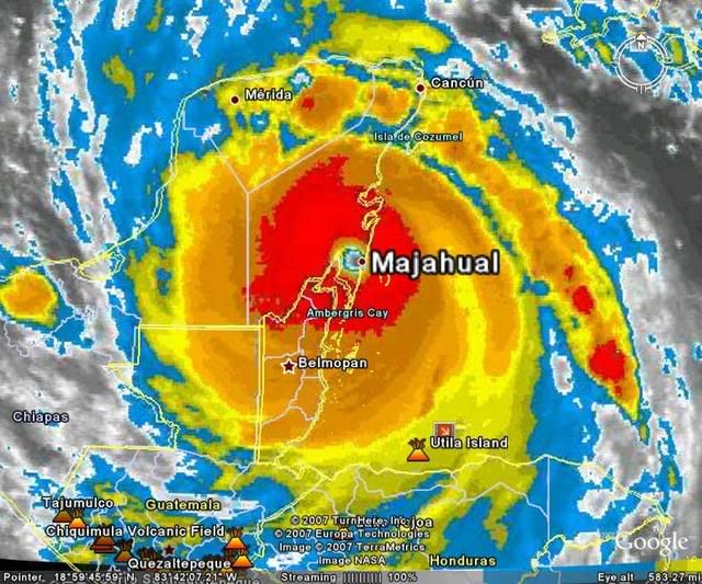
Re: Major Hurricane DEAN: 4 AM p317: Cat 5 landfall at 3:30, dis
Hmm, dead center on Majahual.
Must be wobbling because eyewall is VERY close now to Chetumal in that shot.
Must be wobbling because eyewall is VERY close now to Chetumal in that shot.
Last edited by Sanibel on Tue Aug 21, 2007 4:38 am, edited 1 time in total.
0 likes
-
Matt-hurricanewatcher
Re: Major Hurricane DEAN: 4 AM p317: Cat 5 landfall at 3:30, dis
Lets see how long it can keep that eye.
0 likes
-
Stratosphere747
- Category 5
- Posts: 3772
- Joined: Thu Sep 11, 2003 8:34 pm
- Location: Surfside Beach/Freeport Tx
- Contact:
Re: Major Hurricane DEAN: 4 AM p317: Cat 5 landfall at 3:30, dis
It's probably going to miss Chetumal by about 10/15 miles.

0 likes
Who is online
Users browsing this forum: No registered users and 62 guests