CAT 5 Hurricane Dean - Archived threads
Moderator: S2k Moderators
-
miamicanes177
- Category 5

- Posts: 1131
- Joined: Tue Aug 01, 2006 10:53 pm
Re: Major Hurricane DEAN: (8 AM page 279) Discussions, Analysis
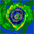
NHC confirms single eyewall and therefore the ewrc is now complete. This could join a very select group of Atlantic hurricanes to make landfall at category 5 intensity. My prediction is 904mb and 170mph.
0 likes

Re: Major Hurricane DEAN: (8 AM page 279) Discussions, Analysis
miamicanes177 wrote:NHC confirms single eyewall and therefore the ewrc is now complete. This could join a very select group of Atlantic hurricanes to make landfall at category 5 intensity. My prediction is 904mb and 170mph.
Put this post together with the one above it, and it made me cringe.
0 likes
Re: Major Hurricane DEAN: (8 AM page 279) Discussions, Analysis
Big red IR around core is all you need to know.
0 likes

Re: HURRICANE DEAN -Threat Area -Yucatan Peninsula
I am glad to hear they have been evacuating.
Stay safe!
Stay safe!
0 likes
-
wxmann_91

- Category 5
- Posts: 8007
- Age: 34
- Joined: Fri Jul 15, 2005 2:49 pm
- Location: Southern California
- Contact:
The sat presentation looks good. Once the eye clears out and the remnants of the inner eyewall are gone, we'll know that it's a Cat 5. Taking its sweet time though, and as long as it's moving as fast as it is, that's going to be a detriment. But unfortunately it could be a STRENGTHENING cat 5 at landfall which is something nowhere has seen, Andrew in 1992 (and then before that probably Labor Day 1935)? It's going to be unprecedented if it's a Cat 5 and strengthening, not to mention the storm surge due to the large size of this storm... this is going to be one bad tamale for someone.
0 likes
Re:
wxmann_91 wrote:The sat presentation looks good. Once the eye clears out and the remnants of the inner eyewall are gone, we'll know that it's a Cat 5. Taking its sweet time though, and as long as it's moving as fast as it is, that's going to be a detriment. But unfortunately it could be a STRENGTHENING cat 5 at landfall which is something nowhere has seen, Andrew in 1992 (and then before that probably Labor Day 1935)? It's going to be unprecedented if it's a Cat 5 and strengthening, not to mention the storm surge due to the large size of this storm... this is going to be one bad tamale for someone.
I do not think it's moving as fast as being noted by the NHC from 7:45-14:45 UTC as available by the floater Dean has moved 1.7* over that period;17X6miles=102miles/7hrs=14.6mph roughly.kevin
0 likes
Re: Major Hurricane DEAN: (8 AM page 279) Discussions, Analysis
My opinion is not endorsed by Storm2k:
The latest wobble WNW should clear Belize of the eye. Almost certain to miss to north of Belize now as Dean wobbles back into track. I expect Belize will get hurricane force return-side winds later in the am. The Cayes will get some surge driven from the inland side like Hurricane Keith. Mexico it is.
The latest wobble WNW should clear Belize of the eye. Almost certain to miss to north of Belize now as Dean wobbles back into track. I expect Belize will get hurricane force return-side winds later in the am. The Cayes will get some surge driven from the inland side like Hurricane Keith. Mexico it is.
0 likes

Re: Major Hurricane DEAN: (8 AM page 279) Discussions, Analysis
Any chance that Dean survives the crossing of Mexico and stays alive into the Pacific? Way too far out and a lot of people are in trouble until then, but the NHC forecast does have Dean as a TS at 72 hours pretty close to the coastline. Odds seem against it, but anything can happen with Cat 5 intensity to play with.....
0 likes
-
LAwxrgal

- S2K Supporter

- Posts: 1763
- Joined: Tue Jul 06, 2004 1:05 pm
- Location: Reserve, LA (30 mi west of NOLA)
Re: Major Hurricane DEAN: (8 AM page 279) Discussions, Analysis
Dean looks about as "good" as he ever has. Unfortunately, that means he's getting stronger. We are witnessing another historical-level hurricane and if he hits where he's going to hit at the intensity he's going to hit at, his name will almost certainly be retired.
0 likes
Re: HURRICANE DEAN -Threat Area -Yucatan Peninsula
If the eye maintains its large size, the south side of the eye wall may catch the city of Chetumal. However, if the storm deviates to a more due west track or comes in just a bit south of the forecasted landfall, Chetumal could receive a direct hit.
Chetumal is one of the larger cities, just north of the Mex/Belize border, and is the southern extent of the Maya Riveria. As of 2005, it had a population of around 137,000. The peninsula has several fishing villages on the immediate coastline that stretch north into the Maya Riveria that are popular tourists attractions. The old part of the city was destroyed in the 1950s by category five, Hurricane Janet. That part was rebuilt with concrete construction; however, the outskirts of the city have grown from the central core over the past 30 years and may lack the construction to withstand the winds that Dean may bring. If Dean makes a direct hit, the cay will help with the surge off the Caribbean, but there will still be surge off the shallow inlet of Chetumal Bay:
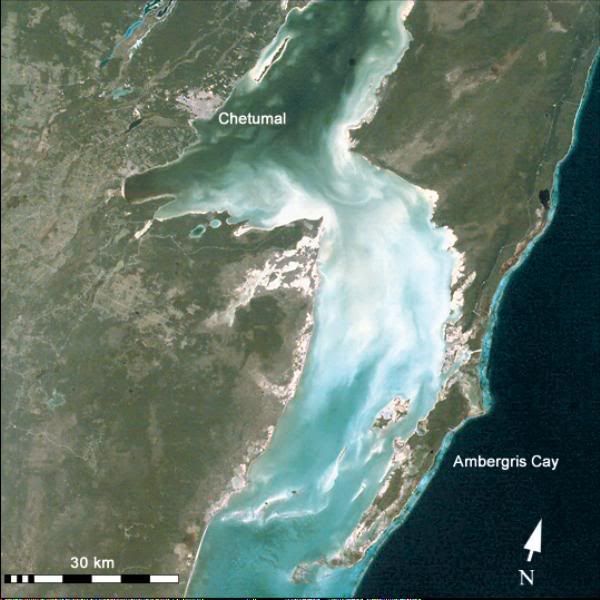
Chetumal is one of the larger cities, just north of the Mex/Belize border, and is the southern extent of the Maya Riveria. As of 2005, it had a population of around 137,000. The peninsula has several fishing villages on the immediate coastline that stretch north into the Maya Riveria that are popular tourists attractions. The old part of the city was destroyed in the 1950s by category five, Hurricane Janet. That part was rebuilt with concrete construction; however, the outskirts of the city have grown from the central core over the past 30 years and may lack the construction to withstand the winds that Dean may bring. If Dean makes a direct hit, the cay will help with the surge off the Caribbean, but there will still be surge off the shallow inlet of Chetumal Bay:
0 likes

Re:
Derek Ortt wrote:Tampico has more 300K, the Veracruz metro area has 800K
to be honest, I could not care less about tourism... I care about the number of people that this will actually impact and that number is going to be high. Also, read up on what Hurricane Diana in 1990 did to this area... at 85KT, it was far more deadly than Wilma and also destroyed 75K homes
Derek's point about the population is well taken. Veracruz (about 19.2) seems too far south
to take a big hit from Dean. Tuxpan and Tampico are another matter. Hopefully, by this time it will be Cat2 or less.
0 likes


Re: Major Hurricane DEAN: (8 AM page 279) Discussions, Analysis
LAwxrgal wrote:Dean looks about as "good" as he ever has. Unfortunately, that means he's getting stronger. We are witnessing another historical-level hurricane and if he hits where he's going to hit at the intensity he's going to hit at, his name will almost certainly be retired.
I agree -- Dean finally looks like how I would expect a Cat 4+ storm to look. There is a much better band of relatively cold cloud tops surrounding the eye. Granted, it's not perfect yet (the eye is cloudy, the coldest cloud tops could tighten up around the eye a little more, there still is a lacking of very cold cloud tops / tops colder than -80C, and so forth), but at least it looks more Cat 4 than before. So, given the trend, and the short-term track, Dean looks primed to strengthen into the first Cat 5 since 2005 (I think...).
0 likes

Re: HURRICANE DEAN -Threat Area -Yucatan Peninsula
Cozumel webcam http://www.cozumel-hotels.net/webcam/
0 likes

If you receive the BBC World Service:
Today at 1 p.m. Eastern, the BBC's World Have Your Say will attempt a link-up with a Jamaican radio station in the aftermath of Dean. If you don't receive the World Service, you can listen to the show online at the link above.
Today at 1 p.m. Eastern, the BBC's World Have Your Say will attempt a link-up with a Jamaican radio station in the aftermath of Dean. If you don't receive the World Service, you can listen to the show online at the link above.
0 likes

TCSCC ADVZY 065 DCC 08/20/07 CARIBBEAN HURRICANE TELCON_FYI
IMPACTED AREA: CUBA, JAMAICA, CAYMAN ISLANDS, MEXICO'S YUCATAN
PENINSULA
1. HURRICANE DEAN
PUBLIC ADVISORY - HURRICANE DEAN ADVISORY NUMBER 29A
LOCATION - 440 MILES/710 KM EAST OF BELIZE CITY
ARPT CLOSURES - REFER TO INTERNATIONAL NOTAMS FOR LATEST UPDATES
- HURRICANE WARNING: JAMAICA, CAYMAN ISLANDS, COAST
OF BELIZE AND THE EAST COAST OF THE YUCATAN PENINSULA
- HURRICANE WATCH: FROM NORTH OF CANCUN TO CIUDAD
DEL CARMEN ALONG THE NORTHERN AND WESTERN COASTS OF THE
YUCATAN PENINSULA OF MEXICO.
ROUTE CLOSURES - KINGSTON FIR CLOSED. REFER TO DCC ADVZY 015 FOR
AIRSPACE AVOIDANCE ROUTES.
DOMINICAN - SANTO DOMINGO (MDSD)NORMAL OPS, NO DAMAGE OR
REPUBLIC IMPACTS.
JAMAICA - KINGSTON CENTER CERTIFYING RADAR, COMMUNICATIONS
GOOD, STAFFING LIMITED, EXPECT TO BE ONLINE BY
1600Z.
- KINSTON AIRPORT (MKJP) CLOSED UNTIL FURTHER ADVISED TIME
DUE TO WIDESPREAD DAMAGE.
- MONTEGO BAY (MKJS)CLOSED EXCEPT TO EMERGENCY
RELIEF AIRCRAFT. EXPECTS TO BE OPERATIONAL 15Z
PENDING EQUIPMENT ASSESSMENT.
CAYMAN ISLANDS - ALL AIRPORTS CLOSED. DAMAGE ASSESMENT AND UPDATE
EXPECTED THIS MORNING.
MEXICO - 201900Z COZUMEL (MMCZ)EXPECTS TO CLOSE.
- 210400Z CANCUN (MMUN) EXPECTS TO CLOSE.
- MERIDA CENTER (ZMR)EXPECT IMPACT TO OVERFLIGHTS TOMORROW,
NORMAL OPS TODAY, WILL UPDATE 2200Z.
0 likes
-
cyberantonio
- Tropical Wave

- Posts: 5
- Joined: Thu Aug 16, 2007 5:48 pm
- Location: Tampico, Mexico
- Contact:
Re: Re:
.bigGbear wrote:Derek Ortt wrote:Tampico has more 300K, the Veracruz metro area has 800K
to be honest, I could not care less about tourism... I care about the number of people that this will actually impact and that number is going to be high. Also, read up on what Hurricane Diana in 1990 did to this area... at 85KT, it was far more deadly than Wilma and also destroyed 75K homes
Derek's point about the population is well taken. Veracruz (about 19.2) seems too far south
to take a big hit from Dean. Tuxpan and Tampico are another matter. Hopefully, by this time it will be Cat2 or less.
Just to update your information , Tampico has over 500K. We are following the track of Dean very closely at this time goverment has started meetings in order to prepare shelters. The area between Tampico - Tuxpan includes three important cities, the rest of it are rural areas.
0 likes
Re: GRACIAS!!! THANKS!!!!
hiflyer wrote:TCSCC ADVZY 065 DCC 08/20/07 CARIBBEAN HURRICANE TELCON_FYI
IMPACTED AREA: CUBA, JAMAICA, CAYMAN ISLANDS, MEXICO'S YUCATAN
PENINSULA
1. HURRICANE DEAN
PUBLIC ADVISORY - HURRICANE DEAN ADVISORY NUMBER 29A
LOCATION - 440 MILES/710 KM EAST OF BELIZE CITY
ARPT CLOSURES - REFER TO INTERNATIONAL NOTAMS FOR LATEST UPDATES
- HURRICANE WARNING: JAMAICA, CAYMAN ISLANDS, COAST
OF BELIZE AND THE EAST COAST OF THE YUCATAN PENINSULA
- HURRICANE WATCH: FROM NORTH OF CANCUN TO CIUDAD
DEL CARMEN ALONG THE NORTHERN AND WESTERN COASTS OF THE
YUCATAN PENINSULA OF MEXICO.
ROUTE CLOSURES - KINGSTON FIR CLOSED. REFER TO DCC ADVZY 015 FOR
AIRSPACE AVOIDANCE ROUTES.
DOMINICAN - SANTO DOMINGO (MDSD)NORMAL OPS, NO DAMAGE OR
REPUBLIC IMPACTS.
JAMAICA - KINGSTON CENTER CERTIFYING RADAR, COMMUNICATIONS
GOOD, STAFFING LIMITED, EXPECT TO BE ONLINE BY
1600Z.
- KINSTON AIRPORT (MKJP) CLOSED UNTIL FURTHER ADVISED TIME
DUE TO WIDESPREAD DAMAGE.
- MONTEGO BAY (MKJS)CLOSED EXCEPT TO EMERGENCY
RELIEF AIRCRAFT. EXPECTS TO BE OPERATIONAL 15Z
PENDING EQUIPMENT ASSESSMENT.
CAYMAN ISLANDS - ALL AIRPORTS CLOSED. DAMAGE ASSESMENT AND UPDATE
EXPECTED THIS MORNING.
MEXICO - 201900Z COZUMEL (MMCZ)EXPECTS TO CLOSE.
- 210400Z CANCUN (MMUN) EXPECTS TO CLOSE.
- MERIDA CENTER (ZMR)EXPECT IMPACT TO OVERFLIGHTS TOMORROW,
NORMAL OPS TODAY, WILL UPDATE 2200Z.
0 likes

A few more images from Jamaica and Dominican Republic (TWC/CNN): http://philadelphiaweather.blogspot.com ... ean-5.html
0 likes


Who is online
Users browsing this forum: No registered users and 11 guests