weatherguru18 wrote:sphelps8681 wrote:weatherguru18 wrote:A serious concern now guys...it appears the ULL has stalled. Why did the NHC push the cone south??
What will this mean for Texas?
Dean will be slingshoted toward Texas in my opinion.
Please, stop making statements without a shred of supporting evidence...you earlier stated in the thread that you wanted a hurricane to hit Texas. With that statement and your continuous claims of a Texas landfall when all of the pro-mets are suggesting otherwise really takes away any credibility and objectivity you have...no offense, but there are others in this thread who actually might take your posts seriously...which are mostly disinformation and overhyping.

Most of the pro-mets here seem to think that the ULL is not a concern and that Texas is in good shape...I really don't see the need to be this concerned this far out, seriously.
Here is what MWatkins had to say followed by Derek Ortt's thoughts:
Quick Sunday evening update...
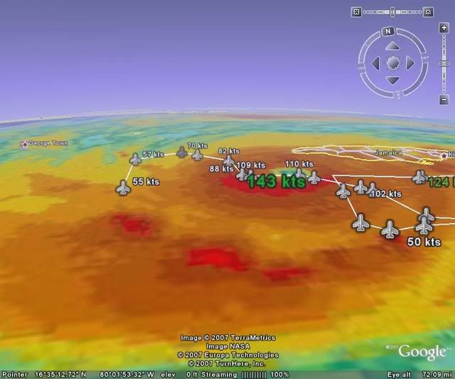
Dean is passing just south of Jamacia tonight, but they are on the strong side of the storm. So while they are fortunate that the eye is not passing directly over them, there will surely be reports of significant damage when Dean has cleared out tomorrow.
From there, as has been well documented by the NHC and others in this forum...the guidance has shifted significantly southward since Friday...and the upper low in the Gulf appears to be clearing the pattern quicky. There are now no models that take Dean into Texas...let alone the central Gulf as the GFDL was doing last week.
This should drive Dean into Mexico...where it may or may not emerge briefly in the Bay of Campechee before making a second Mexican landfall mid-week.
Although Texas is not "in the clear", it is hard to imagine Dean getting very far north in this steering environment. It is about as straight forward as a track forecast can be at this point.
Mexico Only: 95%
Mexico, US Landfall: 5%
MW
The eyewall scraped the south coast of Jamaica this afternoon as Dean moved to the WNW. 500mb winds and WV imagery show that the slightly north of due west track should continue for the next few days, taking Dean south of Cayman, into the Yucatan and into the Bay of Campeche. The upper low continues to retrograde to the west and should not impart an influence on the steering. This track is adjusted somewhat south of the previous and unfortunately brings the eye inland into the more populated parts of mainland Mexico.
Dean may have weakened slightly due to the interaction with Jamaica; however, conditions are very favorable for intensification into a category 5 hurricane when it moves into the open NW Caribbean and this forecast continues to indicate a landfalling category 5 hurricane on the Yucatan. Significant weakening will occur over the Yucatan; however, re-intensification is likely once back over the water. The landfall forecast is 100KT, but cannot be reflected in the table since landfall occurs between forecast points.