ATL: INVEST 93L - Discussion
Moderators: hurricanetrack, S2k Moderators

The posts in this forum are NOT official forecasts and should not be used as such. They are just the opinion of the poster and may or may not be backed by sound meteorological data. They are NOT endorsed by any professional institution or STORM2K. For official information, please refer to products from the National Hurricane Center and National Weather Service.

-
Kingarabian

- S2K Supporter

- Posts: 15979
- Joined: Sat Aug 08, 2009 3:06 am
- Location: Honolulu, Hawaii
Re: ATL: INVEST 93L - Discussion
Looks closer to the ICON vs other models. I think that's for sure. Question remains of how far sou5h it drops in the GOM. That will determine the land point and intensity.
7 likes
RIP Kobe Bryant
-
Sciencerocks
- Category 5

- Posts: 9152
- Age: 39
- Joined: Thu Jul 06, 2017 1:51 am

-
ScottNAtlanta

- Category 5
- Posts: 2366
- Joined: Sat May 25, 2013 3:11 pm
- Location: Atlanta, GA
Re: ATL: INVEST 93L - Discussion
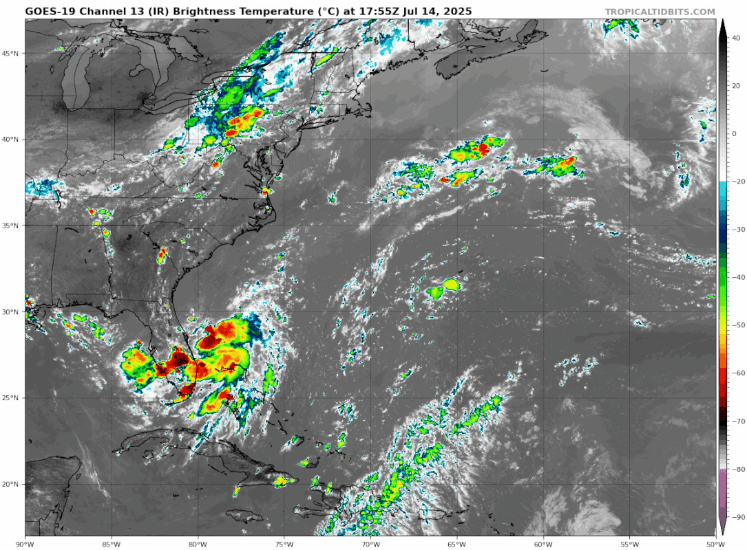
That sure looks like a vigorous LLC on the north side of the convection. It looks like a TD right now to me
2 likes
The posts in this forum are NOT official forecast and should not be used as such. They are just the opinion of the poster and may or may not be backed by sound meteorological data. They are NOT endorsed by any professional institution or storm2k.org. For official information, please refer to the NHC and NWS products.
-
Sciencerocks
- Category 5
- Posts: 9152
- Age: 39
- Joined: Thu Jul 06, 2017 1:51 am
Re: ATL: INVEST 93L - Discussion
ScottNAtlanta wrote:That sure looks like a vigorous LLC on the north side of the convection. It looks like a TD right now to me
100% agree. Likely closed and will probably become a PTD or PTS within the next 12 hours. I think the models bending this northward and keeping it over land is very unlikely. So it will probably restrengthen once it moves back into the gulf.
3 likes
-
ScottNAtlanta
- Category 5
- Posts: 2366
- Joined: Sat May 25, 2013 3:11 pm
- Location: Atlanta, GA
Re: ATL: INVEST 93L - Discussion
Sciencerocks wrote:ScottNAtlanta wrote:That sure looks like a vigorous LLC on the north side of the convection. It looks like a TD right now to me
100% agree. Likely closed and will probably become a PTD or PTS within the next 12 hours. I think the models bending this northward and keeping it over land is very unlikely. So it will probably restrengthen once it moves back into the gulf.
Most of them also seem to be initializing too far north as well
1 likes
The posts in this forum are NOT official forecast and should not be used as such. They are just the opinion of the poster and may or may not be backed by sound meteorological data. They are NOT endorsed by any professional institution or storm2k.org. For official information, please refer to the NHC and NWS products.

Re: ATL: INVEST 93L - Discussion
Sciencerocks wrote:ScottNAtlanta wrote:That sure looks like a vigorous LLC on the north side of the convection. It looks like a TD right now to me
100% agree. Likely closed and will probably become a PTD or PTS within the next 12 hours. I think the models bending this northward and keeping it over land is very unlikely. So it will probably restrengthen once it moves back into the gulf.
It's possible they're (or the ICON is) focusing on the wrong part of the energy. We'll see if we get any hints to shifts one way or the other in the 18z and 00z's.
0 likes

Re: ATL: INVEST 93L - Discussion
Still undergoing some northerly shear with the LLC on the far northern edge of convection. Drier air also on the west side. It is slowly wrapping up though. I guess no recon till tomorrow.
0 likes
-
Ian2401
- Category 1

- Posts: 307
- Joined: Thu Sep 14, 2017 5:55 pm
- Location: Tallahassee, Florida
- Contact:
Re: ATL: INVEST 93L - Discussion
GOES data is behind an hour and a half, but reflectivity returns seem to be diminishing somewhat in the far eastern parts of the storm. Hard to tell if this is actually happening without satellite data, but waning convection would line up with an approaching DMIN. I wouldn't be surprised to see convection hit a bit of a lull through this evening and tonight, with convection flaring back up late tonight / early tomorrow morning.
0 likes
B.S. Meteorology from Florida State '24 // Current M.S. Meteorology student at Florida State
Research Interests: Rapid Intensification, TC Climatology, TC Modeling
Consult the NHC for official information
Research Interests: Rapid Intensification, TC Climatology, TC Modeling
Consult the NHC for official information
-
wxman57

- Moderator-Pro Met

- Posts: 22973
- Age: 67
- Joined: Sat Jun 21, 2003 8:06 pm
- Location: Houston, TX (southwest)
Re: ATL: INVEST 93L - Discussion
cycloneye wrote:BobHarlem wrote:PTC or TD first? (or neither or jump to Dexter)
It depends on what recon finds in terms of organization and intensity.
I thought that recon was scheduled for tomorrow? It'll be over the Florida Peninsula tomorrow. Recon may have to wait until it moves over the NE Gulf on Wednesday morning.
I'm thinking 70% chance NHC will call it a depression by Wednesday afternoon and 80-90% by Thursday morning. Next shift at NHC will be bumping the numbers up considerably, considering how they handled Chantal and Barry.
3 likes
-
SouthFloridawx

- S2K Supporter
- Posts: 8346
- Age: 46
- Joined: Tue Jul 26, 2005 1:16 am
- Location: Sarasota, FL
- Contact:
Re: ATL: INVEST 93L - Discussion
Last edited by SouthFloridawx on Mon Jul 14, 2025 3:43 pm, edited 1 time in total.
0 likes
-
Tailgater33
- Tropical Depression

- Posts: 85
- Joined: Thu Jun 02, 2022 9:15 am
Re: ATL: INVEST 93L - Discussion
Watch the 5 day movie of 925 and 850mb vorticity on the CIMSS web page. Vorticity seems to be moving due south ATM.
0 likes
Re: ATL: INVEST 93L - Discussion
TampaWxLurker wrote:Interesting spot/direction for cyclogenesis and supposed eventual movement. Homegrown systems from stalled fronts that end up moving west usually seem to form more often in the eastern Gulf. Stuff like this forming just off the east coast of FL (in my somewhat hazy memory) seem to generally move north/northeast. Hopefully it doesn't get too much time to develop before moving over us.
Looking at the SST's, it's right over the Gulf stream, in water currently at ~29.5° C, warm but not super hot. JUST to the west of where it is though is a relatively cool area of SST's, offshore of Canaveral and the Treasure Coast. SST's in the 26-28° C range. Will have to see if the blob continues due south over the warmer gulf stream or tracks closer to those cooler waters near the coast.
Not sure what you are looking at, because the SST’s are in the 30-31 range as it gets closer to the Florida east coast. As it gets into the GOA, SST’s are 31+. Especially for an area along the north central gulf coast. Plenty of fuel.
1 likes
-
jaguars_22
- Category 2

- Posts: 586
- Joined: Tue Jun 20, 2017 2:26 pm
- Location: Victoria TX
Re: ATL: INVEST 93L - Discussion
looking at the NAM it seems to think the system will split sending the lower pressures inland and sending a separate system into the gulf. Maybe the latest euro isn't out to lunch... 
0 likes
-
jaguars_22
- Category 2
- Posts: 586
- Joined: Tue Jun 20, 2017 2:26 pm
- Location: Victoria TX
Re: ATL: INVEST 93L - Discussion
I believe the latest icon is initializing the location much better this run!
0 likes
-
TomballEd
- Category 2
- Posts: 682
- Age: 61
- Joined: Wed Aug 16, 2023 4:52 pm
- Location: Spring/Klein area, not Tomball
Re: ATL: INVEST 93L - Discussion
The thunderstorms forming over land where the ECSB and WCSB are meeting may collapse as the sun starts setting, cold outflow from collapsing storms may not help 93L.
0 likes
-
Hypercane_Kyle

- Category 5
- Posts: 3350
- Joined: Sat Mar 07, 2015 7:58 pm
- Location: Cape Canaveral, FL
Re: ATL: INVEST 93L - Discussion
Looks like a developing TD to me... models might be absolutely clueless for this one.
1 likes
My posts are my own personal opinion, defer to the National Hurricane Center (NHC) and other NOAA products for decision making during hurricane season.
Re: ATL: INVEST 93L - Discussion
The "Shrimp" look is something I've seen in strengthening tropical systems before, but not sure how much of it is legit or just part of the nighttime storm cycle. If it's legit, may as well make the 8pm TWO 80-90%.
3 likes


Re: ATL: INVEST 93L - Discussion
We've had severe thunderstorms here over the peninsula on the west coast near Tampa this afternoon with daytime heating. Storms were heading from north to south as they appear to be steered by counterclockwise flow from the low pressure to the east. This low pressure is definitely packing a punch.
0 likes
-
MississippiWx

- S2K Supporter
- Posts: 1697
- Joined: Sat Aug 14, 2010 1:44 pm
- Location: Hattiesburg, Mississippi
Re: ATL: INVEST 93L - Discussion
BobHarlem wrote:The "Shrimp" look is something I've seen in strengthening tropical systems before, but not sure how much of it is legit or just part of the nighttime storm cycle. If it's legit, may as well make the 8pm TWO 80-90%.
https://i.postimg.cc/nrPrY4bY/goes19-ir-nwatl.gif
I’m not sure it’s really a shrimp look. I think a convergence zone setup inland between the sea breeze from the west and the flow around 93L from the east. This area will likely die out once the sun goes down. In fact, the majority of the convection over water is weakening as we hit diurnal minimum over water.
Hard to say what is going on underneath the hood without ASCAT/recon. Just from visible, it appears the surface low/vort is moving off the west and the mid level area is dropping southwest a bit. If this continues, the globals will be correct. Long way to go for this to be a TC…in my opinion.
2 likes
This post is not an official forecast and should not be used as such. It is just the opinion of MississippiWx and may or may not be backed by sound meteorological data. It is not endorsed by any professional institution including storm2k.org. For Official Information please refer to the NHC and NWS products.
Return to “Active Storms/Invests - Atlantic/EastPAC/CentralPAC/MED”
Who is online
Users browsing this forum: No registered users and 8 guests