Dianmu Advisories
Moderator: S2k Moderators
-
SupertyphoonTip

- Tropical Depression

- Posts: 77
- Joined: Sat May 29, 2004 12:50 am
- Location: Cape Cod, Massachusetts
It isn't historic, but it is unusual. Going back to 1974 (30 years), out of 491 typhoons, 21 were 150 knots or higher at maximum wind speed, the last one being Maemi last year. However, since 1974, only 2 150-knot supertyphoons have developed before July. These were in 1986 and 2000. Now, Supertyphoon Dianmu is added to that list.
0 likes


-
HURAKAN

- Professional-Met

- Posts: 46086
- Age: 37
- Joined: Thu May 20, 2004 4:34 pm
- Location: Key West, FL
- Contact:
The link below is an amazing loop of ST Dianmu:
http://www.goes.noaa.gov/guam/guamloops ... color.html
http://www.goes.noaa.gov/guam/guamloops ... color.html
0 likes


-
Hurricanehink

- S2K Supporter

- Posts: 2023
- Joined: Sun Nov 16, 2003 2:05 pm
- Location: New Jersey
Re: Unbeliveable
bevgo wrote:AllI can say is WOW! I am sure glad these storms don't develop in this area.
Ditto that. Though it would be cool, I would never want a storm like that bearing down on me!
0 likes
-
SupertyphoonTip
- Tropical Depression
- Posts: 77
- Joined: Sat May 29, 2004 12:50 am
- Location: Cape Cod, Massachusetts

Unfortunately...
These storms can and will develop in the Atlantic basin from time to time--usually in the Western Caribbean or the gulf of Mexico if the conditions are just right. Hurricane Gilbert and Mitch being good examples of storms every bit as large and powerful as Western Pacific Super Typhoons. And, of course, Camille and the Labor Day 1935 Hurricane, though more compact, were also just as intense. Considering pressure differences between the Atlantic and the Pacific, when Atlantic basin hurricanes maintain pressures below 915 mb for a day or more, their wind speeds will be right up there with the strongest the Western Pacific has to offer. It is astonishing to think that Gilbert's wind speeds may have not even had enough time to top out prior to landfall over the Yucatan because typically an Atlantic storm with sub 900 mb readings, given enough time for the centripetal wind forces to catch up, should be over 200 miles per hour sustained. What ifs being considered, imagine if Gilbert had taken on a more NW component and moved through the strait into the central Gulf of Mexico. In avoiding the Yucatan landmass, Gilbert would have had a frightening chance to maintain a pressure around 900 mb until a coastal landfall in the States. There will be a monster hurricane in the Gulf again some day, it is only a matter of atmospheric conditions and timing.
0 likes
-
HURAKAN
- Professional-Met
- Posts: 46086
- Age: 37
- Joined: Thu May 20, 2004 4:34 pm
- Location: Key West, FL
- Contact:
Is beautiful to see these monsters pop up from time to time, or from year to year, but is always wonderful to see them stay away as far as possible from any landmass. One of these monsters can make a weak country economy go really downhill, and the deaths are counted always by the thousands.
0 likes
-
Opal storm
-
cycloneye

- Admin

- Posts: 139173
- Age: 67
- Joined: Thu Oct 10, 2002 10:54 am
- Location: San Juan, Puerto Rico
Opal storm wrote:Over there they get all the good stuffLooks like there could be gusts to 190mph.
That is nothing to laugh about when that kind of monster with winds above 180 mph goes to any place in the world.
0 likes
Visit the Caribbean-Central America Weather Thread where you can find at first post web cams,radars
and observations from Caribbean basin members Click Here
and observations from Caribbean basin members Click Here
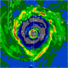
Supertyphoon Dianmu most likely peaking at 155 knots
Updating the tropics today shows several things going on. The lead story is supertyphoon Dianmu, which has most likely peaked in intensity at this particular hour after a period of very rapid deepening. Meanwhile the Gulf Of Mexico is quiet, however tropical moisture continues to advect north from the Gulf ahead of an upper level disturbance centered over the eastern art of Texas. The biggest threat with this upper low is heavy rain. However there was a tornado warning issued around 7 AM CDT for the Galveston County area including League City, TX. This was most likely a rain wrapped tornado and was doppler radar indicated. As a result, any storms could produce an isolated tornado spinup from eastern Texas and Louisiana northward through Arkansas, western Tennessee, and western Kentucky as well. However with respect to tropical development, nothing is expected in the Gulf Of Mexico over the next few days.
Elsewhere in the Atlantic, a tropical wave continues to head towards the Leeward and Windward Islands this afternoon. To the west of this Tropical Wave, winds are from the northeast. To the east of this wave, winds are from the southeast. With the wave axis or wind shift line is where the showers and storms are located. Heavy rain squalls are the primary threats for the Leewards and Windward Islands over the next day or so. No tropical development is expected as strong southwesterly winds aloft will preclude such occurrance.
The biggest story in the tropics today is out in the western Pacific where a super typhoon continues to make headlines. Maximum sustained winds are near 155 knots with gusts to 190 knots. Super typhoon Dianmu has a minimum central pressure of an estimated 879 millibars. Dianmu is centered near latitude 15.7 north, longitude 135.6 east. Movement continues towards the northwest at near 8 mph. This super typhoon has most likely peaked in intensity. As it interacts with an approaching upper trough, expect some weakening over the next several days. However landfall is still a possibility over central Japan as a strong category 1 or category 2 typhoon. That can still cause damage. This system will continued to be monitored.
Jim
0 likes
-
Rainband
-
Opal storm
Who is online
Users browsing this forum: No registered users and 44 guests