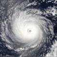
Eye filling in does NOT mean:
- The Hurricane Is Dipping South
- The Hurricane Will Be A Tropical Storm Tomorrow
- There is Rapid Decay
Eye filling in DOES mean:
- The Hurricane Could Be Going Through an ERC
- The Hurricane Should Weaken Somewhat Tomorrow
REMEMBER:
- The NE Tip of Yucatan is VERY flat
- The Hurricane Will Be Over a Small Part of It
- The Hurricane May Be over the GOM in 24 Hours
Hurricane Wilma - Cat. 5
Moderator: S2k Moderators
-
calculatedrisk
- Tropical Depression

- Posts: 76
- Joined: Fri Jul 15, 2005 3:39 pm
NCEP COUPLED GFDL HURRICANE MODEL FORECAST MADE FOR
HURRICANE WILMA 24L
INITIAL TIME 0Z OCT 22
DISCLAIMER ... THIS INFORMATION IS PROVIDED AS GUIDANCE. IT
REQUIRES INTERPRETATION BY HURRICANE SPECIALISTS AND SHOULD
NOT BE CONSIDERED AS A FINAL PRODUCT. PLEASE SEE THE TPC/NHC
OFFICIAL FORECAST.
FORECAST STORM POSITION
HOUR LATITUDE LONGITUDE HEADING/SPEED(KT)
0 20.7 86.8 330./ 4.1
6 20.8 87.1 293./ 2.5
12 21.0 87.1 351./ 2.4
18 21.4 87.0 10./ 4.0
24 21.8 86.9 20./ 4.1
30 22.2 86.7 30./ 4.3
36 23.0 86.3 25./ 8.7
42 23.7 85.7 41./ 8.9
48 24.7 84.6 47./14.1
54 25.7 83.0 58./17.4
60 27.1 81.0 54./22.9
66 28.9 78.4 57./28.7
72 31.5 75.1 52./38.7
78 35.0 71.6 45./45.7
84 39.2 68.1 40./50.6
90 42.6 66.1 31./37.2
96 44.7 65.8 8./20.9
102 45.8 66.4 330./11.7
108 46.2 65.6 63./ 7.3
114 46.5 64.2 79./ 9.6
120 46.3 63.5 104./ 5.0
126 45.8 62.9 124./ 6.3
0 likes
DoctorHurricane2003 wrote:Eye filling in does NOT mean:
- The Hurricane Is Dipping South
- The Hurricane Will Be A Tropical Storm Tomorrow
- There is Rapid Decay
Eye filling in DOES mean:
- The Hurricane Could Be Going Through an ERC
- The Hurricane Should Weaken Somewhat Tomorrow
REMEMBER:
- The NE Tip of Yucatan is VERY flat
- The Hurricane Will Be Over a Small Part of It
- The Hurricane May Be over the GOM in 24 Hours
Dont forget it is also rather swampy as well
Shawn
0 likes

Thoughts on Wilma:
Wilma is a bit inland over Mexico, so it will start weakening overnight. Biggest question is when the eye moves over water, since Wilma has shown that it is capable of maintaining strength as long as the eye is over water (it was Cat 4 by recon all day).
Eye seems to have collapsed a bit, so if Wilma spends too much more time over the YP, it'll emerge much weakened. On the other hand, it seems to be "shrinking" unlike many storms which "grow" and lose their inner core when they hit land. So, in this case, if it keeps the core and low pressure, it'll likely spin right back up over water. Tonight is critical.
0 likes
-
calculatedrisk
- Tropical Depression
- Posts: 76
- Joined: Fri Jul 15, 2005 3:39 pm
-
Aquawind

- Category 5

- Posts: 6714
- Age: 62
- Joined: Mon Jun 16, 2003 10:41 pm
- Location: Salisbury, NC
- Contact:
Looks Faster..
http://moe.met.fsu.edu/cgi-bin/gfdltc2. ... =Animation
quote="calculatedrisk"]NCEP COUPLED GFDL HURRICANE MODEL FORECAST MADE FOR
HURRICANE WILMA 24L
INITIAL TIME 0Z OCT 22
DISCLAIMER ... THIS INFORMATION IS PROVIDED AS GUIDANCE. IT
REQUIRES INTERPRETATION BY HURRICANE SPECIALISTS AND SHOULD
NOT BE CONSIDERED AS A FINAL PRODUCT. PLEASE SEE THE TPC/NHC
OFFICIAL FORECAST.
FORECAST STORM POSITION
HOUR LATITUDE LONGITUDE HEADING/SPEED(KT)
0 20.7 86.8 330./ 4.1
6 20.8 87.1 293./ 2.5
12 21.0 87.1 351./ 2.4
18 21.4 87.0 10./ 4.0
24 21.8 86.9 20./ 4.1
30 22.2 86.7 30./ 4.3
36 23.0 86.3 25./ 8.7
42 23.7 85.7 41./ 8.9
48 24.7 84.6 47./14.1
54 25.7 83.0 58./17.4
60 27.1 81.0 54./22.9
66 28.9 78.4 57./28.7
72 31.5 75.1 52./38.7
78 35.0 71.6 45./45.7
84 39.2 68.1 40./50.6
90 42.6 66.1 31./37.2
96 44.7 65.8 8./20.9
102 45.8 66.4 330./11.7
108 46.2 65.6 63./ 7.3
114 46.5 64.2 79./ 9.6
120 46.3 63.5 104./ 5.0
126 45.8 62.9 124./ 6.3[/quote]
0 likes
-
markymark8
- Tropical Storm

- Posts: 111
- Joined: Sat Oct 08, 2005 11:57 am
- Location: North Carolina
Anybody with good sight can see she is moving more to the west to northwest. If she does not start moving NNW like earlier tonight she will go the long way around like the NHC path in the 5 pm advisory and be a cat 1 hitting Florida. She was on that more northerly course earlier but not now. http://www.ssd.noaa.gov/PS/TROP/DATA/RT ... -loop.html
0 likes
-
Matt-hurricanewatcher
-
gunner1551
- Tropical Storm
- Posts: 143
- Joined: Thu Sep 16, 2004 12:08 pm
I still cant believe all the comments about this just goin away!! Remember Stan had by my guess at the very least 5 times longer of a trip across Mexico and he was darn close to makin it!! In addition Wilma's trip will be very flat when compared to Stans mountain filled journey. It will dissapate some what but not to the degree that some on here and wishing or forcasting it will.
0 likes
-
markymark8
- Tropical Storm
- Posts: 111
- Joined: Sat Oct 08, 2005 11:57 am
- Location: North Carolina
That looks like a strong Cat 2 to me. she is going down fast and alot of people were commentimg on how the flat landmass wouldnt do to much to her. Her eye is almost GONE not to mention she is almost stationary. Please!!!  http://www.ssd.noaa.gov/PS/TROP/DATA/RT ... IR4/20.jpg
0 likes

I don understand how people find this a GOOD thing that she is stalling over the Yucatan? You want to know how long the NE and N eyewall (recorded strongest part of Wilma) has been slamming Cancun? 4 hours and counting? And you know what? It is STILL slamming them. That is 4+ hours of 135+ mph winds, the structural damage their is going to be unreal. The guy posting on stormcarib is already reporting this:
"Several hotels have been reported to be severally damaged, and the Lagoon is now meeting the ocean in various parts of the hotel zone."
Id rather it just get out of there, they have had enough.
"Several hotels have been reported to be severally damaged, and the Lagoon is now meeting the ocean in various parts of the hotel zone."
Id rather it just get out of there, they have had enough.
0 likes
-
jlauderdal
- S2K Supporter

- Posts: 7240
- Joined: Wed May 19, 2004 5:46 am
- Location: NE Fort Lauderdale
- Contact:
Normandy wrote:I don understand how people find this a GOOD thing that she is stalling over the Yucatan? You want to know how long the NE and N eyewall (recorded strongest part of Wilma) has been slamming Cancun? 4 hours and counting? And you know what? It is STILL slamming them. That is 4+ hours of 135+ mph winds, the structural damage their is going to be unreal. The guy posting on stormcarib is already reporting this:
"Several hotels have been reported to be severally damaged, and the Lagoon is now meeting the ocean in various parts of the hotel zone."
Id rather it just get out of there, they have had enough.
its for selfish reasons. the longer it is there hopefully the weaker it is when it gets to florida. we have had enough to. its as easy as that.
0 likes
-
bigmoney755
161mph winds in cancun. "Winds currently in Cancun are at 260 kph and Wilma continues to move at 7 kph."
shown near the bottom of page.
http://help.stormcarib.com/read.php?5,2223
shown near the bottom of page.
http://help.stormcarib.com/read.php?5,2223
Last edited by bigmoney755 on Sat Oct 22, 2005 2:03 am, edited 1 time in total.
0 likes


jlauderdal wrote:Normandy wrote:I don understand how people find this a GOOD thing that she is stalling over the Yucatan? You want to know how long the NE and N eyewall (recorded strongest part of Wilma) has been slamming Cancun? 4 hours and counting? And you know what? It is STILL slamming them. That is 4+ hours of 135+ mph winds, the structural damage their is going to be unreal. The guy posting on stormcarib is already reporting this:
"Several hotels have been reported to be severally damaged, and the Lagoon is now meeting the ocean in various parts of the hotel zone."
Id rather it just get out of there, they have had enough.
its for selfish reasons. the longer it is there hopefully the weaker it is when it gets to florida. we have had enough to. its as easy as that.
Florida can handle a hurricane a lot better than one of the poorest countries on earth.
Last edited by JTD on Sat Oct 22, 2005 2:04 am, edited 1 time in total.
0 likes
jlauderdal wrote:Normandy wrote:I don understand how people find this a GOOD thing that she is stalling over the Yucatan? You want to know how long the NE and N eyewall (recorded strongest part of Wilma) has been slamming Cancun? 4 hours and counting? And you know what? It is STILL slamming them. That is 4+ hours of 135+ mph winds, the structural damage their is going to be unreal. The guy posting on stormcarib is already reporting this:
"Several hotels have been reported to be severally damaged, and the Lagoon is now meeting the ocean in various parts of the hotel zone."
Id rather it just get out of there, they have had enough.
its for selfish reasons. the longer it is there hopefully the weaker it is when it gets to florida. we have had enough to. its as easy as that.
You all would recieve a marginal 3 at best, and Florida's building codes are definitely strong enough to survive that (especially a FAST moving cat 3). id rather it move out and quickly rake across Florida because it wont do nearly the damage it will do to cancun if it sits over it for another day or so (minus coastal areas of florida which would be devastated).
0 likes

-
DoctorHurricane2003
-
Matt-hurricanewatcher
DoctorHurricane2003 wrote:Yep I would much rather it hit the US than somewhere where 3000 people will die
humans are humans no matter where they live. Remember, that could have been you in Mexico
I agree...Also They are saying that it suppose to stay this way for the next 20 years. Just think if next year makes this year seem like 2004. I can see why so many ships got sunk with gold in the 12th to 15th centrys...I Also heard about them trying to build on the Gulf coast around 14th centry. I believe this was Florida they tryed this in. They got hit with hurricane after hurricane. In finally they just gave up.
I think periods like this are normal...In believe we got at least 10 more years. Just like those people we are going to have everything on the coast destroyed. If in fact this is going to last another 20 years.
I believe very strongly that we are in trouble.
0 likes
Who is online
Users browsing this forum: No registered users and 20 guests