Hurricane Wilma - Cat. 5
Moderator: S2k Moderators
-
Matt-hurricanewatcher

THead wrote:Think you could say it officially made landfall on the mainland YP judging by the 3:15 frame? Looks like the center of the eye is now on the mainland coast.

I concur... just N of Playa del Carmen
Last edited by gotoman38 on Fri Oct 21, 2005 11:05 pm, edited 1 time in total.
0 likes
-
Stratosphere747
- Category 5

- Posts: 3772
- Joined: Thu Sep 11, 2003 8:34 pm
- Location: Surfside Beach/Freeport Tx
- Contact:
wxmann_91 wrote:gotoman38 wrote:And the hotel zone... sitting on a barrier island.... I would expect part to be completely washed through?
Photos in another thread show that. Thankfully, though, waters around Cancun are fairly deep, still, a 10-15 ft surge is quite possible.
The problem is the constant winds.
I think some people are forgetting that this event for Cozumel and Cancun started around 8pm Thursday, yet here we are late in the evening on Friday.
Scott
0 likes
-
superfly


superfly wrote:Cozumel in the SE eyewall now. Cancun is in between the inner and outer eyewalls, should be in the NE inner eyewall soon depending on speed of storm.
Are you sure of this?
Can Cun is on the NE tip of the peninsula and extends S about 10 miles.... it looks to me that they are taking the brunt of the outer eyewall. They are about an hour's drive N from Playa del Carmen which is directly W of San Miguel de Cozumel... on the center west of the island.
0 likes
-
Windtalker1

- S2K Supporter

- Posts: 523
- Age: 37
- Joined: Sun Jul 31, 2005 11:00 am
- Location: Mesa, Arizona
 [/url]
wxmann_91 wrote:gotoman38 wrote:And the hotel zone... sitting on a barrier island.... I would expect part to be completely washed through?
Photos in another thread show that. Thankfully, though, waters around Cancun are fairly deep, still, a 10-15 ft surge is quite possible, and a barrier island could indeed be washed through.
Try http://stormcarib.com/reports/2005/mexico.shtml that is the site under the heading photos from cancun
0 likes

-
wxmann_91

- Category 5
- Posts: 8007
- Age: 34
- Joined: Fri Jul 15, 2005 2:49 pm
- Location: Southern California
- Contact:
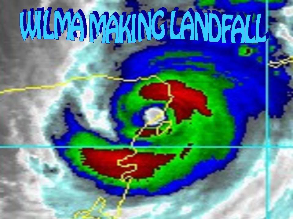
Radar image shows two things:
a) Wilma is going to make landfall within the next hour, but sats can be deceiving, it has not made landfall yet.
b) The outer eyewall is merging with the inner eyewall and the moat is filling. Cancun is in the outer eyewall, and as the moat fills, the point becomes trivial.

(To see full-sized version: http://img486.imageshack.us/my.php?image=cancunradar524xu.jpg)
a) Wilma is going to make landfall within the next hour, but sats can be deceiving, it has not made landfall yet.
b) The outer eyewall is merging with the inner eyewall and the moat is filling. Cancun is in the outer eyewall, and as the moat fills, the point becomes trivial.
(To see full-sized version: http://img486.imageshack.us/my.php?image=cancunradar524xu.jpg)
0 likes

Good forecasting? From 5PM Discussion
INITIAL 21/2100Z 20.6N 86.9W 120 KT
12HR VT 22/0600Z 20.9N 87.3W 100 KT...INLAND
24HR VT 22/1800Z 21.2N 87.5W 80 KT...INLAND
36HR VT 23/0600Z 21.8N 87.4W 80 KT
From 11 PM Discussion
INITIAL 22/0300Z 20.8N 86.9W 120 KT
12HR VT 22/1200Z 21.2N 87.1W 100 KT...INLAND
24HR VT 23/0000Z 21.7N 87.2W 90 KT...OVER WATER
36HR VT 23/1200Z 22.3N 86.9W 95 KT
The 5PM looks to be wrong in that it wont make it to 87.5 west. But will Wilma even make it to 87.2 West? Maybe. But they already backed off on numbers just from this afternoon. I'm not blaming the NHC they need more $, more data and more people.
0 likes


-
Brent
- S2K Supporter
- Posts: 38734
- Age: 37
- Joined: Sun May 16, 2004 10:30 pm
- Location: Tulsa Oklahoma
- Contact:
CronkPSU wrote:can't tell where that is...is that still around ft meyers?
Close... I have stared at it far too long trying to figure it out.
Last edited by Brent on Fri Oct 21, 2005 11:36 pm, edited 1 time in total.
0 likes
#neversummer
-
tampastorm
- Category 1

- Posts: 434
- Joined: Thu Aug 12, 2004 9:22 pm
- Location: TAMPA
Who is online
Users browsing this forum: No registered users and 31 guests