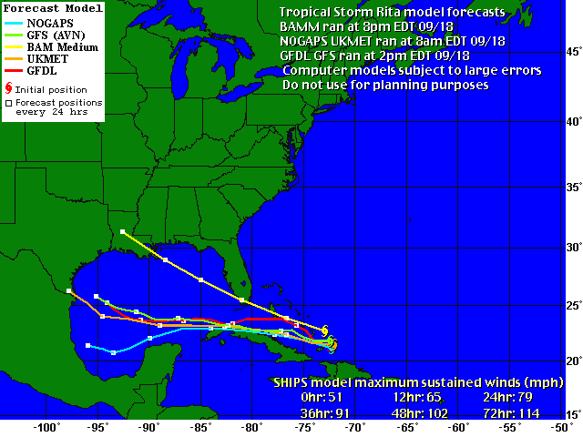
Hurricane Rita - Cat. 5

Moderator: S2k Moderators

Message
Author
User avatar
LAwxrgal
S2K Supporter
S2K Supporter
Posts: 1763
Joined: Tue Jul 06, 2004 1:05 pm
Location: Reserve, LA (30 mi west of NOLA)

#161 Postby LAwxrgal » Sun Sep 18, 2005 7:18 pm

Brent wrote::eek:

Miami and New Orleans... ugh.

Good thing BAMM is not a good tropical model.


Exactly. If this were to pan out Rita would finish what Katrina started...the complete destruction of SE-LA. Puts the eye right over my house...
Last edited by LAwxrgal on Sun Sep 18, 2005 7:20 pm, edited 1 time in total.
0 likes   
Andrew 92/Isidore & Lili 02/Bill 03/Katrina & Rita 05/Gustav & Ike 08/Isaac 12 (flooded my house)/Harvey 17/Barry 19/Cristobal 20/Claudette 21/Ida 21 (In the Eye)/Francine 24
Wake me up when November ends

dwg71
Category 5
Category 5
Posts: 2349
Joined: Wed Jun 08, 2005 4:34 pm

#162 Postby dwg71 » Sun Sep 18, 2005 7:18 pm

Image

Not much consensous.....
0 likes   

User avatar
cajungal
Category 5
Category 5
Posts: 2330
Age: 49
Joined: Sun Mar 14, 2004 9:34 pm
Location: Schriever, Louisiana (60 miles southwest of New Orleans)

#163 Postby cajungal » Sun Sep 18, 2005 7:19 pm

Good thing because we sure don't need it. My brother just left to go to Houston today. Possibly relocated there for 3 months because he works at the Court of Appeals in New Orleans. And it got some flood damage. So, I hope it does not go Houston either. Lots of evacuees in Houston, too. Crash into Mexico, Rita, I know you are thirsty for a good margarita.
0 likes   

User avatar
gatorcane
S2K Supporter
S2K Supporter
Posts: 23691
Age: 47
Joined: Sun Mar 13, 2005 3:54 pm
Location: Boca Raton, FL

#164 Postby gatorcane » Sun Sep 18, 2005 7:20 pm

yes but notice that the BAMM has initialized the center farther north which in my opinion is correct. The UKMET and GFDL initialize farther south. Where the final center winds up is key to this track...we'll know more by 11pm :eek:
Last edited by gatorcane on Sun Sep 18, 2005 7:21 pm, edited 1 time in total.
0 likes   

User avatar
Ivanhater
Storm2k Moderator
Storm2k Moderator
Posts: 11160
Age: 38
Joined: Fri Jul 01, 2005 8:25 am
Location: Pensacola

#165 Postby Ivanhater » Sun Sep 18, 2005 7:20 pm

dwg71 wrote:Image

Not much consensous.....


good God, haaaaa throw a dart
0 likes   

User avatar
HurricaneGirl
Category 5
Category 5
Posts: 5839
Age: 60
Joined: Thu Feb 06, 2003 9:45 am
Location: Clare, Michigan
Contact:

#166 Postby HurricaneGirl » Sun Sep 18, 2005 7:20 pm

:eek: Holy Crap! :eek:
0 likes   

User avatar
jasons2k
Storm2k Executive
Storm2k Executive
Posts: 8245
Age: 51
Joined: Wed Jul 06, 2005 12:32 pm
Location: The Woodlands, TX

#167 Postby jasons2k » Sun Sep 18, 2005 7:20 pm

BAMM may not be good to use, however, I do look for others to trend more northward. Doubt LA has anything to worry about, but very worried here in SE TX.
0 likes   

User avatar
hicksta
Category 5
Category 5
Posts: 1108
Age: 35
Joined: Thu Jul 14, 2005 12:16 am
Location: Kemah Texas/ Baton Rogue LA

#168 Postby hicksta » Sun Sep 18, 2005 7:21 pm

Yall, the BAMMS are horrible at tropics. Dont look at those. GFDL GFS CMC UKMET GFDI and those are the ones to watch.
0 likes   

User avatar
gatorcane
S2K Supporter
S2K Supporter
Posts: 23691
Age: 47
Joined: Sun Mar 13, 2005 3:54 pm
Location: Boca Raton, FL

#169 Postby gatorcane » Sun Sep 18, 2005 7:22 pm

Let's all remember we are approaching October. Ridges don't last as long as they do in August or early September.

No way Rita tracks all the way to Mexico. No way.
0 likes   

User avatar
Eyes2theSkies
Category 1
Category 1
Posts: 264
Joined: Thu Aug 12, 2004 4:20 am
Location: Was Florida now Charlotte, NC
Contact:

#170 Postby Eyes2theSkies » Sun Sep 18, 2005 7:23 pm

personally i am always a big fan of the LBAR. I like the way it always marches to the beat of its own drum gotta respect that :D
0 likes   

User avatar
hicksta
Category 5
Category 5
Posts: 1108
Age: 35
Joined: Thu Jul 14, 2005 12:16 am
Location: Kemah Texas/ Baton Rogue LA

#171 Postby hicksta » Sun Sep 18, 2005 7:24 pm

LOL
0 likes   

Jono
Tropical Low
Tropical Low
Posts: 10
Joined: Sat Sep 17, 2005 5:27 pm
Location: Nassau, Bahamas
Contact:

#172 Postby Jono » Sun Sep 18, 2005 7:25 pm

Looks like I wont be going into work tomorrow...
0 likes   

CocoCreek
Tropical Depression
Tropical Depression
Posts: 52
Joined: Wed Aug 24, 2005 12:26 pm
Location: Coconut Creek, FL

#173 Postby CocoCreek » Sun Sep 18, 2005 7:29 pm

Recon has the left the building...er I mean storm...

Here were their findings on the way out...

1: Maximum Flight Level Winds Were 67 KT N Quadrant at 23:16:50 Z
2: SLP EXTRAP FROM 850 MB
3: EYE FEATURE FORMING ON NORTH SIDE, ABOUT 40% COMPLETE
0 likes   

User avatar
canegrl04
Category 5
Category 5
Posts: 2486
Joined: Thu Aug 26, 2004 5:37 pm
Location: Texas

#174 Postby canegrl04 » Sun Sep 18, 2005 7:31 pm

Uh Oh . Ever since Katrina,I have had a terrible feeling she would not be the last major hurricane in the Gulf this season :eek: Rita has the potential to be the second of a one-two punch
0 likes   

User avatar
vaffie
Category 3
Category 3
Posts: 898
Joined: Sat Sep 11, 2004 5:11 pm
Location: Houston, Texas

#175 Postby vaffie » Sun Sep 18, 2005 7:31 pm

The BAM models are not very good predictors, but the fact that the 8 pm run of the BAMM has moved north compared to it's previous run means that the global dynamic models will likely move north too, towards, well, this area, in their next runs. I think New Orleans is far too east, but Lake Charles and Beaumont might not be. Regardless, this BAM run makes me feel less comfortable even than I was already. :eek: :eek: :eek: :eek: :eek: :roll: :eek: :?: :grr: :eek: :eek: :eek: :P
0 likes   

THead
S2K Supporter
S2K Supporter
Posts: 790
Joined: Mon Aug 30, 2004 5:09 pm
Location: Lauderhill, Fla./Jefferson, Ga.

#176 Postby THead » Sun Sep 18, 2005 7:32 pm

CocoCreek wrote:Recon has the left the building...er I mean storm...

Here were their findings on the way out...

1: Maximum Flight Level Winds Were 67 KT N Quadrant at 23:16:50 Z
2: SLP EXTRAP FROM 850 MB
3: EYE FEATURE FORMING ON NORTH SIDE, ABOUT 40% COMPLETE


67kt.........what's that equal at the surface? That seems like quite an increase.
0 likes   

Jim Cantore

#177 Postby Jim Cantore » Sun Sep 18, 2005 7:33 pm

I sure hope the BAM doesnt play out

that could be the final blow

Image[/img]
0 likes   

chadtm80

#178 Postby chadtm80 » Sun Sep 18, 2005 7:34 pm

No Problem Tracy!!
0 likes   

User avatar
vaffie
Category 3
Category 3
Posts: 898
Joined: Sat Sep 11, 2004 5:11 pm
Location: Houston, Texas

#179 Postby vaffie » Sun Sep 18, 2005 7:34 pm

CocoCreek wrote:Recon has the left the building...er I mean storm...

Here were their findings on the way out...

1: Maximum Flight Level Winds Were 67 KT N Quadrant at 23:16:50 Z
2: SLP EXTRAP FROM 850 MB
3: EYE FEATURE FORMING ON NORTH SIDE, ABOUT 40% COMPLETE


Is this for Rita?! :eek: :eek:
0 likes   

User avatar
cjrciadt
S2K Supporter
S2K Supporter
Posts: 1616
Joined: Mon Aug 22, 2005 1:11 pm
Location: Kissimmee, FL

#180 Postby cjrciadt » Sun Sep 18, 2005 7:36 pm

vaffie wrote:
CocoCreek wrote:Recon has the left the building...er I mean storm...

Here were their findings on the way out...

1: Maximum Flight Level Winds Were 67 KT N Quadrant at 23:16:50 Z
2: SLP EXTRAP FROM 850 MB
3: EYE FEATURE FORMING ON NORTH SIDE, ABOUT 40% COMPLETE


Is this for Rita?! :eek: :eek:
Yup, 84knts just found on Philippe now a bare Cat1.
0 likes   


Return to “2005”

Who is online

Users browsing this forum: No registered users and 3 guests