Tropical Storm Ophelia
Moderator: S2k Moderators
-
feederband

- S2K Supporter

- Posts: 3423
- Joined: Wed Oct 01, 2003 6:21 pm
- Location: Lakeland Fl

-
deltadog03

- Professional-Met

- Posts: 3580
- Joined: Tue Jul 05, 2005 6:16 pm
- Location: Macon, GA
-
Brent
- S2K Supporter
- Posts: 38790
- Age: 37
- Joined: Sun May 16, 2004 10:30 pm
- Location: Tulsa Oklahoma
- Contact:
BULLETIN
TROPICAL STORM OPHELIA INTERMEDIATE ADVISORY NUMBER 25A
NWS TPC/NATIONAL HURRICANE CENTER MIAMI FL
2 PM EDT MON SEP 12 2005
...OPHELIA MOVING SLOWLY NORTHWESTWARD...
A TROPICAL STORM WARNING AND A HURRICANE WATCH ARE IN EFFECT FOR
THE SOUTHEAST COAST OF THE UNITED STATES FROM NORTH OF EDISTO BEACH
SOUTH CAROLINA NORTHEASTWARD TO CAPE LOOKOUT NORTH CAROLINA.
A TROPICAL STORM WARNING MEANS THAT TROPICAL STORM CONDITIONS ARE
EXPECTED WITHIN THE WARNING AREA WITHIN THE NEXT 24 HOURS.
A HURRICANE WATCH MEANS THAT HURRICANE CONDITIONS ARE POSSIBLE
WITHIN THE WATCH AREA...GENERALLY WITHIN 36 HOURS.
WATCHES OR WARNINGS MAY HAVE TO BE EXTENDED NORTHWARD LATER TODAY.
INTERESTS ELSEWHERE IN THE SOUTHEASTERN UNITED STATES COASTAL REGION
SHOULD MONITOR THE PROGRESS OF OPHELIA.
FOR STORM INFORMATION SPECIFIC TO YOUR AREA...INCLUDING POSSIBLE
INLAND WATCHES AND WARNINGS...PLEASE MONITOR PRODUCTS ISSUED
BY YOUR LOCAL WEATHER OFFICE.
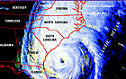
AT 2 PM EDT...1800Z...THE CENTER OF TROPICAL STORM OPHELIA WAS
LOCATED NEAR LATITUDE 31.8 NORTH... LONGITUDE 77.3 WEST OR ABOUT
175 MILES EAST-SOUTHEAST OF CHARLESTON SOUTH CAROLINA AND ABOUT 255
MILES SOUTH-SOUTHWEST OF CAPE HATTERAS NORTH CAROLINA.
OPHELIA IS MOVING TOWARD THE NORTHWEST NEAR 4 MPH AND A SLOW...
GENERALLY NORTHWESTWARD...MOTION IS EXPECTED TODAY AND TONIGHT.
MAXIMUM SUSTAINED WINDS ARE NEAR 70 MPH...WITH HIGHER GUSTS.
OPHELIA HAS THE POTENTIAL TO RESTRENGTHEN INTO A HURRICANE
DURING THE NEXT DAY OR SO.
TROPICAL STORM FORCE WINDS EXTEND OUTWARD UP TO 160 MILES FROM THE
CENTER. SOME OF THE OUTER RAIN BANDS ARE NEAR THE COAST IN THE
WARNING AREA.
THE ESTIMATED MINIMUM CENTRAL PRESSURE IS 989 MB...29.20 INCHES.
REPEATING THE 2 PM EDT POSITION...31.8 N... 77.3 W. MOVEMENT
TOWARD...NORTHWEST NEAR 4 MPH. MAXIMUM SUSTAINED WINDS... 70 MPH.
MINIMUM CENTRAL PRESSURE... 989 MB.
THE NEXT ADVISORY WILL BE ISSUED BY THE NATIONAL HURRICANE CENTER AT
5 PM EDT.
FORECASTER PASCH
TROPICAL STORM OPHELIA INTERMEDIATE ADVISORY NUMBER 25A
NWS TPC/NATIONAL HURRICANE CENTER MIAMI FL
2 PM EDT MON SEP 12 2005
...OPHELIA MOVING SLOWLY NORTHWESTWARD...
A TROPICAL STORM WARNING AND A HURRICANE WATCH ARE IN EFFECT FOR
THE SOUTHEAST COAST OF THE UNITED STATES FROM NORTH OF EDISTO BEACH
SOUTH CAROLINA NORTHEASTWARD TO CAPE LOOKOUT NORTH CAROLINA.
A TROPICAL STORM WARNING MEANS THAT TROPICAL STORM CONDITIONS ARE
EXPECTED WITHIN THE WARNING AREA WITHIN THE NEXT 24 HOURS.
A HURRICANE WATCH MEANS THAT HURRICANE CONDITIONS ARE POSSIBLE
WITHIN THE WATCH AREA...GENERALLY WITHIN 36 HOURS.
WATCHES OR WARNINGS MAY HAVE TO BE EXTENDED NORTHWARD LATER TODAY.
INTERESTS ELSEWHERE IN THE SOUTHEASTERN UNITED STATES COASTAL REGION
SHOULD MONITOR THE PROGRESS OF OPHELIA.
FOR STORM INFORMATION SPECIFIC TO YOUR AREA...INCLUDING POSSIBLE
INLAND WATCHES AND WARNINGS...PLEASE MONITOR PRODUCTS ISSUED
BY YOUR LOCAL WEATHER OFFICE.
AT 2 PM EDT...1800Z...THE CENTER OF TROPICAL STORM OPHELIA WAS
LOCATED NEAR LATITUDE 31.8 NORTH... LONGITUDE 77.3 WEST OR ABOUT
175 MILES EAST-SOUTHEAST OF CHARLESTON SOUTH CAROLINA AND ABOUT 255
MILES SOUTH-SOUTHWEST OF CAPE HATTERAS NORTH CAROLINA.
OPHELIA IS MOVING TOWARD THE NORTHWEST NEAR 4 MPH AND A SLOW...
GENERALLY NORTHWESTWARD...MOTION IS EXPECTED TODAY AND TONIGHT.
MAXIMUM SUSTAINED WINDS ARE NEAR 70 MPH...WITH HIGHER GUSTS.
OPHELIA HAS THE POTENTIAL TO RESTRENGTHEN INTO A HURRICANE
DURING THE NEXT DAY OR SO.
TROPICAL STORM FORCE WINDS EXTEND OUTWARD UP TO 160 MILES FROM THE
CENTER. SOME OF THE OUTER RAIN BANDS ARE NEAR THE COAST IN THE
WARNING AREA.
THE ESTIMATED MINIMUM CENTRAL PRESSURE IS 989 MB...29.20 INCHES.
REPEATING THE 2 PM EDT POSITION...31.8 N... 77.3 W. MOVEMENT
TOWARD...NORTHWEST NEAR 4 MPH. MAXIMUM SUSTAINED WINDS... 70 MPH.
MINIMUM CENTRAL PRESSURE... 989 MB.
THE NEXT ADVISORY WILL BE ISSUED BY THE NATIONAL HURRICANE CENTER AT
5 PM EDT.
FORECASTER PASCH
0 likes
#neversummer


-
BensonTCwatcher

- Category 5

- Posts: 1050
- Joined: Sat Aug 28, 2004 10:11 pm
- Location: Southport NC
Definiately more movement that we have seen in while. I agree. it appears to be crossing the 12 forecast point. If this speed keeps up, it make landfall late tonight. We have seen this kind of start/stop before, but I think the difference now is the weakening of the ridge over the eastern us and the movement and building of the mid-atalnitc ridge west.
0 likes
-
BensonTCwatcher
- Category 5
- Posts: 1050
- Joined: Sat Aug 28, 2004 10:11 pm
- Location: Southport NC
-
GaryOBX
- Tropical Depression

- Posts: 90
- Joined: Wed Sep 03, 2003 2:33 pm
- Location: Outer Banks, NC
- Contact:
At 11:00 AM, Ophelia was at 31.6N 76.8W, with a +12HR forecast position of 31.8N 77.4W
At 2:00 PM, Ophelia is at 31.8N 77.3W
So basically, she's 9 hours faster than forecast.
At 2:00 PM, Ophelia is at 31.8N 77.3W
So basically, she's 9 hours faster than forecast.
Last edited by GaryOBX on Mon Sep 12, 2005 1:03 pm, edited 1 time in total.
0 likes
-
hurricanefreak1988
- Category 3

- Posts: 869
- Joined: Thu Jul 22, 2004 10:13 pm
- Location: Fayetteville, NC
- Contact:
-
BensonTCwatcher
- Category 5
- Posts: 1050
- Joined: Sat Aug 28, 2004 10:11 pm
- Location: Southport NC
-
txwatcher91
- Category 5
- Posts: 1498
- Joined: Tue Aug 02, 2005 2:29 pm
They have her direction listed officially as NW, but seems more wnw to me. They are still insisting the northward trend is going to happen and it isn't supposed to make landfall in SC (we aren't even in the "cone" any longer), but I am beginning to wonder if it is going to make the turn towards the north before it makes landfall. Outer rainbands are almost coming on shore.
0 likes
-
BensonTCwatcher
- Category 5
- Posts: 1050
- Joined: Sat Aug 28, 2004 10:11 pm
- Location: Southport NC
txwatcher91 wrote:Didn't want to start a new thread on this so, does anybody have some good SST maps for where Ophelia is at now?
Try here, you can click on the bouy "behind" her and see about 78 deg F water, and around 81 deg out in front
http://www.ndbc.noaa.gov/Maps/Southeast.shtml
0 likes

Some robust movement going on. The 2PM coordinates show that "O" has moved nearly 30 mi since the 11AM coordinates position. At this latitude, 1 degree is approximately 56 mi. "O" has moved a bit over 0.5 degrees in the WNW direction. With the 3-hr interval between coordinate readings, this translates to closer to 10MPH rather than the reported 4MPH. If this continues, "O" will be putting her significant feeder bands ashore in NESC / SENC in about 6 hrs.
0 likes
-
cycloneye

- Admin

- Posts: 149841
- Age: 69
- Joined: Thu Oct 10, 2002 10:54 am
- Location: San Juan, Puerto Rico
TPNT KGWC 121745
A. TROPICAL STORM OPHELIA (SIXTEEN)
B. 12/1731Z (82)
C. 31.7N/1
D. 77.4W/8
E. THREE/GOES12
F. T3.0/3.5/W1.0/24HRS -12/1731Z-
G. IR/EIR/VIS/MSI
19A/PBO XPSD LLCC/ANMTN. LLCC IS LOCATED 13NM FROM DG GIVING A
DT OF 3.0. FT BASED ON DT. PT AND MET SUPPORT.
AODT: T4.1 (SHEAR)
KAMINSKI
Air Force T numbers 3.0/3/5 are given.
0 likes
Visit the Caribbean-Central America Weather Thread where you can find at first post web cams,radars
and observations from Caribbean basin members Click Here
and observations from Caribbean basin members Click Here
Who is online
Users browsing this forum: No registered users and 461 guests