The Tropical Weather Outlook for August 2nd, 2003 at 11 am EDT
can be found below at http://storm2k.org/Weather-Central/Trop ... ropics.htm
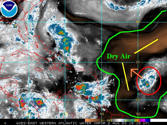
90L maintains some convection ... but the surrounding atmosphere is rather dry at this time.
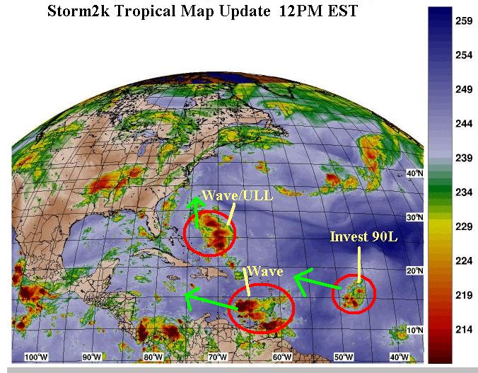
11 AM Storm2k Tropical Weather Outlook
Moderator: S2k Moderators
Forum rules

The posts in this forum are NOT official forecasts and should not be used as such. They are just the opinion of the poster and may or may not be backed by sound meteorological data. They are NOT endorsed by any professional institution or STORM2K. For official information, please refer to products from the National Hurricane Center and National Weather Service.
-
Stormsfury

- Category 5

- Posts: 10549
- Age: 53
- Joined: Wed Feb 05, 2003 6:27 pm
- Location: Summerville, SC
11 AM Storm2k Tropical Weather Outlook
Last edited by Stormsfury on Sat Aug 02, 2003 11:58 am, edited 1 time in total.
0 likes
-
chadtm80
-
vbhoutex

- Storm2k Executive

- Posts: 29150
- Age: 74
- Joined: Wed Oct 09, 2002 11:31 pm
- Location: Cypress, TX
- Contact:
Looks like the dry air from the SAL did finally get to 90L. It will be struggling for at least the next 48 hours to maintain its' identity. I thought I saw some low level turning this am on the sat loops, but it could have been at mid level instead. Lately though it is very hard to detect if there is any. We may have an open wave now.
I'm more impressed with the wave passing through the islands just off the N Coast of SA. It has maintained and increased its' convection even the face of strong shear from the SW. We may need to keep an eye on this one even though it is skirting the coast.
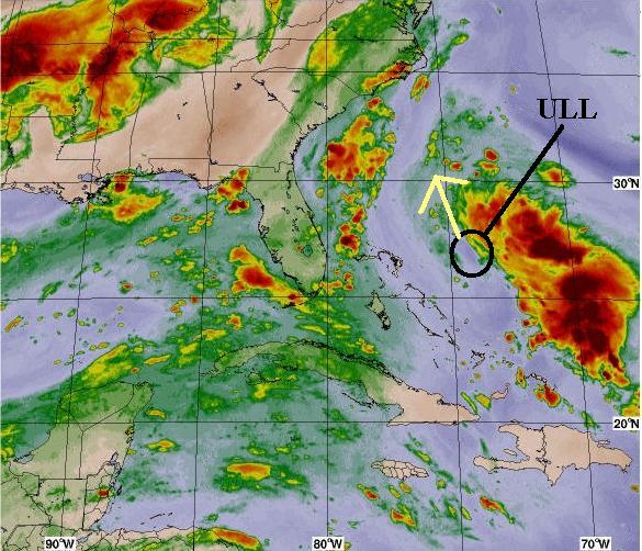
Even though Joe B seems to think the ULL and TW E of the Bahamas is going to do something this weekend tropically and threaten the E coast I must respectfully disagree. If it does anything it is going to be riding the W side of the ridge and trough off the E coast back NE to sea, imo.
I'm more impressed with the wave passing through the islands just off the N Coast of SA. It has maintained and increased its' convection even the face of strong shear from the SW. We may need to keep an eye on this one even though it is skirting the coast.
Even though Joe B seems to think the ULL and TW E of the Bahamas is going to do something this weekend tropically and threaten the E coast I must respectfully disagree. If it does anything it is going to be riding the W side of the ridge and trough off the E coast back NE to sea, imo.
0 likes
Skywarn, C.E.R.T.
Please click below to donate to STORM2K to help with the expenses of keeping the site going:

Please click below to donate to STORM2K to help with the expenses of keeping the site going:
-
Stormsfury
- Category 5
- Posts: 10549
- Age: 53
- Joined: Wed Feb 05, 2003 6:27 pm
- Location: Summerville, SC
vbhoutex wrote:Looks like the dry air from the SAL did finally get to 90L. It will be struggling for at least the next 48 hours to maintain its' identity. I thought I saw some low level turning this am on the sat loops, but it could have been at mid level instead. Lately though it is very hard to detect if there is any. We may have an open wave now.
I'm more impressed with the wave passing through the islands just off the N Coast of SA. It has maintained and increased its' convection even the face of strong shear from the SW. We may need to keep an eye on this one even though it is skirting the coast.
Even though Joe B seems to think the ULL and TW E of the Bahamas is going to do something this weekend tropically and threaten the E coast I must respectfully disagree. If it does anything it is going to be riding the W side of the ridge and trough off the E coast back NE to sea, imo.
I agree, VB, in the regards to the ULL/TW couplet ... notice the winds are southerly along the Southeast Coast and that current trough is only going to be reinforced by another s/w digging across the East.
0 likes
-
chadtm80
I'm more impressed with the wave passing through the islands just off the N Coast of SA. It has maintained and increased its' convection even the face of strong shear from the SW. We may need to keep an eye on this one even though it is skirting the coast.
I wonder if the TWO will mention it
http://www.ssd.noaa.gov/PS/TROP/DATA/RT/WATL/IR4/20.jpg
0 likes
-
chadtm80
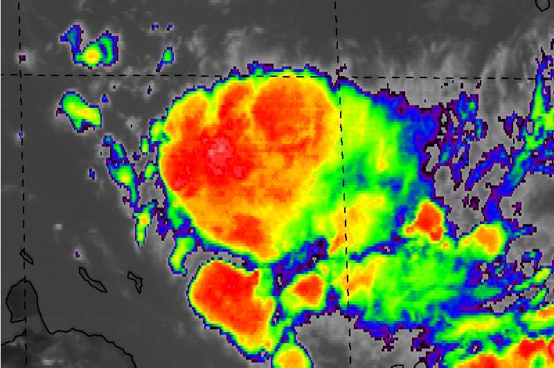
Here is a pic I saved at 2pm zoomed in on the E. Carib storm.. Nice ball of convections
 http://storm2k.org/uploaded_images/CHAD/Image10.JPG
0 likes
-
southerngale

- Retired Staff

- Posts: 27418
- Joined: Thu Oct 10, 2002 1:27 am
- Location: Southeast Texas (Beaumont area)
 my Cowboys
-
Guest
-
Stormsfury
- Category 5
- Posts: 10549
- Age: 53
- Joined: Wed Feb 05, 2003 6:27 pm
- Location: Summerville, SC
Who is online
Users browsing this forum: No registered users and 139 guests