INVEST in EPAC??
Moderator: S2k Moderators
Forum rules

The posts in this forum are NOT official forecasts and should not be used as such. They are just the opinion of the poster and may or may not be backed by sound meteorological data. They are NOT endorsed by any professional institution or STORM2K. For official information, please refer to products from the National Hurricane Center and National Weather Service.
-
Epsilon_Fan

- Category 1

- Posts: 353
- Joined: Fri Jan 13, 2006 1:03 pm
- Location: Charleston, SC
INVEST in EPAC??
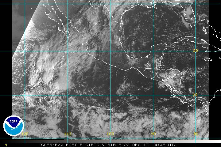
I could swear that there was a twist to that blob that has just entered the EPAC off Panama... what do you think? or is this more grasping for straws?
Last edited by Epsilon_Fan on Sat May 06, 2006 12:32 am, edited 1 time in total.
0 likes
-
CHRISTY

-
Weatherfreak000
-
CHRISTY
Here's a 48hr loop of Real-Time formation probability....
http://www.ssd.noaa.gov/PS/TROP/DATA/gparm/probability_loop.html
http://www.ssd.noaa.gov/PS/TROP/DATA/gparm/probability_loop.html
0 likes
-
Epsilon_Fan
- Category 1
- Posts: 353
- Joined: Fri Jan 13, 2006 1:03 pm
- Location: Charleston, SC

Weatherfreak000 wrote:Louisiana is under the gen probs lol.
Shows this purple means alot right?
It is kind of amusing as the product description says that "Areas that are 100% over land" are screened out. I guess Lake Ponchratrain is what keeps that box from being screened out
0 likes

-
CHRISTY
Re: Something near Panama.. EPAC
i think so...Epsilon_Fan wrote:I could swear that there was a twist to that blob that has just entered the EPAC off Panama... what do you think? or is this more grasping for straws?
0 likes
-
Epsilon_Fan
- Category 1
- Posts: 353
- Joined: Fri Jan 13, 2006 1:03 pm
- Location: Charleston, SC
BROAD UPPER TROUGH LIES OVER THE NW PART OF THE AREA WITH
PARTIAL SPLIT FLOW STILL IN COMMAND BETWEEN THE WRN US COAST AND
150W. THE SUBTROPICAL JET EXTENDS FROM 12N140W NE TO 27N110W
WITH THE FLOW BEING SQUEEZED AND ACCELERATED NEAR THE BAJA
PENINSULA AS A SHARP UPPER TROUGH DROPS S FROM CALIFORNIA...
TOWARDS AN UPPER HIGH CENTERED NEAR 15N110W. MAXIMUM 300 MB
WINDS IN THE JET CORE ARE 75 KT WHERE THE JET COMES INTO SRN
CALIFORNIA. UPPER DIFFLUENCE IS OCCURRING ON THE W SIDE OF THE
UPPER HIGH AND IS ENHANCING DEEP CONVECTION NEAR THE ITCZ E OF
133W. AN OMEGA BLOCK IS EXPECTED TO DEVELOP OVER THE AREA BY MON
OR TUE AS TWO MID/UPPER LOWS STALL OVER THE BAJA PENINSULA AND
NEAR 28N145W...WITH A RIDGE IN THE MIDDLE ALONG 130W.
E OF 110W...
MOSTLY VARIABLE UPPER LEVEL FLOW EXTENDS ACROSS THE PACIFIC E OF
110W WITH THE MID-LATITUDE WLYS LIMITED TO N OF 13N. A WEAK
UPPER HIGH IS CENTERED S OF THE GULF OF TEHUANTEPEC NEAR 10N94W
WITH ONLY WEAKLY SUBSIDENT AIR IN THE REGION. LOW-LEVEL
CONVERGENCE ALONG THE ITCZ IS STILL STRONG ENOUGH AND MOISTURE
STILL HIGH ENOUGH TO PRODUCE SCATTERED CONVECTIVE ACTIVITY ALONG
THE ITCZ E OF 93W TO THE COAST OF COLOMBIA. AN INVERTED UPPER
TROUGH IS ALONG 95W S OF 5N WITH STRONG SUBSIDENCE LYING UP TO
750 NM TO THE E. FARTHER E...A MID/UPPER RIDGE AXIS EXTENDS FROM
NRN VENEZUELA TO JUST OFF THE PACIFIC COAST OF COLOMBIA...
ENHANCING ITCZ CONVECTION AND SPREADING THE CIRRUS NWD ACROSS
PANAMA/COSTA RICA.
0 likes
boca wrote:What does those different colors represent on that map? ex purple and blue
The scale is the % chance of tropical cyclone formation. So, the purple is 0.1%, then (darker) blue is 0.2% and so on. And yes, this means that the scale maxxes out at 12%.
This link, http://ams.confex.com/ams/26HURR/techpr ... _75155.htm ,
gives a little more insight on the product. In the recorded presentation (which takes a special browser plug-in to play), Demaria explains the reason why the probability maxxes out there is because the area for one block is so small.
0 likes


-
Matt-hurricanewatcher
mobilebay wrote:Matt-hurricanewatcher wrote:Nothing will form...
famous last words.
Just let me say that I don't expect anything to develop on earth in the next 7 to 10 days.
Atlantic NO development next 10 to 15 days
Eastern Pacific NO development next 10 days
Central Pacific NO development Next 20 days
Western Pacific NO Development through 7 to 10 days
South Indian ocean No development
South Pacific NO development
I expect the next cyclone to form about 12 days from now.
0 likes
-
CHRISTY

-
MiamiensisWx
-
MiamiensisWx
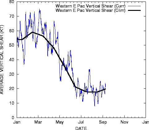
Right now, the system just south of 10N and near 120W is under high shear right now. Shear is decreasing slightly ahead of it, but it is under 40KT of shear now, even though the environment is moist.
One interesting thing to note, though, is that this appears to be a true tropical wave system, rather than convection along a trough axis wave. See the infra-red loop here. I do see some hints of a circulation as well. THIS may be something to watch. Who agrees?
One interesting thing to note, though, is that this appears to be a true tropical wave system, rather than convection along a trough axis wave. See the infra-red loop here. I do see some hints of a circulation as well. THIS may be something to watch. Who agrees?
0 likes
Who is online
Users browsing this forum: Google [Bot], Team Ghost and 86 guests