Outlook
Storm2k 5pm Outlook
Moderator: S2k Moderators
Forum rules
The posts in this forum are NOT official forecasts and should not be used as such. They are just the opinion of the poster and may or may not be backed by sound meteorological data. They are NOT endorsed by any professional institution or STORM2K. For official information, please refer to products from the National Hurricane Center and National Weather Service.
-
chadtm80
Storm2k 5pm Outlook
Last edited by chadtm80 on Thu Jun 26, 2003 7:36 pm, edited 2 times in total.
0 likes
- GulfBreezer
- Category 5

- Posts: 2230
- Joined: Wed Oct 09, 2002 8:58 pm
- Location: Gulf Breeze Fl
- Contact:
-
Rainband
- wxman57
- Moderator-Pro Met

- Posts: 23080
- Age: 68
- Joined: Sat Jun 21, 2003 8:06 pm
- Location: Houston, TX (southwest)
Can't See Any Circulation From Here
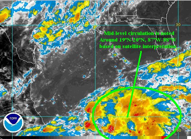
I've been looping the satellite and I think you may be seeing an illusion of a circulation based on cirrus movement. Look like quite strong southwest shear through the western Caribbean. Actually, the disturbance looks more ominous on still images than in the loop (where the shear is so evident). There's no central point of convection, it's just firing here and there. Since it appears the GFS was incorrect about the decreasing shear, I drop my estimate of development potential to 10-15% again. Can't rule it out, but that shear needs to drop off a lot. Probably just a rain-maker for Florida and maybe the southeast U.S. Not much to push it westward.
0 likes
- mf_dolphin
- Category 5

- Posts: 17758
- Age: 69
- Joined: Tue Oct 08, 2002 2:05 pm
- Location: St Petersburg, FL
- Contact:
Who is online
Users browsing this forum: pepecool20 and 69 guests

