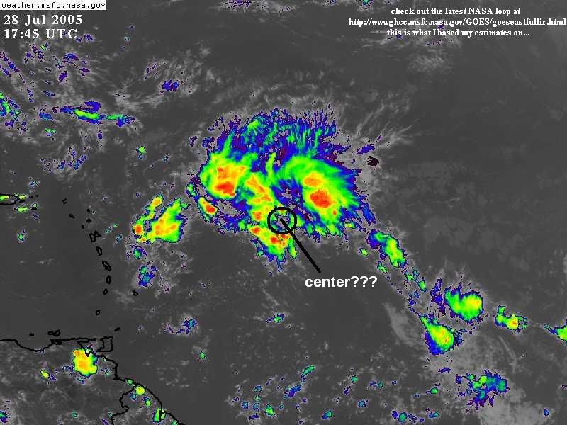
This system has seen multiple centers thru it's life.So the question is where it is right now.
I see a surface reflection around 17n-55w.Or maybe is a Mid-Level Circulation.I would lie to see those great pics that wxman57 brings a lot.
What about you where do you see the center?
Where is the center of 92L?
Moderator: S2k Moderators
Forum rules

The posts in this forum are NOT official forecasts and should not be used as such. They are just the opinion of the poster and may or may not be backed by sound meteorological data. They are NOT endorsed by any professional institution or STORM2K. For official information, please refer to products from the National Hurricane Center and National Weather Service.
-
cycloneye

- Admin

- Posts: 148853
- Age: 69
- Joined: Thu Oct 10, 2002 10:54 am
- Location: San Juan, Puerto Rico
Where is the center of 92L?
0 likes
Visit the Caribbean-Central America Weather Thread where you can find at first post web cams,radars
and observations from Caribbean basin members Click Here
and observations from Caribbean basin members Click Here
-
Trader Ron

- S2K Supporter

- Posts: 928
- Joined: Tue Jul 22, 2003 7:25 pm
- Location: Naples,Fl
- Contact:

-
cycloneye
- Admin
- Posts: 148853
- Age: 69
- Joined: Thu Oct 10, 2002 10:54 am
- Location: San Juan, Puerto Rico
After looking more closely I see something trying to spin around 18n-52w in the convection.
0 likes
Visit the Caribbean-Central America Weather Thread where you can find at first post web cams,radars
and observations from Caribbean basin members Click Here
and observations from Caribbean basin members Click Here
-
Hurricaneman

- Category 5

- Posts: 7404
- Age: 45
- Joined: Tue Aug 31, 2004 3:24 pm
- Location: central florida


-
Hurricaneman
- Category 5
- Posts: 7404
- Age: 45
- Joined: Tue Aug 31, 2004 3:24 pm
- Location: central florida
-
cycloneye
- Admin
- Posts: 148853
- Age: 69
- Joined: Thu Oct 10, 2002 10:54 am
- Location: San Juan, Puerto Rico
Any more opinions about where the center of 92L is?
0 likes
Visit the Caribbean-Central America Weather Thread where you can find at first post web cams,radars
and observations from Caribbean basin members Click Here
and observations from Caribbean basin members Click Here
-
jasons2k

- Storm2k Executive
- Posts: 8288
- Age: 52
- Joined: Wed Jul 06, 2005 12:32 pm
- Location: The Woodlands, TX
cycloneye wrote:Any more opinions about where the center of 92L is?
Not me! I see one small LLC well removed from the convection to the SW and it looks like a couple of mid-level circulations within and around the convection. If I had to pinpoint anything I might as well be throwing darts at the screen - hehe.
0 likes
-
Matt-hurricanewatcher
The center is reforming under the convection. 18 north/52 west ploted by the models. There is nice curving with convection all around it. I would not be suprized to see a depression develop rather soon.
http://www.cira.colostate.edu/ramm/rmsd ... PICAL.html
DISCLAIMER...NUMERICAL MODELS ARE SUBJECT TO LARGE ERRORS.
PLEASE REFER TO TPC/NHC OFFICIAL FORECASTS FOR TROPICAL CYCLONES.
.....THE FOLLOWING IS A TEST MESSAGE.....
NATIONAL HURRICANE CENTER NORTH ATLANTIC OBJECTIVE AIDS FOR
TROPICAL DEPRESSION INVEST (AL922005) ON 20050728 1200 UTC
...00 HRS... ...12 HRS... ...24 HRS... ...36 HRS...
050728 1200 050729 0000 050729 1200 050730 0000
LAT LON LAT LON LAT LON LAT LON
BAMD 18.2N 52.4W 19.6N 54.6W 21.0N 56.3W 22.3N 57.8W
BAMM 18.2N 52.4W 19.4N 55.3W 20.5N 57.9W 21.7N 60.2W
A98E 18.2N 52.4W 19.0N 56.2W 20.5N 59.1W 22.5N 61.1W
LBAR 18.2N 52.4W 19.6N 54.9W 20.8N 57.5W 21.8N 59.6W
SHIP 25KTS 33KTS 41KTS 49KTS
DSHP 25KTS 33KTS 41KTS 49KTS
...48 HRS... ...72 HRS... ...96 HRS... ..120 HRS...
050730 1200 050731 1200 050801 1200 050802 1200
LAT LON LAT LON LAT LON LAT LON
BAMD 23.5N 59.3W 24.6N 61.6W 24.2N 63.5W 23.8N 65.0W
BAMM 22.9N 62.3W 24.6N 65.5W 24.8N 68.1W 24.8N 70.8W
A98E 24.8N 62.6W 28.8N 66.3W 30.8N 68.2W 31.2N 67.4W
LBAR 22.6N 61.4W 23.1N 64.0W 23.2N 65.8W 23.5N 66.7W
SHIP 55KTS 63KTS 67KTS 70KTS
DSHP 55KTS 63KTS 67KTS 70KTS
...INITIAL CONDITIONS...
LATCUR = 18.2N LONCUR = 52.4W DIRCUR = 295DEG SPDCUR = 18KT
LATM12 = 15.6N LONM12 = 49.9W DIRM12 = 333DEG SPDM12 = 19KT
LATM24 = 12.0N LONM24 = 47.7W
WNDCUR = 25KT RMAXWD = 45NM WNDM12 = 20KT
CENPRS = 1012MB OUTPRS = 1014MB OUTRAD = 150NM SDEPTH = D
RD34NE = 0NM RD34SE = 0NM RD34SW = 0NM RD34NW = 0NM
.....THE ABOVE HAS BEEN A TEST MESSAGE.....
0 likes
-
mike18xx
Examining visibles, I don't see it happening at the surface, and I've never seen a system shaped like this one do that before. What should happen as that any so-called "new centers" on the SAL boundary will collapse in a series of outflow arcs to the northwest; these will race around and reinforce the real center:The center is reforming under the convection. 18 north/52 west ploted by the models.

Last edited by mike18xx on Thu Jul 28, 2005 2:03 pm, edited 2 times in total.
0 likes

-
wxwatcher91

- Category 5
- Posts: 1606
- Joined: Wed Jul 06, 2005 2:43 pm
- Location: Keene, NH
- Contact:
000
WHXX01 KWBC 281859
CHGHUR
DISCLAIMER...NUMERICAL MODELS ARE SUBJECT TO LARGE ERRORS.
PLEASE REFER TO TPC/NHC OFFICIAL FORECASTS FOR TROPICAL CYCLONES.
.....THE FOLLOWING IS A TEST MESSAGE.....
NATIONAL HURRICANE CENTER NORTH ATLANTIC OBJECTIVE AIDS FOR
TROPICAL DEPRESSION INVEST (AL922005) ON 20050728 1800 UTC
...00 HRS... ...12 HRS... ...24 HRS... ...36 HRS...
050728 1800 050729 0600 050729 1800 050730 0600
LAT LON LAT LON LAT LON LAT LON
BAMD 18.4N 53.4W 19.6N 55.7W 20.9N 57.7W 22.0N 59.6W
BAMM 18.4N 53.4W 19.5N 56.1W 20.8N 58.6W 21.9N 60.6W
A98E 18.4N 53.4W 18.9N 56.0W 20.0N 58.5W 21.5N 60.7W
LBAR 18.4N 53.4W 19.4N 55.7W 20.4N 57.8W 21.1N 59.7W
SHIP 25KTS 33KTS 41KTS 48KTS
DSHP 25KTS 33KTS 41KTS 48KTS
...48 HRS... ...72 HRS... ...96 HRS... ..120 HRS...
050730 1800 050731 1800 050801 1800 050802 1800
LAT LON LAT LON LAT LON LAT LON
BAMD 23.0N 61.4W 24.3N 64.3W 24.7N 66.4W 24.9N 68.4W
BAMM 23.0N 62.6W 24.4N 65.6W 24.8N 68.0W 25.1N 70.4W
A98E 23.2N 63.1W 25.9N 67.3W 27.2N 70.2W 27.3N 71.5W
LBAR 21.8N 61.4W 22.4N 64.3W 22.9N 66.2W 23.7N 67.4W
SHIP 55KTS 63KTS 66KTS 70KTS
DSHP 55KTS 63KTS 66KTS 70KTS
...INITIAL CONDITIONS...
LATCUR = 18.4N LONCUR = 53.4W DIRCUR = 290DEG SPDCUR = 13KT
LATM12 = 17.1N LONM12 = 50.9W DIRM12 = 318DEG SPDM12 = 16KT
LATM24 = 13.8N LONM24 = 49.1W
WNDCUR = 25KT RMAXWD = 45NM WNDM12 = 20KT
CENPRS = 1012MB OUTPRS = 1014MB OUTRAD = 150NM SDEPTH = D
RD34NE = 0NM RD34SE = 0NM RD34SW = 0NM RD34NW = 0NM
.....THE ABOVE HAS BEEN A TEST MESSAGE.....
here's my estimate... may be way off but who knows...
0 likes
-
WeatherEmperor
- S2K Supporter
- Posts: 4806
- Age: 41
- Joined: Thu Sep 04, 2003 2:54 pm
- Location: South Florida
wxwatcher91 wrote:000
WHXX01 KWBC 281859
CHGHUR
DISCLAIMER...NUMERICAL MODELS ARE SUBJECT TO LARGE ERRORS.
PLEASE REFER TO TPC/NHC OFFICIAL FORECASTS FOR TROPICAL CYCLONES.
.....THE FOLLOWING IS A TEST MESSAGE.....
NATIONAL HURRICANE CENTER NORTH ATLANTIC OBJECTIVE AIDS FOR
TROPICAL DEPRESSION INVEST (AL922005) ON 20050728 1800 UTC
...00 HRS... ...12 HRS... ...24 HRS... ...36 HRS...
050728 1800 050729 0600 050729 1800 050730 0600
LAT LON LAT LON LAT LON LAT LON
BAMD 18.4N 53.4W 19.6N 55.7W 20.9N 57.7W 22.0N 59.6W
BAMM 18.4N 53.4W 19.5N 56.1W 20.8N 58.6W 21.9N 60.6W
A98E 18.4N 53.4W 18.9N 56.0W 20.0N 58.5W 21.5N 60.7W
LBAR 18.4N 53.4W 19.4N 55.7W 20.4N 57.8W 21.1N 59.7W
SHIP 25KTS 33KTS 41KTS 48KTS
DSHP 25KTS 33KTS 41KTS 48KTS
...48 HRS... ...72 HRS... ...96 HRS... ..120 HRS...
050730 1800 050731 1800 050801 1800 050802 1800
LAT LON LAT LON LAT LON LAT LON
BAMD 23.0N 61.4W 24.3N 64.3W 24.7N 66.4W 24.9N 68.4W
BAMM 23.0N 62.6W 24.4N 65.6W 24.8N 68.0W 25.1N 70.4W
A98E 23.2N 63.1W 25.9N 67.3W 27.2N 70.2W 27.3N 71.5W
LBAR 21.8N 61.4W 22.4N 64.3W 22.9N 66.2W 23.7N 67.4W
SHIP 55KTS 63KTS 66KTS 70KTS
DSHP 55KTS 63KTS 66KTS 70KTS
...INITIAL CONDITIONS...
LATCUR = 18.4N LONCUR = 53.4W DIRCUR = 290DEG SPDCUR = 13KT
LATM12 = 17.1N LONM12 = 50.9W DIRM12 = 318DEG SPDM12 = 16KT
LATM24 = 13.8N LONM24 = 49.1W
WNDCUR = 25KT RMAXWD = 45NM WNDM12 = 20KT
CENPRS = 1012MB OUTPRS = 1014MB OUTRAD = 150NM SDEPTH = D
RD34NE = 0NM RD34SE = 0NM RD34SW = 0NM RD34NW = 0NM
.....THE ABOVE HAS BEEN A TEST MESSAGE.....
here's my estimate... may be way off but who knows...
that is very close to where I think the center is myself.
<RICKY>
0 likes
-
mike18xx
Geez, people; watch the VISIBLES. IR is total crappola for trying to spot LLCs.
http://www.ghcc.msfc.nasa.gov/GOES/goeseasthurr.html
The actual center is blatantly obvious once you crank up the animation speed.
http://www.ghcc.msfc.nasa.gov/GOES/goeseasthurr.html
The actual center is blatantly obvious once you crank up the animation speed.
0 likes


-
jhamps10
Sanibel wrote:The surface center is where Mike put it in his green circle.
There could be a second center trying to form back up in the deeper convection...
Looks like to me that the center is in a deep area of convection around 20N-49.2W. I may be totally off track here, but that's where it looks to me.
0 likes
-
Weatherboy1

- Category 5
- Posts: 1190
- Age: 50
- Joined: Mon Jul 05, 2004 1:50 pm
- Location: Jupiter/Sarasota, FL
I believe the model initialization is the correct "cent
earlier (several hours ago), it appeared that the main center was farther E, as someone in this thread indicated. But now, I believe, this wave is consolidating itself around 18.5N 53.5W or so. In the last few satelite frames, there has been more "popcorn-looking" convection popping around that area, vs. just the high-level clouds we saw earlier. And some low-level cloud bands appear to be forming around that general area.
That's my two cents, anyway
-Mike
That's my two cents, anyway
-Mike
0 likes
Who is online
Users browsing this forum: No registered users and 60 guests