Can it pull an Opal?
Moderator: S2k Moderators
Forum rules

The posts in this forum are NOT official forecasts and should not be used as such. They are just the opinion of the poster and may or may not be backed by sound meteorological data. They are NOT endorsed by any professional institution or STORM2K. For official information, please refer to products from the National Hurricane Center and National Weather Service.

Can it pull an Opal?
I am hoping and praying that this thing pulls an opal...ie, weaken to a 3 just before landfall
0 likes
-
manofsteele79
- Tropical Depression

- Posts: 63
- Joined: Thu Sep 09, 2004 9:28 pm
- Location: Hattiesburg, MS (Robertsdale, AL)

-
manofsteele79
- Tropical Depression
- Posts: 63
- Joined: Thu Sep 09, 2004 9:28 pm
- Location: Hattiesburg, MS (Robertsdale, AL)

djtil wrote:lili, a borderline cat 5 storm wasnt organized?
what all 3 of those have in common is that they were not forecast to significantly weaken before landfall and they did....
From what I understand Lili didnt even have hurricane force winds in here SW quad. Thats HIGHLY unorganized for a Cat 4.
0 likes
I don't think we'll pull an Opal or Lili (or even Ivan), but some weakening is certainly possible if not probable before landfall with slightly cooler and shallower waters. However, relatively quick movement should prevent much I would think.
Still, this wil almost certainly come in at least as a strong cat 3 or higher unless something unforseen to this point happens.
Still, this wil almost certainly come in at least as a strong cat 3 or higher unless something unforseen to this point happens.
0 likes

-
ALhurricane

- Professional-Met

- Posts: 452
- Joined: Wed Jan 08, 2003 12:46 pm
- Location: Daphne, AL
Actually, the water temperatures are actually running at 84-86 degrees off the AL and NW FL coasts. I am not sure where the talk of cooler waters has come from.
http://www.osdpd.noaa.gov/PSB/EPS/SST/d ... mex.cf.gif
http://www.osdpd.noaa.gov/PSB/EPS/SST/d ... mex.cf.gif
0 likes
-
Derek Ortt
-
HurricaneBill
- Category 5

- Posts: 3420
- Joined: Sun Apr 11, 2004 5:51 pm
- Location: East Longmeadow, MA, USA
-
THead
- S2K Supporter

- Posts: 790
- Joined: Mon Aug 30, 2004 5:09 pm
- Location: Lauderhill, Fla./Jefferson, Ga.
Lili was 938 MB 140 MPH at 25.9N 90W, and 942 MB 145 MPH at 27.2N 90.6W, I don't know what you call organized or pretty or what, but any storm capable of generating those kind of numbers is no slouch.
http://www.hurricanetrack.com/JavaHist//
http://www.hurricanetrack.com/JavaHist//
0 likes
-
Tri-State_1925

- Category 1

- Posts: 341
- Joined: Fri Aug 13, 2004 11:16 am
- Location: Worcester Hills, MA
ALhurricane wrote:Actually, the water temperatures are actually running at 84-86 degrees off the AL and NW FL coasts. I am not sure where the talk of cooler waters has come from.
http://www.osdpd.noaa.gov/PSB/EPS/SST/d ... mex.cf.gif
TWC did a lot of on-camera mentioning of relatively cooler waters at the costline that was partly responsible for Opal's weakening...whether it's true or not
Doesn't look like that's the case here...
0 likes
-
Derek Ortt
-
THead
- S2K Supporter
- Posts: 790
- Joined: Mon Aug 30, 2004 5:09 pm
- Location: Lauderhill, Fla./Jefferson, Ga.
A link to some great pics of Lili
http://www.atmos.umd.edu/~stevenb/hurr/ ... index.html
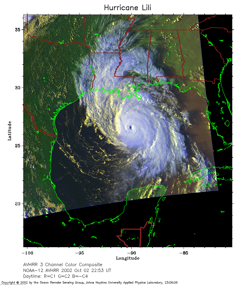
She's not looking too shabby in this one:
http://www.atmos.umd.edu/~stevenb/hurr/ ... 2_2253.png
Just wishful thinking on my part that Dennis does the same as Lili, and dies.
http://www.atmos.umd.edu/~stevenb/hurr/ ... index.html
She's not looking too shabby in this one:
http://www.atmos.umd.edu/~stevenb/hurr/ ... 2_2253.png
Just wishful thinking on my part that Dennis does the same as Lili, and dies.
0 likes
-
HurricaneBill
- Category 5
- Posts: 3420
- Joined: Sun Apr 11, 2004 5:51 pm
- Location: East Longmeadow, MA, USA
Derek Ortt wrote:structurally, Lili was the most pathetic looking cat 4 hurricane in history. It only received 15-20KT of shear, but that destroyed the circulation. It was about as structurally organized at landfall as it was at peak intensity.
Dennis is far better organized
What about Karl from last year at peak intensity?
0 likes
Who is online
Users browsing this forum: hcane27 and 156 guests