The waiting game continues zzzzzzzzz

This is the general tropical discussion area. Anyone can take their shot at predicting a storms path.

Moderator: S2k Moderators

Forum rules

The posts in this forum are NOT official forecasts and should not be used as such. They are just the opinion of the poster and may or may not be backed by sound meteorological data. They are NOT endorsed by any professional institution or STORM2K. For official information, please refer to products from the National Hurricane Center and National Weather Service.

Help Support Storm2K
Message
Author
User avatar
cycloneye
Admin
Admin
Posts: 148503
Age: 69
Joined: Thu Oct 10, 2002 10:54 am
Location: San Juan, Puerto Rico

The waiting game continues zzzzzzzzz

#1 Postby cycloneye » Sat Jun 18, 2005 10:17 am

461
ABNT20 KNHC 181454
TWOAT
TROPICAL WEATHER OUTLOOK
NWS TPC/NATIONAL HURRICANE CENTER MIAMI FL
1130 AM EDT SAT JUN 18 2005

FOR THE NORTH ATLANTIC...CARIBBEAN SEA AND THE GULF OF MEXICO...

A WEAK AREA OF LOW PRESSURE IS LOCATED ABOUT 300 MILES EAST OF
BERMUDA. THIS SYSTEM IS EXPECTED TO CONTINUE MOVING NORTHEASTWARD
OVER COOL WATERS AND TROPICAL STORM FORMATION IS NOT EXPECTED HERE
OR ELSEWHERE THROUGH SUNDAY.

FORECASTER FRANKLIN

$$


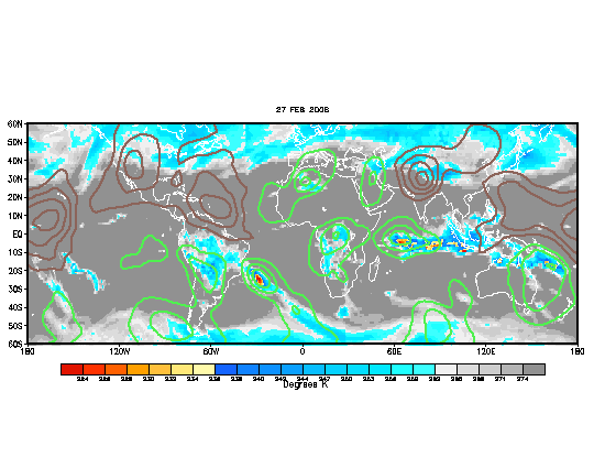
I say that we wont see the second named storm until sometime in early to mid july as the dry phase or not favorable MJO (Madden Julian Occillation) is now in place in the Atlantic basin denoted by the brown lines at grafic.However this factor is not seen as a big one as there haved been mix signals about it's effects in the past.But the bottomline regardless of the MJO is that the waiting game continues but for how long?
Image
0 likes   
Visit the Caribbean-Central America Weather Thread where you can find at first post web cams,radars
and observations from Caribbean basin members Click Here

Return to “Talkin' Tropics”

Who is online

Users browsing this forum: No registered users and 616 guests