Personal Disclaimer: All official products are located at http://www.nhc.noaa.gov/ . For warning and evacuation information, please turn to your local NWS office website via a link at http://www.srh.noaa.gov/ or tune in to your local television station.
Graphic Disclaimer: The Graphic provided in this forecast is not official in any way and not endorsed by S2K, NWS, or NOAA.
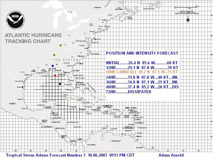
Arlene has steadily intensified throughout the day, dropping to 990 mb in the latest reconnaissance aircraft reports. She has also become much better organized with storms around the center and winds near 70 MPH. Arlene has also accelerated in forward speed and will reach the coastline sometime tomorrow afternoon, after taking directional jogs west of north. Based on this information, my forecast has been bumped up significantly. I am now expecting Arlene to be 75 KT at landfall, near Gulf Shores, AL, and I make that forecast with slight skepticism that it could also be 70 KT. Afterwards, Arlene should steadily weaken as she moves north into Alabama and the Applachians. For right now, I do not expect any rapid intensification that will take it beyond 75 KT. To have that occur, Arlene would need to quickly organize her storms completely around the center with significant outflow, and that looks unlikely.
From Arlene, expect heavy rainfall with locally up to 8" possible in some locations, especially north and east of the center. High winds could carry excess Ivan debris, especially along the beach, so be mindful of this, and expect a storm surge of at least 5 feet near and just to the east of the center. Keep in tune to your local television news station for the latest evacuation and advisory information for your area.
The following is my personal forecast graphic of Arlene: