http://www.ssd.noaa.gov/PS/TROP/DATA/RT/GMEX/IR4/20.jpg
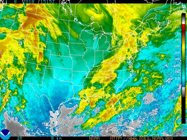
That is part of a trough and an upper low in Mexico so nothing tropical from that but when you see a blob like that in that area you have to watch it just in case but right now no development.
Bay of campeche blob
Moderator: S2k Moderators
Forum rules

The posts in this forum are NOT official forecasts and should not be used as such. They are just the opinion of the poster and may or may not be backed by sound meteorological data. They are NOT endorsed by any professional institution or STORM2K. For official information, please refer to products from the National Hurricane Center and National Weather Service.
-
cycloneye

- Admin

- Posts: 149721
- Age: 69
- Joined: Thu Oct 10, 2002 10:54 am
- Location: San Juan, Puerto Rico
Bay of campeche blob
0 likes
Visit the Caribbean-Central America Weather Thread where you can find at first post web cams,radars
and observations from Caribbean basin members Click Here
and observations from Caribbean basin members Click Here
-
Guest


-
Guest
-
Guest
-
Guest
-
wx247

- S2K Supporter

- Posts: 14279
- Age: 42
- Joined: Wed Feb 05, 2003 10:35 pm
- Location: Monett, Missouri
- Contact:
Something to watch I guess... looks nice on the satellite, but nothing imminent here!
0 likes
Personal Forecast Disclaimer:
The posts in this forum are NOT official forecast and should not be used as such. They are just the opinion of the poster and may or may not be backed by sound meteorological data. They are NOT endorsed by any professional institution or storm2k.org. For official information, please refer to the NHC and NWS products.
The posts in this forum are NOT official forecast and should not be used as such. They are just the opinion of the poster and may or may not be backed by sound meteorological data. They are NOT endorsed by any professional institution or storm2k.org. For official information, please refer to the NHC and NWS products.
-
Guest
-
PTrackerLA

- Category 5

- Posts: 5281
- Age: 42
- Joined: Thu Oct 10, 2002 8:40 pm
- Location: Lafayette, LA
-
weatherlover427
MIDDLE/UPPER LEVEL SYNOPTIC FEATURES...
GULF OF MEXICO...MIDDLE TO UPPER LEVEL CYCLONIC CIRCULATION CENTER IN NORTHERN MEXICO ABOUT 250 NM SE OF EL PASO TEXAS. A COASTAL SURFACE TROUGH HAS DEVELOPED ALONG 96W FROM 20N TO 28N IN WESTERN GULF OF MEXICO. NUMEROUS STRONG CONVECTIVE ACTIVITY IN SW CORNER...DISSIPATING A BIT DURING THE PAST FOUR HOURS...WITH A NEW BURST DEVELOPING JUST SE WITHIN 30 NM RADIUS 21N94W. UPPER LEVEL SW TO WESTERLY WIND FLOW IN REST OF GULF OF MEXICO.
GULF OF MEXICO...MIDDLE TO UPPER LEVEL CYCLONIC CIRCULATION CENTER IN NORTHERN MEXICO ABOUT 250 NM SE OF EL PASO TEXAS. A COASTAL SURFACE TROUGH HAS DEVELOPED ALONG 96W FROM 20N TO 28N IN WESTERN GULF OF MEXICO. NUMEROUS STRONG CONVECTIVE ACTIVITY IN SW CORNER...DISSIPATING A BIT DURING THE PAST FOUR HOURS...WITH A NEW BURST DEVELOPING JUST SE WITHIN 30 NM RADIUS 21N94W. UPPER LEVEL SW TO WESTERLY WIND FLOW IN REST OF GULF OF MEXICO.
0 likes

-
PTrackerLA
- Category 5
- Posts: 5281
- Age: 42
- Joined: Thu Oct 10, 2002 8:40 pm
- Location: Lafayette, LA
-
Guest
-
southerngale

- Retired Staff

- Posts: 27418
- Joined: Thu Oct 10, 2002 1:27 am
- Location: Southeast Texas (Beaumont area)

 my Cowboys
 -
Guest
-
southerngale
- Retired Staff
- Posts: 27418
- Joined: Thu Oct 10, 2002 1:27 am
- Location: Southeast Texas (Beaumont area)
Who is online
Users browsing this forum: No registered users and 138 guests