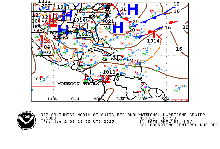
Invest 97L Models... (deceleration going on)

This is the general tropical discussion area. Anyone can take their shot at predicting a storms path.

Moderator: S2k Moderators

Forum rules

The posts in this forum are NOT official forecasts and should not be used as such. They are just the opinion of the poster and may or may not be backed by sound meteorological data. They are NOT endorsed by any professional institution or STORM2K. For official information, please refer to products from the National Hurricane Center and National Weather Service.

Help Support Storm2K
Message
Author
User avatar
senorpepr
Military Met/Moderator
Posts: 12542
Age: 43
Joined: Fri Aug 22, 2003 9:22 pm
Location: Mackenbach, Germany
Contact:

Invest 97L Models... (deceleration going on)

#1 Postby senorpepr » Thu Jul 22, 2004 2:06 am

Invest 97L
22/06Z
15.8N 73.3W
W @ 13 mph
30 mph
1011 mb / 29.85"

Code: Select all

684
WHXX01 KWBC 220657
CHGHUR

 DISCLAIMER...NUMERICAL MODELS ARE SUBJECT TO LARGE ERRORS.
 PLEASE REFER TO TPC/NHC OFFICIAL FORECASTS FOR TROPICAL CYCLONES.

    .....THE FOLLOWING IS A TEST MESSAGE.....

  NATIONAL HURRICANE CENTER NORTH ATLANTIC OBJECTIVE AIDS FOR

  TROPICAL DEPRESSION INVEST     (AL972004) ON 20040722  0600 UTC

          ...00 HRS...   ...12 HRS...   ...24 HRS...   ...36 HRS...
          040722  0600   040722  1800   040723  0600   040723  1800

           LAT    LON     LAT    LON     LAT    LON     LAT    LON
  BAMD    15.8N  73.3W   15.9N  75.7W   16.2N  78.2W   16.7N  80.6W
  BAMM    15.8N  73.3W   16.3N  75.7W   16.7N  78.0W   17.3N  80.3W
  A98E    15.8N  73.3W   16.1N  75.5W   16.4N  77.6W   16.7N  79.6W
  LBAR    15.8N  73.3W   16.0N  75.3W   16.5N  77.7W   17.4N  80.2W
  SHIP        25KTS          28KTS          33KTS          39KTS
  DSHP        25KTS          28KTS          33KTS          39KTS

          ...48 HRS...   ...72 HRS...   ...96 HRS...   ..120 HRS...
          040724  0600   040725  0600   040726  0600   040727  0600

           LAT    LON     LAT    LON     LAT    LON     LAT    LON
  BAMD    17.1N  82.9W   17.7N  87.5W   18.0N  92.0W   18.1N  95.6W
  BAMM    18.0N  82.5W   19.2N  86.5W   20.0N  90.3W   20.7N  92.8W
  A98E    17.4N  81.4W   18.5N  85.3W   19.8N  88.7W   21.3N  91.2W
  LBAR    18.5N  82.7W   21.2N  87.1W   23.9N  90.9W   26.1N  91.8W
  SHIP        45KTS          58KTS          68KTS          75KTS
  DSHP        45KTS          58KTS          31KTS          41KTS

               ...INITIAL CONDITIONS...
  LATCUR =  15.8N LONCUR =  73.3W DIRCUR = 280DEG SPDCUR =  11KT
  LATM12 =  15.4N LONM12 =  71.3W DIRM12 = 282DEG SPDM12 =  10KT
  LATM24 =  15.0N LONM24 =  69.0W
  WNDCUR =   25KT RMAXWD =   60NM WNDM12 =   25KT
  CENPRS = 1011MB OUTPRS = 1013MB OUTRAD =  120NM SDEPTH =   M
  RD34NE =    0NM RD34SE =    0NM RD34SW =    0NM RD34NW =   0NM

  .....THE ABOVE HAS BEEN A TEST MESSAGE.....
0 likes   

User avatar
wxman57
Moderator-Pro Met
Moderator-Pro Met
Posts: 23080
Age: 68
Joined: Sat Jun 21, 2003 8:06 pm
Location: Houston, TX (southwest)

#2 Postby wxman57 » Thu Jul 22, 2004 4:50 am

Not really, the wave axis can be seen at 77W as of 4:30am CDT. It's not back at 73-74W.
0 likes   

User avatar
senorpepr
Military Met/Moderator
Posts: 12542
Age: 43
Joined: Fri Aug 22, 2003 9:22 pm
Location: Mackenbach, Germany
Contact:

#3 Postby senorpepr » Thu Jul 22, 2004 5:16 am

Granted the wave axis is around 77W...

Image

...however it appears that the models were set for the area of convection that's still south of Haiti, which is approaching 73.5-74W

Image

It appears as the wave is continuing at 20-25mph while the convection, or the remnants, are slowing down.
0 likes   


Return to “Talkin' Tropics”

Who is online

Users browsing this forum: No registered users and 84 guests