Latest forecast for ENSO shows warming but not strong

This is the general tropical discussion area. Anyone can take their shot at predicting a storms path.

Moderator: S2k Moderators

Forum rules

The posts in this forum are NOT official forecasts and should not be used as such. They are just the opinion of the poster and may or may not be backed by sound meteorological data. They are NOT endorsed by any professional institution or STORM2K. For official information, please refer to products from the National Hurricane Center and National Weather Service.

Help Support Storm2K
Message
Author
User avatar
cycloneye
Admin
Admin
Posts: 146136
Age: 69
Joined: Thu Oct 10, 2002 10:54 am
Location: San Juan, Puerto Rico

Latest forecast for ENSO shows warming but not strong

#1 Postby cycloneye » Tue Dec 16, 2003 7:31 am

http://www.emc.ncep.noaa.gov/research/c ... cordxy.gif

Yes the yellows and oranges are there indicating warm ENSO but it does not show a strong el nino at el nino 3 area.A strong el nino would show a big blob of orange and red colors at el nino regions 1-2 and el nino 3.

Here is the viewing of the pacific this week and shows not a big warming pacific. :darrow: :darrow: :darrow: :darrow:
http://www.pmel.noaa.gov/tao/jsdisplay/ ... y_ps32.gif
0 likes   
Visit the Caribbean-Central America Weather Thread where you can find at first post web cams,radars
and observations from Caribbean basin members Click Here

User avatar
dixiebreeze
S2K Supporter
S2K Supporter
Posts: 5140
Joined: Wed Sep 03, 2003 5:07 pm
Location: crystal river, fla.

#2 Postby dixiebreeze » Tue Dec 16, 2003 8:45 am

Thank you Luis. Interesting. Is that the way the forecast looked for this year do you recall?
0 likes   

User avatar
cycloneye
Admin
Admin
Posts: 146136
Age: 69
Joined: Thu Oct 10, 2002 10:54 am
Location: San Juan, Puerto Rico

#3 Postby cycloneye » Tue Dec 16, 2003 8:50 am

By this time last year it was a little bit cooler those waters but there is not a big diference from last year at this date to now.
0 likes   
Visit the Caribbean-Central America Weather Thread where you can find at first post web cams,radars
and observations from Caribbean basin members Click Here

User avatar
dixiebreeze
S2K Supporter
S2K Supporter
Posts: 5140
Joined: Wed Sep 03, 2003 5:07 pm
Location: crystal river, fla.

#4 Postby dixiebreeze » Tue Dec 16, 2003 12:49 pm

So I guess that means we might still expect a busy 2004 season even if it isn't terribly warm.
0 likes   

User avatar
Typhoon_Willie
Category 5
Category 5
Posts: 1042
Joined: Mon Jun 09, 2003 3:19 pm
Location: Greenacres City, Florida

#5 Postby Typhoon_Willie » Tue Dec 16, 2003 1:21 pm

That is correct Dixiebreeze! It should be busy!
0 likes   

User avatar
RNS
Professional-Met
Professional-Met
Posts: 522
Joined: Tue Nov 04, 2003 6:29 pm
Location: Saylorsburg PA
Contact:

#6 Postby RNS » Thu Dec 18, 2003 3:53 pm

I agree luis...however the model may be overdoing the amount of warming off the south american coast.

Image

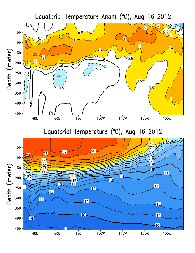
unless sub-surface temperature anomalies begin to increase rapidly in the nino 3.0 and 1+2 regions over the next few months...i dont forsee such dramatic warming taking place that far west. also...the long term PDO cold phase would argue against it as well.

another thing to consider is where the warmest SSTA relative to normal have been (and continue to be at this time) which of course is in the NINO 3.4 and 4.0 regions. This is usually where the warmest SSTA core takes shape during El Nino years in the long term PDO cold phase (or at least is more "normal" for those periods).

I DO think that evolution toward weak El Nino conditions will continue (we are for the most part just about there)...and a weak EL Nino should be present for at least the beginning of the tropcal season.

Image

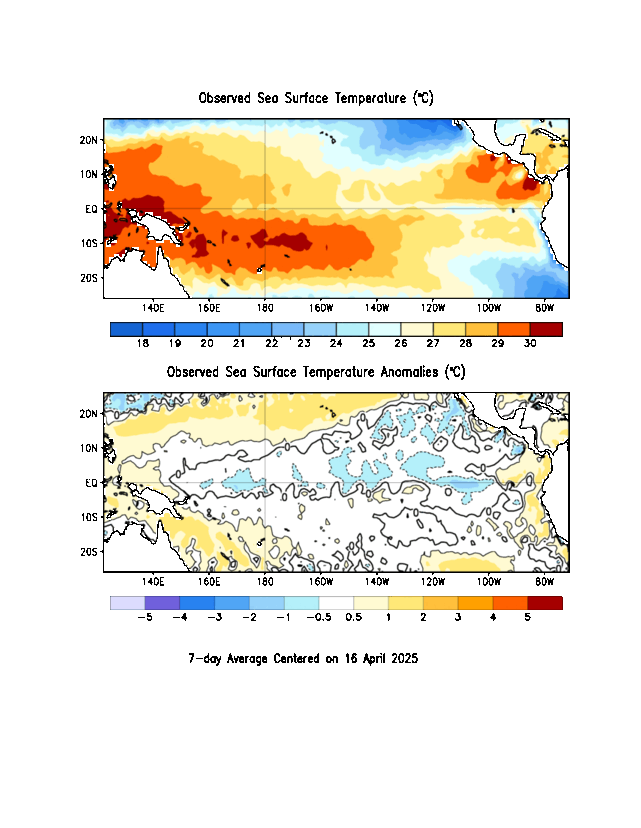
The Nino 3.4 and 4.0 regions have laso displayed the most consistency with regard to the resilliance of the warming in the region...whereas further to the east...the warming has taken place in pulses.
0 likes   

User avatar
cycloneye
Admin
Admin
Posts: 146136
Age: 69
Joined: Thu Oct 10, 2002 10:54 am
Location: San Juan, Puerto Rico

#7 Postby cycloneye » Thu Dec 18, 2003 4:01 pm

RNS another thing to consider is the SOI that is positive now and that may be important too to know what kind of ENSO will be in the next few months.
0 likes   
Visit the Caribbean-Central America Weather Thread where you can find at first post web cams,radars
and observations from Caribbean basin members Click Here

User avatar
RNS
Professional-Met
Professional-Met
Posts: 522
Joined: Tue Nov 04, 2003 6:29 pm
Location: Saylorsburg PA
Contact:

#8 Postby RNS » Thu Dec 18, 2003 4:10 pm

cycloneye wrote:RNS another thing to consider is the SOI that is positive now and that may be important too to know what kind of ENSO will be in the next few months.


The SOI has been up and down over the past few months (though averaging slightly negative)...IOW too inconsistent to imply the developmnet of a moderate or strong warm episode. IF we were to be trending towards such an event...the SOI would respond by going strongly negative...and MJO activity would decrease greatly.

Just the same as one would want to see an increasingly positive SOI if looking for the development of a weak or moderate la nina event.

over the past few months the SOI has been averaging between 0.0 and -1.0 which would indicate borderline weak El nino conditions...as we are currently dealing with.

http://www.cdc.noaa.gov/correlation/soi.data
0 likes   

User avatar
cycloneye
Admin
Admin
Posts: 146136
Age: 69
Joined: Thu Oct 10, 2002 10:54 am
Location: San Juan, Puerto Rico

#9 Postby cycloneye » Thu Dec 18, 2003 4:28 pm

RNS wrote:
cycloneye wrote:RNS another thing to consider is the SOI that is positive now and that may be important too to know what kind of ENSO will be in the next few months.


The SOI has been up and down over the past few months (though averaging slightly negative)...IOW too inconsistent to imply the developmnet of a moderate or strong warm episode. IF we were to be trending towards such an event...the SOI would respond by going strongly negative...and MJO activity would decrease greatly.

Just the same as one would want to see an increasingly positive SOI if looking for the development of a weak or moderate la nina event.

over the past few months the SOI has been averaging between 0.0 and -1.0 which would indicate borderline weak El nino conditions...as we are currently dealing with.

http://www.cdc.noaa.gov/correlation/soi.data


RNS my view of ENSO in terms of the 2004 hurricane season is that it wont have a big effect being even a warm ENSO or weak el nino because there will be other important factors that will enhance atlantic tropical development and to mention a couple of them the QBO winds will be from the west which are favorable for developments and of course the ATC (ATLANTIC THERMOLINE CIRCULATION).
0 likes   
Visit the Caribbean-Central America Weather Thread where you can find at first post web cams,radars
and observations from Caribbean basin members Click Here

User avatar
RNS
Professional-Met
Professional-Met
Posts: 522
Joined: Tue Nov 04, 2003 6:29 pm
Location: Saylorsburg PA
Contact:

#10 Postby RNS » Thu Dec 18, 2003 4:43 pm

cycloneye wrote:
RNS wrote:
cycloneye wrote:RNS another thing to consider is the SOI that is positive now and that may be important too to know what kind of ENSO will be in the next few months.


The SOI has been up and down over the past few months (though averaging slightly negative)...IOW too inconsistent to imply the developmnet of a moderate or strong warm episode. IF we were to be trending towards such an event...the SOI would respond by going strongly negative...and MJO activity would decrease greatly.

Just the same as one would want to see an increasingly positive SOI if looking for the development of a weak or moderate la nina event.

over the past few months the SOI has been averaging between 0.0 and -1.0 which would indicate borderline weak El nino conditions...as we are currently dealing with.

http://www.cdc.noaa.gov/correlation/soi.data


RNS my view of ENSO in terms of the 2004 hurricane season is that it wont have a big effect being even a warm ENSO or weak el nino because there will be other important factors that will enhance atlantic tropical development and to mention a couple of them the QBO winds will be from the west which are favorable for developments and of course the ATC (ATLANTIC THERMOLINE CIRCULATION).


I dont think we can expect to see the level of activity which we did this year...however normal to slightly above normal TC activity (and strike potential) is likely in the atlantic...and yes i strongly agree with you in regard to the effect (or lack thereof) that any weak warm or borderline weak warm ENSO event will have on the ability to limit development in the atlantic basin this coming season based on various other factors.
0 likes   

User avatar
cycloneye
Admin
Admin
Posts: 146136
Age: 69
Joined: Thu Oct 10, 2002 10:54 am
Location: San Juan, Puerto Rico

#11 Postby cycloneye » Thu Dec 18, 2003 4:55 pm

RNS I am in the camp of slightly above average 2004 season 12/6/2 but that could change up or down in the next few as all the factors come into play.

But I wonder why Dr Gray went with above average season 13/7/3 however on april he will come out again so let's see if he stays the same go down or go up in his forecast numbers.
0 likes   
Visit the Caribbean-Central America Weather Thread where you can find at first post web cams,radars
and observations from Caribbean basin members Click Here

User avatar
RNS
Professional-Met
Professional-Met
Posts: 522
Joined: Tue Nov 04, 2003 6:29 pm
Location: Saylorsburg PA
Contact:

#12 Postby RNS » Thu Dec 18, 2003 5:00 pm

cycloneye wrote:RNS I am in the camp of slightly above average 2004 season 12/6/2 but that could change up or down in the next few as all the factors come into play.

But I wonder why Dr Gray went with above average season 13/7/3 however on april he will come out again so let's see if he stays the same go down or go up in his forecast numbers.


and as you can tell i/m also with you on that...If i had to make a bet i would say that he either stickes with his previous forecast...or increases those numbers somewhat...especially once the trend in the ENSO becomes more clear.
0 likes   

User avatar
RNS
Professional-Met
Professional-Met
Posts: 522
Joined: Tue Nov 04, 2003 6:29 pm
Location: Saylorsburg PA
Contact:

#13 Postby RNS » Thu Dec 18, 2003 5:03 pm

the QBO is east --- increasing west and will turn west well before the start of the tropical season...strong ATC...and warm atlantic basin...so the set up is there for another above normal season.
0 likes   

User avatar
cycloneye
Admin
Admin
Posts: 146136
Age: 69
Joined: Thu Oct 10, 2002 10:54 am
Location: San Juan, Puerto Rico

#14 Postby cycloneye » Thu Dec 18, 2003 5:16 pm

Now the only thing for you,me and all who make forecasts is to wait for the factors to evolve themselves in what direction they will be in the next few months and then we will have a more clear picture of what kind of 2004 season it will be.
0 likes   
Visit the Caribbean-Central America Weather Thread where you can find at first post web cams,radars
and observations from Caribbean basin members Click Here

User avatar
RNS
Professional-Met
Professional-Met
Posts: 522
Joined: Tue Nov 04, 2003 6:29 pm
Location: Saylorsburg PA
Contact:

#15 Postby RNS » Thu Dec 18, 2003 10:17 pm

cycloneye wrote:Now the only thing for you,me and all who make forecasts is to wait for the factors to evolve themselves in what direction they will be in the next few months and then we will have a more clear picture of what kind of 2004 season it will be.


and it should also be noted that the eastern pacific tropical season should see slightly below normal TC development...consistent with the aforementioned factors and the implications of those factorsa on the E PAC season.
0 likes   

User avatar
cycloneye
Admin
Admin
Posts: 146136
Age: 69
Joined: Thu Oct 10, 2002 10:54 am
Location: San Juan, Puerto Rico

#16 Postby cycloneye » Fri Dec 19, 2003 6:32 am

RNS wrote:
cycloneye wrote:Now the only thing for you,me and all who make forecasts is to wait for the factors to evolve themselves in what direction they will be in the next few months and then we will have a more clear picture of what kind of 2004 season it will be.


and it should also be noted that the eastern pacific tropical season should see slightly below normal TC development...consistent with the aforementioned factors and the implications of those factorsa on the E PAC season.


RNS if the EPAC goes slightly below average then the atlantic has an active season that is what normally happens but some years both have similar seasons as the data historicly shows. By the way in 2003 the EPAC didn't see one single major cane.
0 likes   
Visit the Caribbean-Central America Weather Thread where you can find at first post web cams,radars
and observations from Caribbean basin members Click Here


Return to “Talkin' Tropics”

Who is online

Users browsing this forum: abajan, CDO, chris_fit, Google [Bot], Google Adsense [Bot], HeatherAKC, jlauderdal, LAF92, Orlando_wx, riapal, SFLcane, Shawee, Stratton23, TampaWxLurker, texsn95, TheBurn, Tree, Weathertracker96, wzrgirl1 and 181 guests