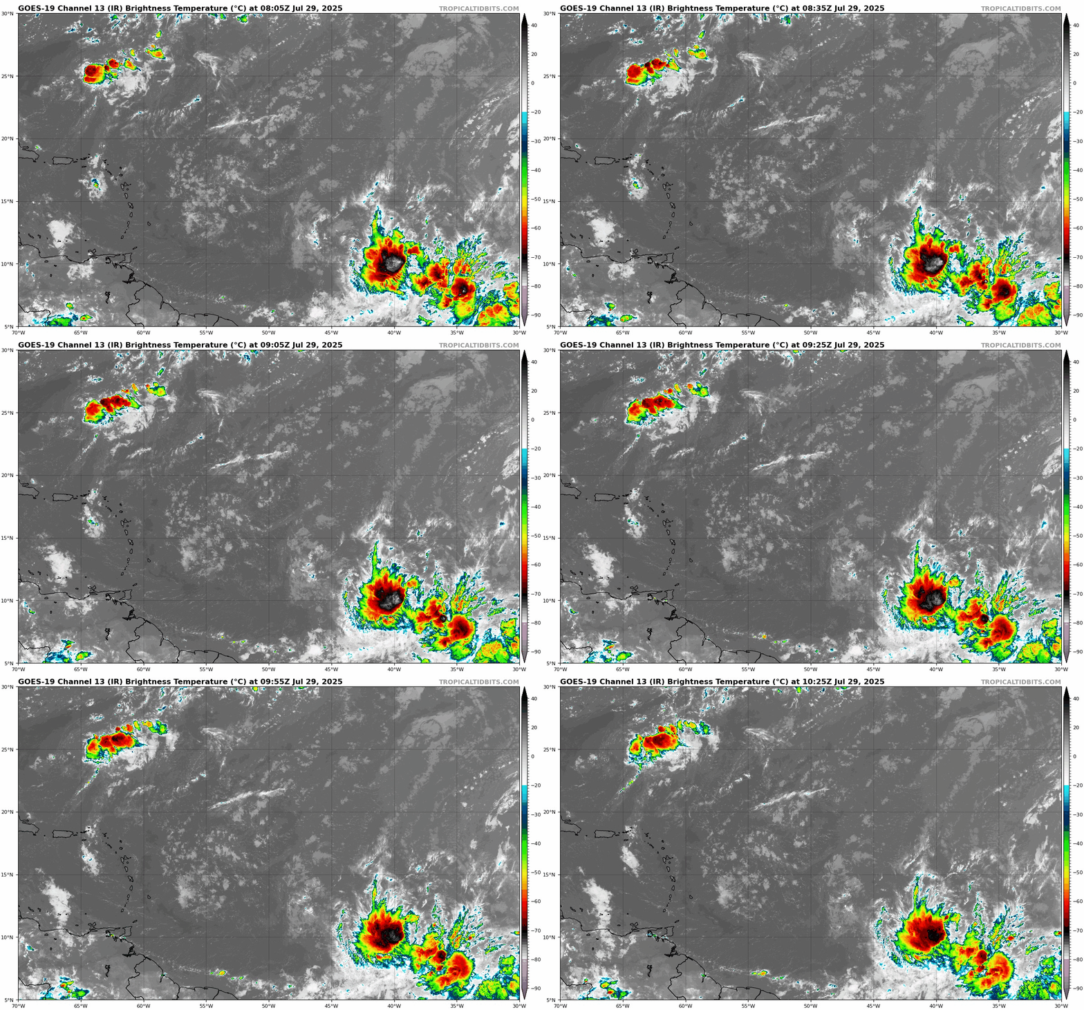
Central Atlantic Tropical Wave

This is the general tropical discussion area. Anyone can take their shot at predicting a storms path.

Moderator: S2k Moderators

Forum rules

The posts in this forum are NOT official forecasts and should not be used as such. They are just the opinion of the poster and may or may not be backed by sound meteorological data. They are NOT endorsed by any professional institution or STORM2K. For official information, please refer to products from the National Hurricane Center and National Weather Service.

Help Support Storm2K
Message
Author
User avatar
Blown Away
S2K Supporter
S2K Supporter
Posts: 10166
Joined: Wed May 26, 2004 6:17 am

Central Atlantic Tropical Wave

#1 Postby Blown Away » Tue Jul 29, 2025 5:45 am

Image
I'm a little surprised this area has not been tagged with a 10% Lemon... Persistent convection and some model support in the long range...
0 likes   
Hurricane Eye Experience: David 79, Irene 99, Frances 04, Jeanne 04, Wilma 05… Hurricane Brush Experience: Andrew 92, Erin 95, Floyd 99, Matthew 16, Irma 17, Ian 22, Nicole 22…

User avatar
tropicwatch
Category 5
Category 5
Posts: 3403
Age: 61
Joined: Sat Jun 02, 2007 10:01 am
Location: Panama City Florida
Contact:

Re: Central Atlantic Tropical Wave

#2 Postby tropicwatch » Tue Jul 29, 2025 6:09 am

Have been looking at that wave this morning. The 925mb vorticity is fairly impressive.

https://tropic.ssec.wisc.edu/real-time/windmain.php?&basin=atlantic&sat=wg8&prod=vor5&zoom=&time=
2 likes   
Tropicwatch


Agnes 72', Eloise 75, Elena 85', Kate 85', Charley 86', Florence 88', Beryl 94', Dean 95', Erin 95', Opal 95', Earl 98', Georges 98', Ivan 2004', Arlene 2005', Dennis 2005', Ida 2009' Debby 2012' Irma 2017' Michael 2018'

User avatar
stormchazer
Category 5
Category 5
Posts: 2462
Joined: Fri Aug 29, 2003 12:00 pm
Location: Lakeland, Florida
Contact:

Re: Central Atlantic Tropical Wave

#3 Postby stormchazer » Tue Jul 29, 2025 7:59 am

Blown Away wrote:[url]https://i.postimg.cc/fRD57cDX/07f31414-e031-45d3-90b0-8692ecc8cda2.gif [/url]
I'm a little surprised this area has not been tagged with a 10% Lemon... Persistent convection and some model support in the long range...


There is a swath of Saharan Dust out ahead of it. In light of its location in the open Atlantic, maybe they’re taking a wait and see approach.
1 likes   
The posts or stuff said are NOT an official forecast and my opinion alone. Please look to the NHC and NWS for official forecasts and products.

Model Runs Cheat Sheet:
GFS (5:30 AM/PM, 11:30 AM/PM)
HWRF, GFDL, UKMET, NAVGEM (6:30-8:00 AM/PM, 12:30-2:00 AM/PM)
ECMWF (1:45 AM/PM)
TCVN is a weighted averaged

Opinions my own.

User avatar
ScottNAtlanta
Category 5
Category 5
Posts: 2428
Joined: Sat May 25, 2013 3:11 pm
Location: Atlanta, GA

Re: Central Atlantic Tropical Wave

#4 Postby ScottNAtlanta » Tue Jul 29, 2025 12:49 pm

tropicwatch wrote:Have been looking at that wave this morning. The 925mb vorticity is fairly impressive.

https://tropic.ssec.wisc.edu/real-time/windmain.php?&basin=atlantic&sat=wg8&prod=vor5&zoom=&time=

Not only at 925mb but all the way up to 500mb stacked. The one behind it just south of the islands looks like it has some rotation too.
1 likes   
The posts in this forum are NOT official forecast and should not be used as such. They are just the opinion of the poster and may or may not be backed by sound meteorological data. They are NOT endorsed by any professional institution or storm2k.org. For official information, please refer to the NHC and NWS products.

User avatar
Nimbus
Category 5
Category 5
Posts: 5357
Joined: Mon Jul 19, 2004 10:54 am

Re: Central Atlantic Tropical Wave

#5 Postby Nimbus » Tue Jul 29, 2025 2:10 pm

Blown Away wrote:[url]https://i.postimg.cc/fRD57cDX/07f31414-e031-45d3-90b0-8692ecc8cda2.gif [/url]
I'm a little surprised this area has not been tagged with a 10% Lemon... Persistent convection and some model support in the long range...


Its already starting to dry out at 10N and the environment to the WNW is still brutally dry.
No circulation evident yet but, these early waves pull moisture up from the ITCZ that reduce the SAL for following systems closer to Cape Verde season.

Image
1 likes   


Return to “Talkin' Tropics”

Who is online

Users browsing this forum: cheezyWXguy, Google Adsense [Bot], MetroMike, NDG, ScottNAtlanta, TallyTracker, TampaWxLurker, tolakram and 79 guests