
Since there's a weak surface trough and an area of disturbed weather (albeit a decaying MCS) in this area, plus the model guidance is showing some sort of surface low development over the next few days, I think it's sufficient to start a new thread for potential development.
Post away...
Possible Development Near the Central Gulf Coast
Moderator: S2k Moderators
Forum rules

The posts in this forum are NOT official forecasts and should not be used as such. They are just the opinion of the poster and may or may not be backed by sound meteorological data. They are NOT endorsed by any professional institution or STORM2K. For official information, please refer to products from the National Hurricane Center and National Weather Service.
-
cycloneye

- Admin

- Posts: 149727
- Age: 69
- Joined: Thu Oct 10, 2002 10:54 am
- Location: San Juan, Puerto Rico
Re: Possible Development Near the Central Gulf Coast

3 likes
Visit the Caribbean-Central America Weather Thread where you can find at first post web cams,radars
and observations from Caribbean basin members Click Here
and observations from Caribbean basin members Click Here
-
Ivanhater

- Storm2k Moderator

- Posts: 11222
- Age: 39
- Joined: Fri Jul 01, 2005 8:25 am
- Location: Pensacola
Re: Possible Development Near the Central Gulf Coast
Model update ..


Sent from my LM-G900TM using Tapatalk
Sent from my LM-G900TM using Tapatalk
6 likes
Michael
-
cycloneye
- Admin
- Posts: 149727
- Age: 69
- Joined: Thu Oct 10, 2002 10:54 am
- Location: San Juan, Puerto Rico
Re: Possible Development Near the Central Gulf Coast
Tropical Weather Outlook
NWS National Hurricane Center Miami FL
800 AM EDT Sun Jul 10 2022
For the North Atlantic...Caribbean Sea and the Gulf of Mexico:
Northern Gulf of Mexico:
A surface trough of low pressure is expected to develop in the
northern Gulf of Mexico from a decaying frontal boundary currently
located over the southeastern United States. Any development of
this system is expected to be slow to occur while it drifts just
offshore of the northern Gulf of Mexico coastline through the middle
to later part of this week. Regardless of development, heavy rains
will be possible along portions of the northern Gulf coastline from
Louisiana to the Florida Panhandle over the next several days. For
more information about the potential for heavy rain, please see
products issued by your local National Weather Service Office.
* Formation chance through 48 hours...low...near 0 percent.
* Formation change through 5 days...low...20 percent.
$$
Forecaster Papin

2 likes
Visit the Caribbean-Central America Weather Thread where you can find at first post web cams,radars
and observations from Caribbean basin members Click Here
and observations from Caribbean basin members Click Here

Re: Possible Development Near the Central Gulf Coast
Local guys talking early about it lol
https://twitter.com/travisabc13/status/ ... sz2Ox-OHSQ
https://twitter.com/travisabc13/status/ ... sz2Ox-OHSQ
0 likes
Harvey,Hanna,Beta,Texas Winter storm2021,Nicholas,Beryl
-
wxman57

- Moderator-Pro Met

- Posts: 23175
- Age: 68
- Joined: Sat Jun 21, 2003 8:06 pm
- Location: Houston, TX (southwest)
Re: Possible Development Near the Central Gulf Coast
Main "threat" will be the benefit of more rainfall. I'm pulling for the ECMWF, which puts the weak low inland into SE TX.
7 likes
Re: Possible Development Near the Central Gulf Coast
wxman57 wrote:Main "threat" will be the benefit of more rainfall. I'm pulling for the ECMWF, which puts the weak low inland into SE TX.
Let’s go Euro!
1 likes
Harvey,Hanna,Beta,Texas Winter storm2021,Nicholas,Beryl
-
ElectricStorm

- Category 5

- Posts: 5156
- Age: 25
- Joined: Tue Aug 13, 2019 11:23 pm
- Location: Norman, OK
Re: Possible Development Near the Central Gulf Coast
This reminds me a bit of Barry 2019 though this shouldn't have much of a chance to become a hurricane. Could bring some nice rain to TX though.
1 likes
B.S Meteorology, University of Oklahoma '25
Please refer to the NHC, NWS, or SPC for official information.
Please refer to the NHC, NWS, or SPC for official information.

-
PTrackerLA

- Category 5
- Posts: 5281
- Age: 42
- Joined: Thu Oct 10, 2002 8:40 pm
- Location: Lafayette, LA
Re: Possible Development Near the Central Gulf Coast
We need the rain here in Lafayette, 12" deficit for the year but more like 18"+ going back to October 2021. The heat indexes have been brutal I would love a rainy week lol.
0 likes
-
Janie2006

- Category 5
- Posts: 1329
- Joined: Mon Sep 18, 2006 3:28 pm
- Location: coastal Ms aka home of the hurricanes
Re: Possible Development Near the Central Gulf Coast
I’m never going to complain about rain during summer in coastal Alabama. Well, most of the time.
That MCS moved through last night/early this morning and it seems to be maintaining itself, at the least. It’ll be interesting to see what happens. I’ve seen an MCS over the open waters do nothing and I’ve seen them become tropical systems.
That MCS moved through last night/early this morning and it seems to be maintaining itself, at the least. It’ll be interesting to see what happens. I’ve seen an MCS over the open waters do nothing and I’ve seen them become tropical systems.
1 likes

Re: Possible Development Near the Central Gulf Coast
Digging southwest of NOLA so it will be invest worthy soon.
The longer the trough digs the more likely Euro will verify.
Back side of the trough will keep it out over the gulf drifting west till the next short wave?
The longer the trough digs the more likely Euro will verify.
Back side of the trough will keep it out over the gulf drifting west till the next short wave?
1 likes

Re: Possible Development Near the Central Gulf Coast
I'm all in for some rain, but after 2 months of only a half inch, I don't want heavy downpours. I agree with the poster above that I'll never complain about summer rain again. Bought a new riding mower in May and only used it twice.
0 likes
Alicia, Rita, Ike, Harvey and Beryl...moved to Splendora lol
-
vbhoutex

- Storm2k Executive
- Posts: 29150
- Age: 74
- Joined: Wed Oct 09, 2002 11:31 pm
- Location: Cypress, TX
- Contact:
Re: Possible Development Near the Central Gulf Coast
wxman57 wrote:Main "threat" will be the benefit of more rainfall. I'm pulling for the ECMWF, which puts the weak low inland into SE TX.
Alright, who kidnapped Wxman57? This could make it too cool for him to ride. Past that I am also rooting for ECMWF!!
5 likes
Skywarn, C.E.R.T.
Please click below to donate to STORM2K to help with the expenses of keeping the site going:

Please click below to donate to STORM2K to help with the expenses of keeping the site going:
-
Iceresistance

- Category 5
- Posts: 9608
- Age: 22
- Joined: Sat Oct 10, 2020 9:45 am
- Location: Tecumseh, OK/Norman, OK
Re: Possible Development Near the Central Gulf Coast
vbhoutex wrote:wxman57 wrote:Main "threat" will be the benefit of more rainfall. I'm pulling for the ECMWF, which puts the weak low inland into SE TX.
Alright, who kidnapped Wxman57? This could make it too cool for him to ride. Past that I am also rooting for ECMWF!!
Maybe he wants the rain to create more heat and humidity.
1 likes
Bill 2015 & Beta 2020
Winter 2020-2021
All observations are in Tecumseh, OK unless otherwise noted.
Winter posts are focused mainly for Oklahoma & Texas.
Take any of my forecasts with a grain of salt, refer to the NWS, SPC, and NHC for official information
Never say Never with weather! Because ANYTHING is possible!
Winter 2020-2021
All observations are in Tecumseh, OK unless otherwise noted.
Winter posts are focused mainly for Oklahoma & Texas.
Take any of my forecasts with a grain of salt, refer to the NWS, SPC, and NHC for official information
Never say Never with weather! Because ANYTHING is possible!
-
cycloneye
- Admin
- Posts: 149727
- Age: 69
- Joined: Thu Oct 10, 2002 10:54 am
- Location: San Juan, Puerto Rico
Re: Possible Development Near the Central Gulf Coast
Tropical Weather Outlook
NWS National Hurricane Center Miami FL
200 PM EDT Sun Jul 10 2022
For the North Atlantic...Caribbean Sea and the Gulf of Mexico:
1. Northern Gulf of Mexico:
A surface trough of low pressure is expected to form in the northern
Gulf of Mexico, partially related to a decaying frontal boundary
currently located over the southeastern United States. Any
development of this system is expected to be slow to occur while it
drifts just offshore of the northern Gulf of Mexico coastline
through the middle to later part of this week. Regardless of
development, heavy rains will be possible along portions of the
northern Gulf coastline from Louisiana to the Florida Panhandle over
the next several days. For more information about the potential for
heavy rain, please see products issued by your local National
Weather Service office and the Weather Prediction Center.
* Formation chance through 48 hours...low...near 0 percent.
* Formation change through 5 days...low...20 percent.
Forecaster Papin
0 likes
Visit the Caribbean-Central America Weather Thread where you can find at first post web cams,radars
and observations from Caribbean basin members Click Here
and observations from Caribbean basin members Click Here
-
skyline385

- Category 5
- Posts: 2728
- Age: 35
- Joined: Wed Aug 26, 2020 11:15 pm
- Location: Houston TX
Re: Possible Development Near the Central Gulf Coast
Gulf SSTs are also ridiculously high right now because of the death ridge. If conditions support it, it has potential to spin up very quickly.

0 likes
Re: Possible Development Near the Central Gulf Coast
This is a live link where its currently easy to spot the upper air circulation, large high to the north and upper level low centered near Cuba.
https://www.tropicaltidbits.com/sat/sat ... uct=wv_mid
https://www.tropicaltidbits.com/sat/sat ... uct=wv_mid
0 likes
-
PTrackerLA
- Category 5
- Posts: 5281
- Age: 42
- Joined: Thu Oct 10, 2002 8:40 pm
- Location: Lafayette, LA
Re: Possible Development Near the Central Gulf Coast
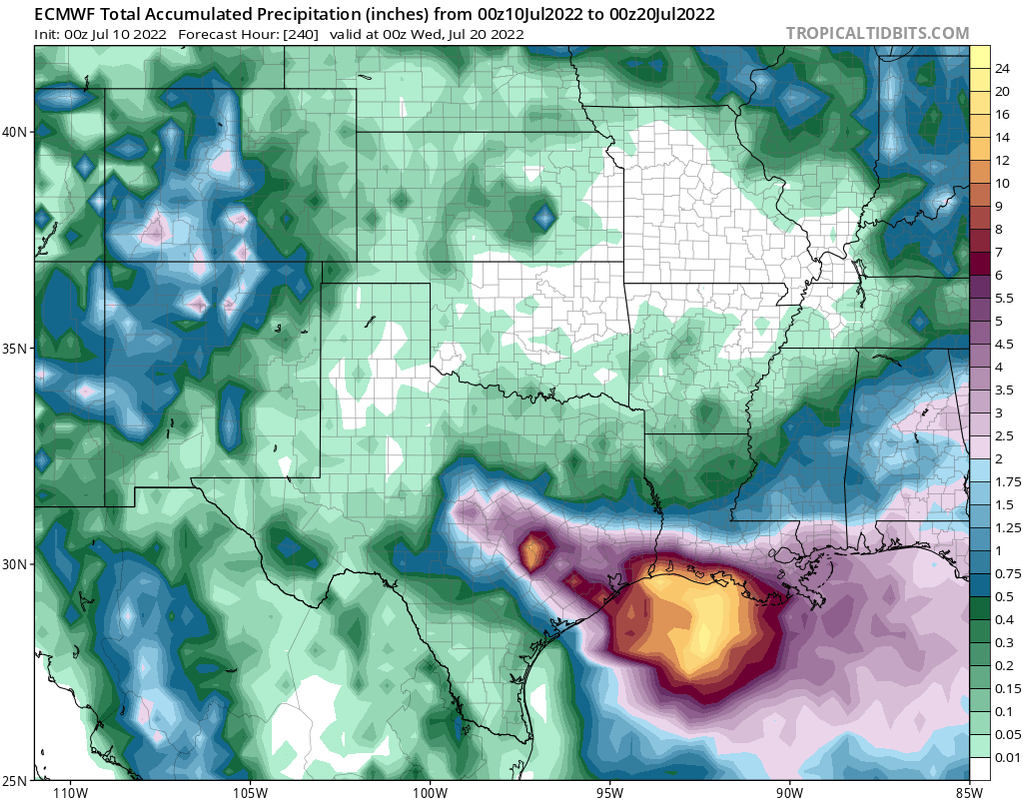
12z Euro has TS Danielle by 120 hours just offshore the MS/AL state line. Moving SSE and intensifying by 144 hrs. Interesting run shaping up
Edit: Looks to be moving back north into Mobile Bay by 150hrs, 992mb. Over 20" of rain showing up along the coast
Edit: Looks to be moving back north into Mobile Bay by 150hrs, 992mb. Over 20" of rain showing up along the coast
0 likes
-
BigB0882
- S2K Supporter

- Posts: 2292
- Joined: Thu Jul 03, 2003 12:08 am
- Location: Baton Rouge, LA
- Contact:
Re: Possible Development Near the Central Gulf Coast
Great timing as we are currently driving to Orange Beach. Lol
1 likes
Who is online
Users browsing this forum: Google Adsense [Bot], Iceresistance and 86 guests