Tropical Wave in Eastern Caribbean: (Is INVEST 95L)
Moderator: S2k Moderators
Forum rules

The posts in this forum are NOT official forecasts and should not be used as such. They are just the opinion of the poster and may or may not be backed by sound meteorological data. They are NOT endorsed by any professional institution or STORM2K. For official information, please refer to products from the National Hurricane Center and National Weather Service.
-
cycloneye

- Admin

- Posts: 149730
- Age: 69
- Joined: Thu Oct 10, 2002 10:54 am
- Location: San Juan, Puerto Rico
Tropical Wave in Eastern Caribbean: (Is INVEST 95L)
Post away for this wave that will bring a good deal of rain to some of the islands in the Eastern Caribbean. Will it be more than rain? We will find out.
2 likes
Visit the Caribbean-Central America Weather Thread where you can find at first post web cams,radars
and observations from Caribbean basin members Click Here
and observations from Caribbean basin members Click Here
-
Aric Dunn
- Category 5

- Posts: 21238
- Age: 43
- Joined: Sun Sep 19, 2004 9:58 pm
- Location: Ready for the Chase.
- Contact:
Re: Tropical Wave just East of Lesser Antilles
USTropics wrote:Current satellite loop of wave east of Caribbean with some model support for development:
https://i.ibb.co/s5F0JFL/60179453-1.gif
Currently it's under about 25kts of shear with dry subsidence in the vicinity. Low-level clouds are moving from NE to NW in loop above, so not much going on at the surface currently. It should track NW towards the Bahamas, where better conditions are modeled.
06z GFS shows an increase in vorticity in 96 hours, but a forecast of ~30-40 knots of shear keeps it in check. Shear forecasts past 72 hours aren't the best at verifying, so definitely something to keep an eye on:
https://i.imgur.com/W3PkJap.png
The NE part of the wave might be developing a circ. some strong inflow from the S into that cluster with some inflow from the north and NE as well. definitely needs to be watched. especially with the shear axis forecast to shift west with it.
Maybe a thread for this wave should be made now that there is some model support for it,
FYI the 12z GFS brings this wave into the eastern gulf and tries to start to develop it.


0 likes
Note: If I make a post that is brief. Please refer back to previous posts for the analysis or reasoning. I do not re-write/qoute what my initial post said each time.
If there is nothing before... then just ask
Space & Atmospheric Physicist, Embry-Riddle Aeronautical University,
I believe the sky is falling...
If there is nothing before... then just ask
Space & Atmospheric Physicist, Embry-Riddle Aeronautical University,
I believe the sky is falling...
-
cycloneye
- Admin
- Posts: 149730
- Age: 69
- Joined: Thu Oct 10, 2002 10:54 am
- Location: San Juan, Puerto Rico
Re: Tropical Wave just East of Lesser Antilles
From the San Juan NWS:
The weather pattern begins to change by Monday as the moisture
content associated with an active tropical wave, currently near 50W
longitude, gradually increases. Latest model guidance has trended a
little slower with the arrival of the tropical wave that now the low
to mid-level moisture content does not begin to increase
significantly until later Monday afternoon and evening. As a result,
scattered showers and isolated thunderstorms are expected to
gradually increase in coverage across the regional waters and affect
portions of the eastern half of Puerto Rico and the USVI during this
time frame. Additional showers and thunderstorms are expected across
western Puerto Rico during the afternoon hours as a result of
strong daytime heating and local effects.
Abundant moisture behind the tropical wave with precipitable
water content ranging from 2.00-2.40 inches across the region
will linger on Tuesday. Southeast steering wind flow will keep
showers and isolated thunderstorms streaming from the Caribbean
waters into the U.S. Virgin Islands and east/southeast sections
of Puerto Rio. Additional thunderstorms are forecast to develop
across much of PR through the day.
1 likes
Visit the Caribbean-Central America Weather Thread where you can find at first post web cams,radars
and observations from Caribbean basin members Click Here
and observations from Caribbean basin members Click Here
-
Aric Dunn
- Category 5
- Posts: 21238
- Age: 43
- Joined: Sun Sep 19, 2004 9:58 pm
- Location: Ready for the Chase.
- Contact:
Re: Tropical Wave just East of Lesser Antilles
The shear axis is moving west ahead of the wave. so as long as the wave does not speed up it will stay in a marginal shear environment giving it a chance to organize.

1 likes
Note: If I make a post that is brief. Please refer back to previous posts for the analysis or reasoning. I do not re-write/qoute what my initial post said each time.
If there is nothing before... then just ask
Space & Atmospheric Physicist, Embry-Riddle Aeronautical University,
I believe the sky is falling...
If there is nothing before... then just ask
Space & Atmospheric Physicist, Embry-Riddle Aeronautical University,
I believe the sky is falling...
-
Aric Dunn
- Category 5
- Posts: 21238
- Age: 43
- Joined: Sun Sep 19, 2004 9:58 pm
- Location: Ready for the Chase.
- Contact:
Re: Tropical Wave just East of Lesser Antilles
Wave axis is Tilting and vorticity is increasing large moisture envelop. has a decent shot to develop most likely once it gets north of PR.


2 likes
Note: If I make a post that is brief. Please refer back to previous posts for the analysis or reasoning. I do not re-write/qoute what my initial post said each time.
If there is nothing before... then just ask
Space & Atmospheric Physicist, Embry-Riddle Aeronautical University,
I believe the sky is falling...
If there is nothing before... then just ask
Space & Atmospheric Physicist, Embry-Riddle Aeronautical University,
I believe the sky is falling...
-
AnnularCane

- S2K Supporter

- Posts: 2964
- Joined: Thu Jun 08, 2006 9:18 am
- Location: Wytheville, VA
Re: Tropical Wave just East of Lesser Antilles
Beautiful wave...looks good in pink!  But I am wondering how attached we should get to this one.
3 likes
-
cycloneye
- Admin
- Posts: 149730
- Age: 69
- Joined: Thu Oct 10, 2002 10:54 am
- Location: San Juan, Puerto Rico
Re: Tropical Wave just East of Lesser Antilles
12z Euro has it.

0 likes
Visit the Caribbean-Central America Weather Thread where you can find at first post web cams,radars
and observations from Caribbean basin members Click Here
and observations from Caribbean basin members Click Here
-
Aric Dunn
- Category 5
- Posts: 21238
- Age: 43
- Joined: Sun Sep 19, 2004 9:58 pm
- Location: Ready for the Chase.
- Contact:
Re: Tropical Wave just East of Lesser Antilles
AnnularCane wrote:Beautiful wave...looks good in pink!
12z Euro 21 hours..

0 likes
Note: If I make a post that is brief. Please refer back to previous posts for the analysis or reasoning. I do not re-write/qoute what my initial post said each time.
If there is nothing before... then just ask
Space & Atmospheric Physicist, Embry-Riddle Aeronautical University,
I believe the sky is falling...
If there is nothing before... then just ask
Space & Atmospheric Physicist, Embry-Riddle Aeronautical University,
I believe the sky is falling...
-
Aric Dunn
- Category 5
- Posts: 21238
- Age: 43
- Joined: Sun Sep 19, 2004 9:58 pm
- Location: Ready for the Chase.
- Contact:
Re: Tropical Wave just East of Lesser Antilles
Euro finally develops it while recurving .
0 likes
Note: If I make a post that is brief. Please refer back to previous posts for the analysis or reasoning. I do not re-write/qoute what my initial post said each time.
If there is nothing before... then just ask
Space & Atmospheric Physicist, Embry-Riddle Aeronautical University,
I believe the sky is falling...
If there is nothing before... then just ask
Space & Atmospheric Physicist, Embry-Riddle Aeronautical University,
I believe the sky is falling...
-
Hurricaneman

- Category 5
- Posts: 7404
- Age: 45
- Joined: Tue Aug 31, 2004 3:24 pm
- Location: central florida
Re: Tropical Wave just East of Lesser Antilles
Depending on where the trough is next week the Carolinas to Bermuda may need to keep an eye on this feature
0 likes
-
crownweather

- S2K Supporter
- Posts: 602
- Age: 51
- Joined: Sat Aug 12, 2006 9:21 am
- Location: Sturbridge, Massachusetts
- Contact:
Re: Tropical Wave just East of Lesser Antilles
Last night's UKMET, today's Canadian and ICON models develop it. Only one that does not right now is the GFS model, although the GEFS model does hint at development.
1 likes
Rob Lightbown
Crown Weather Services
https://crownweather.com
Crown Weather Services
https://crownweather.com
-
cycloneye
- Admin
- Posts: 149730
- Age: 69
- Joined: Thu Oct 10, 2002 10:54 am
- Location: San Juan, Puerto Rico
Re: Tropical Wave just East of Lesser Antilles
Dang.

1 likes
Visit the Caribbean-Central America Weather Thread where you can find at first post web cams,radars
and observations from Caribbean basin members Click Here
and observations from Caribbean basin members Click Here
-
CyclonicFury

- Category 5
- Posts: 2038
- Age: 27
- Joined: Sun Jul 02, 2017 12:32 pm
- Location: NC
- Contact:
Re: Tropical Wave just East of Lesser Antilles
wxman57 wrote:Development chances are near zero. East Caribbean is too hostile at present. Might develop in the East Pacific late next week.
East Pacific? I don't see any model taking the vorticity signature of this wave to the EPAC. Instead, it seems like they take it to the SW Atlantic in a week or so.
3 likes
NCSU B.S. in Meteorology Class of 2021. Tropical weather blogger at http://www.cyclonicfury.com. My forecasts and thoughts are NOT official, for official forecasts please consult the National Hurricane Center.
-
Hurricaneman
- Category 5
- Posts: 7404
- Age: 45
- Joined: Tue Aug 31, 2004 3:24 pm
- Location: central florida
Re: Tropical Wave just East of Lesser Antilles
CyclonicFury wrote:wxman57 wrote:Development chances are near zero. East Caribbean is too hostile at present. Might develop in the East Pacific late next week.
East Pacific? I don't see any model taking the vorticity signature of this wave to the EPAC. Instead, it seems like they take it to the SW Atlantic in a week or so.
What I’m personally seeing is that the northern part of the wave possibly becomes a tropical cyclone off the east coast where things are favorable while the southern part develops in the EPAC from what I’m seeing in the models
0 likes
-
gatorcane

- S2K Supporter
- Posts: 23708
- Age: 48
- Joined: Sun Mar 13, 2005 3:54 pm
- Location: Boca Raton, FL
Re: Tropical Wave just East of Lesser Antilles
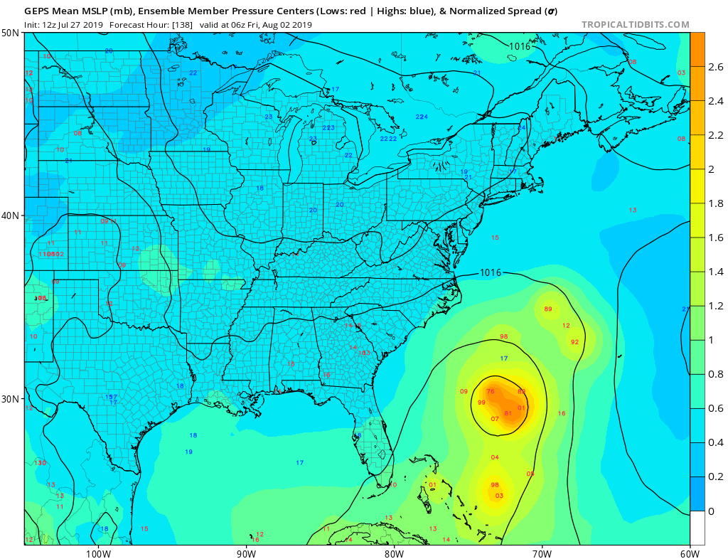
GEM ensembles are quite bullish on development between the US and Bermuda on the recurve. Note models have overdone troughiness over the US this summer:
0 likes
-
NotSparta

- Professional-Met

- Posts: 1677
- Age: 24
- Joined: Fri Aug 18, 2017 8:24 am
- Location: Naples, FL
- Contact:
Re: Tropical Wave just East of Lesser Antilles
wxman57 wrote:Development chances are near zero. East Caribbean is too hostile at present. Might develop in the East Pacific late next week.
It's going way too far north to reach the Pacific
0 likes
This post was probably an opinion of mine, and in no way is official. Please refer to http://www.hurricanes.gov for official tropical analysis and advisories.
My website, with lots of tropical wx graphics, including satellite and recon: http://cyclonicwx.com
My website, with lots of tropical wx graphics, including satellite and recon: http://cyclonicwx.com
-
SFLcane

- S2K Supporter
- Posts: 10281
- Age: 48
- Joined: Sat Jun 05, 2010 1:44 pm
- Location: Lake Worth Florida
Re: Tropical Wave just East of Lesser Antilles
Lol.. development chances near zero as wxman57 stated. 
0 likes
-
CyclonicFury
- Category 5
- Posts: 2038
- Age: 27
- Joined: Sun Jul 02, 2017 12:32 pm
- Location: NC
- Contact:
Re: Tropical Wave just East of Lesser Antilles
SFLcane wrote:Lol.. development chances near zero as wxman57 stated.
For right now, yes. This won't develop in the Caribbean.
However, some energy will break away and move northward, and could develop near the Bahamas in a week or so when it may encounter more favorable conditions. This idea is supported by the 12z ECMWF, EPS, ICON, CMC, NAVGEM and JMA models.
3 likes
NCSU B.S. in Meteorology Class of 2021. Tropical weather blogger at http://www.cyclonicfury.com. My forecasts and thoughts are NOT official, for official forecasts please consult the National Hurricane Center.

Re: Tropical Wave just East of Lesser Antilles
gatorcane wrote:GEM ensembles are quite bullish on development between the US and Bermuda on the recurve. Note models have overdone troughiness over the US this summer:
Considering a cold front made it all the way to central FL in July of all months, I can't imagine how the models are OVERDOING the troughs.
1 likes
-
CyclonicFury
- Category 5
- Posts: 2038
- Age: 27
- Joined: Sun Jul 02, 2017 12:32 pm
- Location: NC
- Contact:
Re: Tropical Wave just East of Lesser Antilles
floridasun78 wrote:CyclonicFury wrote:SFLcane wrote:Lol.. development chances near zero as wxman57 stated.
For right now, yes. This won't develop in the Caribbean.
However, some energy will break away and move northward, and could develop near the Bahamas in a week or so when it may encounter more favorable conditions. This idea is supported by the 12z ECMWF, EPS, ICON, CMC, NAVGEM and JMA models.
other td3? the way happen to td3
It could be like TD Three, but it could also be stronger or not form at all. You can't definitively say this far out.
0 likes
NCSU B.S. in Meteorology Class of 2021. Tropical weather blogger at http://www.cyclonicfury.com. My forecasts and thoughts are NOT official, for official forecasts please consult the National Hurricane Center.
Who is online
Users browsing this forum: No registered users and 178 guests