
I saw the thread in active for the B storm in the Pacific. It looks like there are two surges, one heading up now partially influenced by outflow, and then the mid or upper remnants which may fire off in the Gulf late weekend or early next week with some models tightening for a while on the way to Florida. We're about to get the first surge in the city. It looks like a spring time warm front or even a sea breeze, but those don't happen at 4:00 in the afternoon here. Notice also how the storms while progressing north are sort of rotating west. It's either the boundary of two air masses or a legit band from a non-formed system.
Radar:
https://radar.weather.gov/ridge/radar.p ... 1&loop=yes
Hurricane Visible Loop:
http://www.goes.noaa.gov/HURRLOOPS/huvsloop.html
Northern Gulf of Mexico Disturbance
Moderator: S2k Moderators
Forum rules

The posts in this forum are NOT official forecasts and should not be used as such. They are just the opinion of the poster and may or may not be backed by sound meteorological data. They are NOT endorsed by any professional institution or STORM2K. For official information, please refer to products from the National Hurricane Center and National Weather Service.
Northern Gulf of Mexico Disturbance
Last edited by tolakram on Tue Jun 06, 2017 11:26 am, edited 2 times in total.
Reason: Title change
Reason: Title change
0 likes

Re: Gulf of Mexico - June 2017
Is that area of moisture coming in over southern Mexico going to continue nne into the gulf?
0 likes
Re: Gulf of Mexico - June 2017
Nimbus wrote:Is that area of moisture coming in over southern Mexico going to continue nne into the gulf?
Several models are bringing mid and upper energy and consolidating into a closed low of varying degrees up to maybe a TS hit between Tampa and Sarasota. Who knows in early June?
0 likes

Re: Gulf of Mexico - June 2017
12z Euro has a closed low pressure forming over the extreme BOC as early as tomorrow night, strengthen some on Saturday-Sunday before it shows it weakening due to the stronger shear over the middle of the GOM.
3 likes
-
tropicwatch

- Category 5

- Posts: 3427
- Age: 62
- Joined: Sat Jun 02, 2007 10:01 am
- Location: The Villages, Florida
- Contact:
Re: Gulf of Mexico - June 2017
From the 8:02pm EDT Tropical Weather Discussion:
Expect a surface low to form over the Bay of Campeche Saturday, then move NW towards
southern Texas Sunday.
Sorry, didn't see this thread before posting in the Global Model Thread.
Expect a surface low to form over the Bay of Campeche Saturday, then move NW towards
southern Texas Sunday.
Sorry, didn't see this thread before posting in the Global Model Thread.
2 likes
Tropicwatch
Agnes 72', Eloise 75, Elena 85', Kate 85', Charley 86', Florence 88', Beryl 94', Dean 95', Erin 95', Opal 95', Earl 98', Georges 98', Ivan 2004', Arlene 2005', Dennis 2005', Ida 2009' Debby 2012' Irma 2017' Michael 2018'
Agnes 72', Eloise 75, Elena 85', Kate 85', Charley 86', Florence 88', Beryl 94', Dean 95', Erin 95', Opal 95', Earl 98', Georges 98', Ivan 2004', Arlene 2005', Dennis 2005', Ida 2009' Debby 2012' Irma 2017' Michael 2018'
Re: Gulf of Mexico - June 2017
WV shows potential drought relief for the FL peninsula. 12z QPF wasn't all that impressive showing the heaviest accumulation concentrations offshore. Of course the 5+ Day GFS has been pretty dismal anyway lately, and i would expect the rainfall amounts to go way up over the next few days as the model faces reality.
http://www.goes.noaa.gov/browsh3.html
http://www.goes.noaa.gov/browsh3.html
0 likes
Re: Gulf of Mexico - June 2017
And just like that last night's Euro dropped its earlier forecasts of development in the GOM, lol.
0 likes

Re: Western Gulf of Mexico Disturbance
https://twitter.com/MJVentrice/status/870605310586695680
"Calibrated ECMWF giving a 30% chance for a disturbance to briefly spin up o/the GoMexico during the next 3 days. Shear is going to be a prob"
"Calibrated ECMWF giving a 30% chance for a disturbance to briefly spin up o/the GoMexico during the next 3 days. Shear is going to be a prob"
0 likes
-
TheStormExpert
Re: Gulf of Mexico - June 2017
NDG wrote:And just like that last night's Euro dropped its earlier forecasts of development in the GOM, lol.
It seems we can't trust any global model beyond a couple of days so far this year.
0 likes
Re: Gulf of Mexico - June 2017
TheStormExpert wrote:NDG wrote:And just like that last night's Euro dropped its earlier forecasts of development in the GOM, lol.
It seems we can't trust any global model beyond a couple of days so far this year.
Yeah, good thing the Euro has an upgrade coming up, if I am not mistaken, because it has also been all over the place with very little consistency from run to run.
0 likes
-
johngaltfla

- Category 5
- Posts: 2073
- Joined: Sun Jul 10, 2005 9:17 pm
- Location: Sarasota County, FL
- Contact:
Re: Western Gulf of Mexico Disturbance
This is a tough month for the models to grasp usually before any closed low forms. Local mets are expecting a low chance of a TD developing but soaking rains Wednesday and Thursday in West Central and Central Florida. We need the drought relief, that's for sure.
1 likes
Re: Western Gulf of Mexico Disturbance
Development or no development this is great news for sure here in central and southern FL with the deep tropical moisture being pulled into our area.
1 likes
-
TheStormExpert
Re: Western Gulf of Mexico Disturbance
Most definitely happy about the potential of receiving possibly around 5" of rain. 
My concern is I hope this comes and goes by June 7th cause I'm headed to the Bahamas for about a week. What's your guys thoughts on what the weather might be there in the Abacos?
My concern is I hope this comes and goes by June 7th cause I'm headed to the Bahamas for about a week. What's your guys thoughts on what the weather might be there in the Abacos?
1 likes
Re: Western Gulf of Mexico Disturbance
TheStormExpert wrote:Most definitely happy about the potential of receiving possibly around 5" of rain.
My concern is I hope this comes and goes by June 7th cause I'm headed to the Bahamas for about a week. What's your guys thoughts on what the weather might be there in the Abacos?
It's not very far, so over the next 5-7 days for sure. Have fun by the way, and use some sunscreen if you get sunny days.
---------------------------
As guessed at yesterday, the GFS is more coming into line as shown with the results reflected in the 00z QPF. I don't know that anything is going to consolidate, but at least a few waves and surges of moisture should come out of this and cross the peninsula. Hopefully this won't be a lot of cloud cover and will actually include precipitation. Current prog from 00z (8pm last night EDT), upward of 7" in South FL, 3-5" upward through the central Peninsula. I figured it would catch up, but now it's about the details and specific, localized amounts that do fall between now and the end of next week.
http://www.wpc.ncep.noaa.gov/qpf/p168i.gif?1496410230
Also, it appears that rainfall will start today in some areas:
https://radar.weather.gov/ridge/Conus/s ... t_loop.php
0 likes
-
TheStormExpert
Re: Western Gulf of Mexico Disturbance
Steve wrote:TheStormExpert wrote:Most definitely happy about the potential of receiving possibly around 5" of rain.
My concern is I hope this comes and goes by June 7th cause I'm headed to the Bahamas for about a week. What's your guys thoughts on what the weather might be there in the Abacos?
It's not very far, so over the next 5-7 days for sure. Have fun by the way, and use some sunscreen if you get sunny days.
---------------------------
As guessed at yesterday, the GFS is more coming into line as shown with the results reflected in the 00z QPF. I don't know that anything is going to consolidate, but at least a few waves and surges of moisture should come out of this and cross the peninsula. Hopefully this won't be a lot of cloud cover and will actually include precipitation. Current prog from 00z (8pm last night EDT), upward of 7" in South FL, 3-5" upward through the central Peninsula. I figured it would catch up, but now it's about the details and specific, localized amounts that do fall between now and the end of next week.
http://www.wpc.ncep.noaa.gov/qpf/p168i.gif?1496410230
Also, it appears that rainfall will start today in some areas:
https://radar.weather.gov/ridge/Conus/s ... t_loop.php
Thanks! Hopefully I can get more sunny days than not. Been keeping close tabs with the GFS to see what it shows in terms of rain and cloud over is concerned and it looks like by next weekend around June 10th this mess may finally lift out and allow for a few full fledged sunny days where I'm headed.
1 likes
-
TheStormExpert
Re: Western Gulf of Mexico Disturbance
Shear wins this round! We'll try again within the next few weeks.
While the low should
dissipate over land tonight, the remnants of Beatriz are expected to
move over the southwestern Gulf of Mexico during the next day or
two, where current indications are that strong upper-level winds
should prevent re-development.
dissipate over land tonight, the remnants of Beatriz are expected to
move over the southwestern Gulf of Mexico during the next day or
two, where current indications are that strong upper-level winds
should prevent re-development.
0 likes
Re: Western Gulf of Mexico Disturbance
If the shear forecast holds there should be lots of moisture pulled up over north Florida and Georgia from the surface low. Wonder if this area makes it to active storms as an invest?
0 likes
-
lrak

- S2K Supporter

- Posts: 1770
- Age: 59
- Joined: Thu Jun 21, 2007 2:48 pm
- Location: Corpus Christi, TX
Re: Gulf of Mexico - June 2017
panamatropicwatch wrote:From the 8:02pm EDT Tropical Weather Discussion:
Expect a surface low to form over the Bay of Campeche Saturday, then move NW towards
southern Texas Sunday.
Sorry, didn't see this thread before posting in the Global Model Thread.
The model thread shows this going to Florida, why did they say it would move towards S. Tex?
0 likes
AKA karl
Also
Personal Forecast Disclaimer:
My posts on this forum are NOT official forecast and should not be used as such. My posts are my basic observations and are definitely not backed by any "well some" meteorological knowledge. For official information, please refer to the NHC and NWS products.
Also
Personal Forecast Disclaimer:
My posts on this forum are NOT official forecast and should not be used as such. My posts are my basic observations and are definitely not backed by any "well some" meteorological knowledge. For official information, please refer to the NHC and NWS products.
-
tropicwatch
- Category 5
- Posts: 3427
- Age: 62
- Joined: Sat Jun 02, 2007 10:01 am
- Location: The Villages, Florida
- Contact:
Re: Western Gulf of Mexico Disturbance
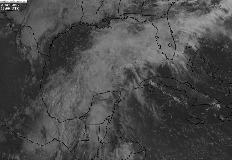
Looks like what low is left from Beatriz is starting to enter the BOC near Alvarado Mexico.
https://weather.msfc.nasa.gov/cgi-bin/get-goes?satellite=GOES-E%20CONUS&lat=20&lon=-92&type=Animation&info=vis&numframes=10
https://weather.msfc.nasa.gov/cgi-bin/get-goes?satellite=GOES-E%20CONUS&lat=20&lon=-92&type=Animation&info=vis&numframes=10
2 likes
Tropicwatch
Agnes 72', Eloise 75, Elena 85', Kate 85', Charley 86', Florence 88', Beryl 94', Dean 95', Erin 95', Opal 95', Earl 98', Georges 98', Ivan 2004', Arlene 2005', Dennis 2005', Ida 2009' Debby 2012' Irma 2017' Michael 2018'
Agnes 72', Eloise 75, Elena 85', Kate 85', Charley 86', Florence 88', Beryl 94', Dean 95', Erin 95', Opal 95', Earl 98', Georges 98', Ivan 2004', Arlene 2005', Dennis 2005', Ida 2009' Debby 2012' Irma 2017' Michael 2018'
-
TheStormExpert
Re: Western Gulf of Mexico Disturbance
Nimbus wrote:If the shear forecast holds there should be lots of moisture pulled up over north Florida and Georgia from the surface low. Wonder if this area makes it to active storms as an invest?
I could see the possibility of it getting a yellow circle by the NHC but likely nothing more.
0 likes
Who is online
Users browsing this forum: Ulf and 194 guests