Pouch P15L- SE of CV Islands (Is invest 93L)
Moderator: S2k Moderators
Forum rules

The posts in this forum are NOT official forecasts and should not be used as such. They are just the opinion of the poster and may or may not be backed by sound meteorological data. They are NOT endorsed by any professional institution or STORM2K. For official information, please refer to products from the National Hurricane Center and National Weather Service.
-
cycloneye

- Admin

- Posts: 149777
- Age: 69
- Joined: Thu Oct 10, 2002 10:54 am
- Location: San Juan, Puerto Rico
Pouch P15L- SE of CV Islands (Is invest 93L)
Let's see down the road how this one evolves..

0 likes
Visit the Caribbean-Central America Weather Thread where you can find at first post web cams,radars
and observations from Caribbean basin members Click Here
and observations from Caribbean basin members Click Here


-
cycloneye
- Admin
- Posts: 149777
- Age: 69
- Joined: Thu Oct 10, 2002 10:54 am
- Location: San Juan, Puerto Rico
Re: Big Wave about to emerge Africa
Outerbanker,this is the wave GFS had as a hurricane off Carolinas and then did the swing to Texas on next run.
0 likes
Visit the Caribbean-Central America Weather Thread where you can find at first post web cams,radars
and observations from Caribbean basin members Click Here
and observations from Caribbean basin members Click Here
-
cycloneye
- Admin
- Posts: 149777
- Age: 69
- Joined: Thu Oct 10, 2002 10:54 am
- Location: San Juan, Puerto Rico
Re: Big Wave about to emerge Africa
You can track the 12z GFS until the GOM but doesn't go bonkers with it. What I notice is very low pressures in the Caribbean and MDR as advertised by ECMWF.
12z GFS Loop
12z GFS Loop
0 likes
Visit the Caribbean-Central America Weather Thread where you can find at first post web cams,radars
and observations from Caribbean basin members Click Here
and observations from Caribbean basin members Click Here
-
cycloneye
- Admin
- Posts: 149777
- Age: 69
- Joined: Thu Oct 10, 2002 10:54 am
- Location: San Juan, Puerto Rico
Re:
Gustywind wrote:Hey Cyloneye, when do you think that this big wave could be labelled as a pouch?
That is up to the predict folks to decide as they look at the data when is going to be a pouch in this case will be P15L.
0 likes
Visit the Caribbean-Central America Weather Thread where you can find at first post web cams,radars
and observations from Caribbean basin members Click Here
and observations from Caribbean basin members Click Here
-
Gustywind

- Category 5

- Posts: 12334
- Joined: Mon Sep 03, 2007 7:29 am
- Location: Baie-Mahault, GUADELOUPE
Re: Re:
cycloneye wrote:Gustywind wrote:Hey Cyloneye, when do you think that this big wave could be labelled as a pouch?
That is up to the predict folks to decide as they look at the data when is going to be a pouch in this case will be P15L.
Thanks
0 likes
-
Gustywind
- Category 5
- Posts: 12334
- Joined: Mon Sep 03, 2007 7:29 am
- Location: Baie-Mahault, GUADELOUPE
M. Ressler, The Weather Channel
Aug 7, 2011 4:55 pm ET
Tropics Watch: Daily map analysis
ATLANTIC BASIN
Another tropical wave is evident over western Africa and should emerge over the far eastern Atlantic within a couple of days. It already has some well-defined spin and thunderstorm activity, and some models suggest eventual development is possible over the tropical Atlantic during the next week, but it is too soon to be confident on whether that will actually occur.
0 likes
-
cycloneye
- Admin
- Posts: 149777
- Age: 69
- Joined: Thu Oct 10, 2002 10:54 am
- Location: San Juan, Puerto Rico
Re:
Gustywind wrote:Why the litle has changed?
Modified title to reflect wave that is not as huge as first thought by looking at recent sat pics like the one at first post.Circulation is at the southern end of wave. As soon the predict team designates it as a pouch,I will again modify the title.
0 likes
Visit the Caribbean-Central America Weather Thread where you can find at first post web cams,radars
and observations from Caribbean basin members Click Here
and observations from Caribbean basin members Click Here
-
Gustywind
- Category 5
- Posts: 12334
- Joined: Mon Sep 03, 2007 7:29 am
- Location: Baie-Mahault, GUADELOUPE
Re: Re:
cycloneye wrote:Gustywind wrote:Why the litle has changed?
Modified title to reflect wave that is not as huge as first thought by looking at recent sat pics like the one at first post. As soon the predict team designates it as a pouch,)I will again modify the title.
Ok thanks Cycloneye, i was wondering if another twave were appearing on Africa
0 likes
-
Aric Dunn
- Category 5
- Posts: 21238
- Age: 43
- Joined: Sun Sep 19, 2004 9:58 pm
- Location: Ready for the Chase.
- Contact:
Re:
AJC3 wrote:It appears as if that large outflow boundary "snowplowing" it's way through Mali/Burkina Faso/Cote D'Ivoire is associated with a decent easterly speed surge. It looks like it will probably ram into the broad area of vorticity associated with the t-wave off the African coast.
exactly. we see it a couple times a year were a system like 92l will sit basically in place just off the african coast and not develop till the energy from the trailing wave begins to over run it.
0 likes
Note: If I make a post that is brief. Please refer back to previous posts for the analysis or reasoning. I do not re-write/qoute what my initial post said each time.
If there is nothing before... then just ask
Space & Atmospheric Physicist, Embry-Riddle Aeronautical University,
I believe the sky is falling...
If there is nothing before... then just ask
Space & Atmospheric Physicist, Embry-Riddle Aeronautical University,
I believe the sky is falling...
-
leaf blower

- Tropical Low

- Posts: 39
- Joined: Mon Jul 21, 2008 8:01 am
Re: Wave in West Africa
The Cape Verde season about to kick off, Plenty more action heading West across Africa
http://www.sat24.com/af
http://www.sat24.com/af
0 likes
-
cycloneye
- Admin
- Posts: 149777
- Age: 69
- Joined: Thu Oct 10, 2002 10:54 am
- Location: San Juan, Puerto Rico
Re: Wave emerging West Africa
The wave in front ex 92L also known as Pouch P14L has moisten the air in a big way that this wave emerging can avoid the dry air.

Uploaded by imageshack.us
Uploaded by imageshack.us
0 likes
Visit the Caribbean-Central America Weather Thread where you can find at first post web cams,radars
and observations from Caribbean basin members Click Here
and observations from Caribbean basin members Click Here
-
cycloneye
- Admin
- Posts: 149777
- Age: 69
- Joined: Thu Oct 10, 2002 10:54 am
- Location: San Juan, Puerto Rico
Re: Wave SSE of CV Islands
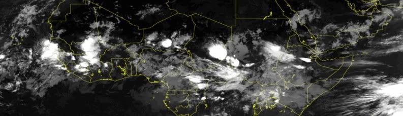
This thing behind ex 92L has a nice circulation. I say is a thing because it has not been designated yet as a pouch or a wave.
0 likes
Visit the Caribbean-Central America Weather Thread where you can find at first post web cams,radars
and observations from Caribbean basin members Click Here
and observations from Caribbean basin members Click Here
-
Blown Away

- S2K Supporter

- Posts: 10253
- Joined: Wed May 26, 2004 6:17 am
Re: Disturbed weather SSE of CV Islands
I agree Luis, ex-92L has moistened its path, exiting Africa at a bit higher latitude, some model support w/ possible building BH, and already has a cyclonic spin. Bold prediction, this area will become Franklin, brush the Caribbean, and landfall in the CONUS as a hurricane, of course this is only my opinion.
0 likes
Hurricane Eye Experience: David 79, Irene 99, Frances 04, Jeanne 04, Wilma 05… Hurricane Brush Experience: Andrew 92, Erin 95, Floyd 99, Matthew 16, Irma 17, Ian 22, Nicole 22…


Re: Disturbed weather SSE of CV Islands
Not sure which area they are developing (EX 92L or this), but the CMC, GFS, and NOGAPS all like developing something out of the eastern Atlantic to various degrees in the next week. Looking more closely, it looks like the GFS develops Ex 92L and the CMC develops this area.
The weather channel guy said that the sounding from west Africa showed that this wave did not have as impressive a signature in the atmosphere as Ex 92L, but not having firsthand access to the data, I don't put a great deal of stock in that by itself.
The weather channel guy said that the sounding from west Africa showed that this wave did not have as impressive a signature in the atmosphere as Ex 92L, but not having firsthand access to the data, I don't put a great deal of stock in that by itself.
0 likes
Who is online
Users browsing this forum: No registered users and 165 guests