ATL: INVEST 94L - Personal Forecasts
Moderator: S2k Moderators
Forum rules

The posts in this forum are NOT official forecasts and should not be used as such. They are just the opinion of the poster and may or may not be backed by sound meteorological data. They are NOT endorsed by any professional institution or STORM2K. For official information, please refer to products from the National Hurricane Center and National Weather Service.

Re: ATL: INVEST 94L - Personal Forecasts

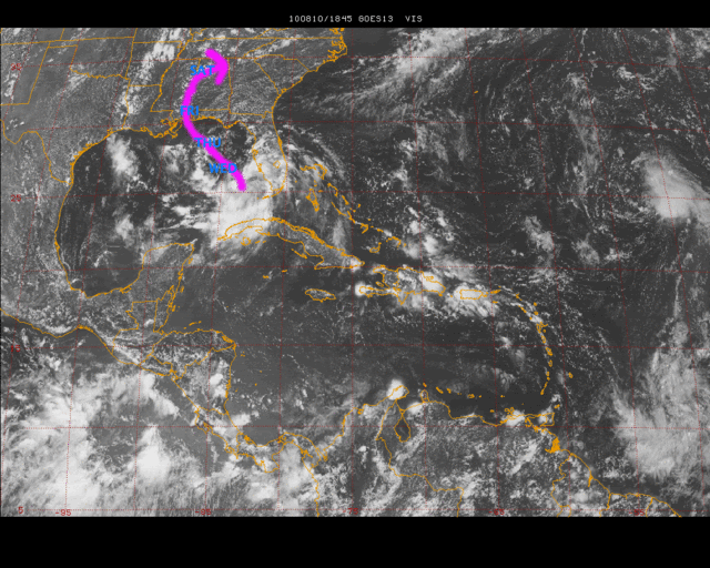
Uploaded with ImageShack.us
The posts in this forum are NOT official forecast and should not be used as such. They are just the opinion of the poster and may or may not be backed by sound meteorological data. They are NOT endorsed by any professional institution or storm2k.org. For official information, please refer to the NHC and NWS products.
i think this will make landfall between 50-90 mph.
Last edited by lebron23 on Tue Aug 10, 2010 2:43 pm, edited 1 time in total.
0 likes
-
Extremeweatherguy

- Category 5

- Posts: 11095
- Joined: Mon Oct 10, 2005 8:13 pm
- Location: Florida
Re: ATL: INVEST 94L - Personal Forecasts
Here is my initial forecast for 94L..
WED 12pm: 45mph
THU 12pm: 60mph
FRI 12pm: 70mph
SAT 12pm: 35mph
I believe that 94L will move slower than the models currently predict and thus will feel the weakness further east. Landfall should be somewhere near the MS/AL border as a high-end TS or low-end Hurricane. If the storm moves faster than expected, the landfall location will shift west, and if it moves slower, the landfall location will shift east. The speed of the storm will also impact landfall strength. A faster storm will be weaker and a slower storm will be stronger.
The posts in this forum are NOT official forecast and should not be used as such. They are just the opinion of the poster and may or may not be backed by sound meteorological data. They are NOT endorsed by any professional institution or storm2k.org. For official information, please refer to the NHC and NWS products.
0 likes

Re: ATL: INVEST 94L - Personal Forecasts
lebron23 wrote:
Uploaded with ImageShack.us
The posts in this forum are NOT official forecast and should not be used as such. They are just the opinion of the poster and may or may not be backed by sound meteorological data. They are NOT endorsed by any professional institution or storm2k.org. For official information, please refer to the NHC and NWS products.
i think this will make landfall between 50-90 mph.
No offense, lebron23, but I really don't like this track - right at me!
0 likes
-
Extremeweatherguy
- Category 5
- Posts: 11095
- Joined: Mon Oct 10, 2005 8:13 pm
- Location: Florida
Re: ATL: INVEST 94L - Personal Forecasts
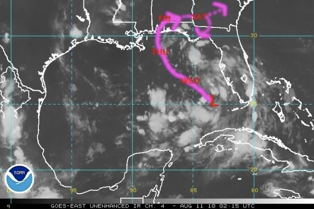
11pm ET 8/10/10 Update:
WED AFTN: 45mph
THU AFTN: 55mph
LANDFALL: 60mph
FRI AFTN: 45mph
SAT AFTN: 35mph
Changes from the last forecast..
My latest forecast is slightly faster than the previous forecast and also brings the center ashore slightly further to the east. The track once inland also represents more of a rightward bend. Intensity-wise, I am forecasting a weaker system at landfall than with my initial update this afternoon.
My thoughts as of this evening..
Tropical Depression #5 continues to look ragged this evening, and has yet to consolidate a single and definite lowest pressure center. However, I do believe that the system will slowly get its act together over the next 24-48 hours and likely strengthen into a moderate to strong tropical storm by landfall. At this point I am not expecting a hurricane, but the possibility cannot be ruled out. IMO, there is a 15% chance of a category 1 hurricane at landfall and a <5% chance of a category 2 or greater hurricane at landfall.
In terms of track, I continue to stick along the right edge of guidance (close to the 00z BAMS and BAMM solutions), predicting a landfall between the AL/MS and AL/FL borders Friday morning followed by a move inland and a gradual turn towards the NE and then ENE. This is only a moderate confidence forecast though. Center relocations and changes in forward speed will have large impacts on where this ultimately goes. At this point, everyone from the FL Big Bend to the upper TX coast needs to keep a watchful eye on this slowly organizing cyclone.
The posts in this forum are NOT official forecast and should not be used as such. They are just the opinion of the poster and may or may not be backed by sound meteorological data. They are NOT endorsed by any professional institution or storm2k.org. For official information, please refer to the NHC and NWS products.
1:09AM ET edit - After looking at more data, I have decided to reduce the peak forecast intensity by 5mph and also reduce hurricane chances.
-------------------------------------------------------------------------------------------------------
0 likes
-
Extremeweatherguy
- Category 5
- Posts: 11095
- Joined: Mon Oct 10, 2005 8:13 pm
- Location: Florida
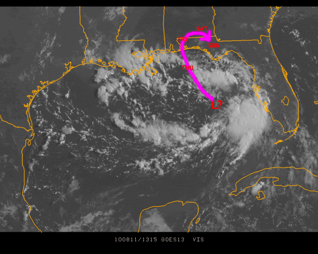
After reviewing the latest satellite, radar and model trends this morning, I have once again updated my forecast. Here is my latest take on the situation...
Track: http://i43.photobucket.com/albums/e371/ ... track3.gif
10am 8/11/10 Update:
CURRENT: 30mph
THU AM: 40mph
FRI AM: 30mph
SAT AM: 25mph (remnant low)
SUN AM: 25mph (remnant low)
Discussion:
Tropical Depression #5 looks pathetic this morning. The system has no definite center and deep convection continues to remain absent. With only 24-36 hours left until landfall, the chances of significant strengthening have dropped significantly. A weak tropical storm still appears possible though if this can get its act together at the last minute, but the chances of reaching a category 1 hurricane have now fallen to just 1% (or less).
In terms of the track, anything is possible. The general motion will be towards the northwest, but with no definite center to speak of right now, the exact "point" at which the system comes ashore is somewhat subjective. If a more definite center takes shape, then making a more precise track and landfall point will become much easier. In the long-term, there remains a small chance that the remnant low could try and move back towards the Gulf and re-develop as seen on the GFS, but for now the much more likely scenario still appears to be a quick death over the southeast USA during the weekend with no regeneration.
The posts in this forum are NOT official forecast and should not be used as such. They are just the opinion of the poster and may or may not be backed by sound meteorological data. They are NOT endorsed by any professional institution or storm2k.org. For official information, please refer to the NHC and NWS products.
2:45pm ET update - This system continues to look really bad this afternoon, and I am starting to think it may never reach TS status. More likely than not this will remain a depression up until landfall. It might even dissipate completely. Something else to note is that the latest run of the GFS no longer shows a regeneration scenario next week..which is good news.
0 likes
Who is online
Users browsing this forum: No registered users and 164 guests