
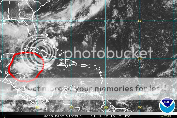
Seems to really be popping this morning. Any model support for something in the near future?
http://www.ssd.noaa.gov/goes/east/carb/avn-l.jpg
Caribbean Activity
Moderator: S2k Moderators
Forum rules

The posts in this forum are NOT official forecasts and should not be used as such. They are just the opinion of the poster and may or may not be backed by sound meteorological data. They are NOT endorsed by any professional institution or STORM2K. For official information, please refer to products from the National Hurricane Center and National Weather Service.
Caribbean Activity
0 likes
-
Air Force Met
- Military Met

- Posts: 4372
- Age: 57
- Joined: Tue Jul 08, 2003 9:30 am
- Location: Roan Mountain, TN
Re: Caribbean Activity
N2FSU wrote:Seems to really be popping this morning. Any model support for something in the near future?
http://www.ssd.noaa.gov/goes/east/carb/avn-l.jpg
Yes...this is what...I think...the EURO is trying to develop. You will notice that by tomorrow night...there is something in that area...and this is what the Euro moves towards Tx late next week.

0 likes


Yeah I agree with AFM this is the region that is currently being developed by the ECM, a wave just to the east of this region I think as well to hlep prop things up.
Indeed that ECM looks very close to a similar evolution we saw with Alex...slower development though this time round if it were to do anything.
Indeed that ECM looks very close to a similar evolution we saw with Alex...slower development though this time round if it were to do anything.
0 likes
Personal Forecast Disclaimer:
The posts in this forum are NOT official forecast and should not be used as such. They are just the opinion of the poster and may or may not be backed by sound meteorological data. They are NOT endorsed by any professional institution or storm2k.org. For official information, please refer to the NHC and NWS products
The posts in this forum are NOT official forecast and should not be used as such. They are just the opinion of the poster and may or may not be backed by sound meteorological data. They are NOT endorsed by any professional institution or storm2k.org. For official information, please refer to the NHC and NWS products
Just saw a post on another forum which shows the GFS is forecasting much lower than normal pressure in the W.Gulf and S.BoC in 120hrs, not that much different from the timing on the ECM developing the system it does on its 0z run.
0 likes
Personal Forecast Disclaimer:
The posts in this forum are NOT official forecast and should not be used as such. They are just the opinion of the poster and may or may not be backed by sound meteorological data. They are NOT endorsed by any professional institution or storm2k.org. For official information, please refer to the NHC and NWS products
The posts in this forum are NOT official forecast and should not be used as such. They are just the opinion of the poster and may or may not be backed by sound meteorological data. They are NOT endorsed by any professional institution or storm2k.org. For official information, please refer to the NHC and NWS products
-
floridasun78
- Category 5

- Posts: 3755
- Joined: Sun May 17, 2009 10:16 pm
- Location: miami fl
-
weatherSnoop

- S2K Supporter

- Posts: 702
- Age: 63
- Joined: Wed Oct 09, 2002 10:06 pm
- Location: Tampa, FL
- Contact:
-
weatherSnoop
- S2K Supporter
- Posts: 702
- Age: 63
- Joined: Wed Oct 09, 2002 10:06 pm
- Location: Tampa, FL
- Contact:

Re: Caribbean Activity
HURAKAN wrote:
The disturbance near Colombia has a strong vorticity
Isn't that vorticity related to the semipermanent Colombia-Panama low?
0 likes
-
HURAKAN

- Professional-Met

- Posts: 46084
- Age: 39
- Joined: Thu May 20, 2004 4:34 pm
- Location: Key West, FL
- Contact:
Re: Caribbean Activity
Macrocane wrote:HURAKAN wrote:
The disturbance near Colombia has a strong vorticity
Isn't that vorticity related to the semipermanent Colombia-Panama low?
Possibly, but since convection is flaring over water, it needs to be watched.
0 likes


-
KFDM Meteorologist

- Professional-Met
- Posts: 1314
- Joined: Tue May 16, 2006 9:52 pm
- Location: Upper Texas Coast/Orange County
Looks like the ECM is forecasting nearly an exactly same steering currents, it would make a lot of sense given the broad synoptic pattern isn't really going to shift to much overall.
0 likes
Personal Forecast Disclaimer:
The posts in this forum are NOT official forecast and should not be used as such. They are just the opinion of the poster and may or may not be backed by sound meteorological data. They are NOT endorsed by any professional institution or storm2k.org. For official information, please refer to the NHC and NWS products
The posts in this forum are NOT official forecast and should not be used as such. They are just the opinion of the poster and may or may not be backed by sound meteorological data. They are NOT endorsed by any professional institution or storm2k.org. For official information, please refer to the NHC and NWS products

-
KFDM Meteorologist
- Professional-Met
- Posts: 1314
- Joined: Tue May 16, 2006 9:52 pm
- Location: Upper Texas Coast/Orange County
xironman, yep more or less. I'd be surprised if it took the exact same track as Alex, there will be some differences but the broad evolution of the upper pattern over North America looks somewhat similar IMO.
0 likes
Personal Forecast Disclaimer:
The posts in this forum are NOT official forecast and should not be used as such. They are just the opinion of the poster and may or may not be backed by sound meteorological data. They are NOT endorsed by any professional institution or storm2k.org. For official information, please refer to the NHC and NWS products
The posts in this forum are NOT official forecast and should not be used as such. They are just the opinion of the poster and may or may not be backed by sound meteorological data. They are NOT endorsed by any professional institution or storm2k.org. For official information, please refer to the NHC and NWS products
Who is online
Users browsing this forum: No registered users and 255 guests