Wave in Caribbean

This is the general tropical discussion area. Anyone can take their shot at predicting a storms path.

Moderator: S2k Moderators

Forum rules

The posts in this forum are NOT official forecasts and should not be used as such. They are just the opinion of the poster and may or may not be backed by sound meteorological data. They are NOT endorsed by any professional institution or STORM2K. For official information, please refer to products from the National Hurricane Center and National Weather Service.

Help Support Storm2K
Message
Author
User avatar
cycloneye
Admin
Admin
Posts: 145568
Age: 68
Joined: Thu Oct 10, 2002 10:54 am
Location: San Juan, Puerto Rico

Wave in Caribbean

#1 Postby cycloneye » Wed Jun 02, 2010 7:25 am

Image

Is not unheard to see something develop in June at that part of the basin as we have seen in past seasons.Here is what I see as a strong wave but mainly below 10N latitud.Lets keep an eye on this as shear looks to not be strong in that area.

8:05 AM EDT discussion.


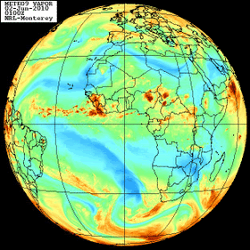
TROPICAL WAVE PREVIOUSLY ALONG 20W HAS BEEN RELOCATED FARTHER E
ALONG 15W S OF 10N MOVING W 10-15 KT. RELOCATION IS BASED ON
ANALYSIS OF LONG TERM SATELLITE IMAGERY AND MODEL DATA
INDICATING THE WAVE LOCATION NEAR 15W. A RELATIVE VORTICITY
MAXIMUM IS NOTED NEAR THE WAVE AXIS. WAVE IS ALSO EMBEDDED IN A
DEEP LAYER MOISTURE MAXIMUM EVIDENT IN TOTAL PRECIPITABLE WATER
IMAGERY. A LARGE AREA OF CONVECTION ACCOMPANIES THE WAVE.
SCATTERED STRONG CONVECTION IS FROM 3N-11N BETWEEN 12W-20W
0 likes   
Visit the Caribbean-Central America Weather Thread where you can find at first post web cams,radars
and observations from Caribbean basin members Click Here

User avatar
cycloneye
Admin
Admin
Posts: 145568
Age: 68
Joined: Thu Oct 10, 2002 10:54 am
Location: San Juan, Puerto Rico

Re: Strong Tropical Wave just emerged Africa

#2 Postby cycloneye » Wed Jun 02, 2010 7:31 am

Image

Image
0 likes   
Visit the Caribbean-Central America Weather Thread where you can find at first post web cams,radars
and observations from Caribbean basin members Click Here

User avatar
brunota2003
S2K Supporter
S2K Supporter
Posts: 9476
Age: 34
Joined: Sat Jul 30, 2005 9:56 pm
Location: Stanton, KY...formerly Havelock, NC
Contact:

#3 Postby brunota2003 » Wed Jun 02, 2010 7:31 am

Will be interesting to see how far west it can go before it "poofs" (or if it even does so). Definitely is way south though, but as June/July progresses, would expect that these waves will start to inch toward being over 10N.
0 likes   

User avatar
srainhoutx
S2K Supporter
S2K Supporter
Posts: 6919
Age: 67
Joined: Sun Jan 14, 2007 11:34 am
Location: Haywood County, NC
Contact:

Re: Strong Tropical Wave just emerged Africa

#4 Postby srainhoutx » Wed Jun 02, 2010 8:00 am

SAL may very well hinder development with this disturbance. Regardless, in a hyper active season that many are expecting it bears watching.
0 likes   
Carla/Alicia/Jerry(In The Eye)/Michelle/Charley/Ivan/Dennis/Katrina/Rita/Wilma/Ike/Harvey

Member: National Weather Association
Wx Infinity Forums
http://wxinfinity.com/index.php

Facebook.com/WeatherInfinity
Twitter @WeatherInfinity

User avatar
cycloneye
Admin
Admin
Posts: 145568
Age: 68
Joined: Thu Oct 10, 2002 10:54 am
Location: San Juan, Puerto Rico

Re: Strong Tropical Wave just emerged Africa

#5 Postby cycloneye » Wed Jun 02, 2010 1:24 pm

Here is a panoramic view of the wave.Is embedded in the ITCZ and below 10N and because of those factors,I dont see it getting better organized.But seeing this on early June is cause for concern as it may signal an active CV season.

Image
0 likes   
Visit the Caribbean-Central America Weather Thread where you can find at first post web cams,radars
and observations from Caribbean basin members Click Here

User avatar
KWT
Category 5
Category 5
Posts: 31415
Joined: Tue Aug 17, 2004 11:02 am
Location: UK!!!

#6 Postby KWT » Wed Jun 02, 2010 2:00 pm

It probably won't go poof down that far south, esp with the MDR anomalies meaning temps are pretty much as high as you'd expect for late July by now...

That being said there are probably factors that will hold everything in check for now...this is the first warning shot though and I think we will probably see something from this area in July, esp with the African Wave train being so strong this year.

Actually, this wave has if anything strengthened over water looking at the loop...
0 likes   
Personal Forecast Disclaimer:
The posts in this forum are NOT official forecast and should not be used as such. They are just the opinion of the poster and may or may not be backed by sound meteorological data. They are NOT endorsed by any professional institution or storm2k.org. For official information, please refer to the NHC and NWS products

User avatar
HURAKAN
Professional-Met
Professional-Met
Posts: 46086
Age: 38
Joined: Thu May 20, 2004 4:34 pm
Location: Key West, FL
Contact:

#7 Postby HURAKAN » Wed Jun 02, 2010 2:11 pm

Image

Loop
0 likes   

User avatar
KWT
Category 5
Category 5
Posts: 31415
Joined: Tue Aug 17, 2004 11:02 am
Location: UK!!!

#8 Postby KWT » Wed Jun 02, 2010 2:13 pm

If it holds for another 12-24hrs they may well invest this system, if only because its rather unusual to have a good looking wave quite this early that strengthens over the sea...
0 likes   
Personal Forecast Disclaimer:
The posts in this forum are NOT official forecast and should not be used as such. They are just the opinion of the poster and may or may not be backed by sound meteorological data. They are NOT endorsed by any professional institution or storm2k.org. For official information, please refer to the NHC and NWS products

User avatar
Category 5
Category 5
Category 5
Posts: 10074
Age: 35
Joined: Sun Feb 11, 2007 10:00 pm
Location: New Brunswick, NJ
Contact:

Re: Strong Tropical Wave just emerged Africa

#9 Postby Category 5 » Wed Jun 02, 2010 2:19 pm

That's damn impressive for June 2nd, and like KWT said it's far enough south to avoid the very hostile conditions (so far) that make June almost completely dead this far east. Right now though it still seems like a long shot.
0 likes   
Image
"GAME SET MATCH GIANTS WILL WIN THE NFC EAST and have a FIRST ROUND BYE with a win next week!!!" - StormingB81, the Giants lost, and did not win the NFC east.

IvanSurvivor
Tropical Storm
Tropical Storm
Posts: 152
Joined: Wed Aug 20, 2008 12:12 am
Location: Pensacola Florida (Warrington)

#10 Postby IvanSurvivor » Wed Jun 02, 2010 2:20 pm

How common is it for a storm to form below 10N? Examples of storms in the past?
0 likes   

User avatar
Category 5
Category 5
Category 5
Posts: 10074
Age: 35
Joined: Sun Feb 11, 2007 10:00 pm
Location: New Brunswick, NJ
Contact:

Re:

#11 Postby Category 5 » Wed Jun 02, 2010 2:22 pm

IvanSurvivor wrote:How common is it for a storm to form below 10N? Examples of storms in the past?


Off the top of my head Ivan in 04 comes to mind. Its not common but it does happen.
0 likes   
Image
"GAME SET MATCH GIANTS WILL WIN THE NFC EAST and have a FIRST ROUND BYE with a win next week!!!" - StormingB81, the Giants lost, and did not win the NFC east.

User avatar
KWT
Category 5
Category 5
Posts: 31415
Joined: Tue Aug 17, 2004 11:02 am
Location: UK!!!

#12 Postby KWT » Wed Jun 02, 2010 2:29 pm

I wouldn't expect development but I think what it shows is that later in the seasons conditions will be primed for some easterly CV action.
0 likes   
Personal Forecast Disclaimer:
The posts in this forum are NOT official forecast and should not be used as such. They are just the opinion of the poster and may or may not be backed by sound meteorological data. They are NOT endorsed by any professional institution or storm2k.org. For official information, please refer to the NHC and NWS products

User avatar
wx247
S2K Supporter
S2K Supporter
Posts: 14279
Age: 41
Joined: Wed Feb 05, 2003 10:35 pm
Location: Monett, Missouri
Contact:

#13 Postby wx247 » Wed Jun 02, 2010 2:34 pm

Well, it is something to observe and monitor on the satellite though. I figured that it might have gone poof by now, but so far... not the case. Of course its connections with the ITCZ have helped sustain it I am sure.
0 likes   
Personal Forecast Disclaimer:
The posts in this forum are NOT official forecast and should not be used as such. They are just the opinion of the poster and may or may not be backed by sound meteorological data. They are NOT endorsed by any professional institution or storm2k.org. For official information, please refer to the NHC and NWS products.

User avatar
HURAKAN
Professional-Met
Professional-Met
Posts: 46086
Age: 38
Joined: Thu May 20, 2004 4:34 pm
Location: Key West, FL
Contact:

#14 Postby HURAKAN » Wed Jun 02, 2010 2:40 pm

Climatology tells you not to expect development but for me, this is just a preview of what is coming!
0 likes   

User avatar
cycloneye
Admin
Admin
Posts: 145568
Age: 68
Joined: Thu Oct 10, 2002 10:54 am
Location: San Juan, Puerto Rico

Re: Strong Tropical Wave just emerged Africa

#15 Postby cycloneye » Wed Jun 02, 2010 2:40 pm

Here is the standard 6 hour intervals pic by NHC of the Eastern Atlantic.

Image
0 likes   
Visit the Caribbean-Central America Weather Thread where you can find at first post web cams,radars
and observations from Caribbean basin members Click Here

User avatar
KWT
Category 5
Category 5
Posts: 31415
Joined: Tue Aug 17, 2004 11:02 am
Location: UK!!!

Re:

#16 Postby KWT » Wed Jun 02, 2010 2:46 pm

wx247 wrote:Well, it is something to observe and monitor on the satellite though. I figured that it might have gone poof by now, but so far... not the case. Of course its connections with the ITCZ have helped sustain it I am sure.


Yeah the ITCZ is of course going to help this system, that being said SST's right now that far south would support a system if it came off lifesupport of the ITCZ. Its just whether SAL would be a big issue or not really, I suspect at this time of year it would be a big issue.
0 likes   
Personal Forecast Disclaimer:
The posts in this forum are NOT official forecast and should not be used as such. They are just the opinion of the poster and may or may not be backed by sound meteorological data. They are NOT endorsed by any professional institution or storm2k.org. For official information, please refer to the NHC and NWS products

User avatar
cycloneye
Admin
Admin
Posts: 145568
Age: 68
Joined: Thu Oct 10, 2002 10:54 am
Location: San Juan, Puerto Rico

Re: Strong Tropical Wave in Eastern Atlantic

#17 Postby cycloneye » Wed Jun 02, 2010 2:50 pm

Speaking of the Sal,is to the north of the wave so right now is not a detriment factor.

Image
0 likes   
Visit the Caribbean-Central America Weather Thread where you can find at first post web cams,radars
and observations from Caribbean basin members Click Here

bob rulz
Category 5
Category 5
Posts: 1704
Age: 35
Joined: Sat Jan 28, 2006 7:30 pm
Location: Salt Lake City, Utah

#18 Postby bob rulz » Wed Jun 02, 2010 2:54 pm

If the storm were to develop though it would likely detach from the ITCZ and move north, and therefore closer to the SAL.
0 likes   

User avatar
WeatherLovingDoc
S2K Supporter
S2K Supporter
Posts: 453
Joined: Fri Sep 05, 2008 10:08 pm
Location: Washington D.C.

#19 Postby WeatherLovingDoc » Wed Jun 02, 2010 3:37 pm

That's a good looking wave. Only been on Storm2K for two seasons, and this is the earliest Eastern Atlantic caliber wave I've seen fwiw. While I wish no one damage, it is great to be able to follow these waves along again.
0 likes   

Scorpion

#20 Postby Scorpion » Wed Jun 02, 2010 3:52 pm

Wow, we had difficulty getting a wave to not die once it reached water in August last year. Really shows how much better conditions are now.
0 likes   


Return to “Talkin' Tropics”

Who is online

Users browsing this forum: Blown Away, MEANINGLESS_NUMBERS, Wein and 74 guests