Nice blob of convection on East Atlantic

This is the general tropical discussion area. Anyone can take their shot at predicting a storms path.

Moderator: S2k Moderators

Forum rules

The posts in this forum are NOT official forecasts and should not be used as such. They are just the opinion of the poster and may or may not be backed by sound meteorological data. They are NOT endorsed by any professional institution or STORM2K. For official information, please refer to products from the National Hurricane Center and National Weather Service.

Help Support Storm2K
Message
Author
vegastar
Category 1
Category 1
Posts: 320
Age: 49
Joined: Fri Aug 03, 2007 9:13 am
Location: Trofa, Portugal (41.33º N 8.55º W)

Nice blob of convection on East Atlantic

#1 Postby vegastar » Tue May 06, 2008 12:59 pm

I noticed it this morning and thought that by this time it would be away, but it is holding on at 25ºW:

http://oiswww.eumetsat.org/SDDI/cgi/listImages.pl?m=prod,a=0,sa=9,pr=MPEF,f=1,c=MPE,se=4,n=12,d=1,v=400,pp=0,t=200805061730#controls

and

Image

I guess it will be gone tonight but right now it looks good.
0 likes   

RL3AO
Moderator-Pro Met
Moderator-Pro Met
Posts: 16308
Joined: Thu Jun 14, 2007 10:03 pm
Location: NC

#2 Postby RL3AO » Tue May 06, 2008 1:01 pm

5 more degrees north and 4 weeks later and we would be looking at an invest.
0 likes   

User avatar
KWT
Category 5
Category 5
Posts: 31415
Joined: Tue Aug 17, 2004 11:02 am
Location: UK!!!

#3 Postby KWT » Tue May 06, 2008 1:04 pm

Yep thats another nice area of convection in that part of the Atlantic, there have been several such convective blobs in that region over the last 2 weeks. As you say it will fizzle but as I keep saying a little hint that the tropics are starting to get going a little bit now.
0 likes   

User avatar
HURAKAN
Professional-Met
Professional-Met
Posts: 46086
Age: 38
Joined: Thu May 20, 2004 4:34 pm
Location: Key West, FL
Contact:

#4 Postby HURAKAN » Tue May 06, 2008 1:07 pm

Image

Nothing much should be expected but nice to see.
0 likes   

User avatar
KWT
Category 5
Category 5
Posts: 31415
Joined: Tue Aug 17, 2004 11:02 am
Location: UK!!!

#5 Postby KWT » Tue May 06, 2008 1:10 pm

Yep its a nice convective blob, if this was late August we'd have to watch this very closely indeed.

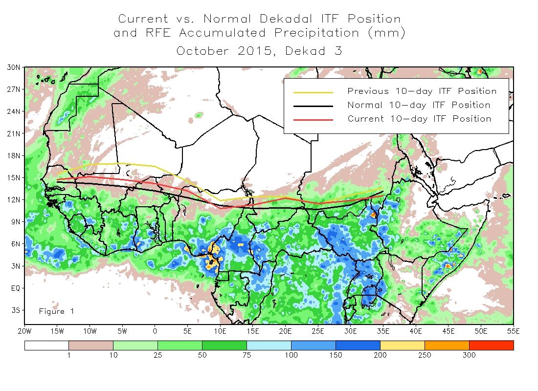
By the way is there any link that shows the ITCZ current position?
0 likes   

RL3AO
Moderator-Pro Met
Moderator-Pro Met
Posts: 16308
Joined: Thu Jun 14, 2007 10:03 pm
Location: NC

Re:

#6 Postby RL3AO » Tue May 06, 2008 1:12 pm

KWT wrote:By the way is there any link that shows the ITCZ current position?


Image
0 likes   

User avatar
HURAKAN
Professional-Met
Professional-Met
Posts: 46086
Age: 38
Joined: Thu May 20, 2004 4:34 pm
Location: Key West, FL
Contact:

#7 Postby HURAKAN » Tue May 06, 2008 1:13 pm

Image

This shot looks excellent!!! I just wish it was the hurricane season.
0 likes   

User avatar
KWT
Category 5
Category 5
Posts: 31415
Joined: Tue Aug 17, 2004 11:02 am
Location: UK!!!

#8 Postby KWT » Tue May 06, 2008 1:17 pm

thats a great image there, decent convection present!

Also interesting to see just how far south the ITCZ, also interesting to see that atlantic wave that came off Africa last week, wonder if that will do anything in the Pacific...
0 likes   

User avatar
cycloneye
Admin
Admin
Posts: 145923
Age: 69
Joined: Thu Oct 10, 2002 10:54 am
Location: San Juan, Puerto Rico

Re: Nice blob of convection on East Atlantic

#9 Postby cycloneye » Tue May 06, 2008 1:18 pm

ITCZ inside Africa as it normally does this time of the year is climbing in latitud.The red line.

Image
0 likes   

Ed Mahmoud

Re: Nice blob of convection on East Atlantic

#10 Postby Ed Mahmoud » Tue May 06, 2008 1:24 pm

Maybe this'll be the "A" storm when it reaches the East Pac.
0 likes   

User avatar
KWT
Category 5
Category 5
Posts: 31415
Joined: Tue Aug 17, 2004 11:02 am
Location: UK!!!

#11 Postby KWT » Tue May 06, 2008 1:25 pm

Won't be long therefore before we start to see an increase in the dust levels being dragged into the Atlantic on the ITCZ then cycloneye.

Still its at least another month and a half before we can realistically say we have to watch out for such systems, for example we did see a TD form in 2000 in late June.
0 likes   

User avatar
HURAKAN
Professional-Met
Professional-Met
Posts: 46086
Age: 38
Joined: Thu May 20, 2004 4:34 pm
Location: Key West, FL
Contact:

#12 Postby HURAKAN » Tue May 06, 2008 6:14 pm

Image

Image
0 likes   

StormspinnerD2

#13 Postby StormspinnerD2 » Tue May 06, 2008 6:18 pm

I think this is far too low in latitude to develop (it's south of 5N); it's just ITCZ anyway. The Atlantic is still fairly hostile for development this early on.
Last edited by StormspinnerD2 on Tue May 06, 2008 6:18 pm, edited 1 time in total.
0 likes   

Cyclone1
Category 5
Category 5
Posts: 2739
Age: 33
Joined: Tue Jun 12, 2007 12:03 pm
Location: Florida

#14 Postby Cyclone1 » Tue May 06, 2008 6:18 pm

Err... wow.

Already picking up.
0 likes   

User avatar
HURAKAN
Professional-Met
Professional-Met
Posts: 46086
Age: 38
Joined: Thu May 20, 2004 4:34 pm
Location: Key West, FL
Contact:

#15 Postby HURAKAN » Tue May 06, 2008 6:20 pm

I think no one believes it will develop, although it may do so in the EPAC, but it looks very interesting for the month of May.
0 likes   

User avatar
cycloneye
Admin
Admin
Posts: 145923
Age: 69
Joined: Thu Oct 10, 2002 10:54 am
Location: San Juan, Puerto Rico

Re: Nice blob of convection on East Atlantic

#16 Postby cycloneye » Fri May 09, 2008 7:47 pm

8:05 PM EDT Discussion:

BASED ON 1800 UTC SURFACE ANALYSIS AND SATELLITE IMAGERY THROUGH
2315 UTC.

...TROPICAL WAVES...
TROPICAL WAVE IS ALONG 37/38W S OF 8N MOVING W AT 15 KT. LATESTS
VIS SAT IMAGERY FOR THE DAY REVEALED WEAK CYCLONIC TURNING ALONG
THE WAVE AXIS NEAR 6N WHERE THERE ARE SOME SHOWER/TSTM ACTIVITY.
THE MIMIC-TPW PRODUCT FROM CIMSS ALSO SHOWS THE PRESENCE OF THIS
WAVE WITH A PRONOUNCED BULGE OF MOISTURE ON EITHER SIDE OF THE
WAVE AXIS. ACCORDING TO THE COMPUTER MODELS...THIS TROPICAL WAVE
WILL ENTER THE CARIBBEAN SEA ON TUE.


http://www.storm2k.org/weather/hw3.php? ... hwvmetric=

I want this wave to reach the Eastern Caribbean to clean what we have now here and that is plenty of dust.
0 likes   

User avatar
Recurve
Category 5
Category 5
Posts: 1640
Joined: Tue Aug 16, 2005 8:59 pm
Location: St. Petersburg, FL

Re: Nice blob of convection on East Atlantic

#17 Postby Recurve » Sat May 10, 2008 10:54 am

That was some fairly strong looking convection. Did anything survive? I don't have a good west Atlantic sat image.
0 likes   

StormspinnerD2

Re: Nice blob of convection on East Atlantic

#18 Postby StormspinnerD2 » Sat May 10, 2008 10:59 am

Image

No. It's hard for convection to survive when there's a jet not far north of 10N.
0 likes   

MiamiensisWx

Re: Nice blob of convection on East Atlantic

#19 Postby MiamiensisWx » Sat May 10, 2008 2:28 pm

StormspinnerD2 wrote:No. It's hard for convection to survive when there's a jet not far north of 10N.

Actually, the divergence often enhances convection, especially in the case of an easterly wave or broad open surface trough. The convection eventually decreases when the shear diminishes.

Nothing unusual...
0 likes   

User avatar
Category 5
Category 5
Category 5
Posts: 10074
Age: 35
Joined: Sun Feb 11, 2007 10:00 pm
Location: New Brunswick, NJ
Contact:

Re: Nice blob of convection on East Atlantic

#20 Postby Category 5 » Sat May 10, 2008 7:50 pm

Going poof in 5, 4, 3, 2, 1.....
0 likes   


Return to “Talkin' Tropics”

Who is online

Users browsing this forum: Cdenton12, Ian2401, Stratton23, tolakram and 63 guests