EPAC - blob watching

This is the general tropical discussion area. Anyone can take their shot at predicting a storms path.

Moderator: S2k Moderators

Forum rules

The posts in this forum are NOT official forecasts and should not be used as such. They are just the opinion of the poster and may or may not be backed by sound meteorological data. They are NOT endorsed by any professional institution or STORM2K. For official information, please refer to products from the National Hurricane Center and National Weather Service.

Help Support Storm2K
Message
Author
tolakram
Admin
Admin
Posts: 20020
Age: 62
Joined: Sun Aug 27, 2006 8:23 pm
Location: Florence, KY (name is Mark)

EPAC - blob watching

#1 Postby tolakram » Tue May 06, 2008 11:50 am

from:

http://www.nhc.noaa.gov/text/refresh/MI ... 1558.shtml?

E OF 110W...
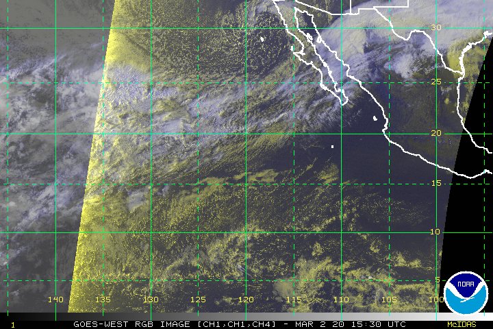
A DOMINANT MID- TO UPPER-LEVEL RIDGE STRETCHES FROM THE WESTERN
CARIBBEAN THROUGH CENTRAL MEXICO...WITH ITS AXIS SPREADING JUST
BEYOND W OF 110W. UNDERNEATH THE WESTERN SIDE OF THE RIDGE
ALOFT...SCATTERED CONVECTIVE ELEMENTS CONTINUE TO SHIFT WESTWARD
ALONG OR N OF THE ITCZ BETWEEN 100W AND 110W. THIS SYSTEM
APPEARED BETTER-ORGANIZED SUN AND MON...EXHIBITING SOME SIGNS
THAT SLOW TROPICAL CYCLONE DEVELOPMENT MIGHT HAVE BEEN
OCCURRING.
HOWEVER...SINCE THAT TIME...AN INCREASING WESTERLY
FLOW ALOFT AND PERHAPS OTHER FACTORS HAVE RESULTED IN NOTHING
MORE THAN A CHAOTIC CONVECTIVE PATTERN.

ELSEWHERE...WINDS GENERALLY REMAIN LIGHT ACROSS THE
REGION...EXCEPT DOWNWIND OF THE GULF OF PAPAGAYO WHERE NE TO E
20 KT WINDS HAVE BEEN BLOWING FROM OVERNIGHT INTO THIS MORNING.
SEAS GENERALLY RANGE FROM 5 TO 7 FT OFFSHORE THE MEXICAN AND
CENTRAL AMERICAN COASTS INTO THE OPEN TROPICAL EASTERN PACIFIC
IN A CONTINUATION OF THE LONG PERIOD SW SWELL PROPAGATING OUT OF
THE SOUTHERN HEMISPHERE EXTRATROPICS. SEAS IN VICINITY OF THE
GULF OF PAPAGAYO COULD BE LOCALLY UP TO 8 FT...HOWEVER. GOING
FORWARD...NO AREAS MEETING HIGH WIND CRITERIA OR WITH SEAS
GREATER THAN 8 FT ARE ANTICIPATED THROUGH AT LEAST MID-WEEK.


$$
KIMBERLAIN

Is this the first might have of the season? :)
Last edited by tolakram on Thu May 08, 2008 8:30 am, edited 1 time in total.
0 likes   

RL3AO
Moderator-Pro Met
Moderator-Pro Met
Posts: 16308
Joined: Thu Jun 14, 2007 10:03 pm
Location: NC

#2 Postby RL3AO » Tue May 06, 2008 11:58 am

"Might have been"? :D
0 likes   

User avatar
KWT
Category 5
Category 5
Posts: 31415
Joined: Tue Aug 17, 2004 11:02 am
Location: UK!!!

#3 Postby KWT » Tue May 06, 2008 12:21 pm

I've not heard that before being used but its interesting there was a good deal of convection in that region during the weekend days, yet another sign guys that the tropics in the N.Hemisphere are hotting up...
0 likes   

tolakram
Admin
Admin
Posts: 20020
Age: 62
Joined: Sun Aug 27, 2006 8:23 pm
Location: Florence, KY (name is Mark)

Re: EPAC - 100W - 110W

#4 Postby tolakram » Tue May 06, 2008 12:27 pm

I think the area between 115 and 120, 125 looks interesting:

Image

Too far south I believe, but intense. Shear is upwards of 30+ knots.
Last edited by tolakram on Tue May 06, 2008 12:30 pm, edited 1 time in total.
0 likes   

User avatar
cycloneye
Admin
Admin
Posts: 145922
Age: 69
Joined: Thu Oct 10, 2002 10:54 am
Location: San Juan, Puerto Rico

Re: EPAC - 100W - 110W

#5 Postby cycloneye » Tue May 06, 2008 12:28 pm

Image
0 likes   

User avatar
KWT
Category 5
Category 5
Posts: 31415
Joined: Tue Aug 17, 2004 11:02 am
Location: UK!!!

#6 Postby KWT » Tue May 06, 2008 12:34 pm

Yeah the convection isn't bad but I agree there probably is a little too much shear, esp north of 10N from the looks of things.
0 likes   

User avatar
masaji79
Tropical Storm
Tropical Storm
Posts: 183
Joined: Sun Dec 02, 2007 12:36 am
Location: Las Vegas, Nevada

Re: EPAC - 100W - 110W

#7 Postby masaji79 » Tue May 06, 2008 1:33 pm

Hopefully this doesn't mean that the Eastern Pacific will be really busy this year. I don't want my vacation to Hawaii be like last year when Flossie was brushed past. 8-)
0 likes   

User avatar
KWT
Category 5
Category 5
Posts: 31415
Joined: Tue Aug 17, 2004 11:02 am
Location: UK!!!

#8 Postby KWT » Tue May 06, 2008 1:38 pm

Well to be honest I'm pretty sure its perfectly normal for the Pacific ITCZ to really get going at this time of year, given the offical start of the EPAC season is on the 15th of May.

will be interesting to see if this season is busier then recent seasons.
0 likes   

User avatar
Chacor
Category 5
Category 5
Posts: 10229
Joined: Mon Oct 02, 2006 10:43 pm
Location: Singapore

#9 Postby Chacor » Tue May 06, 2008 9:48 pm

If anything, a more active EPac season tends to mean a less active Atlantic season.
0 likes   

tolakram
Admin
Admin
Posts: 20020
Age: 62
Joined: Sun Aug 27, 2006 8:23 pm
Location: Florence, KY (name is Mark)

Re: EPAC - 100W - 110W

#10 Postby tolakram » Wed May 07, 2008 10:00 am

from: http://www.nhc.noaa.gov/text/refresh/MI ... 1003.shtml?

WHILE THE ITCZ IS CONVECTIVELY ACTIVE FROM 106W TO 121W...NO
SIGNIFICANT TROPICAL DISTURBANCES ARE CURRENTLY INDICATED TO BE
ASSOCIATED THE CONVECTION. NONE OF THE GLOBAL MODELS SUGGEST
TROPICAL CYCLOGENESIS MAY OCCUR IN THE NEXT FEW DAYS. THIS MAY
BE DUE TO TOO MUCH WESTERLY WIND SHEAR AS WELL AS INSUFFICIENT
LOW LEVEL VORTICITY.
0 likes   

User avatar
KWT
Category 5
Category 5
Posts: 31415
Joined: Tue Aug 17, 2004 11:02 am
Location: UK!!!

#11 Postby KWT » Wed May 07, 2008 11:18 am

Yeah generally thats true if the EPAC is active then the Atlantic will be less so. Anyway plenty of convection about still but nothing that could develop any time soon from the looks of things.
0 likes   

tolakram
Admin
Admin
Posts: 20020
Age: 62
Joined: Sun Aug 27, 2006 8:23 pm
Location: Florence, KY (name is Mark)

Re: EPAC - 100W - 110W

#12 Postby tolakram » Thu May 08, 2008 8:29 am

http://www.nhc.noaa.gov/text/refresh/MI ... 0958.shtml?

A SURFACE TROUGH HAS DEVELOPED ALONG THE ITCZ NEAR 108W.
SCATTERED MODERATE TO STRONG CONVECTION IS OCCURRING WITHIN 90
NM OF 12N108W IN ASSOCIATION WITH THE DISTURBANCE. MOST OF THE
GLOBAL MODELS HOLD ON TO THE TROUGH FOR THE NEXT FEW DAYS AND
MOVE IT SLOWLY WESTWARD WITHOUT SIGNIFICANT DEVELOPMENT.
RELATIVELY SMALL AMOUNTS OF VORTICITY ON THE SYNOPTIC SCALE AND
A SOMEWHAT STABLE ENVIRONMENT LIKELY ARE THE REASONS FOR THE
LACK OF INTEREST IN THE MODELS FOR FURTHER DEVELOPMENT.

Image

Image
0 likes   

Ed Mahmoud

Re:

#13 Postby Ed Mahmoud » Thu May 08, 2008 8:35 am

KWT wrote:Yeah generally thats true if the EPAC is active then the Atlantic will be less so. Anyway plenty of convection about still but nothing that could develop any time soon from the looks of things.


Well, in the case of El Niño, the chicken vs egg argument is pretty clear, but other than that, an active Pacific season might be because of a slow Atlantic season, in that the African waves aren't developing and then eventually recurving in the Atlantic. So more waves make it into the EPac.


Just an uneducated theory.
0 likes   

tolakram
Admin
Admin
Posts: 20020
Age: 62
Joined: Sun Aug 27, 2006 8:23 pm
Location: Florence, KY (name is Mark)

Re: EPAC - blob watching

#14 Postby tolakram » Thu May 08, 2008 9:06 am

0 likes   

User avatar
HURAKAN
Professional-Met
Professional-Met
Posts: 46086
Age: 38
Joined: Thu May 20, 2004 4:34 pm
Location: Key West, FL
Contact:

#15 Postby HURAKAN » Thu May 08, 2008 10:46 am

Image

Nothing expected at the moment but not a bad show from the EPAC.
0 likes   

User avatar
KWT
Category 5
Category 5
Posts: 31415
Joined: Tue Aug 17, 2004 11:02 am
Location: UK!!!

#16 Postby KWT » Thu May 08, 2008 11:30 am

Yep still some decent convection about though your right nothing cis expected to come of it, just looks nice!
0 likes   

tolakram
Admin
Admin
Posts: 20020
Age: 62
Joined: Sun Aug 27, 2006 8:23 pm
Location: Florence, KY (name is Mark)

Re: EPAC - blob watching

#17 Postby tolakram » Thu May 08, 2008 2:48 pm

...

FINALLY...SATELLITE IMAGERY SHOWS AN INCREASE IN MOSTLY
DISORGANIZED CONVECTIVE ACTIVITY IN THE VICINITY OF 10N110W...
LIKELY IN ASSOCIATION WITH A WEAK LOW-LEVEL CYCLONIC CIRCULATION
ALONG THE ITCZ NEAR 9N107W. THE LOCATION OF THIS SYSTEM SUGGESTS
THAT THIS IS THE SAME CONVECTIVE CLUSTER WHICH HAS TRACKED S OF
10N W OF 95W THE LAST FEW DAYS. ALTHOUGH WATER VAPOR IMAGERY
AND CIMMS CLOUD-TRACKED WINDS CURRENTLY SHOW A DIFFLUENT
UPPER-LEVEL FLOW OVER THE SYSTEM...A CURRENT OF STRONG WESTERLY
FLOW LIES JUST TO THE W AND WILL LIKELY LIMIT ANY POSSIBLE
DEVELOPMENT.

$$
KIMBERLAIN

http://www.nhc.noaa.gov/text/refresh/MI ... 1542.shtml?
0 likes   

RL3AO
Moderator-Pro Met
Moderator-Pro Met
Posts: 16308
Joined: Thu Jun 14, 2007 10:03 pm
Location: NC

#18 Postby RL3AO » Thu May 08, 2008 10:48 pm

Image
0 likes   

RL3AO
Moderator-Pro Met
Moderator-Pro Met
Posts: 16308
Joined: Thu Jun 14, 2007 10:03 pm
Location: NC

#19 Postby RL3AO » Thu May 08, 2008 10:51 pm

Kinda interesting.

Image
0 likes   

tolakram
Admin
Admin
Posts: 20020
Age: 62
Joined: Sun Aug 27, 2006 8:23 pm
Location: Florence, KY (name is Mark)

Re: EPAC - blob watching

#20 Postby tolakram » Fri May 09, 2008 8:24 am

http://www.nhc.noaa.gov/text/refresh/MI ... 0958.shtml?

...
THE TROPICAL DISTURBANCE NEAR 110W HAS DEVELOPED A WEAK 1010 MB
LOW PRESSURE CENTER AS SEEN FROM TAO BUOYS...SCATTEROMETER
DATA...AND LOW-LEVEL CLOUD MOTIONS. CONVECTION ASSOCIATED WITH
THE SYSTEM HAS SHOWN DIURNAL PULSES THAT ADVECT NORTHWARD AWAY
FROM THE SURFACE CENTER. CONTINUED MODERATE SOUTHERLY VERTICAL
SHEAR SHOULD PRECLUDE FURTHER DEVELOPMENT.

THE EARLIER ANALYZED GAP WINDS IN THE GULF OF PAPAGAYO REGION
HAVE DIMINISHED TO JUST BELOW 20 KT...ACCORDING TO OBSERVATIONS
FROM BOTH QUIKSCAT AND ASCAT.

$$
LANDSEA

Image
0 likes   


Return to “Talkin' Tropics”

Who is online

Users browsing this forum: gib and 53 guests