Thoughts on 2013 Atlantic Hurricane Season

This is the general tropical discussion area. Anyone can take their shot at predicting a storms path.

Moderator: S2k Moderators

Forum rules

The posts in this forum are NOT official forecasts and should not be used as such. They are just the opinion of the poster and may or may not be backed by sound meteorological data. They are NOT endorsed by any professional institution or STORM2K. For official information, please refer to products from the National Hurricane Center and National Weather Service.

Help Support Storm2K
Message
Author
User avatar
Extratropical94
Professional-Met
Professional-Met
Posts: 3538
Age: 30
Joined: Wed Oct 20, 2010 6:36 am
Location: Hamburg, Germany
Contact:

Re: Thoughts on activity as heart of season has passed

#961 Postby Extratropical94 » Thu Sep 19, 2013 2:06 pm

supercane4867 wrote:The Atlantic is died.


Western Pacific is taking over right now and that basin might still be favorable in December... who knows.
Has been much more interesting to watch this year...
0 likes   
54° 11' 59'' N, 9° 9' 20'' E
Boomer Sooner!
Go Broncos! Go Cards! Go Niners!
- Daniel

User avatar
wxman57
Moderator-Pro Met
Moderator-Pro Met
Posts: 22978
Age: 67
Joined: Sat Jun 21, 2003 8:06 pm
Location: Houston, TX (southwest)

Re:

#962 Postby wxman57 » Thu Sep 19, 2013 2:07 pm

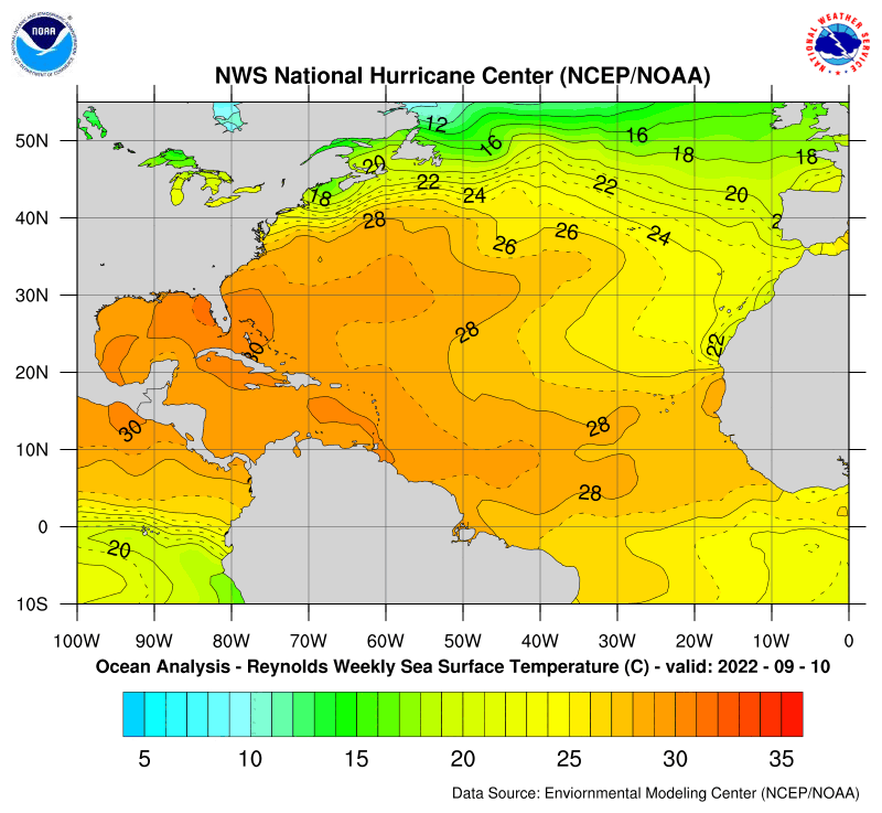
CrazyC83 wrote:That red could fuel Humberto in the next couple days - possibly as a post-tropical storm though


Remember, that graphic only represents temps compared to normal. Quite warm water in the deep tropics. Humberto's remnants are moving over cooler and cooler water to the north. Oh, and its LLC dissipated. Last advisory should be issued soon.

Image
0 likes   

supercane4867
Category 5
Category 5
Posts: 4966
Joined: Wed Nov 14, 2012 10:43 am

Re: Thoughts on activity as heart of season has passed

#963 Postby supercane4867 » Thu Sep 19, 2013 2:21 pm

Extratropical94 wrote:
supercane4867 wrote:The Atlantic is died.


Western Pacific is taking over right now and that basin might still be favorable in December... who knows.
Has been much more interesting to watch this year...

This is how WPAC usually behaves...nothing above normal there
While WPAC is active the EPAC tends to act the same, but now it just being dominate by dry air :roll:
0 likes   

CYCLONE MIKE
Category 5
Category 5
Posts: 2183
Joined: Tue Aug 31, 2004 6:04 pm
Location: Gonzales, LA

Re: Thoughts on activity as heart of season has passed

#964 Postby CYCLONE MIKE » Thu Sep 19, 2013 4:15 pm

Winter can't get here soon enough. Even for the deep south it has got to be more interesting than this hurricane season, or lack thereof :lol:
0 likes   

WeatherGuesser
Category 5
Category 5
Posts: 2672
Joined: Tue Jun 29, 2010 6:46 am

#965 Postby WeatherGuesser » Thu Sep 19, 2013 4:21 pm

Not sure why Mexico has been taking it on the chin so bad this year. Even without major storms, they've had more than enough.
0 likes   

User avatar
chaser1
S2K Supporter
S2K Supporter
Posts: 5464
Age: 64
Joined: Sat Oct 15, 2005 5:59 pm
Location: Longwood, Fl

Re: Thoughts on activity as heart of season has passed

#966 Postby chaser1 » Thu Sep 19, 2013 7:30 pm

CYCLONE MIKE wrote:Winter can't get here soon enough. Even for the deep south it has got to be more interesting than this hurricane season, or lack thereof :lol:


DITTO!
0 likes   
Andy D

(For official information, please refer to the NHC and NWS products.)

User avatar
NDG
S2K Supporter
S2K Supporter
Posts: 15446
Joined: Sun Jul 09, 2006 10:14 pm
Location: Orlando, FL

Re: Thoughts on activity as heart of season has passed

#967 Postby NDG » Thu Sep 19, 2013 7:51 pm

The Mayans were right after all ;)

The question prior to the peak of the season was: is activity going to pick up in the tropics, now that the peak of the season passed, with only 2 weak hurricanes that came out of it now the question is will the rest of the season produce a Cat 3 hurricane?
I say that chances are very, very low, IMO, going with the trend.
0 likes   

psyclone
S2K Supporter
S2K Supporter
Posts: 4762
Joined: Wed Aug 24, 2005 9:04 pm
Location: palm harbor fl

#968 Postby psyclone » Thu Sep 19, 2013 9:28 pm

I'm bored. this really is turning into the season that wasn't. we still have October which can be a big month but it's not uncommon for October to be dead too. it's tough to bet against persistence this year, especially now that average activity on a rapid downward slope. still, I will continue to keep a wary eye to the south until Halloween as I do every year.
0 likes   

dexterlabio
Category 5
Category 5
Posts: 3468
Joined: Sat Oct 24, 2009 11:50 pm

Re: Thoughts on activity as heart of season has passed

#969 Postby dexterlabio » Thu Sep 19, 2013 10:34 pm

maybe you'll have to wait until Halloween? You'll never know, a Halloween surprise like Sandy might get you. I think it is possible that TC genesis will be favored by the second half of October. Given that the strong MJO pulse is now in the border of WPAC and Maritime Continent, it could take some weeks to travel across the Pacific and reach the Caribbean. That would be the last chance for at least one significant hurricane to develop IMO.
0 likes   
Personal Forecast Disclaimer:
The posts in this forum are NOT official forecast and should not be used as such. They are just the opinion of the poster and may or may not be backed by sound meteorological data. They are NOT endorsed by any professional institution or storm2k.org. For official information, please refer to the NHC and NWS products.

User avatar
Hammy
Category 5
Category 5
Posts: 5849
Age: 41
Joined: Fri May 25, 2012 5:25 pm
Contact:

#970 Postby Hammy » Fri Sep 20, 2013 3:09 pm

While I don't wish for any strong system impacting the coast, that everything this year struggles is becoming quite agitating, and at this point I don't see the season ramping up at all as its almost 2/3 over, and the models show zilch for the rest of the month. We may see 2-3 weak more storms for the remainder of the season, tops.
0 likes   
The above post is not official and should not be used as such. It is the opinion of the poster and may or may not be backed by sound meteorological data. It is not endorsed by any professional institution or storm2k.org. For official information, please refer to the NHC and NWS products.

WeatherGuesser
Category 5
Category 5
Posts: 2672
Joined: Tue Jun 29, 2010 6:46 am

#971 Postby WeatherGuesser » Fri Sep 20, 2013 3:21 pm

I'm in for a late surprise somewhere.
0 likes   

User avatar
ROCK
Category 5
Category 5
Posts: 9484
Age: 54
Joined: Tue Aug 17, 2004 7:30 am
Location: Kemah, Texas

Re:

#972 Postby ROCK » Fri Sep 20, 2013 4:29 pm

Hammy wrote:While I don't wish for any strong system impacting the coast, that everything this year struggles is becoming quite agitating, and at this point I don't see the season ramping up at all as its almost 2/3 over, and the models show zilch for the rest of the month. We may see 2-3 weak more storms for the remainder of the season, tops.


what do you exepct the models to show? 3 cat5's spinning around the ATL? :wink: and the models show more than zilch. the EURO is hinting at a TS in the med range now...wont impact the CONUS but it is something.
0 likes   

CYCLONE MIKE
Category 5
Category 5
Posts: 2183
Joined: Tue Aug 31, 2004 6:04 pm
Location: Gonzales, LA

Re: Thoughts on activity as heart of season has passed

#973 Postby CYCLONE MIKE » Fri Sep 20, 2013 4:32 pm

In my opinion its about all but over, well actually has been for a while now. 95 l was the gulfs last chance to breed something and has failed yet again. Models show nothing rest if the month. October should see even more hostile conditions around here. Bring on our winter watching southern snow storms :P
0 likes   
This post is NOT AN OFFICIAL FORECAST and should not be used as such. It is just the opinion of the poster and may or may not be backed by sound meteorological data. It is NOT endorsed by any professional institution including storm2k.org. For Official Information please refer to the NHC and NWS products.

User avatar
MetroMike
Category 4
Category 4
Posts: 952
Joined: Sun Aug 29, 2004 8:13 pm
Location: Tampa Bay
Contact:

Re: Thoughts on activity as heart of season has passed

#974 Postby MetroMike » Fri Sep 20, 2013 4:51 pm

Yes I agree Cyclone Mike....seems the trend is our friend this year. Don't think that all the so-called teleconnections with the WPAC. will work like they are supposed to with the ATL. basin this year. Just like they say out west " when in a drought don't predict rain." Same holds true with our basin.

As my avatar shows i'm ready for this season to pass.
0 likes   

User avatar
weatherwindow
Category 4
Category 4
Posts: 904
Joined: Mon Sep 20, 2004 9:48 am
Location: key west/ft lauderdale

Re:

#975 Postby weatherwindow » Fri Sep 20, 2013 7:25 pm

gatorcane wrote:Past the peak by over a week now and here is our current map for this year. Who would have thought it would have been this lackluster to date?

Image


http://www.weatheronline.co.uk/cgi-bin/ ... RES=0&WMO=

Good evening, Chris....That track map is rather startling, isnt it. Has the look of one of the -AMO, pre-satellite seasons. Just when we thought we had a reasonable grasp of seasonal genesis and development, a season like 2013 comes by and provides a strong dose of humility. Climo would certainly dictate an imminent close to the Cape Verde season. Perhaps October will provide something of substance to hold our interest. Little of value is indicated in the latest run of CFSv2(Oct 5-Nov 3), save a general lowering of pressure in the western Caribbean and a few nebulous lows ejecting east and south of Florida in the absence of any persistent ridging over the western Atlantic. Given the obvious lack of forecast values in long-term modelling, perhaps we can retain a bit of optimism in the ultimate outcome of the remainder of a surprisingly quiet 2013...Grtz from KW, Rich
0 likes   

CYCLONE MIKE
Category 5
Category 5
Posts: 2183
Joined: Tue Aug 31, 2004 6:04 pm
Location: Gonzales, LA

Re: Thoughts on activity as heart of season has passed

#976 Postby CYCLONE MIKE » Fri Sep 20, 2013 8:04 pm

Don't know if it was an el nino or whatever, doesn't really make a difference, but this year really looks like 1993. I can't post the pic but maybe gatorcane or somebody else would be nice enough to. Who would have thought with all the early season doom and gloom forecasts it would look like this.
0 likes   

USTropics
Professional-Met
Professional-Met
Posts: 2650
Joined: Sun Aug 12, 2007 3:45 am
Location: Florida State University

Re: Thoughts on activity as heart of season has passed

#977 Postby USTropics » Fri Sep 20, 2013 9:48 pm

CYCLONE MIKE wrote:Don't know if it was an el nino or whatever, doesn't really make a difference, but this year really looks like 1993. I can't post the pic but maybe gatorcane or somebody else would be nice enough to. Who would have thought with all the early season doom and gloom forecasts it would look like this.


Code: Select all

ENSO                                             
Type   Season       JJA   JAS   ASO   SON   OND   NDJ   DJF   JFM   FMA   MAM   AMJ   MJJ

    1992   -   1993   0.3   0.0   -0.2   -0.3   -0.2   0.0   0.2   0.3   0.5   0.6   0.6   0.5
    1993   -   1994   0.3   0.2   0.2   0.2   0.1   0.1   0.1   0.1   0.2   0.3   0.4   0.4
   1994   -   1995   0.4   0.4   0.5   0.7   1.0   1.2   1.0   0.8   0.6   0.3   0.2   0.0


Image

Most of the activity was in August/September followed by 2 months of nothing:

Image
0 likes   

CYCLONE MIKE
Category 5
Category 5
Posts: 2183
Joined: Tue Aug 31, 2004 6:04 pm
Location: Gonzales, LA

Re: Thoughts on activity as heart of season has passed

#978 Postby CYCLONE MIKE » Fri Sep 20, 2013 10:12 pm

Thanks UStropic. If somebody would have said this season would look like that, they would of been laughed right off this forum.
0 likes   

User avatar
Andrew92
S2K Supporter
S2K Supporter
Posts: 3247
Age: 41
Joined: Mon Jun 16, 2003 12:35 am
Location: Phoenix, Arizona

#979 Postby Andrew92 » Sat Sep 21, 2013 1:06 am

The following post is NOT an official forecast and should not be used as such. It is just the opinion of the poster and may or may not be backed by sound meteorological data. It is NOT endorsed by any professional institution or storm2k.org. For official information, please refer to the NHC and NWS products.

This isn't an El Nino, as sea surface temperature anomalies in the equatorial Pacific are cooler than normal if anything. However, I have another one of my (in)famous statistical analyses for why I think 2013 has been less active from an El Nino perspective.

I have however noticed one thing when there is a long drought between traditional El Nino episodes. I have gone over and over about how the second hurricane season after the episode subsides that a major hurricane usually hits the US somewhere. However, what happens after such year passes with no El Nino? Well I'm not really sure why this is, but seasons turn a little less quiet until the next El Nino passes. What's more, between that second year after an El Nino and the next one, the US tends to be spared big storms. In fact, there have been eight hurricane seasons in the satellite era that have fit this bill, between a second year after El Nino, and before the next one. Only three of them featured any hurricanes hit the US at all. One of them was 1971 which featured three, but all of them were barely hurricanes upon reaching the coast. The others are 1961 and 1975. All of the other five years - 1962, 1981, 1990, 2000, and 2001 - did not see a single hurricane reach the US. I mentioned in another topic that 2012 may have been what I am dubbing as an "accelerated" El Nino, where water temperatures in the equatorial Pacific spiked early on, only to cool down rapidly before the heart of the season, perhaps making things favorable for a big storm like Sandy to reach the US.

I have to study a little more about what went on in 1961, but I have come up with a theory on why a major hurricane was able to reach the coast in 1975 going on my whole El Nino thing. I won't mention it in this post for a couple of reasons: first it gets to be going off of this main topic, and second the theory I have involves a very miniscule sample size that should be taken with a huge grain of salt. I will say this for 2013, that it does not meet the same criteria I have in mind for 1975.

Wow, I've gone off a quite a lot. However, it does all have a point to this year. This is a year that is before our next El Nino, and after the favorable year for the US to take a serious hurricane hit. On top of it, as mentioned, those types of hurricane seasons often see fewer quality storms. Many times in these years, we reach double digits for named storms, but so many are short-lived and weak with only a few becoming really decent hurricanes, if any. Some say that 1990, 2000, and 2001 are more active seasons, and would be partially correct. However, only one storm out of 14 in 1990 became a major hurricane briefly, and the MDR storms in 2000 and 2001 by and large weakened as they went west and only really got going north of the Tropic of Cancer. Some have mentioned that El Nino is needed to moisten the air. I am unsure of this but it would not entirely surprise me either as in some of the more recent hurricane seasons I notice the EPAC is also quiet from a quality perspective too. 1981 saw 15 storms form in that basin but only one became a major; 2000 featured 17 storms in the EPAC but only six became hurricanes of any type; 2001 had 15 storms with only two becoming majors. As such, the EPAC has also seen less than stellar activity this year either, with 13 storms so far and no majors.

In short, we all know that El Nino does make for a brief quiet spell in the Atlantic in terms of tropical activity. But without this phenomenon every so often, energy for these storms to sustain probably just runs out in both the Atlantic and the EPAC. With no El Nino currently in place, I am conjecturing that is what is going on this year, and it may take an El Nino to bring back the energy needed for storms to form in these two basins later on down the road.

-Andrew92
0 likes   

User avatar
TropicalAnalystwx13
Category 5
Category 5
Posts: 2109
Age: 27
Joined: Tue Jul 19, 2011 8:20 pm
Location: Wilmington, NC
Contact:

#980 Postby TropicalAnalystwx13 » Sat Sep 21, 2013 12:46 pm

:uarrow: We have to keep in mind that 1961, 1971, and 1975 were all during the negative AMO period. Cold sea surface temperatures leads to less and weaker tropical cyclones.
0 likes   


Return to “Talkin' Tropics”

Who is online

Users browsing this forum: Cpv17, Stormybajan, Teban54, Ulf and 39 guests