Low pressure developing over the western Caribbean Sea (Is Invest 97L)

This is the general tropical discussion area. Anyone can take their shot at predicting a storms path.

Moderator: S2k Moderators

Forum rules

The posts in this forum are NOT official forecasts and should not be used as such. They are just the opinion of the poster and may or may not be backed by sound meteorological data. They are NOT endorsed by any professional institution or STORM2K. For official information, please refer to products from the National Hurricane Center and National Weather Service.

Help Support Storm2K
Message
Author
User avatar
StPeteMike
Category 2
Category 2
Posts: 631
Joined: Thu Jun 07, 2018 11:26 pm

Re: Area of low pressure to develop over the western Caribbean sea (0/60)

#941 Postby StPeteMike » Sat Sep 21, 2024 5:43 pm

Stormcenter wrote:GFS will probably have heading to Tampa on its next run.
I don’t trust it one bit.

Honestly though, think this set-up of between Pensacola and Port Charlotte is pretty accurate. No -removed- here, I just paid off my car! Last thing I need is a hurricane forcing back into car payments.
2 likes   
The above post is not official and should not be used as such. It is the opinion of the poster and may or may not be backed by sound meteorological data. It is not endorsed by any professional institution or storm2k.org. For official information, please refer to the NHC and NWS products.

caneman
Category 5
Category 5
Posts: 1447
Joined: Fri Sep 05, 2014 5:44 am
Location: Clearwater Beach, Fl

Re: Area of low pressure to develop over the western Caribbean sea (0/60)

#942 Postby caneman » Sat Sep 21, 2024 5:46 pm

wx98 wrote:
eastcoastFL wrote:
caneman wrote:
To each his own. I appreciate it.


I actually appreciate it as well.


The information is more easily found and understood by visiting an actual model page than trying to deduce what is being typed bit by bit, but okay….


Again, to each his own.
2 likes   

User avatar
robbielyn
Category 5
Category 5
Posts: 1298
Joined: Wed May 07, 2003 9:45 am
Location: brooksville, fl

Re: Area of low pressure to develop over the western Caribbean sea (0/60)

#943 Postby robbielyn » Sat Sep 21, 2024 5:47 pm

did anyone see the 977mb storm on the epac side of mexico at sept 27th frame 234?
Last edited by robbielyn on Sat Sep 21, 2024 5:54 pm, edited 1 time in total.
0 likes   
Robbielyn McCrary
I know just about enough to sound like I know what I'm talking about sometimes. But for your safety please follow the nhc for truly professional forecasting. :D

Ian2401
Category 1
Category 1
Posts: 307
Joined: Thu Sep 14, 2017 5:55 pm
Location: Tallahassee, Florida
Contact:

Re: Area of low pressure to develop over the western Caribbean sea (0/60)

#944 Postby Ian2401 » Sat Sep 21, 2024 5:49 pm

Image
genesis probs spiking on TCLOGG. up to 69%. NHC should go up to 70% at 8p
1 likes   
B.S. Meteorology from Florida State '24 // Current M.S. Meteorology student at Florida State

Research Interests: Rapid Intensification, TC Climatology, TC Modeling

Consult the NHC for official information

User avatar
gatorcane
S2K Supporter
S2K Supporter
Posts: 23691
Age: 47
Joined: Sun Mar 13, 2005 3:54 pm
Location: Boca Raton, FL

Re: Area of low pressure to develop over the western Caribbean sea (0/60)

#945 Postby gatorcane » Sat Sep 21, 2024 5:50 pm

The GEFS ensembles yet again look no bueno for the EGOM, Big Bend, and Tampa Bay area:

Image
4 likes   

psyclone
S2K Supporter
S2K Supporter
Posts: 4762
Joined: Wed Aug 24, 2005 9:04 pm
Location: palm harbor fl

Re: Area of low pressure to develop over the western Caribbean sea (0/60)

#946 Postby psyclone » Sat Sep 21, 2024 5:53 pm

I think much of Florida is going to get hosed at a minimum. I also suspect my (semi) tongue in cheek posts aboot Tampa Bay exemptions may come back to haunt me. Still lookin' for that elusive cold front
2 likes   

User avatar
StPeteMike
Category 2
Category 2
Posts: 631
Joined: Thu Jun 07, 2018 11:26 pm

Re: Area of low pressure to develop over the western Caribbean sea (0/60)

#947 Postby StPeteMike » Sat Sep 21, 2024 5:57 pm

Ian2401 wrote:https://moe.met.fsu.edu/modelgen/CON168AL_latest.png
genesis probs spiking on TCLOGG. up to 69%. NHC should go up to 70% at 8p

10%/70% sounds about right, wouldn’t be surprised to see 80-% though.
1 likes   
The above post is not official and should not be used as such. It is the opinion of the poster and may or may not be backed by sound meteorological data. It is not endorsed by any professional institution or storm2k.org. For official information, please refer to the NHC and NWS products.

User avatar
SFLcane
S2K Supporter
S2K Supporter
Posts: 10163
Age: 47
Joined: Sat Jun 05, 2010 1:44 pm
Location: Lake Worth Florida

Re: Area of low pressure to develop over the western Caribbean sea (0/60)

#948 Postby SFLcane » Sat Sep 21, 2024 6:01 pm

Being this is still 5-7 days from being a threat lots will change.
2 likes   

DunedinDave
Tropical Storm
Tropical Storm
Posts: 227
Joined: Fri Aug 25, 2023 10:31 am

Re: Area of low pressure to develop over the western Caribbean sea (0/60)

#949 Postby DunedinDave » Sat Sep 21, 2024 6:01 pm

I Still think Tampa Bay will escape a direct hit. Only way it won’t is if the center establishes itself further east than what they’re saying. But this has Debby and Idalia written all over it where the west coast gets hammered with rain and the center passes somewhere between Appalachicola to Cedar Key.
1 likes   

BobHarlem
Category 5
Category 5
Posts: 2105
Joined: Thu Oct 20, 2005 6:11 pm

Re: Area of low pressure to develop over the western Caribbean sea (0/60)

#950 Postby BobHarlem » Sat Sep 21, 2024 6:04 pm

Interesting setup on landfall on the 18z. Must be shear vector enhanced. It stays a hurricane all the way inland to Charlotte, NC on that run.
0 likes   

User avatar
Steve
S2K Supporter
S2K Supporter
Posts: 9621
Joined: Sat Apr 05, 2003 11:41 pm
Location: Not a state-caster

Re: Area of low pressure to develop over the western Caribbean sea (0/60)

#951 Postby Steve » Sat Sep 21, 2024 6:06 pm

Yeah chill on that criticism imho. If it were a classified entity there would be a models thread.

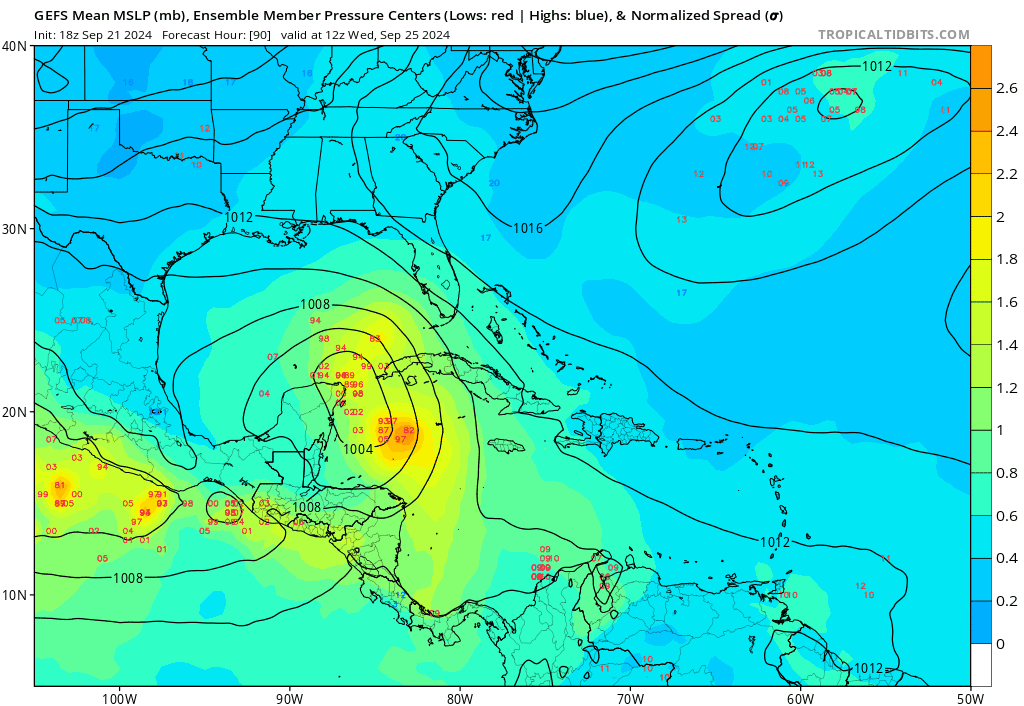
953 is fairly close to a Cat 3 which is notoriously tough past Apalacholicola on the Panhandle. it has happened on some rare occasions so it’s not out of the question entirely. But my bet would be slightly weaker if it took the GFS track. Definitely a dangerous outcome for Jacksonville, Thomasville, Valdosta and Savannah but if it comes in east of Carabelle and Sopchoppy perhaps Tally could be mostly spared H force winds with towns east like Madison, Monticello and Perry getting smacked. St. Marks is one of the last coastal towns that way and lots of estuaries are farther east. You’d expect surge issues in St. George, Alligator Point, Panacea and Bald Point. I haven’t been down that way in a few years, but people do live in those communities. Hope it is weaker if GFS is onto anything.
4 likes   

User avatar
Steve
S2K Supporter
S2K Supporter
Posts: 9621
Joined: Sat Apr 05, 2003 11:41 pm
Location: Not a state-caster

Re: Area of low pressure to develop over the western Caribbean sea (0/60)

#952 Postby Steve » Sat Sep 21, 2024 6:09 pm

Also end of that GFS run still wants a part 2 - this time at the Peninsula
3 likes   

User avatar
Ivanhater
Storm2k Moderator
Storm2k Moderator
Posts: 11161
Age: 38
Joined: Fri Jul 01, 2005 8:25 am
Location: Pensacola

Re: Area of low pressure to develop over the western Caribbean sea (0/60)

#953 Postby Ivanhater » Sat Sep 21, 2024 6:11 pm

GFS is still on the east side of guidance. We'll see what overnight models say. Biloxi to Apalachicola is the current model range
0 likes   
Michael

User avatar
Ivanhater
Storm2k Moderator
Storm2k Moderator
Posts: 11161
Age: 38
Joined: Fri Jul 01, 2005 8:25 am
Location: Pensacola

Re: Area of low pressure to develop over the western Caribbean sea (0/60)

#954 Postby Ivanhater » Sat Sep 21, 2024 6:11 pm

GFS is still on the east side of guidance. We'll see what overnight models say. Biloxi to Apalachicola is the current model range
0 likes   
Michael

DunedinDave
Tropical Storm
Tropical Storm
Posts: 227
Joined: Fri Aug 25, 2023 10:31 am

Re: Area of low pressure to develop over the western Caribbean sea (0/60)

#955 Postby DunedinDave » Sat Sep 21, 2024 6:11 pm

Steve wrote:Also end of that GFS run still wants a part 2 - this time at the Peninsula

They don’t call it happy hour for nothing.
1 likes   

User avatar
Blown Away
S2K Supporter
S2K Supporter
Posts: 10145
Joined: Wed May 26, 2004 6:17 am

Re: Area of low pressure to develop over the western Caribbean sea (0/60)

#956 Postby Blown Away » Sat Sep 21, 2024 6:20 pm

Image

ATM it appears the L would set up a little farther E.
7 likes   
Hurricane Eye Experience: David 79, Irene 99, Frances 04, Jeanne 04, Wilma 05... EYE COMING MY WAY IN 2024…
Hurricane Brush Experience: Andrew 92, Erin 95, Floyd 99, Matthew 16, Irma 17, Ian 22, Nicole 22…

User avatar
StPeteMike
Category 2
Category 2
Posts: 631
Joined: Thu Jun 07, 2018 11:26 pm

Re: Area of low pressure to develop over the western Caribbean sea (0/60)

#957 Postby StPeteMike » Sat Sep 21, 2024 6:28 pm

Blown Away wrote:[url]https://i.postimg.cc/0j2NTzD6/goes16-vis-swir-watl.gif [/url]

ATM it appears the L would set up a little farther E.

It would be crazy if this got itself together days before it’s expected to do so. I would wonder if it would just meander around the northwest Caribbean or move north sooner than expected as well.
1 likes   
The above post is not official and should not be used as such. It is the opinion of the poster and may or may not be backed by sound meteorological data. It is not endorsed by any professional institution or storm2k.org. For official information, please refer to the NHC and NWS products.

User avatar
boca
Category 5
Category 5
Posts: 6367
Age: 60
Joined: Mon Dec 15, 2003 8:49 am
Location: Boca Raton,FL

Re: Area of low pressure to develop over the western Caribbean sea (0/60)

#958 Postby boca » Sat Sep 21, 2024 6:29 pm

Blown Away wrote:[url]https://i.postimg.cc/Ghf5T6MV/goes16-ir-watl.gif [/url]

ATM it appears the L would set up a little farther E.


If that’s the case it would be a game changer for peninsula Florida.
2 likes   

User avatar
Blown Away
S2K Supporter
S2K Supporter
Posts: 10145
Joined: Wed May 26, 2004 6:17 am

Re: Area of low pressure to develop over the western Caribbean sea (0/60)

#959 Postby Blown Away » Sat Sep 21, 2024 6:42 pm

StPeteMike wrote:
Blown Away wrote:[url]https://i.postimg.cc/0j2NTzD6/goes16-vis-swir-watl.gif [/url]

ATM it appears the L would set up a little farther E.

It would be crazy if this got itself together days before it’s expected to do so. I would wonder if it would just meander around the northwest Caribbean or move north sooner than expected as well.


Totally agree and definitely low %, but there have been a few ensemble members from both Euro/GFS that show MH development E and then moving over or just E of FL Peninsula.
1 likes   
Hurricane Eye Experience: David 79, Irene 99, Frances 04, Jeanne 04, Wilma 05... EYE COMING MY WAY IN 2024…
Hurricane Brush Experience: Andrew 92, Erin 95, Floyd 99, Matthew 16, Irma 17, Ian 22, Nicole 22…

Ian2401
Category 1
Category 1
Posts: 307
Joined: Thu Sep 14, 2017 5:55 pm
Location: Tallahassee, Florida
Contact:

Re: Area of low pressure to develop over the western Caribbean sea (0/60)

#960 Postby Ian2401 » Sat Sep 21, 2024 6:42 pm

Ian2401 wrote:https://moe.met.fsu.edu/modelgen/CON168AL_latest.png
genesis probs spiking on TCLOGG. up to 69%. NHC should go up to 70% at 8p

Image
called it
6 likes   
B.S. Meteorology from Florida State '24 // Current M.S. Meteorology student at Florida State

Research Interests: Rapid Intensification, TC Climatology, TC Modeling

Consult the NHC for official information


Return to “Talkin' Tropics”

Who is online

Users browsing this forum: Ivanhater, ouragans, Steve H. and 27 guests