Tropical Wave in Bay of Campeche (Is Invest 91L)
Moderator: S2k Moderators
Forum rules

The posts in this forum are NOT official forecasts and should not be used as such. They are just the opinion of the poster and may or may not be backed by sound meteorological data. They are NOT endorsed by any professional institution or STORM2K. For official information, please refer to products from the National Hurricane Center and National Weather Service.
-
Stratton23
- Category 5

- Posts: 3578
- Joined: Fri Jul 21, 2023 10:59 pm
- Location: Katy, Tx
Re: Tropical Wave in Eastern Caribbean (0/40)
Frank P up until today i didnt even know their were any other AI models outside of the Euro AIFS, im gonna just assume the NHC doesnt weight those, could be wrong though
1 likes
-
Frank P
- S2K Supporter

- Posts: 2779
- Joined: Fri Aug 29, 2003 10:52 am
- Location: Biloxi Beach, Ms
- Contact:
Re: Tropical Wave in Eastern Caribbean (0/40)
Stratton23 wrote:TomballEd yes 40% is too low in my opinion, their has been enough uptick in ensemble support and global runs to justify that, the NHC is great at what they do, but they definitely do have a history of being too conservative with development chances
Since I doubt they will raise the chances for percentages to rise later, this almost guarantees they will raise them!
0 likes

Re: Tropical Wave in Eastern Caribbean (0/40)
Hammy wrote:ThunderForce wrote:Oddly a lot of the 18z GEFS ensembles seem a bit faster than the operational model with this tropical wave.
Euro still doesn't develop it and the GFS has been off and on, so more likely there isn't enough confidence right now
GFS has actually been developing it in the WCar consistently for a few runs now, if "a weak TD/TS" is all you need.
Additionally, while operational Euro remaind unenthused, its ensemble members have picked up on a BoC genesis:
0 likes
TC naming lists: retirements and intensity
Most aggressive Advisory #1's in North Atlantic (cr. kevin for starting the list)
Most aggressive Advisory #1's in North Atlantic (cr. kevin for starting the list)
-
Stratton23
- Category 5
- Posts: 3578
- Joined: Fri Jul 21, 2023 10:59 pm
- Location: Katy, Tx
Re: Tropical Wave in Eastern Caribbean (0/40)
Frank P ill try reverse psychology and say they dont raise them haha, im guessing they are gonna wait until the 00z runs come out, so we shall see, but generally 40-50% odds are fine right now
1 likes
-
TomballEd
- Category 5
- Posts: 1322
- Age: 62
- Joined: Wed Aug 16, 2023 4:52 pm
- Location: Spring/Klein area, not Tomball
Re: Tropical Wave in Eastern Caribbean (0/40)
Teban54 wrote:Hammy wrote:ThunderForce wrote:Oddly a lot of the 18z GEFS ensembles seem a bit faster than the operational model with this tropical wave.
Euro still doesn't develop it and the GFS has been off and on, so more likely there isn't enough confidence right now
GFS has actually been developing it in the WCar consistently for a few runs now, if "a weak TD/TS" is all you need.
Additionally, while operational Euro remaind unenthused, its ensemble members have picked up on a BoC genesis:
https://i.postimg.cc/Gp0JBJr8/ezgif-com-animated-gif-maker.gif
Some of those seems to be from the now 0% AOI
0 likes
-
Stratton23
- Category 5
- Posts: 3578
- Joined: Fri Jul 21, 2023 10:59 pm
- Location: Katy, Tx
Re: Tropical Wave in Eastern Caribbean (0/40)
Im curious to see if we get an interaction between this wave and our gulf low, that could throw a wrench into all of this
0 likes
-
TomballEd
- Category 5
- Posts: 1322
- Age: 62
- Joined: Wed Aug 16, 2023 4:52 pm
- Location: Spring/Klein area, not Tomball
Re: Tropical Wave in Eastern Caribbean (0/40)
TomballEd wrote:Teban54 wrote:Hammy wrote:
Euro still doesn't develop it and the GFS has been off and on, so more likely there isn't enough confidence right now
GFS has actually been developing it in the WCar consistently for a few runs now, if "a weak TD/TS" is all you need.
Additionally, while operational Euro remaind unenthused, its ensemble members have picked up on a BoC genesis:
https://i.postimg.cc/Gp0JBJr8/ezgif-com-animated-gif-maker.gif
Some of those seems to be from the now 0% AOI
https://i.giphy.com/media/v1.Y2lkPTc5MGI3NjExMnlva2V0emU4ZjZpbDlqZGcyNmpyNjFjZGp0ZDBvYXVmaXJ1amhvZSZlcD12MV9pbnRlcm5hbF9naWZfYnlfaWQmY3Q9Zw/hnTn2F9WSFIMdeHF6C/giphy.gif
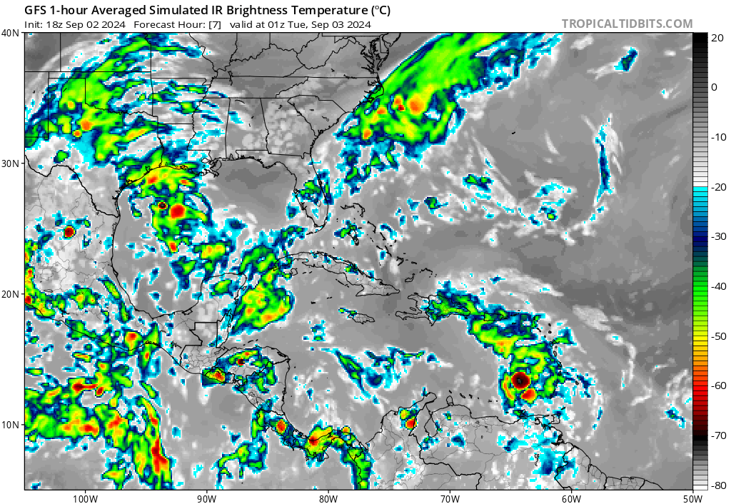
18Z EPS have more of the same, weak lows developing in the W. Caribbean before the AOI gets on the scene. I'd think anything trying to develop might help pull the system, if it develops, from the BoC. I still like the NHC 40% for a TD or TS. H isn't impossible, but not likely. Work tomorrow, cloud tops with the wave have warmed quite a bit, will be interesting to see satellite presentation and models when I wake up.
0 likes
Re: Tropical Wave in Eastern Caribbean (0/40)
WaveBreaking wrote:Teban54 wrote:MEANINGLESS_NUMBERS wrote:Happy hour GFS delivering as always.
Unlike most 18z runs, though, we should know whether it has merit in real time in just 12-18 hours. This run shows a big convective burst at 1z (3 hours from now) that continues for at least 6 hours (albeit fading out a bit at the next frame). If vorticity is still strong tomorrow morning, it would suggest 18z GFS may be catching up with short-term trends rather than doing typical happy hour stuff.
https://i.postimg.cc/gjHvKBh7/image.png
If this latest pulse of convection near the middle of the wave axis that Frank P pointed out maintains itself. Then the 18z run might be onto something.
https://i.imgur.com/BLnufBa.gif
Narrator: It didn't.
Remember someone said recently that DMIN now feels more convectively active than DMAX?
1 likes
TC naming lists: retirements and intensity
Most aggressive Advisory #1's in North Atlantic (cr. kevin for starting the list)
Most aggressive Advisory #1's in North Atlantic (cr. kevin for starting the list)
-
Stormlover70
- Tropical Storm

- Posts: 194
- Age: 56
- Joined: Fri Jun 21, 2024 5:31 am
- Location: New port richey
Re: Tropical Wave in Eastern Caribbean (0/40)
Nobody noticed the low coming into that? Looks more interesting than this wave.
0 likes
-
dexterlabio
- Category 5
- Posts: 3518
- Joined: Sat Oct 24, 2009 11:50 pm
Re: Tropical Wave in Eastern Caribbean (0/40)
What are the chances of this pulling off a Harvey?
0 likes
Personal Forecast Disclaimer:
The posts in this forum are NOT official forecast and should not be used as such. They are just the opinion of the poster and may or may not be backed by sound meteorological data. They are NOT endorsed by any professional institution or storm2k.org. For official information, please refer to the NHC and NWS products.
The posts in this forum are NOT official forecast and should not be used as such. They are just the opinion of the poster and may or may not be backed by sound meteorological data. They are NOT endorsed by any professional institution or storm2k.org. For official information, please refer to the NHC and NWS products.
Re: Tropical Wave in Eastern Caribbean (0/40)
dexterlabio wrote:What are the chances of this pulling off a Harvey?
Quite low there are no models indicating anything like that as of right now.
0 likes
Re: Tropical Wave in Eastern Caribbean (0/40)
IcyTundra wrote:dexterlabio wrote:What are the chances of this pulling off a Harvey?
Quite low there are no models indicating anything like that as of right now.
To be fair, I don't think models were expecting Harvey to become a Cat 4 until very close to its intensification, if not when it was already happening. At one point, even regeneration in the Gulf at all wasn't a guarantee.
That said, currently models seem to show persistent shear in the northern Gulf at least as far south as the US coastline, if not further. On the other hand, some Euro runs have an ULAC (?) near the US-Mexico border. I'm not sure how GFS has been bombing it out in the Gulf on some of its runs, but that could be what it's seeing. Either way, very low probability for now, but do note that many ensemble members that have the system picked up by a trough and moving north do have it intensify to a hurricane (though a small proportion of all members).
----------------------------------------
In other news, I'm totally lost as to why this wave has the tendency to just stop generating convection every time it's on the verge of improving. It's not a basin-wide problem either (although it's certainly easy to think so), as the two MDR waves have been bursting all night.
Last edited by Teban54 on Mon Sep 02, 2024 10:34 pm, edited 1 time in total.
0 likes
TC naming lists: retirements and intensity
Most aggressive Advisory #1's in North Atlantic (cr. kevin for starting the list)
Most aggressive Advisory #1's in North Atlantic (cr. kevin for starting the list)
-
skyline385

- Category 5
- Posts: 2728
- Age: 35
- Joined: Wed Aug 26, 2020 11:15 pm
- Location: Houston TX
Re: Tropical Wave in Eastern Caribbean (0/40)
ICON also develops the AOI after crossing Yucatan now

2 likes
-
Stratton23
- Category 5
- Posts: 3578
- Joined: Fri Jul 21, 2023 10:59 pm
- Location: Katy, Tx
Re: Tropical Wave in Eastern Caribbean (0/40)
Icon becomes a hurricane in the western gulf, looks to be moving north at the end of its run
0 likes
-
Frank P
- S2K Supporter
- Posts: 2779
- Joined: Fri Aug 29, 2003 10:52 am
- Location: Biloxi Beach, Ms
- Contact:
Re: Tropical Wave in Eastern Caribbean (0/40)
Stratton23 wrote:Icon becomes a hurricane in the western gulf, looks to be moving north at the end of its run
If you watch the Icon run in its entirety it looks to me the low currently off the TX coast drops down to the BOC as the Caribbean wave crosses the Yucatán and they merge creating the hurricane that eventually forms.. weird science right there
1 likes
Re: Tropical Wave in Eastern Caribbean (0/40)
Frank P wrote:Stratton23 wrote:Icon becomes a hurricane in the western gulf, looks to be moving north at the end of its run
If you watch the Icon run in its entirety it looks to me the low currently off the TX coast drops down to the BOC as the Caribbean wave crosses the Yucatán and they merge creating the hurricane that eventually forms.. weird science right there
I noticed that also. Curious to see if the 0z GFS or the 0z Euro show a similar setup
0 likes
-
skyline385
- Category 5
- Posts: 2728
- Age: 35
- Joined: Wed Aug 26, 2020 11:15 pm
- Location: Houston TX
Re: Tropical Wave in Eastern Caribbean (0/40)
LAF92 wrote:Frank P wrote:Stratton23 wrote:Icon becomes a hurricane in the western gulf, looks to be moving north at the end of its run
If you watch the Icon run in its entirety it looks to me the low currently off the TX coast drops down to the BOC as the Caribbean wave crosses the Yucatán and they merge creating the hurricane that eventually forms.. weird science right there
I noticed that also. Curious to see if the 0z GFS or the 0z Euro show a similar setup
There were EPS members already showing that so its definitely not limited to the ICON only
1 likes
-
Stratton23
- Category 5
- Posts: 3578
- Joined: Fri Jul 21, 2023 10:59 pm
- Location: Katy, Tx
Re: Tropical Wave in Eastern Caribbean (0/40)
And of course the GFS has nothing, the CMC still develops a TS though in the southern gulf, safe to say ensembles are still the way to go until we get consistent runs from the OP models
0 likes
-
Stratton23
- Category 5
- Posts: 3578
- Joined: Fri Jul 21, 2023 10:59 pm
- Location: Katy, Tx
Re: Tropical Wave in Eastern Caribbean (0/40)
GEFS has backed off on development, still a lot of uncertainty though
1 likes
-
MarioProtVI
- Category 5
- Posts: 1039
- Age: 24
- Joined: Sun Sep 29, 2019 7:33 pm
- Location: New Jersey
Re: Tropical Wave in Eastern Caribbean (0/40)
Stratton23 wrote:GEFS has backed off on development, still a lot of uncertainty though
Virtually no model develops it anymore. I think it’s time to drop chances as the GFS was really the only one still predicting development. The BoC/Western Gulf chances are a wild card and don’t even matter if the wave buries itself into Central America. To think the EPS on August 26 was saying we’d have a hurricane north of PR or so right now which ended up trending to basically nothing is
0 likes
Who is online
Users browsing this forum: Ulf and 108 guests