
Tropical Wave in Bay of Campeche (Is Invest 91L)
Moderator: S2k Moderators
Forum rules

The posts in this forum are NOT official forecasts and should not be used as such. They are just the opinion of the poster and may or may not be backed by sound meteorological data. They are NOT endorsed by any professional institution or STORM2K. For official information, please refer to products from the National Hurricane Center and National Weather Service.
-
WaveBreaking

- Category 2

- Posts: 728
- Joined: Sun Jun 30, 2024 11:33 am
- Location: US
Re: Tropical Wave in Eastern Caribbean (0/40)
18z has the wave dramatically ramp up from a 1000 mb depression to a strengthening 980 mb hurricane into the Yucatan. The only major difference between steering that I can find between the 12z and 18z is that the ridge over the N gulf is slightly stronger in the 18z run.
1 likes
I am NOT a professional meteorologist, so take all of my posts with a grain of salt. My opinions are mine and mine alone.
-
WaveBreaking
- Category 2
- Posts: 728
- Joined: Sun Jun 30, 2024 11:33 am
- Location: US
Re: Tropical Wave in Eastern Caribbean (0/40)
LadyBug72 wrote:skyline385 wrote:This is interesting, AIFS 12z suddenly got onboard the GoM system from the gyre over Yucatan (from our AOI) trend.
12z EPS also had an uptick in members showing that solution
https://i.imgur.com/T1MKfx5.png
https://i.imgur.com/4WgEUDs.png
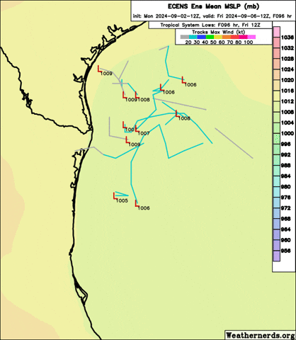
Can someone please explain what the different colored lines mean?
Each line is an area of low pressure that one of the members in the European Ensemble model group tries to develop. The color corresponds to the strength of a low pressure area developed by a member (the legend in the top right shows the pressure values associated with each color).
1 likes
I am NOT a professional meteorologist, so take all of my posts with a grain of salt. My opinions are mine and mine alone.
-
WaveBreaking
- Category 2
- Posts: 728
- Joined: Sun Jun 30, 2024 11:33 am
- Location: US
Re: Tropical Wave in Eastern Caribbean (0/40)
18z run decides to split the wave into two after getting buried in CA.

Last edited by WaveBreaking on Mon Sep 02, 2024 6:17 pm, edited 1 time in total.
1 likes
I am NOT a professional meteorologist, so take all of my posts with a grain of salt. My opinions are mine and mine alone.

Re: Tropical Wave in Eastern Caribbean (0/40)
WaveBreaking wrote:18z run decides the split the wave into two after getting buried in CA.
https://i.imgur.com/SU9UdB5.gif
This scenario had been shown on some earlier runs, and did happen in real life with Julia and Karl 2022.
2 likes
TC naming lists: retirements and intensity
Most aggressive Advisory #1's in North Atlantic (cr. kevin for starting the list)
Most aggressive Advisory #1's in North Atlantic (cr. kevin for starting the list)
-
Stratton23
- Category 5

- Posts: 3578
- Joined: Fri Jul 21, 2023 10:59 pm
- Location: Katy, Tx
Re: Tropical Wave in Eastern Caribbean (0/40)
While the GFS/ GEFS on this run goes into mexico, the upper air pattern is very tricky next week, the ridging on the GEFS isnt even all that strong and still has a weakness over the western- central gulf coast states, its just a question if something develops and feels that weakness
0 likes
-
cheezyWXguy

- Category 5
- Posts: 6282
- Joined: Mon Feb 13, 2006 12:29 am
- Location: Dallas, TX
Re: Tropical Wave in Eastern Caribbean (0/40)
The gfs’s evolution of this system after Mexico landfall seems strange, but does have some support from the gefs/eps. If steering currents do break down like that with a weakness to the north, it should have a fair amount of time to capitalize on warm waters and at least a decent environment
0 likes
Re: Tropical Wave in Eastern Caribbean (0/40)
Didn't know there are more than one Euro AI models. Apparently, the other two were much less trigger-happy worth genesis than AIFS was, but now all three show a BoC system heading north.
https://x.com/MassachusettsWx/status/1830742292866674858
https://x.com/MassachusettsWx/status/1830742292866674858
0 likes
TC naming lists: retirements and intensity
Most aggressive Advisory #1's in North Atlantic (cr. kevin for starting the list)
Most aggressive Advisory #1's in North Atlantic (cr. kevin for starting the list)
-
cajungal

- Category 5
- Posts: 2354
- Age: 49
- Joined: Sun Mar 14, 2004 9:34 pm
- Location: Schriever, Louisiana (60 miles southwest of New Orleans)
Re: Tropical Wave in Eastern Caribbean (0/40)
Teban54 wrote:Didn't know there are more than one Euro AI models. Apparently, the other two were much less trigger-happy worth genesis than AIFS was, but now all three show a BoC system heading north.
https://x.com/MassachusettsWx/status/1830742292866674858
I haven’t been watching as much today because been enjoying my Labor Day with nice weather and a pool day but a little surprised to see a model showing this as I am in Louisiana.
0 likes
-
TomballEd
- Category 5
- Posts: 1322
- Age: 62
- Joined: Wed Aug 16, 2023 4:52 pm
- Location: Spring/Klein area, not Tomball
Re: Tropical Wave in Eastern Caribbean (0/40)
The GFS solution is weird. Multiple TCs from the remnants of the AOI probably doesn't happy. Solution through one week is stronger than prior runs, and possible. A bit more N it could feel the trough bringing the first real Autumn cold front (dew points at or below 60F!) and come N.
10% of the 18Z ensembles do something possibly associated with the now 0% AOI, pushing lows S ahead of the front, which could interact, somehow, with this AOI. Feels like drawing to an inside straight, but I suppose the odds of something ICON-sh or 18Z GFS-ish happening are non-zero.
10% of the 18Z ensembles do something possibly associated with the now 0% AOI, pushing lows S ahead of the front, which could interact, somehow, with this AOI. Feels like drawing to an inside straight, but I suppose the odds of something ICON-sh or 18Z GFS-ish happening are non-zero.
0 likes
-
Weathertracker96
- Tropical Storm

- Posts: 150
- Joined: Mon Oct 16, 2023 3:41 pm
Re: Tropical Wave in Eastern Caribbean (0/40)
Does anyone what causes the GFS to send a system to FL in the latest run?
Is it related to this wave or is part of another wave?
It’s been showing up on some runs.
Is it related to this wave or is part of another wave?
It’s been showing up on some runs.
0 likes
-
cycloneye
- Admin

- Posts: 149730
- Age: 69
- Joined: Thu Oct 10, 2002 10:54 am
- Location: San Juan, Puerto Rico
Re: Tropical Wave in Eastern Caribbean (0/40)
Caribbean Sea:
A westward-moving tropical wave is producing disorganized showers
and thunderstorms accompanied by locally heavy rainfall and strong
gusty winds over portions of the eastern Caribbean Sea and the
adjacent land areas. Environmental conditions are forecast to
become more conducive for development when the system reaches the
western Caribbean Sea and southwestern Gulf of Mexico late this week
and over the weekend, and a tropical depression could form during
that time.
* Formation chance through 48 hours...low...near 0 percent.
* Formation chance through 7 days...medium...40 percent.
0 likes
Visit the Caribbean-Central America Weather Thread where you can find at first post web cams,radars
and observations from Caribbean basin members Click Here
and observations from Caribbean basin members Click Here
-
Stratton23
- Category 5
- Posts: 3578
- Joined: Fri Jul 21, 2023 10:59 pm
- Location: Katy, Tx
Re: Tropical Wave in Eastern Caribbean (0/40)
NHC is being too conservative again, i really think they should have upped this to 50% at the 8 pm update
0 likes
-
ThunderForce

- Tropical Storm
- Posts: 208
- Age: 26
- Joined: Tue Sep 27, 2022 6:20 pm
- Location: Calhoun County, Florida
Re: Tropical Wave in Eastern Caribbean (0/40)
Oddly a lot of the 18z GEFS ensembles seem a bit faster than the operational model with this tropical wave.
0 likes
Please refer to the NWS, NHC, SPC or a professional meteorologist for information and decision making during storms.
-
Spacecoast

- Category 2
- Posts: 773
- Joined: Thu Aug 31, 2017 2:03 pm
Re: Tropical Wave in Eastern Caribbean (0/40)
Teban54 wrote:Didn't know there are more than one Euro AI models. Apparently, the other two were much less trigger-happy worth genesis than AIFS was, but now all three show a BoC system heading north.
https://x.com/MassachusettsWx/status/1830742292866674858
Actually more than three....
Here's a link to ECMWF Experimentals...
https://charts.ecmwf.int/?facets=%7B%22Product%20type%22%3A%5B%22Experimental%3A%20Machine%20learning%20models%22%5D%7D
There's also GFS version of Graphcast on Pivotal
0 likes

Re: Tropical Wave in Eastern Caribbean (0/40)
ThunderForce wrote:Oddly a lot of the 18z GEFS ensembles seem a bit faster than the operational model with this tropical wave.
Euro still doesn't develop it and the GFS has been off and on, so more likely there isn't enough confidence right now
0 likes
The above post is not official and should not be used as such. It is the opinion of the poster and may or may not be backed by sound meteorological data. It is not endorsed by any professional institution or storm2k.org. For official information, please refer to the NHC and NWS products.
-
Stratton23
- Category 5
- Posts: 3578
- Joined: Fri Jul 21, 2023 10:59 pm
- Location: Katy, Tx
Re: Tropical Wave in Eastern Caribbean (0/40)
The euro OP will eventually cave in to the ensemble, happens almost every time with that model, at least 20 of the 50 members show development, thats pretty good, the GFS is starting to show a more consistent run to run variance in terms of development, not strength , id frankly be shocked if the NHC didnt up chances at 2 am
0 likes
-
Craters
- Category 1

- Posts: 428
- Joined: Sat Aug 24, 2013 2:34 pm
- Location: Alvin, TX (south of Houston)
Re: Tropical Wave in Eastern Caribbean (0/40)
WaveBreaking wrote:LadyBug72 wrote:skyline385 wrote:This is interesting, AIFS 12z suddenly got onboard the GoM system from the gyre over Yucatan (from our AOI) trend.
12z EPS also had an uptick in members showing that solution
https://i.imgur.com/T1MKfx5.png
https://i.imgur.com/4WgEUDs.png
Can someone please explain what the different colored lines mean?
Each line is an area of low pressure that one of the members in the European Ensemble model group tries to develop. The color corresponds to the strength of a low pressure area developed by a member (the legend in the top right shows the pressure values associated with each color).
And just to add a bit to WaveBreaking's nice, concise explanation, 1 hPa (hectoPascal) = 1 millibar.
You'll see these "ensemble" plots here fairly often. One thing you'll probably notice after seeing a bunch of them is, all other things being equal under "normal" (!) conditions, the redder and pinker tracks (indicating stronger storms) will have more northerly components to their motion, since stronger storms want to head north. The bluer and greener (weaker) ones are steered more commonly by the prevailing, lower-altitude winds winds at these latitudes.
1 likes
Nothing that I post here should ever be treated as a forecast or anything resembling one. Please check with your local NWS office or the NHC for forecasts, watches, and warnings.
-
TomballEd
- Category 5
- Posts: 1322
- Age: 62
- Joined: Wed Aug 16, 2023 4:52 pm
- Location: Spring/Klein area, not Tomball
Re: Tropical Wave in Eastern Caribbean (0/40)
Stratton23 wrote:The euro OP will eventually cave in to the ensemble, happens almost every time with that model, at least 20 of the 50 members show development, thats pretty good, the GFS is starting to show a more consistent run to run variance in terms of development, not strength , id frankly be shocked if the NHC didnt up chances at 2 am
A lot of those 10-20 knot or 20-30 knot TDs and minimal TCs are not from the AOI.
The 40% is too low, Dr. Pasch at NHC is making a mistake? Besides having been a professor at both Miami and Florida State, he was a visiting science at ECMWF in England.
Last edited by TomballEd on Mon Sep 02, 2024 7:51 pm, edited 1 time in total.
0 likes
-
Frank P
- S2K Supporter

- Posts: 2779
- Joined: Fri Aug 29, 2003 10:52 am
- Location: Biloxi Beach, Ms
- Contact:
Re: Tropical Wave in Eastern Caribbean (0/40)
Stratton23 wrote:The euro OP will eventually cave in to the ensemble, happens almost every time with that model, at least 20 of the 50 members show development, thats pretty good, the GFS is starting to show a more consistent run to run variance in terms of development, not strength , id frankly be shocked if the NHC didnt up chances at 2 am
I wonder if they take into account the AI models, anyone ever remember when they might have referenced it in a Storm discussion, I don’t recall. Per the IR images convection is really cooling down tonight. I doubt they will increase the percentages based on Sat imagery, unless some big changes occur in the OOz runs this later this evening.
Last edited by Frank P on Mon Sep 02, 2024 7:50 pm, edited 1 time in total.
0 likes
-
Stratton23
- Category 5
- Posts: 3578
- Joined: Fri Jul 21, 2023 10:59 pm
- Location: Katy, Tx
Re: Tropical Wave in Eastern Caribbean (0/40)
TomballEd yes 40% is too low in my opinion, their has been enough uptick in ensemble support and global runs to justify that, the NHC is great at what they do, but they definitely do have a history of being too conservative with development chances
2 likes
Who is online
Users browsing this forum: No registered users and 119 guests