
06z EC AI - stronger ridging to the system’s east. Conus low is farther east than the other 3 models and centered over NW Arkansas. Draws the system in and flings it NW inland into the cutoff.
https://www.pivotalweather.com/model.ph ... &dpdt=&mc=
Low pressure developing over the western Caribbean Sea (Is Invest 97L)
Moderator: S2k Moderators
Forum rules

The posts in this forum are NOT official forecasts and should not be used as such. They are just the opinion of the poster and may or may not be backed by sound meteorological data. They are NOT endorsed by any professional institution or STORM2K. For official information, please refer to products from the National Hurricane Center and National Weather Service.
-
ConvergenceZone
.gif)
- Category 5

- Posts: 5241
- Joined: Fri Jul 29, 2005 1:40 am
- Location: Northern California
Re: Area of low pressure to develop over the western Caribbean sea (0/60)
gatorcane wrote:12Z models suggesting there could be wind shear across the GOM, especially northern GOM not to mention the system could be very large and not really able to consolidate prior to landfall along the north-Central Gulf coast. Also seems there is a good amount of dry across the WGOM and South-Central US that gets entrained into the system as it moves north. Most of the squalls and rainfall could be on the eastern side of whatever develops. Good news, hopefully it continues.
I think the main concern is rain. Even if the dry air and shear materializes as forecasted and it doesn't quite make it hurricane strength, the tropical storm is shown to be very large, so lots of rain.
0 likes
Re: Area of low pressure to develop over the western Caribbean sea (0/60)
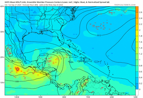
So assuming these 4 models upper patterns are blended, we would have a storm landfalling in the 990s coming in between N and NNE then getting sucked back NW into the trough. GFS gets the farthest east inland before getting drawn in. Last couple days we’ve been looking at a more likely landfall late next weekend or Monday. Now everything is moved up to end of next week and weaker. Still looks to be an event but more of a nuisance than a major threat. Landfall would be between Grand Isle and Destin.
1 likes
Re: Area of low pressure to develop over the western Caribbean sea (0/60)
It seems like this is a situation where extra balloons and soundings across the CONUS might be helpful to help the models get a better handle on the upper air dynamics?
3 likes
-
TomballEd
- Category 5
- Posts: 1322
- Age: 62
- Joined: Wed Aug 16, 2023 4:52 pm
- Location: Spring/Klein area, not Tomball
Re: Area of low pressure to develop over the western Caribbean sea (0/60)
Jr0d wrote:As always, the future tracks is iffy until we have something to track. I expect the current thunderstorm activity off of Honduras to fizzle again.
What is really starting to concern me is the the CMC and GFS seem to agree that whatever develops will be a large system, with the circulation and bands over more than half of the GoM, which could make storm flooding a major issue for all of the Florida Gulf Coast.
https://i.ibb.co/tPtVX9J/gem-ir-watl-22.png
https://i.ibb.co/S6fyBY3/gfs-ir-watl-20.png
Large systems tend to develop when there is a large area of abundant moisture. Systems in otherwise favorable conditions will form, but their size tends to be limited by proximity to drier air. Not an issue here. Plenty of mid level humidity/high PW in the Caribbean. GFS is still strengthening at landfall, CMS starting to weaken, I believe related to when the two models think the shear will be strong enough to push dry air into the circulation. Farther S development has been suggested by prior runs of the Euro. The end result is still the N Gulf to Florida, no matter how far W it gets into the Gulf. Note GFS ensembles still have some members that never get out of the BoC, a couple of W outliers that offer hope to people who'd rather see Florida get spared, but the GEFS, while they haven't really pegged a landfall location yet, are almost all into Florida.
Last edited by TomballEd on Sat Sep 21, 2024 12:36 pm, edited 1 time in total.
4 likes
-
MarioProtVI
- Category 5
- Posts: 1039
- Age: 24
- Joined: Sun Sep 29, 2019 7:33 pm
- Location: New Jersey
Re: Area of low pressure to develop over the western Caribbean sea (0/60)
Looks like this unmarked disturbance in EPac will be why this ends up being nothing more then a sloppy system - it interacts with the CAG enough to keep the AOI very broad and weak. Models seem to be shifting towards this now with a notable downtrend in intensity among ensemble members. Seems like September could go without a single major (I do not have expectations for the MDR storm given GFS is the only one showing anything remotely strong there and it tends to be overzealous there). Good for GoM people as it’ll likely be nothing more then a typical June tropical storm setup (thinking Cindy 2017-like). The curse of 2024 continues…

Last edited by MarioProtVI on Sat Sep 21, 2024 12:39 pm, edited 1 time in total.
3 likes
-
StPeteMike

- Category 2

- Posts: 657
- Joined: Thu Jun 07, 2018 11:26 pm
Re: Area of low pressure to develop over the western Caribbean sea (0/60)
bjackrian wrote:It seems like this is a situation where extra balloons and soundings across the CONUS might be helpful to help the models get a better handle on the upper air dynamics?
Definitely! For years it’s been like this, where we needed more balloons to sample the upper air conditions.
0 likes
The above post is not official and should not be used as such. It is the opinion of the poster and may or may not be backed by sound meteorological data. It is not endorsed by any professional institution or storm2k.org. For official information, please refer to the NHC and NWS products.

Re: Area of low pressure to develop over the western Caribbean sea (0/60)
MarioProtVI wrote:Looks like this unmarked disturbance in EPac will be why this ends up being nothing more then a sloppy system - it interacts with the CAG enough to keep the AOI very broad and weak. Models seem to be shifting towards this now with a notable downtrend in intensity among ensemble members. Seems like September could go with a single major (I do not have expectations for the MDR storm given GFS is the only one showing anything remotely strong there and it tends to be overzealous there). Good for GoM people as it’ll likely be nothing more then a typical June tropical storm setup (thinking Cindy 2017-like). The curse of 2024 continues…
My thinking is the weak trend has a lot more to do with the trough cutting off and deepening vs moving out very quickly. On all the 12z runs so far you can see it lingering around Oklahoma. This breaks down the ridge much faster, shooting the gyre north with very little time to consolidate. This placement and high forward speed would also increase shear. Note that several very strong GFS runs still had that Epac thing developing.
2 likes
Kendall -> SLO -> PBC
Memorable Storms: Katrina (for its Florida landfall...) Wilma Matthew Irma
Memorable Storms: Katrina (for its Florida landfall...) Wilma Matthew Irma
-
ElectricStorm

- Category 5
- Posts: 5156
- Age: 25
- Joined: Tue Aug 13, 2019 11:23 pm
- Location: Norman, OK
Re: Area of low pressure to develop over the western Caribbean sea (0/60)
MarioProtVI wrote:Looks like this unmarked disturbance in EPac will be why this ends up being nothing more then a sloppy system - it interacts with the CAG enough to keep the AOI very broad and weak. Models seem to be shifting towards this now with a notable downtrend in intensity among ensemble members. Seems like September could go with a single major (I do not have expectations for the MDR storm given GFS is the only one showing anything remotely strong there and it tends to be overzealous there). Good for GoM people as it’ll likely be nothing more then a typical June tropical storm setup (thinking Cindy 2017-like). The curse of 2024 continues…
https://media.discordapp.net/attachments/783987504071573517/1287101254358536192/msfc.gif?ex=66f051f4&is=66ef0074&hm=8a24f8ca188552094922d67c786eaa62b910c676d53e6753467744e43f2d5a69&
Yeah surprised this hasn't been added on the TWO yet. Pretty solid model support for something developing near the Mexico coast throwing shear on the Atlantic disturbance
0 likes
B.S Meteorology, University of Oklahoma '25
Please refer to the NHC, NWS, or SPC for official information.
Please refer to the NHC, NWS, or SPC for official information.
Re: Area of low pressure to develop over the western Caribbean sea (0/60)
MarioProtVI wrote:Looks like this unmarked disturbance in EPac will be why this ends up being nothing more then a sloppy system - it interacts with the CAG enough to keep the AOI very broad and weak. Models seem to be shifting towards this now with a notable downtrend in intensity among ensemble members. Seems like September could go with a single major (I do not have expectations for the MDR storm given GFS is the only one showing anything remotely strong there and it tends to be overzealous there). Good for GoM people as it’ll likely be nothing more then a typical June tropical storm setup (thinking Cindy 2017-like). The curse of 2024 continues…
https://media.discordapp.net/attachments/783987504071573517/1287101254358536192/msfc.gif?ex=66f051f4&is=66ef0074&hm=8a24f8ca188552094922d67c786eaa62b910c676d53e6753467744e43f2d5a69&
And is there anything bad about this type of curse, should this end up a mess of a system? I mean what area wants a hurricane no matter how weak it is?
0 likes
-
TomballEd
- Category 5
- Posts: 1322
- Age: 62
- Joined: Wed Aug 16, 2023 4:52 pm
- Location: Spring/Klein area, not Tomball
Re: Area of low pressure to develop over the western Caribbean sea (0/60)
MarioProtVI wrote:Looks like this unmarked disturbance in EPac will be why this ends up being nothing more then a sloppy system - it interacts with the CAG enough to keep the AOI very broad and weak. Models seem to be shifting towards this now with a notable downtrend in intensity among ensemble members. Seems like September could go with a single major (I do not have expectations for the MDR storm given GFS is the only one showing anything remotely strong there and it tends to be overzealous there). Good for GoM people as it’ll likely be nothing more then a typical June tropical storm setup (thinking Cindy 2017-like). The curse of 2024 continues…
https://media.discordapp.net/attachments/783987504071573517/1287101254358536192/msfc.gif?ex=66f051f4&is=66ef0074&hm=8a24f8ca188552094922d67c786eaa62b910c676d53e6753467744e43f2d5a69&
Too soon for that call, I see a member in the 930s, likely an outlier. But I see enough systems in the 950's and 960's, a system as strong as a Cat 3 is possible. I expect a Cat 1 or Cat 2, which probably gets somewhat maintained as it approaches the strong shear by the strong W-lies and SW-lies that will aid the evacuation of air and create extra lift before the shear can push dry air into the system.
0 likes

Re: Area of low pressure to develop over the western Caribbean sea (0/60)
Steve wrote:So assuming these 4 models upper patterns are blended, we would have a storm landfalling in the 990s coming in between N and NNE then getting sucked back NW into the trough. GFS gets the farthest east inland before getting drawn in. Last couple days we’ve been looking at a more likely landfall late next weekend or Monday. Now everything is moved up to end of next week and weaker. Still looks to be an event but more of a nuisance than a major threat. Landfall would be between Grand Isle and Destin.
Quite concerned for the rainfall potential in these set ups, particularly if it slows down over land, which doesn’t appear to be the case. That would be a nightmare. Very large, disorganized system seems to be the “trend”, which I use loosely. But there does appear to be some sort of consolidation within the models. Lots of variables and tomorrow is a new day with more data.
1 likes
-
emeraldislenc
- Category 2
- Posts: 602
- Joined: Fri Aug 24, 2012 4:49 pm
- Location: Emerald Isle NC
Re: Area of low pressure to develop over the western Caribbean sea (0/60)
I think it is way to early to say good for gulf coast. Nothing has even formed yet! Just my thoughts!
4 likes
-
TomballEd
- Category 5
- Posts: 1322
- Age: 62
- Joined: Wed Aug 16, 2023 4:52 pm
- Location: Spring/Klein area, not Tomball
Re: Area of low pressure to develop over the western Caribbean sea (0/60)
Area off Mexico stays weak, and the upper winds over the unformed Caribbean system is from the E, or it may reduce shear for the developing system. It will compete for low level flow somewhat,
Mexican system is gone from the scene by the time GFS shows this cranking in the Gulf. Or I think it may slow the system, what Joe Bastardi (I used to subscribe to WxBell until they raised my rates) calls two pigs fighting at the trough, except the Pacific pig is at the other end of the trough and leaves when the system is still in the Caribbean.
Mexican system is gone from the scene by the time GFS shows this cranking in the Gulf. Or I think it may slow the system, what Joe Bastardi (I used to subscribe to WxBell until they raised my rates) calls two pigs fighting at the trough, except the Pacific pig is at the other end of the trough and leaves when the system is still in the Caribbean.
Last edited by TomballEd on Sat Sep 21, 2024 12:45 pm, edited 1 time in total.
0 likes
-
ConvergenceZone
- Category 5
- Posts: 5241
- Joined: Fri Jul 29, 2005 1:40 am
- Location: Northern California
Re: Area of low pressure to develop over the western Caribbean sea (0/60)
MarioProtVI wrote:Looks like this unmarked disturbance in EPac will be why this ends up being nothing more then a sloppy system - it interacts with the CAG enough to keep the AOI very broad and weak. Models seem to be shifting towards this now with a notable downtrend in intensity among ensemble members. Seems like September could go without a single major (I do not have expectations for the MDR storm given GFS is the only one showing anything remotely strong there and it tends to be overzealous there). Good for GoM people as it’ll likely be nothing more then a typical June tropical storm setup (thinking Cindy 2017-like). The curse of 2024 continues…
https://media.discordapp.net/attachments/783987504071573517/1287101254358536192/msfc.gif?ex=66f051f4&is=66ef0074&hm=8a24f8ca188552094922d67c786eaa62b910c676d53e6753467744e43f2d5a69&
True, but even if this is ends up being only a mid grade tropical storm, the rain can still cause lot of issues, depending upon how fast it moves. But you are right, doesn't really look like it will amount to much, especially based on how long it's forecasted to take to even become a system. I'm going with strong tropical storm right now, but we'll see. It can still become a hurricane.
0 likes
-
toad strangler

- S2K Supporter

- Posts: 4546
- Joined: Sun Jul 28, 2013 3:09 pm
- Location: Earth
- Contact:
Re: Area of low pressure to develop over the western Caribbean sea (0/60)
3090 wrote:MarioProtVI wrote:Looks like this unmarked disturbance in EPac will be why this ends up being nothing more then a sloppy system - it interacts with the CAG enough to keep the AOI very broad and weak. Models seem to be shifting towards this now with a notable downtrend in intensity among ensemble members. Seems like September could go with a single major (I do not have expectations for the MDR storm given GFS is the only one showing anything remotely strong there and it tends to be overzealous there). Good for GoM people as it’ll likely be nothing more then a typical June tropical storm setup (thinking Cindy 2017-like). The curse of 2024 continues…
https://media.discordapp.net/attachments/783987504071573517/1287101254358536192/msfc.gif?ex=66f051f4&is=66ef0074&hm=8a24f8ca188552094922d67c786eaa62b910c676d53e6753467744e43f2d5a69&
And is there anything bad about this type of curse, should this end up a mess of a system? I mean what area wants a hurricane no matter how weak it is?
It would be a blessing to get a sloppy mess!
2 likes
My Weather Station
https://www.wunderground.com/dashboard/pws/KFLPORTS603
https://www.wunderground.com/dashboard/pws/KFLPORTS603
Re: Area of low pressure to develop over the western Caribbean sea (0/60)
Latest GFS 500mb pattern now has the cutoff low positioned over the Arkansas/Texas/Louisiana border instead of the northeast. This is a major change to the upstream weather pattern that would have an impact on the future path of whatever develops. More north/north-northwest and no northeast/east path. AGAIN though, there is nothing of a system. Just upstream models that will have a impact.
1 likes
Re: Area of low pressure to develop over the western Caribbean sea (0/60)
What reliable models are showing the low CAT3 hurricane? I have not seen one. Thanks!TomballEd wrote:MarioProtVI wrote:Looks like this unmarked disturbance in EPac will be why this ends up being nothing more then a sloppy system - it interacts with the CAG enough to keep the AOI very broad and weak. Models seem to be shifting towards this now with a notable downtrend in intensity among ensemble members. Seems like September could go with a single major (I do not have expectations for the MDR storm given GFS is the only one showing anything remotely strong there and it tends to be overzealous there). Good for GoM people as it’ll likely be nothing more then a typical June tropical storm setup (thinking Cindy 2017-like). The curse of 2024 continues…
https://media.discordapp.net/attachments/783987504071573517/1287101254358536192/msfc.gif?ex=66f051f4&is=66ef0074&hm=8a24f8ca188552094922d67c786eaa62b910c676d53e6753467744e43f2d5a69&
Too soon for that call, I see a member in the 930s, likely an outlier. But I see enough systems in the 950's and 960's, a system as strong as a Cat 3 is possible. I expect a Cat 1 or Cat 2, which probably gets somewhat maintained as it approaches the strong shear by the strong W-lies and SW-lies that will aid the evacuation of air and create extra lift before the shear can push dry air into the system.
1 likes
-
TomballEd
- Category 5
- Posts: 1322
- Age: 62
- Joined: Wed Aug 16, 2023 4:52 pm
- Location: Spring/Klein area, not Tomball
Re: Area of low pressure to develop over the western Caribbean sea (0/60)
TomballEd wrote:Area off Mexico stays weak, and the upper winds over the unformed Caribbean system is from the E, or it may reduce shear for the developing system. It will compete for low level flow somewhat,
Mexican system is gone from the scene by the time GFS shows this cranking in the Gulf. Or I think it may slow the system, what Joe Bastardi (I used to subscribe to WxBell until they raised my rates) calls two pigs fighting at the trough, except the Pacific pig is at the other end of the trough and leaves when the system is still in the Caribbean.
To add, the Pacific system's outflow may actually enhance developing anticyclonic outflow over the top. Run the GFS to the end for what would be a major in the Gulf about to hook a right toward the E. Gulf Some GEFS see a W. Caribbean signal to. Would add that to the 16 day model thread, but nobody should be watching Class A baseball when we have a AA player who might skip straight to the majors (probably not a MH, but enough ensembles still have that not to dismiss totally)
0 likes

Re: Area of low pressure to develop over the western Caribbean sea (0/60)
2024 post-Beryl:
1. Models show a strong hurricane impacting the U.S. “This will be the big one!” everyone thinks.
2. Models become increasingly unenthusiastic and the system either fails to form or is sloppier than expected.
Not saying this is a guaranteed outcome with this one, but I’m leaning towards it.
1. Models show a strong hurricane impacting the U.S. “This will be the big one!” everyone thinks.
2. Models become increasingly unenthusiastic and the system either fails to form or is sloppier than expected.
Not saying this is a guaranteed outcome with this one, but I’m leaning towards it.
5 likes
Igor 2010, Sandy 2012, Fay 2014, Gonzalo 2014, Joaquin 2015, Nicole 2016, Humberto 2019, Imelda 2025
I am only a tropical weather enthusiast. My predictions are not official and may or may not be backed by sound meteorological data. For official information, please refer to the NHC and NWS products.
I am only a tropical weather enthusiast. My predictions are not official and may or may not be backed by sound meteorological data. For official information, please refer to the NHC and NWS products.
Who is online
Users browsing this forum: No registered users and 110 guests