Doomsday storms

This is the general tropical discussion area. Anyone can take their shot at predicting a storms path.

Moderator: S2k Moderators

Forum rules

The posts in this forum are NOT official forecasts and should not be used as such. They are just the opinion of the poster and may or may not be backed by sound meteorological data. They are NOT endorsed by any professional institution or STORM2K. For official information, please refer to products from the National Hurricane Center and National Weather Service.

Help Support Storm2K
Message
Author
User avatar
jdray
Category 3
Category 3
Posts: 853
Joined: Tue Aug 31, 2004 10:07 pm
Location: NE Florida

#81 Postby jdray » Thu Feb 23, 2006 8:51 am

Derek Ortt wrote:20 foot surge at Miami Beach?

Please try and be realistic with these unlikely scenarios. It just is not possible for any place on the EC of Florida to have a surge over 15, and even 10 is nearly impossible and would take a Katrina sized cat 5. The reaosn is the same shelf profile as Cayman. Only Biscayne Bay would see a surge of 15 to 20 feet, but even that would be mitigated by a 15 foot high ridge line near the Bay.

A cane in Miami,e specially a major, is a pure wind event


I would think that Jacksonville due to the mouth of the St Johns River could see 20-30 foot possible surge with the right storm and tracking.

Dora in 1964 caused a 7.5 foot surge well inland on the St Johns due to topography and she was a mere Cat 2 in strength.

https://www.cnmoc.navy.mil/nmosw/tr8203 ... tab5-4.htm
This shows that a storm that did a 4.5 surge at Mayport was almost 9 feet in downtown Jacksonville.

Had Dora been a Katrina type event, downtown Jacksonville would have had a surge of over 15 feet if not 20. And we are talking 20 miles inland.


https://www.cnmoc.navy.mil/nmosw/tr8203 ... tab5-5.htm
Worst case SLOSH models from the Naval Base @ Mayport.
0 likes   

Derek Ortt

#82 Postby Derek Ortt » Thu Feb 23, 2006 10:27 am

Jacksonville, maybe, because the water is shallower that far north, like at Georgia
0 likes   

Jim Cantore

#83 Postby Jim Cantore » Thu Feb 23, 2006 1:13 pm

Image

Image

Image

Image

Image
0 likes   

User avatar
vbhoutex
Storm2k Executive
Storm2k Executive
Posts: 29114
Age: 73
Joined: Wed Oct 09, 2002 11:31 pm
Location: Cypress, TX
Contact:

#84 Postby vbhoutex » Thu Feb 23, 2006 2:37 pm

That's right, just keep those doomsday storms away from Houston and Galveston!!!!
0 likes   

Weatherfreak000

#85 Postby Weatherfreak000 » Thu Feb 23, 2006 7:30 pm

Here's some more for you guys....and yes I am evil lol.


A Wilma like disaster set-up with an added Cat 5 Carribean disaster and East Coast nail to boot...

Image


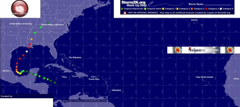
Here's a nasty Mexico Flood that sets up to do an Opal-ish curve and does Worst WORST case scenario for New Orleans

Image


Here's an interesting idea I had...... it sets up as a Cat 5 that makes partial landfall into South Carolina then parallels the East Coast as a Cat 2 with little movement causing harsh flooding and then going in thru Florida as a modest Cat 2. The storm then loses almost all of it's convection before getting dumped into the GOM before hitting the Gulf Current and powering back up to a Cat 2 again into Texas and then as a slow moving Depression dumping tons of rain over New Orleans.

Image
0 likes   

User avatar
cheezyWXguy
Category 5
Category 5
Posts: 6132
Joined: Mon Feb 13, 2006 12:29 am
Location: Dallas, TX

#86 Postby cheezyWXguy » Thu Feb 23, 2006 7:38 pm

Im sorry but thats probably the most unethical hurricane prediction Ive ever seen-no offense :wink:

wen I saw that I sat there for about five minutes looking at that last scenario you posted, trying to find ways to make a hurricane do this...lol
0 likes   

Weatherfreak000

#87 Postby Weatherfreak000 » Thu Feb 23, 2006 8:21 pm

cheezywxman wrote:Im sorry but thats probably the most unethical hurricane prediction Ive ever seen-no offense :wink:

wen I saw that I sat there for about five minutes looking at that last scenario you posted, trying to find ways to make a hurricane do this...lol


Yeah and I suppose we can sit here and debate on exactly how possible it really is to see A Cat 5 hit the Northern Gulf Coast or a Depression immediately developing into a Cat 5 then making landfall in Lousiana or perhaps a Cat 5 making it's way up to NYC for a nice strike.

Don't read into it so much :wink: the scenarios that are plausible are obvious as much as the ones that aren't.
0 likes   

User avatar
SouthFloridawx
S2K Supporter
S2K Supporter
Posts: 8346
Age: 46
Joined: Tue Jul 26, 2005 1:16 am
Location: Sarasota, FL
Contact:

#88 Postby SouthFloridawx » Thu Feb 23, 2006 8:22 pm

here is one I thought of ...

Image
0 likes   

CHRISTY

#89 Postby CHRISTY » Thu Feb 23, 2006 8:40 pm

wow.....
0 likes   

spinfan4eva
Category 1
Category 1
Posts: 295
Joined: Tue Aug 23, 2005 1:27 am
Location: Jacksonville, Florida
Contact:

#90 Postby spinfan4eva » Thu Feb 23, 2006 9:36 pm

Hope no one mentioned this one but all the images dont show up for me...

Here's one that has happenned before which if it happenned tomorrow, would devastate the florida peninsula and then slam the coast from the carolinas to new england rolling over Long Island as a Cat2 before weakenning below Hurricane status in Northern Maine. Image
0 likes   

User avatar
Hybridstorm_November2001
S2K Supporter
S2K Supporter
Posts: 2813
Joined: Sat Aug 21, 2004 2:50 pm
Location: SW New Brunswick, Canada
Contact:

#91 Postby Hybridstorm_November2001 » Thu Feb 23, 2006 9:51 pm

Ah Hurricane Donna of 1960, before my time LOL. I recall in 2004 everyone thought good ol' Charley would be a repeat, but was really a non-event in the region. Just a couple of showers along the Coast to the south of my own area for example.
0 likes   

JonathanBelles
Professional-Met
Professional-Met
Posts: 11430
Age: 35
Joined: Sat Dec 24, 2005 9:00 pm
Location: School: Florida State University (Tallahassee, FL) Home: St. Petersburg, Florida
Contact:

#92 Postby JonathanBelles » Thu Feb 23, 2006 10:00 pm

Hybridstorm_November2001 wrote:Ah Hurricane Donna of 1960, before my time LOL. I recall in 2004 everyone thought good ol' Charley would be a repeat, but was really a non-event in the region. Just a couple of showers along the Coast to the south of my own area for example.


charley 2004? i do not agree
0 likes   

User avatar
Hybridstorm_November2001
S2K Supporter
S2K Supporter
Posts: 2813
Joined: Sat Aug 21, 2004 2:50 pm
Location: SW New Brunswick, Canada
Contact:

#93 Postby Hybridstorm_November2001 » Thu Feb 23, 2006 10:05 pm

I mean up here it was nothing. Of course it was VERY INTENSE down in Florida, but crossing land ripped it apart, and it never really recovered. I mean it was no Donna, in terms of East Coast (other than Florida) event anyhow.
0 likes   

Derek Ortt

#94 Postby Derek Ortt » Thu Feb 23, 2006 10:21 pm

I beleive it was the shear that really did in Charley. The small size caused it to weaken quicker than expected over land (saved Orlando from severe damage to being leveled), but the shear prevented re-intensification over the Atlantic and really spared the Carolinas from a major disaster
0 likes   

Jim Cantore

#95 Postby Jim Cantore » Thu Feb 23, 2006 11:34 pm

According to SLOSH, this would toss a 32 foot surge into NYC

Image
0 likes   

whereverwx
Category 5
Category 5
Posts: 1109
Joined: Mon May 31, 2004 10:15 pm

#96 Postby whereverwx » Thu Feb 23, 2006 11:58 pm

Image
0 likes   

Jim Cantore

#97 Postby Jim Cantore » Fri Feb 24, 2006 12:06 am

theres an ugly season
0 likes   

User avatar
cheezyWXguy
Category 5
Category 5
Posts: 6132
Joined: Mon Feb 13, 2006 12:29 am
Location: Dallas, TX

#98 Postby cheezyWXguy » Fri Feb 24, 2006 8:18 am

the track at the bottom looks similar to Mitch after it leaves central america...do yall think so?
0 likes   

Jim Cantore

#99 Postby Jim Cantore » Fri Feb 24, 2006 11:02 pm

cheezywxman wrote:
Hurricane Floyd wrote:this on the other hand...........

Image


when this caught my eye i just couldnt stop laffing
:lol: :cheesy:


thats about as likely as Ethel actully being a cat 5 :lol:
0 likes   

Jim Cantore

#100 Postby Jim Cantore » Fri Feb 24, 2006 11:21 pm

these are the ultimate worst ones I could think of

lets start with the most likely

Image

Landfalls

Euthura Island: 170mph
Miami beach: 170mph
Grand Isle: 155mph

Aftermath: Miami is left in ruins, New orleans is under completely, the pumps are destroyed, the water is 10+ feet higher then Katrina, overall 50,000 deaths, many more missing, damages over $400 Billion

Now the more unlikely storm, this is the ultimate horror


Image

Landfalls

Point Pleasant: 140mph (moving NW at 40mph)

Aftermath: SLOSH estimates a 32 foot surge in NYC from this, a large storm with an outer eyewall floods the Jersey and NYC, Kills 100,000 people and causes $500 Billion in damage, total devestation[/img]
0 likes   


Return to “Talkin' Tropics”

Who is online

Users browsing this forum: Hurricaneman and 67 guests