https://twitter.com/andyhazelton/status/1562894302279192576
Low Pressure in the Central Atlantic (Is Invest 91L)
Moderator: S2k Moderators
Forum rules

The posts in this forum are NOT official forecasts and should not be used as such. They are just the opinion of the poster and may or may not be backed by sound meteorological data. They are NOT endorsed by any professional institution or STORM2K. For official information, please refer to products from the National Hurricane Center and National Weather Service.
-
skyline385

- Category 5

- Posts: 2728
- Age: 35
- Joined: Wed Aug 26, 2020 11:15 pm
- Location: Houston TX
Re: Tropical Wave Near the Cabo Verde Islands
Recent loop, strong convection along the wave axis but there seems to be dry air issues near the periphery killing the cold tops off


1 likes
-
InfernoFlameCat

- Category 5
- Posts: 2127
- Age: 23
- Joined: Mon Dec 14, 2020 10:52 am
- Location: Buford, GA
Re: Tropical Wave Near the Cabo Verde Islands
If the area of convection keeps persisting like this, some sort of surface low will eventually organize. At the very least, it will provide ample moisture to the wave behind it.
0 likes
I am by no means a professional. DO NOT look at my forecasts for official information or make decisions based on what I post.
Goal: to become a registered expert over tropical and subtropical cyclones.
Goal: to become a registered expert over tropical and subtropical cyclones.
-
cycloneye

- Admin

- Posts: 149730
- Age: 69
- Joined: Thu Oct 10, 2002 10:54 am
- Location: San Juan, Puerto Rico
Re: Tropical Wave Near the Cabo Verde Islands
This is from our friend and fellow co administrator AJC3 at the Strong Convection SSW of Cabo Verde Islands thread that was locked because of this.
Since all the model guidance shows this as part of the larger envelope of vorticity/convection which includes the wave behind it, I think we're at the point where we should lock this thread, and keep the discussion from here on out in that thread.
0 likes
Visit the Caribbean-Central America Weather Thread where you can find at first post web cams,radars
and observations from Caribbean basin members Click Here
and observations from Caribbean basin members Click Here
-
InfernoFlameCat
- Category 5
- Posts: 2127
- Age: 23
- Joined: Mon Dec 14, 2020 10:52 am
- Location: Buford, GA
Re: Tropical Wave Near the Cabo Verde Islands
Area sw of wave is rotating and is exhibiting signs of organization.
0 likes
I am by no means a professional. DO NOT look at my forecasts for official information or make decisions based on what I post.
Goal: to become a registered expert over tropical and subtropical cyclones.
Goal: to become a registered expert over tropical and subtropical cyclones.
-
cycloneye
- Admin
- Posts: 149730
- Age: 69
- Joined: Thu Oct 10, 2002 10:54 am
- Location: San Juan, Puerto Rico
Re: Tropical Wave Near the Cabo Verde Islands
8 PM TWO:
Eastern Tropical Atlantic:
A tropical wave located near and south of the Cabo Verde Islands is
producing a large area of disorganized showers and thunderstorms.
Environmental conditions could support some slow development of
this system through early next week while it moves westward across
the eastern and central tropical Atlantic at 15 to 20 mph.
* Formation chance through 48 hours...low...10 percent.
* Formation chance through 5 days...low...20 percent.
0 likes
Visit the Caribbean-Central America Weather Thread where you can find at first post web cams,radars
and observations from Caribbean basin members Click Here
and observations from Caribbean basin members Click Here
-
cycloneye
- Admin
- Posts: 149730
- Age: 69
- Joined: Thu Oct 10, 2002 10:54 am
- Location: San Juan, Puerto Rico
Re: Tropical Wave Near the Cabo Verde Islands
Starting to spin that big area SW of the wave NHC is highlighting?

6 likes
Visit the Caribbean-Central America Weather Thread where you can find at first post web cams,radars
and observations from Caribbean basin members Click Here
and observations from Caribbean basin members Click Here

Re: Tropical Wave Near the Cabo Verde Islands
IMO, if there was only a single area of convection, it would have developed by now.
As it is, the wave is just too broad. Models generally have it get past 40W as a strung out mess, then stall there for days when it finally starts to organize. IMO current organization trends seem faster than that, but we'll see.
As it is, the wave is just too broad. Models generally have it get past 40W as a strung out mess, then stall there for days when it finally starts to organize. IMO current organization trends seem faster than that, but we'll see.
5 likes
TC naming lists: retirements and intensity
Most aggressive Advisory #1's in North Atlantic (cr. kevin for starting the list)
Most aggressive Advisory #1's in North Atlantic (cr. kevin for starting the list)
-
SFLcane

- S2K Supporter

- Posts: 10281
- Age: 48
- Joined: Sat Jun 05, 2010 1:44 pm
- Location: Lake Worth Florida
Re: Tropical Wave Near the Cabo Verde Islands
cycloneye wrote:Starting to spin that big area SW of the wave NHC is highlighting?
https://i.imgur.com/jsdAv2X.gif
Luis, 18z euro develops the sw area.
1 likes
-
cycloneye
- Admin
- Posts: 149730
- Age: 69
- Joined: Thu Oct 10, 2002 10:54 am
- Location: San Juan, Puerto Rico
Re: Tropical Wave Near the Cabo Verde Islands
SFLcane wrote:cycloneye wrote:Starting to spin that big area SW of the wave NHC is highlighting?
https://i.imgur.com/jsdAv2X.gif
Luis, 18z euro develops the sw area.
Wow yes, I didn' t see that run.

2 likes
Visit the Caribbean-Central America Weather Thread where you can find at first post web cams,radars
and observations from Caribbean basin members Click Here
and observations from Caribbean basin members Click Here

Re: Tropical Wave Near the Cabo Verde Islands
Looking at the CIMSS 850mb vorticity chart, it seems like the more convectively active side of the wave is just fluff. The deepest convection is between two blobs of vorticity, suggesting it hasn’t worked its way further down the atmosphere at all. It’s gonna take a while before any part of this wave is ready to start developing.
0 likes
Irene '11 Sandy '12 Hermine '16 5/15/2018 Derecho Fay '20 Isaias '20 Elsa '21 Henri '21 Ida '21
I am only a meteorology enthusiast who knows a decent amount about tropical cyclones. Look to the professional mets, the NHC, or your local weather office for the best information.
I am only a meteorology enthusiast who knows a decent amount about tropical cyclones. Look to the professional mets, the NHC, or your local weather office for the best information.
Re: Tropical Wave Near the Cabo Verde Islands
Regardless of whether or not the SW lobe ends up developing, this is by far the most intense convection that any of these tropical waves have generated so far, especially in the past month, which could be a good indicator of the base state of the basin becoming more favorable. If this convection persists through DMin, I think this part of the wave has a definite chance at developing.
4 likes
-
cycloneye
- Admin
- Posts: 149730
- Age: 69
- Joined: Thu Oct 10, 2002 10:54 am
- Location: San Juan, Puerto Rico
Re: Tropical Wave Near the Cabo Verde Islands
Closeup view. Many lighting strikes with it and the spin is evident.

3 likes
Visit the Caribbean-Central America Weather Thread where you can find at first post web cams,radars
and observations from Caribbean basin members Click Here
and observations from Caribbean basin members Click Here
-
Iceresistance

- Category 5
- Posts: 9608
- Age: 22
- Joined: Sat Oct 10, 2020 9:45 am
- Location: Tecumseh, OK/Norman, OK
Re: Tropical Wave Near the Cabo Verde Islands
This could be a problem down the road if it breaks the Monsoon Trough. (I'm saying "if" because it could get retrograded back into the larger system at the African Coast.)
Dry air (and/or SAL) is limited ahead of it.

https://s4.gifyu.com/images/g16split.jpg
Might be outflow already? (Look to the far right)

https://s4.gifyu.com/images/wg8wvir.gif
Impressive convection with a lot of lightning within it. (Is there a circulation with it as well?)

https://s4.gifyu.com/images/53431668.gif
Dry air (and/or SAL) is limited ahead of it.
https://s4.gifyu.com/images/g16split.jpg
Might be outflow already? (Look to the far right)
https://s4.gifyu.com/images/wg8wvir.gif
Impressive convection with a lot of lightning within it. (Is there a circulation with it as well?)
https://s4.gifyu.com/images/53431668.gif
4 likes
Bill 2015 & Beta 2020
Winter 2020-2021
All observations are in Tecumseh, OK unless otherwise noted.
Winter posts are focused mainly for Oklahoma & Texas.
Take any of my forecasts with a grain of salt, refer to the NWS, SPC, and NHC for official information
Never say Never with weather! Because ANYTHING is possible!
Winter 2020-2021
All observations are in Tecumseh, OK unless otherwise noted.
Winter posts are focused mainly for Oklahoma & Texas.
Take any of my forecasts with a grain of salt, refer to the NWS, SPC, and NHC for official information
Never say Never with weather! Because ANYTHING is possible!
-
IsabelaWeather
- Category 1

- Posts: 316
- Age: 36
- Joined: Tue Jul 07, 2020 7:29 am
- Location: Isabela, Puerto Rico
Re: Tropical Wave Near the Cabo Verde Islands
Im a bit confused on which convective area this thread is for, the one blowing up convection right now? Or the one closer to the Cabo Verdes?
0 likes
-
cycloneye
- Admin
- Posts: 149730
- Age: 69
- Joined: Thu Oct 10, 2002 10:54 am
- Location: San Juan, Puerto Rico
Re: Tropical Wave Near the Cabo Verde Islands
IsabelaWeather wrote:Im a bit confused on which convective area this thread is for, the one blowing up convection right now? Or the one closer to the Cabo Verdes?
From AJC3 earlier.
all the model guidance shows this as part of the larger envelope of vorticity/convection which includes the wave behind
2 likes
Visit the Caribbean-Central America Weather Thread where you can find at first post web cams,radars
and observations from Caribbean basin members Click Here
and observations from Caribbean basin members Click Here
-
SFLcane
- S2K Supporter
- Posts: 10281
- Age: 48
- Joined: Sat Jun 05, 2010 1:44 pm
- Location: Lake Worth Florida
Re: Tropical Wave Near the Cabo Verde Islands
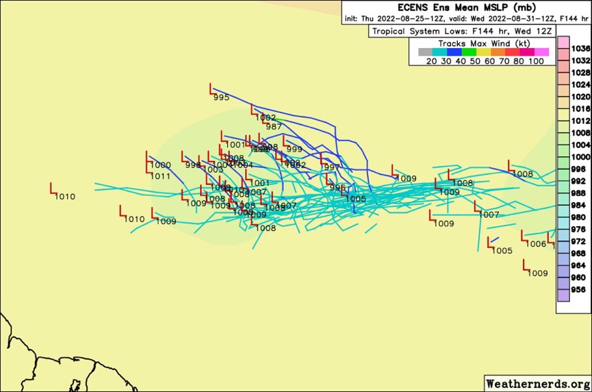
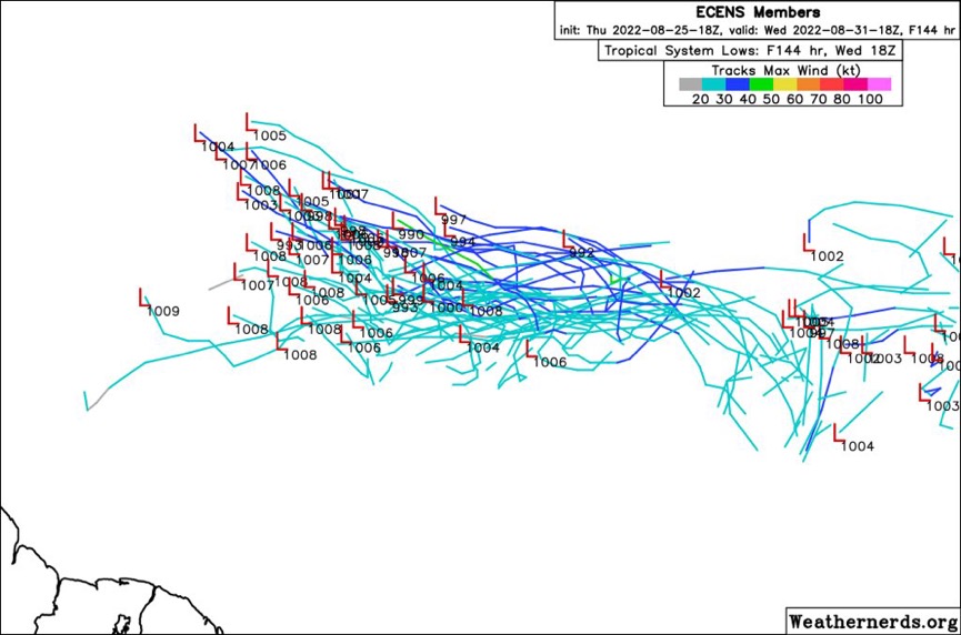
Comparing 144hrs from the eps 12z vs 18z. Looks like an uptick
0 likes
-
SFLcane
- S2K Supporter
- Posts: 10281
- Age: 48
- Joined: Sat Jun 05, 2010 1:44 pm
- Location: Lake Worth Florida
Re: Tropical Wave Near the Cabo Verde Islands
Iceresistance wrote:This could be a problem down the road if it breaks the Monsoon Trough. (I'm saying "if" because it could get retrograded back into the larger system at the African Coast.)
Dry air (and/or SAL) is limited ahead of it.
https://s4.gifyu.com/images/g16split.jpg
https://s4.gifyu.com/images/g16split.jpg
Might be outflow already? (Look to the far right)
https://s4.gifyu.com/images/wg8wvir.gif
https://s4.gifyu.com/images/wg8wvir.gif
Impressive convection with a lot of lightning within it. (Is there a circulation with it as well?)
https://s4.gifyu.com/images/53431668.gif
https://s4.gifyu.com/images/53431668.gif
Upper divergence holy cow!
0 likes
-
Hurricaneman

- Category 5
- Posts: 7404
- Age: 45
- Joined: Tue Aug 31, 2004 3:24 pm
- Location: central florida
Re: Tropical Wave Near the Cabo Verde Islands
I believe the SW lobe will win out, the NE lobe is fighting dry air a I do believe SAL will get that one while the vorticity with the SW one will increase with little to no dry air to inhibit it
1 likes
-
Iceresistance
- Category 5
- Posts: 9608
- Age: 22
- Joined: Sat Oct 10, 2020 9:45 am
- Location: Tecumseh, OK/Norman, OK
Re: Tropical Wave Near the Cabo Verde Islands
SFLcane wrote:Iceresistance wrote:This could be a problem down the road if it breaks the Monsoon Trough. (I'm saying "if" because it could get retrograded back into the larger system at the African Coast.)
Dry air (and/or SAL) is limited ahead of it.
https://s4.gifyu.com/images/g16split.jpg
https://s4.gifyu.com/images/g16split.jpg
Might be outflow already? (Look to the far right)
https://s4.gifyu.com/images/wg8wvir.gif
https://s4.gifyu.com/images/wg8wvir.gif
Impressive convection with a lot of lightning within it. (Is there a circulation with it as well?)
https://s4.gifyu.com/images/53431668.gif
https://s4.gifyu.com/images/53431668.gif
Upper divergence holy cow!
I was thinking of the same thing too, this could be a troublemaker down the road if it keeps going like this. And it's basically Midnight where this system is located! The strong convection appears to be nonstop in the past few hours.
0 likes
Bill 2015 & Beta 2020
Winter 2020-2021
All observations are in Tecumseh, OK unless otherwise noted.
Winter posts are focused mainly for Oklahoma & Texas.
Take any of my forecasts with a grain of salt, refer to the NWS, SPC, and NHC for official information
Never say Never with weather! Because ANYTHING is possible!
Winter 2020-2021
All observations are in Tecumseh, OK unless otherwise noted.
Winter posts are focused mainly for Oklahoma & Texas.
Take any of my forecasts with a grain of salt, refer to the NWS, SPC, and NHC for official information
Never say Never with weather! Because ANYTHING is possible!