Wave emerging Africa: (Is Invest 91L)

This is the general tropical discussion area. Anyone can take their shot at predicting a storms path.

Moderator: S2k Moderators

Forum rules

The posts in this forum are NOT official forecasts and should not be used as such. They are just the opinion of the poster and may or may not be backed by sound meteorological data. They are NOT endorsed by any professional institution or STORM2K. For official information, please refer to products from the National Hurricane Center and National Weather Service.

Help Support Storm2K
Message
Author
User avatar
cycloneye
Admin
Admin
Posts: 145362
Age: 68
Joined: Thu Oct 10, 2002 10:54 am
Location: San Juan, Puerto Rico

Re:

#81 Postby cycloneye » Fri Sep 06, 2013 8:15 pm

HURAKAN wrote:I'll believe the models when I see it. My level of enthusiasm is at an all-time low at this point!!


+1
0 likes   
Visit the Caribbean-Central America Weather Thread where you can find at first post web cams,radars
and observations from Caribbean basin members Click Here

User avatar
HURAKAN
Professional-Met
Professional-Met
Posts: 46086
Age: 38
Joined: Thu May 20, 2004 4:34 pm
Location: Key West, FL
Contact:

#82 Postby HURAKAN » Fri Sep 06, 2013 8:27 pm

Image

latest infrared
0 likes   

User avatar
gatorcane
S2K Supporter
S2K Supporter
Posts: 23691
Age: 47
Joined: Sun Mar 13, 2005 3:54 pm
Location: Boca Raton, FL

Re: Re:

#83 Postby gatorcane » Fri Sep 06, 2013 8:36 pm

Gustywind wrote:
gatorcane wrote:Development chances certainly high for this invest which is just about ready to move off the African continent. Will it become our first hurricane of the 2013 Atlantic season? Certainly looks like it will make a run for it...very nice moisture envelope for this wave, and a big burst of convection should help it get going:
The posts in this forum are NOT official forecast and should not be used as such. They are just the opinion of the poster and may or may not be backed by sound meteorological data. They are NOT endorsed by any professional institution or storm2k.org. For official information, please refer to the NHC and NWS products.

Why not Gatorcane...?! things should take off a bit now as we're in the peak now :lol:
Given your analysis, what elements could hindering the development of this twave, if any? Your thoughts are as usual welcomed :). What could we do if Gatorcane was not on this board often? :)

Thanks Gustywind! :P Regarding inhibiting factors, what Wxman57 said about the mid-level dry air and also the fact the models tend to recurve this relatively quickly after it rolls off Africa which, if happens, would give it less time over warm water and less time to take advantage of a moist environment around the Cape Verde islands.
0 likes   

User avatar
Gustywind
Category 5
Category 5
Posts: 12334
Joined: Mon Sep 03, 2007 7:29 am
Location: Baie-Mahault, GUADELOUPE

Re: Re:

#84 Postby Gustywind » Fri Sep 06, 2013 8:50 pm

gatorcane wrote:
Gustywind wrote:
gatorcane wrote:Development chances certainly high for this invest which is just about ready to move off the African continent. Will it become our first hurricane of the 2013 Atlantic season? Certainly looks like it will make a run for it...very nice moisture envelope for this wave, and a big burst of convection should help it get going:
The posts in this forum are NOT official forecast and should not be used as such. They are just the opinion of the poster and may or may not be backed by sound meteorological data. They are NOT endorsed by any professional institution or storm2k.org. For official information, please refer to the NHC and NWS products.

Why not Gatorcane...?! things should take off a bit now as we're in the peak now :lol:
Given your analysis, what elements could hindering the development of this twave, if any? Your thoughts are as usual welcomed :). What could we do if Gatorcane was not on this board often? :)

Thanks Gustywind! :P Regarding inhibiting factors, what Wxman57 said about the mid-level dry air and also the fact the models tend to recurve this relatively quickly after it rolls off Africa which, if happens, would give it less time over warm water and less time to take advantage of a moist environment around the Cape Verde islands.

Thanks :) seems pretty objective statements IMO :D, agree with that. We will have a better idea during the next couple of days, but that's a great for now.
0 likes   

User avatar
Gustywind
Category 5
Category 5
Posts: 12334
Joined: Mon Sep 03, 2007 7:29 am
Location: Baie-Mahault, GUADELOUPE

#85 Postby Gustywind » Fri Sep 06, 2013 8:54 pm

Hey Ouragans, what do you think about this feature? Any thoughts about? :)
0 likes   

hurricanes1234
Category 5
Category 5
Posts: 2907
Joined: Sat Jul 28, 2012 6:19 pm
Location: Trinidad and Tobago

Re: Wave emerging Africa: 10% - 70%

#86 Postby hurricanes1234 » Fri Sep 06, 2013 10:38 pm

I wonder what's the likelihood of this system pulling an Igor...well, of course on a much smaller scale....

The posts in this forum are NOT official forecast and should not be used as such. They are just the opinion of the poster and may or may not be backed by sound meteorological data. They are NOT endorsed by any professional institution or storm2k.org. For official information, please refer to the NHC and NWS products.
0 likes   
PLEASE NOTE: With the exception of information from weather agencies that I may copy and paste here, my posts will NEVER be official, since I am NOT a meteorologist. They are solely my amateur opinion, and may or may not be accurate. Therefore, please DO NOT use them as official details, particularly when making important decisions. Thank you.

TheStormExpert

#87 Postby TheStormExpert » Fri Sep 06, 2013 10:45 pm

According to the graphics on this web page shear is overall about normal through the Atlantic basin.

http://rammb.cira.colostate.edu/projects/gparm/atlantic_00-24.asp
0 likes   

User avatar
Hammy
Category 5
Category 5
Posts: 5849
Age: 41
Joined: Fri May 25, 2012 5:25 pm
Contact:

#88 Postby Hammy » Sat Sep 07, 2013 1:05 am

0 likes   
The above post is not official and should not be used as such. It is the opinion of the poster and may or may not be backed by sound meteorological data. It is not endorsed by any professional institution or storm2k.org. For official information, please refer to the NHC and NWS products.

User avatar
cycloneye
Admin
Admin
Posts: 145362
Age: 68
Joined: Thu Oct 10, 2002 10:54 am
Location: San Juan, Puerto Rico

Re: Wave emerging Africa: 20% - 80%

#89 Postby cycloneye » Sat Sep 07, 2013 6:48 am

Up to 20%-80%

A TROPICAL WAVE OVER WESTERN AFRICA IS EXPECTED TO MOVE OVER THE FAR
EASTERN ATLANTIC OCEAN ON SUNDAY...AND CONDITIONS APPEAR FAVORABLE
FOR DEVELOPMENT AFTER THAT TIME. THIS SYSTEM HAS A LOW CHANCE...20
PERCENT...OF BECOMING A TROPICAL CYCLONE DURING THE NEXT 48
HOURS...BUT A HIGH CHANCE...80 PERCENT...OF BECOMING A TROPICAL
CYCLONE DURING THE NEXT 5 DAYS. THIS DISTURBANCE IS EXPECTED TO
MOVE WESTWARD AT AROUND 10 MPH NEAR THE CAPE VERDE ISLANDS IN THE
NEXT COUPLE OF DAYS AND THEN WEST-NORTHWESTWARD OVER THE OPEN
EASTERN ATLANTIC.

0 likes   
Visit the Caribbean-Central America Weather Thread where you can find at first post web cams,radars
and observations from Caribbean basin members Click Here

hurricanes1234
Category 5
Category 5
Posts: 2907
Joined: Sat Jul 28, 2012 6:19 pm
Location: Trinidad and Tobago

Re: Wave emerging Africa: 20% - 80%

#90 Postby hurricanes1234 » Sat Sep 07, 2013 6:55 am

Are the models back to showing a hurricane, or did they drop hurricane strength for good?
0 likes   
PLEASE NOTE: With the exception of information from weather agencies that I may copy and paste here, my posts will NEVER be official, since I am NOT a meteorologist. They are solely my amateur opinion, and may or may not be accurate. Therefore, please DO NOT use them as official details, particularly when making important decisions. Thank you.

User avatar
gatorcane
S2K Supporter
S2K Supporter
Posts: 23691
Age: 47
Joined: Sun Mar 13, 2005 3:54 pm
Location: Boca Raton, FL

#91 Postby gatorcane » Sat Sep 07, 2013 7:11 am

GFS and ECMWF continue to be very bullish on development. Has a decent chance of becoming this season's first hurricane.
0 likes   

User avatar
HURAKAN
Professional-Met
Professional-Met
Posts: 46086
Age: 38
Joined: Thu May 20, 2004 4:34 pm
Location: Key West, FL
Contact:

#92 Postby HURAKAN » Sat Sep 07, 2013 7:14 am

lets see if it doesn't dry up after oceanfall ... would be nice to have a system that lasts more than 24 hours!
0 likes   

ninel conde

#93 Postby ninel conde » Sat Sep 07, 2013 7:17 am

it has dried up some since last night. i want to break the record.
0 likes   

User avatar
wxman57
Moderator-Pro Met
Moderator-Pro Met
Posts: 22979
Age: 67
Joined: Sat Jun 21, 2003 8:06 pm
Location: Houston, TX (southwest)

Re: Wave emerging Africa: 20% - 80%

#94 Postby wxman57 » Sat Sep 07, 2013 7:18 am

hurricanes1234 wrote:Are the models back to showing a hurricane, or did they drop hurricane strength for good?


Euro keeps the pressure above 1000mb, indicating moderate TS. GFS has a hurricane striking the Azores in 2 weeks. Don't care what the Canadian says. No threat to the Caribbean or the U.S.
0 likes   

ninel conde

Re: Wave emerging Africa: 20% - 80%

#95 Postby ninel conde » Sat Sep 07, 2013 7:27 am

wxman57 wrote:
hurricanes1234 wrote:Are the models back to showing a hurricane, or did they drop hurricane strength for good?


Euro keeps the pressure above 1000mb, indicating moderate TS. GFS has a hurricane striking the Azores in 2 weeks. Don't care what the Canadian says. No threat to the Caribbean or the U.S.


2weeks? a tropical system wandering around the east atlantic will block any other wave. thats it for the CV season.
0 likes   

tolakram
Admin
Admin
Posts: 20010
Age: 62
Joined: Sun Aug 27, 2006 8:23 pm
Location: Florence, KY (name is Mark)

Re: Wave emerging Africa: 20% - 80%

#96 Postby tolakram » Sat Sep 07, 2013 7:39 am

ninel conde wrote:
wxman57 wrote:
hurricanes1234 wrote:Are the models back to showing a hurricane, or did they drop hurricane strength for good?


Euro keeps the pressure above 1000mb, indicating moderate TS. GFS has a hurricane striking the Azores in 2 weeks. Don't care what the Canadian says. No threat to the Caribbean or the U.S.


2weeks? a tropical system wandering around the east atlantic will block any other wave. thats it for the CV season.

Where in the world do you get these ideas?
0 likes   
M a r k
- - - - -
Join us in chat: Storm2K Chatroom Invite. Android and IOS apps also available.

The posts in this forum are NOT official forecasts and should not be used as such. Posts are NOT endorsed by any professional institution or STORM2K.org. For official information and forecasts, please refer to NHC and NWS products.

hurricanes1234
Category 5
Category 5
Posts: 2907
Joined: Sat Jul 28, 2012 6:19 pm
Location: Trinidad and Tobago

Re: Wave emerging Africa: 20% - 80%

#97 Postby hurricanes1234 » Sat Sep 07, 2013 8:19 am

It does look a little dried up. :(
0 likes   
PLEASE NOTE: With the exception of information from weather agencies that I may copy and paste here, my posts will NEVER be official, since I am NOT a meteorologist. They are solely my amateur opinion, and may or may not be accurate. Therefore, please DO NOT use them as official details, particularly when making important decisions. Thank you.

User avatar
NDG
S2K Supporter
S2K Supporter
Posts: 15446
Joined: Sun Jul 09, 2006 10:14 pm
Location: Orlando, FL

Re: Wave emerging Africa: 20% - 80%

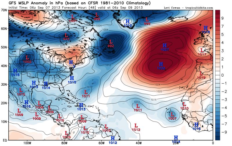
#98 Postby NDG » Sat Sep 07, 2013 8:33 am

My thinking that with such a strong surface high over the Azores for this time of the year during the next few days that this tropical wave is not going to do much strengthwise, I doubt that this could become our first hurricane, lots of stable air over the eastern Atlantic with such a strong surface high.

Image
0 likes   

Zanthe
Tropical Storm
Tropical Storm
Posts: 149
Age: 30
Joined: Sat May 26, 2012 9:26 pm
Location: New Castle, PA

Re: Wave emerging Africa: 20% - 80%

#99 Postby Zanthe » Sat Sep 07, 2013 10:54 am

ninel conde wrote:
wxman57 wrote:
hurricanes1234 wrote:Are the models back to showing a hurricane, or did they drop hurricane strength for good?


Euro keeps the pressure above 1000mb, indicating moderate TS. GFS has a hurricane striking the Azores in 2 weeks. Don't care what the Canadian says. No threat to the Caribbean or the U.S.


2weeks? a tropical system wandering around the east atlantic will block any other wave. thats it for the CV season.


That's just not true.
0 likes   
I'm no expert, everything I say should be taken with a large amount of salt. I could easily be very, very wrong.
~Zanthe Go Coyotes~

TheStormExpert

#100 Postby TheStormExpert » Sat Sep 07, 2013 11:08 am

Does anyone have an idea when this could be tagged an Invest now that the 48hr. development chances are at 20%?
0 likes   


Return to “Talkin' Tropics”

Who is online

Users browsing this forum: caneman, cheezyWXguy, Google Adsense [Bot] and 33 guests