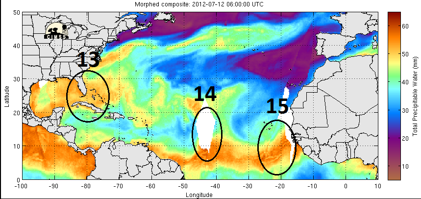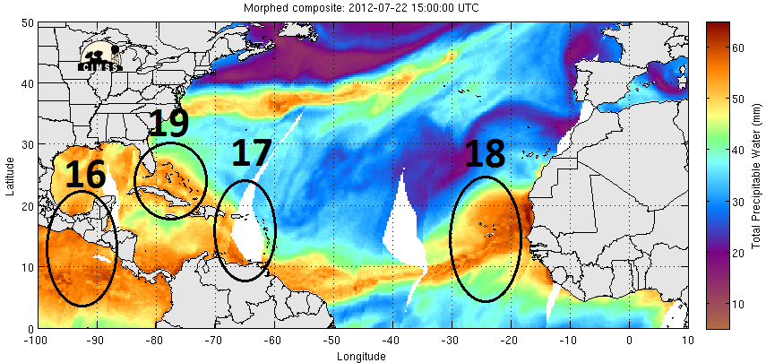
2012 Tropical Waves
Moderator: S2k Moderators
Forum rules
The posts in this forum are NOT official forecasts and should not be used as such. They are just the opinion of the poster and may or may not be backed by sound meteorological data. They are NOT endorsed by any professional institution or STORM2K. For official information, please refer to products from the National Hurricane Center and National Weather Service.
- StormTracker
- S2K Supporter

- Posts: 2909
- Age: 59
- Joined: Thu Jun 29, 2006 6:06 am
- Location: Quail Heights(Redlands), FL.
Re: 2012 Tropical Waves
Apparently this one didn't get the memo either(it's too early)! Here comes another one!


0 likes
Something's wrong when you regret, things that haven't happened yet!
Re: 2012 Tropical Waves
StormTracker wrote:Apparently this one didn't get the memo either(it's too early)! Here comes another one!
I believe that this is not "out of the ordinary" for seasons where there is a Pacific Transition in progress ....
0 likes
- Kingarabian
- S2K Supporter

- Posts: 16383
- Joined: Sat Aug 08, 2009 3:06 am
- Location: Honolulu, Hawaii
- cycloneye
- Admin

- Posts: 149769
- Age: 69
- Joined: Thu Oct 10, 2002 10:54 am
- Location: San Juan, Puerto Rico
Re: 2012 Tropical Waves
Predict Team starts the hunting,tracking and depth analysis of Tropical Waves
Hey peeps,there is great news to report as the predict team has begun they hunting and in depth analysis of all the Tropical Waves that from now will be out there in the Tropical Atlantic and inside Africa.
http://www.met.nps.edu/~mtmontgo/storms2012.html
http://www.met.nps.edu/~mtmontgo/storms2012/P01L.html
0 likes
Visit the Caribbean-Central America Weather Thread where you can find at first post web cams,radars
and observations from Caribbean basin members Click Here
and observations from Caribbean basin members Click Here
Re:
CrazyC83 wrote:I don't see Cape Verde doing much this year in the Atlantic. Too much dry air out there given the developing El Nino.
SAL is present most years (especially in July), El Nino or no El Nino.
0 likes
-
leanne_uk
- Tropical Storm

- Posts: 214
- Age: 43
- Joined: Fri Sep 04, 2009 4:38 pm
- Location: Loughborough countryside, Leicestershire, UK
Re: 2012 Tropical Waves
The next wave Is just about to exit the African coast. Lets see what if anything it can do once over water....
It does seem pretty large at the minute but as we all know that means nothing once it is over the Atlantic
It does seem pretty large at the minute but as we all know that means nothing once it is over the Atlantic
0 likes
- cycloneye
- Admin

- Posts: 149769
- Age: 69
- Joined: Thu Oct 10, 2002 10:54 am
- Location: San Juan, Puerto Rico
Re: 2012 Tropical Waves
New Tropical Wave is introduced close to African Coast at the 12z TAFB Surface Analysis.


0 likes
Visit the Caribbean-Central America Weather Thread where you can find at first post web cams,radars
and observations from Caribbean basin members Click Here
and observations from Caribbean basin members Click Here
-
mzcocoapuf
- Tropical Wave

- Posts: 9
- Joined: Sun Nov 08, 2009 11:45 am
Re: 2012 Tropical Waves
And back to zero on the ITCZ.
The African waves appear to be working up to rotation but lack the moisture or favorable conditions ahead in the Atlantic.
The African waves appear to be working up to rotation but lack the moisture or favorable conditions ahead in the Atlantic.
0 likes
Re: 2012 Tropical Waves
TROPICAL WAVE MOVES WEST OF CAPE VERDE ISLANDS ANALYZED FROM
21N24W TO A 1014 MB LOW NEAR 13N30W MOVING W AT ABOUT 10 KT. THE
LOW CENTER IS JUST A FEW MILES N OF THE MONSOON TROUGH. WAVE
REMAINS ALONG THE LEADING EDGE OF A SURGE OF DEEP LAYER MOISTURE
AS DEPICTED ON TOTAL PRECIPITABLE WATER IMAGERY. HOWEVER...ANY
DEEP CONVECTION IS CURRENTLY ASSOCIATED TO THE MONSOON TROUGH.
0 likes
Who is online
Users browsing this forum: cycloneye, hurricanes1234 and 152 guests


