2023 Indicators (SST, SAL, MSLP, Wind shear, Steering, Instability) and Day 16+ Models
Moderator: S2k Moderators
Forum rules

The posts in this forum are NOT official forecasts and should not be used as such. They are just the opinion of the poster and may or may not be backed by sound meteorological data. They are NOT endorsed by any professional institution or STORM2K. For official information, please refer to products from the National Hurricane Center and National Weather Service.
-
Blown Away

- S2K Supporter

- Posts: 10253
- Joined: Wed May 26, 2004 6:17 am
Re: 2023 Indicators (SST, SAL, MSLP, Wind shear, Steering, Instability) and Day 16+ Models
El Niño Augusts have produced legendary canes. The extreme SST’s may fuel a hyper active August before the El Niño shear shuts down September on. JMHO
1 likes
Hurricane Eye Experience: David 79, Irene 99, Frances 04, Jeanne 04, Wilma 05… Hurricane Brush Experience: Andrew 92, Erin 95, Floyd 99, Matthew 16, Irma 17, Ian 22, Nicole 22…
-
Category5Kaiju

- Category 5

- Posts: 4347
- Joined: Thu Dec 24, 2020 12:45 pm
- Location: Seattle during the summer, Phoenix during the winter
Re: 2023 Indicators (SST, SAL, MSLP, Wind shear, Steering, Instability) and Day 16+ Models
Blown Away wrote:El Niño Augusts have produced legendary canes. The extreme SST’s may fuel a hyper active August before the El Niño shear shuts down September on. JMHO
Indeed.
1899:

1951:

1965:

1969:

All of these were in El Nino years and formed in the month of August.
5 likes
Unless explicitly stated, all information in my posts is based on my own opinions and observations. Tropical storms and hurricanes can be extremely dangerous. Refer to an accredited weather research agency or meteorologist if you need to make serious decisions regarding an approaching storm.
-
weeniepatrol

- Category 5
- Posts: 1345
- Joined: Sat Aug 22, 2020 5:30 pm
- Location: WA State
Re: 2023 Indicators (SST, SAL, MSLP, Wind shear, Steering, Instability) and Day 16+ Models
In terms of actual temperatures the mdr has only cooled about 0.2C. It’s just that since climo is quick warming this time of year, this cooling manifests on anomaly charts as a far larger decrease.
3 likes

Re: 2023 Indicators (SST, SAL, MSLP, Wind shear, Steering, Instability) and Day 16+ Models
I believe June 2023 has set a record for the highest ACE in any June, but if Cindy regenerates like pretty much every model is saying, then this season could further crush that record. ~10 ACE is on the table if Cindy becomes a Cat 1 in the subtropics.
7 likes
Irene '11 Sandy '12 Hermine '16 5/15/2018 Derecho Fay '20 Isaias '20 Elsa '21 Henri '21 Ida '21
I am only a meteorology enthusiast who knows a decent amount about tropical cyclones. Look to the professional mets, the NHC, or your local weather office for the best information.
I am only a meteorology enthusiast who knows a decent amount about tropical cyclones. Look to the professional mets, the NHC, or your local weather office for the best information.
Re: 2023 Indicators (SST, SAL, MSLP, Wind shear, Steering, Instability) and Day 16+ Models
With the likely help from Bret and Cindy taking energy out of the very warm ocean, much of the MDR has cooled off nicely from an anomaly perspective over the last week though that may not be the primary reason.
Last edited by LarryWx on Sun Jun 25, 2023 6:02 am, edited 2 times in total.
1 likes
Personal Forecast Disclaimer:
The posts in this forum are NOT official forecasts and should not be used as such. They are just the opinion of the poster and may or may not be backed by sound meteorological data. They are NOT endorsed by any professional institution or storm2k.org. For official information, please refer to the NHC and NWS products.
The posts in this forum are NOT official forecasts and should not be used as such. They are just the opinion of the poster and may or may not be backed by sound meteorological data. They are NOT endorsed by any professional institution or storm2k.org. For official information, please refer to the NHC and NWS products.
Re: 2023 Indicators (SST, SAL, MSLP, Wind shear, Steering, Instability) and Day 16+ Models
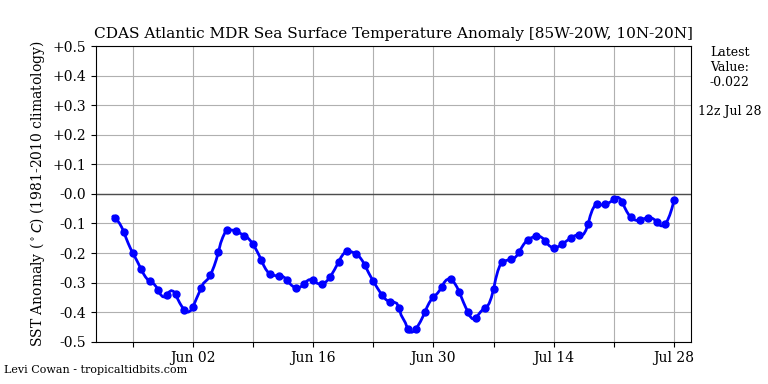
More on the above post. The CDAS based MDR has cooled from whatever causes (combo of increased SAL off of record lows and Bret/Cindy?) from an anomaly of +1.2 C on June 13th to only +0.6 C on June 25th:
https://www.tropicaltidbits.com/analysi ... drssta.png
This matters quite a bit, especially with the strong El Niño developing as it may allow it to take more control and not have as much interference from keeping things from getting out of hand in the Atlantic.
https://www.tropicaltidbits.com/analysi ... drssta.png
This matters quite a bit, especially with the strong El Niño developing as it may allow it to take more control and not have as much interference from keeping things from getting out of hand in the Atlantic.
1 likes
Personal Forecast Disclaimer:
The posts in this forum are NOT official forecasts and should not be used as such. They are just the opinion of the poster and may or may not be backed by sound meteorological data. They are NOT endorsed by any professional institution or storm2k.org. For official information, please refer to the NHC and NWS products.
The posts in this forum are NOT official forecasts and should not be used as such. They are just the opinion of the poster and may or may not be backed by sound meteorological data. They are NOT endorsed by any professional institution or storm2k.org. For official information, please refer to the NHC and NWS products.
Re: 2023 Indicators (SST, SAL, MSLP, Wind shear, Steering, Instability) and Day 16+ Models
LarryWx wrote:More on the above post. The CDAS based MDR has cooled from whatever causes (combo of increased SAL off of record lows and Bret/Cindy?) from an anomaly of +1.2 C on June 13th to only +0.6 C on June 25th:
https://www.tropicaltidbits.com/analysi ... drssta.png
This matters quite a bit, especially with the strong El Niño developing as it may allow it to take more control and not have as much interference from keeping things from getting out of hand in the Atlantic.
CDAS has a low bias. The better CRW and OISS SSTA maps on cyclonicwx (the latter of which was corrected last year) shows that the MDR has cooled to a still insane +1.0-1.2 C. A strong +AMO look still remains, and there’s still a ton of warmth in the Canary Current and NE Atlantic that could end up working its way back south. If those warm pools noticeably cool/return to normal over the next few weeks, then the odds of the +ENSO winning dramatically increase.
6 likes
Irene '11 Sandy '12 Hermine '16 5/15/2018 Derecho Fay '20 Isaias '20 Elsa '21 Henri '21 Ida '21
I am only a meteorology enthusiast who knows a decent amount about tropical cyclones. Look to the professional mets, the NHC, or your local weather office for the best information.
I am only a meteorology enthusiast who knows a decent amount about tropical cyclones. Look to the professional mets, the NHC, or your local weather office for the best information.
-
Category5Kaiju
- Category 5
- Posts: 4347
- Joined: Thu Dec 24, 2020 12:45 pm
- Location: Seattle during the summer, Phoenix during the winter
Re: 2023 Indicators (SST, SAL, MSLP, Wind shear, Steering, Instability) and Day 16+ Models
The insanely warm sst anomalies in the Atlantic might be one very convincing factor pointing to a non-traditional El Niño season in the Atlantic.
However, it is important to note that between the -PMM/-PDO in the EPAC and a potent WAM expected over Africa, there are some other key factors that point toward the possibility of the Atlantic performing better than would be expected even in the face of an El Niño.
However, it is important to note that between the -PMM/-PDO in the EPAC and a potent WAM expected over Africa, there are some other key factors that point toward the possibility of the Atlantic performing better than would be expected even in the face of an El Niño.
1 likes
Unless explicitly stated, all information in my posts is based on my own opinions and observations. Tropical storms and hurricanes can be extremely dangerous. Refer to an accredited weather research agency or meteorologist if you need to make serious decisions regarding an approaching storm.
-
jconsor
- Professional-Met

- Posts: 582
- Joined: Mon Jun 30, 2008 9:31 pm
- Location: Jerusalem, Israel
- Contact:
Re: 2023 Indicators (SST, SAL, MSLP, Wind shear, Steering, Instability) and Day 16+ Models
I strongly advise caution when using CDAS SST charts to gauge trends in the tropical Atlanitc. It is known to have a substantial cold bias, especially during times of SAL surges which block its ability to properly assess SSTs.
OISST agrees with CDAS on a 0.35 to 0.4C drop in MDR SSTs between Jun 11 and 17, but shows little change (at most a 0.05C drop) from Jun 17 to 24. On the other hand, CDAS shows a further 0.35 to 0.4C drop from Jun 17 to 24.


You can see in these OISST anomaly images that the notable drop occurred between Jun 11 and 17. From Jun 17 to 23 there was little change overall, some slight cooling E of 40W and some slight warming from the central tropical Atlantic into the E and NW Caribbean.


The fact that CDAS is not listed in the UCAR repository of SST datasets, and is almost never referenced in academic literature about water temperatures (based on a quick search I did on Google Scholar) should also be red flags.
https://climatedataguide.ucar.edu/clima ... ison-table
OISST agrees with CDAS on a 0.35 to 0.4C drop in MDR SSTs between Jun 11 and 17, but shows little change (at most a 0.05C drop) from Jun 17 to 24. On the other hand, CDAS shows a further 0.35 to 0.4C drop from Jun 17 to 24.
You can see in these OISST anomaly images that the notable drop occurred between Jun 11 and 17. From Jun 17 to 23 there was little change overall, some slight cooling E of 40W and some slight warming from the central tropical Atlantic into the E and NW Caribbean.
The fact that CDAS is not listed in the UCAR repository of SST datasets, and is almost never referenced in academic literature about water temperatures (based on a quick search I did on Google Scholar) should also be red flags.
https://climatedataguide.ucar.edu/clima ... ison-table
LarryWx wrote:More on the above post. The CDAS based MDR has cooled from whatever causes (combo of increased SAL off of record lows and Bret/Cindy?) from an anomaly of +1.2 C on June 13th to only +0.6 C on June 25th:
https://www.tropicaltidbits.com/analysi ... drssta.png
This matters quite a bit, especially with the strong El Niño developing as it may allow it to take more control and not have as much interference from keeping things from getting out of hand in the Atlantic.
Last edited by jconsor on Sun Jun 25, 2023 9:44 am, edited 1 time in total.
10 likes
Re: 2023 Indicators (SST, SAL, MSLP, Wind shear, Steering, Instability) and Day 16+ Models
Category5Kaiju wrote:The insanely warm sst anomalies in the Atlantic might be one very convincing factor pointing to a non-traditional El Niño season in the Atlantic.
However, it is important to note that between the -PMM/-PDO in the EPAC and a potent WAM expected over Africa, there are some other key factors that point toward the possibility of the Atlantic performing better than would be expected even in the face of an El Niño.
We all know it has already been much more active than normal for June in the MDR with a record high level of activity due largely to record warm MDR anomalies/record low SAL for June. But the big question now is whether or not that will continue if El Niño strengthens substantially the rest of the summer. The MDR anomalies have cooled 0.4 to 0.45 to ~+1.15 over the last two weeks per CRW and OISST. Still very warm but a loss of ~25% of the anomaly. Let's see where those anomalies go between now and the start of climo peak season.
2 likes
Personal Forecast Disclaimer:
The posts in this forum are NOT official forecasts and should not be used as such. They are just the opinion of the poster and may or may not be backed by sound meteorological data. They are NOT endorsed by any professional institution or storm2k.org. For official information, please refer to the NHC and NWS products.
The posts in this forum are NOT official forecasts and should not be used as such. They are just the opinion of the poster and may or may not be backed by sound meteorological data. They are NOT endorsed by any professional institution or storm2k.org. For official information, please refer to the NHC and NWS products.
Re: 2023 Indicators (SST, SAL, MSLP, Wind shear, Steering, Instability) and Day 16+ Models
jconsor wrote:I strongly advise caution when using CDAS SST charts to gauge trends in the tropical Atlanitc. It is known to have a substantial cold bias, especially during times of SAL surges which block its ability to properly assess SSTs.
OISST agrees with CDAS on a 0.35 to 0.4C drop in MDR SSTs between Jun 11 and 17, but shows little change (at most a 0.05C drop) from Jun 17 to 24. On the other hand, CDAS shows a further 0.35 to 0.4C drop from Jun 17 to 24.
https://i.ibb.co/HGXdmYx/OISST-MDR-SST-graph.png
https://i.ibb.co/Jz40LhF/CDAS-MDR-SST-graph.png
You can see in these OISST anomaly images that the notable drop occurred between Jun 11 and 17. From Jun 17 to 23 there was little change overall, some slight cooling E of 40W and some slight warming from the central tropical Atlantic into the E and NW Caribbean.
https://i.ibb.co/tqwHbFJ/oisst-anom-1d-tropatl-2023061100.png
https://i.ibb.co/MMqrxg4/oisst-anom-1d-tropatl-2023061700.png
https://i.ibb.co/Sv6vC33/oisst-anom-1d-tropatl-2023062300.png
The fact that CDAS is not listed in the UCAR repository of SST datasets, and is almost never referenced in academic literature about water temperatures (based on a quick search I did on Google Scholar) should also be red flags.
https://climatedataguide.ucar.edu/clima ... ison-tableLarryWx wrote:More on the above post. The CDAS based MDR has cooled from whatever causes (combo of increased SAL off of record lows and Bret/Cindy?) from an anomaly of +1.2 C on June 13th to only +0.6 C on June 25th:
https://www.tropicaltidbits.com/analysi ... drssta.png
This matters quite a bit, especially with the strong El Niño developing as it may allow it to take more control and not have as much interference from keeping things from getting out of hand in the Atlantic.
For the MDR SST anomalies, I'll emphasize CRW and OISST from now on (via cyclonicwx) and will deemphasize CDAS. I look at all three for the Nino regions.
2 likes
Personal Forecast Disclaimer:
The posts in this forum are NOT official forecasts and should not be used as such. They are just the opinion of the poster and may or may not be backed by sound meteorological data. They are NOT endorsed by any professional institution or storm2k.org. For official information, please refer to the NHC and NWS products.
The posts in this forum are NOT official forecasts and should not be used as such. They are just the opinion of the poster and may or may not be backed by sound meteorological data. They are NOT endorsed by any professional institution or storm2k.org. For official information, please refer to the NHC and NWS products.
-
Category5Kaiju
- Category 5
- Posts: 4347
- Joined: Thu Dec 24, 2020 12:45 pm
- Location: Seattle during the summer, Phoenix during the winter
Re: 2023 Indicators (SST, SAL, MSLP, Wind shear, Steering, Instability) and Day 16+ Models
Just realized Danny Morris recently sent out this Tweet about the expected activity in the EPAC. I don't want to speculate about the future too much at this point in time. However, I can't help but start to wonder if we're about to see a reverse of last year's setup, with the Atlantic overperforming and the EPAC underperforming in spite of an ENSO state traditionally favorable for the EPAC and detrimental for the Atlantic.
https://twitter.com/dmorris9661/status/1672933952175185921
https://twitter.com/dmorris9661/status/1672933952175185921
3 likes
Unless explicitly stated, all information in my posts is based on my own opinions and observations. Tropical storms and hurricanes can be extremely dangerous. Refer to an accredited weather research agency or meteorologist if you need to make serious decisions regarding an approaching storm.
Re: 2023 Indicators (SST, SAL, MSLP, Wind shear, Steering, Instability) and Day 16+ Models
For years with Niño 3.4 of +1.0+ during JJA, here are the # of June/July geneses on record:
2015: 1/1
1997: 2/3
1987: 0/0
1972: 1/0
1965: 1/0
1957: 2/0
1905: 0/0
1902: 2/0
1877: 0/0
Average # of June/July geneses on record: 1.00/0.44.
Does this imply the chances are good for a quieter July vs June in terms of # of storms? (I'm not talking about strength). Any opinions?
Edit: Yes, I know that four of these years were before satellites.
0 likes
Personal Forecast Disclaimer:
The posts in this forum are NOT official forecasts and should not be used as such. They are just the opinion of the poster and may or may not be backed by sound meteorological data. They are NOT endorsed by any professional institution or storm2k.org. For official information, please refer to the NHC and NWS products.
The posts in this forum are NOT official forecasts and should not be used as such. They are just the opinion of the poster and may or may not be backed by sound meteorological data. They are NOT endorsed by any professional institution or storm2k.org. For official information, please refer to the NHC and NWS products.
-
cycloneye

- Admin

- Posts: 149746
- Age: 69
- Joined: Thu Oct 10, 2002 10:54 am
- Location: San Juan, Puerto Rico
Re: 2023 Indicators (SST, SAL, MSLP, Wind shear, Steering, Instability) and Day 16+ Models
3 likes
Visit the Caribbean-Central America Weather Thread where you can find at first post web cams,radars
and observations from Caribbean basin members Click Here
and observations from Caribbean basin members Click Here
-
cycloneye
- Admin
- Posts: 149746
- Age: 69
- Joined: Thu Oct 10, 2002 10:54 am
- Location: San Juan, Puerto Rico
Re: 2023 Indicators (SST, SAL, MSLP, Wind shear, Steering, Instability) and Day 16+ Models
Looks like El NIño slowly catching on to affect the Atlantic.
https://twitter.com/AndyHazelton/status/1673426604616454144
https://twitter.com/AndyHazelton/status/1673426604616454144
2 likes
Visit the Caribbean-Central America Weather Thread where you can find at first post web cams,radars
and observations from Caribbean basin members Click Here
and observations from Caribbean basin members Click Here

Re: 2023 Indicators (SST, SAL, MSLP, Wind shear, Steering, Instability) and Day 16+ Models
Webb continues to think the atmospheric response isn't typical of an El Nino so far.
https://twitter.com/webberweather/status/1673485132572033024
https://twitter.com/webberweather/status/1673485132572033024
2 likes
TC naming lists: retirements and intensity
Most aggressive Advisory #1's in North Atlantic (cr. kevin for starting the list)
Most aggressive Advisory #1's in North Atlantic (cr. kevin for starting the list)
-
toad strangler

- S2K Supporter
- Posts: 4546
- Joined: Sun Jul 28, 2013 3:09 pm
- Location: Earth
- Contact:
Re: 2023 Indicators (SST, SAL, MSLP, Wind shear, Steering, Instability) and Day 16+ Models
Brett and Cindy gave the Atlantic an ACE kickstart. Does the line stay ahead of the median all the way through? A tough task it will be as we all know with our newly crowned El Nino. All of those lines on the graph represent North Atlantic Basin seasons starting in 1966.

3 likes
My Weather Station
https://www.wunderground.com/dashboard/pws/KFLPORTS603
https://www.wunderground.com/dashboard/pws/KFLPORTS603
Re: 2023 Indicators (SST, SAL, MSLP, Wind shear, Steering, Instability) and Day 16+ Models
In the MDR, OISST SSTa cooled rather notably from +1.19 on 6/26 to +1.123 today. CRW cooled slightly from +1.15 to +1.128. The strongly cold biased/less reliable CDAS cooled over the last 2 days from 0.594 on 6/25 to 0.440 today. The CDAS is so cold biased that I'm now only paying attention to the changes and not the actual per se.
0 likes
Personal Forecast Disclaimer:
The posts in this forum are NOT official forecasts and should not be used as such. They are just the opinion of the poster and may or may not be backed by sound meteorological data. They are NOT endorsed by any professional institution or storm2k.org. For official information, please refer to the NHC and NWS products.
The posts in this forum are NOT official forecasts and should not be used as such. They are just the opinion of the poster and may or may not be backed by sound meteorological data. They are NOT endorsed by any professional institution or storm2k.org. For official information, please refer to the NHC and NWS products.
-
Category5Kaiju
- Category 5
- Posts: 4347
- Joined: Thu Dec 24, 2020 12:45 pm
- Location: Seattle during the summer, Phoenix during the winter
Re: 2023 Indicators (SST, SAL, MSLP, Wind shear, Steering, Instability) and Day 16+ Models
With the Atlantic catching a break from activity and the EPAC getting more active, it looks like wx Twitter has become a battlefield between those who believe that this Atlantic season is going to defy norms with the insane +AMO and -PDO look in the Pacific and those who believe the El Nino is going to single-handedly shut down the Atlantic.
Gonna be an interesting several months to watch for sure
Gonna be an interesting several months to watch for sure
6 likes
Unless explicitly stated, all information in my posts is based on my own opinions and observations. Tropical storms and hurricanes can be extremely dangerous. Refer to an accredited weather research agency or meteorologist if you need to make serious decisions regarding an approaching storm.
-
toad strangler
- S2K Supporter
- Posts: 4546
- Joined: Sun Jul 28, 2013 3:09 pm
- Location: Earth
- Contact:
Re: 2023 Indicators (SST, SAL, MSLP, Wind shear, Steering, Instability) and Day 16+ Models
I like reading Michael Lowry's content and today he is talking about how the MDR has cooled and will continue to do so for a bit but the SAL that has come on board is rather underwhelming for the time of year. The subtropical high won't just come roaring back so the future trend he believes is for elevated SST's to stick around.


2 likes
My Weather Station
https://www.wunderground.com/dashboard/pws/KFLPORTS603
https://www.wunderground.com/dashboard/pws/KFLPORTS603
Who is online
Users browsing this forum: No registered users and 244 guests