Low pressure developing over the western Caribbean Sea (Is Invest 97L)

This is the general tropical discussion area. Anyone can take their shot at predicting a storms path.

Moderator: S2k Moderators

Forum rules

The posts in this forum are NOT official forecasts and should not be used as such. They are just the opinion of the poster and may or may not be backed by sound meteorological data. They are NOT endorsed by any professional institution or STORM2K. For official information, please refer to products from the National Hurricane Center and National Weather Service.

Help Support Storm2K
Message
Author
User avatar
ThomasW
Tropical Depression
Tropical Depression
Posts: 78
Age: 44
Joined: Thu May 19, 2022 10:59 am
Contact:

Re: Area of low pressure to develop over the western Caribbean sea (0/50)

#641 Postby ThomasW » Fri Sep 20, 2024 3:07 pm

cheezyWXguy wrote:
gatorcane wrote:12Z NAVGEM, think it is a bit too far to the left but yikes, CAT 4:

https://i.postimg.cc/9fZ5278S/navgem-mslp-uv850-watl-fh96-180.gif

That might be the strongest storm I’ve ever seen the NAVGEM model. Good thing it’s terrible. On a similar note, a recent run of the Korean model has a cat5 a bit south of there. No idea if that model is any good but seems too extreme either way.

If you remember MINDULLE 2021, the NAVGEM bottomed that one out all the way down at 880!
1 likes   

caneman
Category 5
Category 5
Posts: 1447
Joined: Fri Sep 05, 2014 5:44 am
Location: Clearwater Beach, Fl

Re: Area of low pressure to develop over the western Caribbean sea (0/50)

#642 Postby caneman » Fri Sep 20, 2024 3:14 pm

CourierPR wrote:The latest satellite loop appears to show something forming in the SW Caribbean. If it comes together faster than forecast, would future track be affected?


I've been saying that since this morning. It's sustained all day and looking rather impressive on visible. Really surprised no one is talking about it. As i recall If it formed earlier, I believe it would lean more toward west Florida but we shall see. I believe this is ready to go from Orange to Cherry.
2 likes   

User avatar
WaveBreaking
Category 2
Category 2
Posts: 578
Joined: Sun Jun 30, 2024 11:33 am
Location: US

Re: Area of low pressure to develop over the western Caribbean sea (0/50)

#643 Postby WaveBreaking » Fri Sep 20, 2024 3:19 pm

Frank P wrote:
mcheer23 wrote:
cheezyWXguy wrote:That might be the strongest storm I’ve ever seen the NAVGEM model. Good thing it’s terrible. On a similar note, a recent run of the Korean model has a cat5 a bit south of there. No idea if that model is any good but seems too extreme either way.


KMA has back to back Cat 5 runs.

I have searched the web for the KMA to no avail, do you have a link please? thanks


The KMA is on weathermodels.com, but you need a subscription to use the site. Not sure if it’s on any other site tho.
1 likes   
I am NOT a professional meteorologist, so take all of my posts with a grain of salt. My opinions are mine and mine alone.

User avatar
Teban54
Category 5
Category 5
Posts: 3206
Joined: Sat May 19, 2018 1:19 pm

Re: Area of low pressure to develop over the western Caribbean sea (0/50)

#644 Postby Teban54 » Fri Sep 20, 2024 3:31 pm

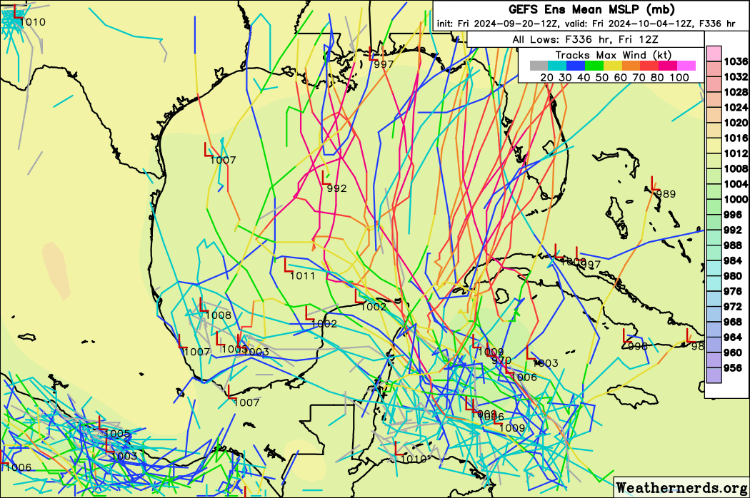
This has to be one of the most bullish GEFS runs so far, right?

Image
4 likes   

Stormlover70
Tropical Storm
Tropical Storm
Posts: 175
Age: 55
Joined: Fri Jun 21, 2024 5:31 am
Location: New port richey

Re: Area of low pressure to develop over the western Caribbean sea (0/50)

#645 Postby Stormlover70 » Fri Sep 20, 2024 3:31 pm

Stratton23 wrote:Frank P

https://www.cpc.ncep.noaa.gov/products/ ... ntours.png

Hope this link works
LA to Tampa
0 likes   

User avatar
HurricaneBelle
S2K Supporter
S2K Supporter
Posts: 1179
Joined: Sun Aug 27, 2006 6:12 pm
Location: Clearwater, FL

Re: Area of low pressure to develop over the western Caribbean sea (0/50)

#646 Postby HurricaneBelle » Fri Sep 20, 2024 3:33 pm

Teban54 wrote:This has to be one of the most bullish GEFS runs so far, right?

https://i.postimg.cc/mgv23Qx3/gefs-2024-09-20-12-Z-336-32-19-255-81-14-526-287-703-MSLP-Surface-tracks-lows.png


This is why it's ridiculous to say anyone's in the clear or "dodged a bullet" on a storm that hasn't even formed yet.
7 likes   

User avatar
WaveBreaking
Category 2
Category 2
Posts: 578
Joined: Sun Jun 30, 2024 11:33 am
Location: US

Re: Area of low pressure to develop over the western Caribbean sea (0/50)

#647 Postby WaveBreaking » Fri Sep 20, 2024 3:34 pm

caneman wrote:
CourierPR wrote:The latest satellite loop appears to show something forming in the SW Caribbean. If it comes together faster than forecast, would future track be affected?


I've been saying that since this morning. It's sustained all day and looking rather impressive on visible. Really surprised no one is talking about it. As i recall If it formed earlier, I believe it would lean more toward west Florida but we shall see. I believe this is ready to go from Orange to Cherry.


Ditto. The CAG is definitely starting to set up.

Image
3 likes   

I am NOT a professional meteorologist, so take all of my posts with a grain of salt. My opinions are mine and mine alone.

User avatar
StPeteMike
Category 2
Category 2
Posts: 631
Joined: Thu Jun 07, 2018 11:26 pm

Re: Area of low pressure to develop over the western Caribbean sea (0/50)

#648 Postby StPeteMike » Fri Sep 20, 2024 3:37 pm

Teban54 wrote:This has to be one of the most bullish GEFS runs so far, right?

https://i.postimg.cc/mgv23Qx3/gefs-2024-09-20-12-Z-336-32-19-255-81-14-526-287-703-MSLP-Surface-tracks-lows.png

Yeah, this doesn’t scream “Florida Shield”…
4 likes   
The above post is not official and should not be used as such. It is the opinion of the poster and may or may not be backed by sound meteorological data. It is not endorsed by any professional institution or storm2k.org. For official information, please refer to the NHC and NWS products.

DunedinDave
Tropical Storm
Tropical Storm
Posts: 227
Joined: Fri Aug 25, 2023 10:31 am

Re: Area of low pressure to develop over the western Caribbean sea (0/50)

#649 Postby DunedinDave » Fri Sep 20, 2024 3:40 pm

Even if it forms early, I don’t think it’s gonna move much. If anything, this could be a Wilma where it sits and spins near the Yucatán until something pulls it a certain direction. I still think by Wednesday we’re still talking about a system near the Yucatán channel. The earlier it forms, the stronger it’ll be.

In other words…let’s hope it’s not getting its act together yet. Or else this could spell trouble.
4 likes   

User avatar
Nimbus
Category 5
Category 5
Posts: 5300
Joined: Mon Jul 19, 2004 10:54 am

Re: Area of low pressure to develop over the western Caribbean sea (0/50)

#650 Postby Nimbus » Fri Sep 20, 2024 3:42 pm

ThomasW wrote:
cheezyWXguy wrote:
gatorcane wrote:12Z NAVGEM, think it is a bit too far to the left but yikes, CAT 4:

https://i.postimg.cc/9fZ5278S/navgem-mslp-uv850-watl-fh96-180.gif

That might be the strongest storm I’ve ever seen the NAVGEM model. Good thing it’s terrible. On a similar note, a recent run of the Korean model has a cat5 a bit south of there. No idea if that model is any good but seems too extreme either way.

If you remember MINDULLE 2021, the NAVGEM bottomed that one out all the way down at 880!


You can see the steering high currently centered over Texas.
The NAVGEM must be migrating the high NE slower than the GFS?
GFS and Euro show the steering high pressure northeast of the gulf in 180 hours.

https://www.tropicaltidbits.com/sat/sat ... uct=wv_mid
1 likes   

User avatar
jfk08c
S2K Supporter
S2K Supporter
Posts: 204
Joined: Mon Jun 11, 2018 4:36 pm
Location: Lakeland, FL

Re: Area of low pressure to develop over the western Caribbean sea (0/50)

#651 Postby jfk08c » Fri Sep 20, 2024 3:44 pm

StPeteMike wrote:
Teban54 wrote:This has to be one of the most bullish GEFS runs so far, right?

https://i.postimg.cc/mgv23Qx3/gefs-2024-09-20-12-Z-336-32-19-255-81-14-526-287-703-MSLP-Surface-tracks-lows.png

Yeah, this doesn’t scream “Florida Shield”…


I feel like it's been repeated multiple times that the best advice now is to look at ensembles instead of operational runs and look for trends.

At this point, without genesis, operationals are basically like throwing a dart blindfolded at a board. Yet, some people treat them as gospel. Not saying there isn't a chance any of the operationals will verify, but with this many questions marks revolving setup, it's better to look at the bigger picture
7 likes   

User avatar
Category5Kaiju
Category 5
Category 5
Posts: 4097
Joined: Thu Dec 24, 2020 12:45 pm
Location: Seattle

Re: Area of low pressure to develop over the western Caribbean sea (0/50)

#652 Postby Category5Kaiju » Fri Sep 20, 2024 3:45 pm

Teban54 wrote:This has to be one of the most bullish GEFS runs so far, right?

https://i.postimg.cc/mgv23Qx3/gefs-2024-09-20-12-Z-336-32-19-255-81-14-526-287-703-MSLP-Surface-tracks-lows.png


And as early as this morning, there was talk of there being a possibility of nothing forming at all or only a very weak system happening.

CAG genesis is a nightmare, I will admit. :lol:

But when models continuously advertise something like this happening (as they did with Michael, for example), it’s rather likely that we’re going to get something after all.
5 likes   
Unless explicitly stated, all info in my posts is based on my own opinions and observations. Tropical storms and hurricanes can be extremely dangerous. Do not think you can beat Mother Nature. Refer to an accredited weather research agency or meteorologist if you need to make serious decisions regarding an approaching storm.

psyclone
S2K Supporter
S2K Supporter
Posts: 4762
Joined: Wed Aug 24, 2005 9:04 pm
Location: palm harbor fl

Re: Area of low pressure to develop over the western Caribbean sea (0/50)

#653 Postby psyclone » Fri Sep 20, 2024 3:49 pm

Energy is definitely bundling down in the southwest Caribbean as convection blossoms...finally. the chance that something forms is most certainly high and rising. But who knows what or where it goes. CAG SWAG is a brutally slow process. And no one dodges an unfired bullet. That's not how it works. We have to be patient even when we don't want to be..
3 likes   

User avatar
StPeteMike
Category 2
Category 2
Posts: 631
Joined: Thu Jun 07, 2018 11:26 pm

Re: Area of low pressure to develop over the western Caribbean sea (0/50)

#654 Postby StPeteMike » Fri Sep 20, 2024 4:05 pm

jfk08c wrote:
StPeteMike wrote:
Teban54 wrote:This has to be one of the most bullish GEFS runs so far, right?

https://i.postimg.cc/mgv23Qx3/gefs-2024-09-20-12-Z-336-32-19-255-81-14-526-287-703-MSLP-Surface-tracks-lows.png

Yeah, this doesn’t scream “Florida Shield”…


I feel like it's been repeated multiple times that the best advice now is to look at ensembles instead of operational runs and look for trends.

At this point, without genesis, operationals are basically like throwing a dart blindfolded at a board. Yet, some people treat them as gospel. Not saying there isn't a chance any of the operationals will verify, but with this many questions marks revolving setup, it's better to look at the bigger picture

For sure! Not saying Florida is the prime target, just saying we need to squash the “we dodged another one” talk.

Understand nobody wants a storm, especially when one can become a major, but we have many lurkers on these pages that rely on us for our insight and for the Mets on here expertise. At this point, all of the Gulf has a percentage chance of seeing a storm in a week. Not going to say what portion of the Gulf has the higher percentage because we need a LLC.
2 likes   
The above post is not official and should not be used as such. It is the opinion of the poster and may or may not be backed by sound meteorological data. It is not endorsed by any professional institution or storm2k.org. For official information, please refer to the NHC and NWS products.

User avatar
cheezyWXguy
Category 5
Category 5
Posts: 6108
Joined: Mon Feb 13, 2006 12:29 am
Location: Dallas, TX

Re: Area of low pressure to develop over the western Caribbean sea (0/50)

#655 Postby cheezyWXguy » Fri Sep 20, 2024 4:16 pm

mcheer23 wrote:
cheezyWXguy wrote:
gatorcane wrote:12Z NAVGEM, think it is a bit too far to the left but yikes, CAT 4:

https://i.postimg.cc/9fZ5278S/navgem-mslp-uv850-watl-fh96-180.gif

That might be the strongest storm I’ve ever seen the NAVGEM model. Good thing it’s terrible. On a similar note, a recent run of the Korean model has a cat5 a bit south of there. No idea if that model is any good but seems too extreme either way.


KMA has back to back Cat 5 runs.

Is it any good? I assume it’s overly bullish on intensity, considering one of its runs has it at like 885mb…
0 likes   

User avatar
toad strangler
S2K Supporter
S2K Supporter
Posts: 4543
Joined: Sun Jul 28, 2013 3:09 pm
Location: Earth
Contact:

Re: Area of low pressure to develop over the western Caribbean sea (0/50)

#656 Postby toad strangler » Fri Sep 20, 2024 4:17 pm

Lifted from a Weather Tiger update…
Image
2 likes   

xironman
S2K Supporter
S2K Supporter
Posts: 2522
Joined: Sun Jun 10, 2007 4:53 pm
Location: NoVA

Re: Area of low pressure to develop over the western Caribbean sea (0/50)

#657 Postby xironman » Fri Sep 20, 2024 4:21 pm

Nice little twist coming off the coast of Honduras. You can see the low level clouds heading south rather than west to the north of it

Image
Last edited by xironman on Fri Sep 20, 2024 4:25 pm, edited 1 time in total.
6 likes   

User avatar
kevin
Category 5
Category 5
Posts: 2586
Age: 26
Joined: Wed Aug 28, 2019 4:35 am

Re: Area of low pressure to develop over the western Caribbean sea (0/50)

#658 Postby kevin » Fri Sep 20, 2024 4:24 pm

If convection maintains for a while this might become an invest soner than expected.
4 likes   

User avatar
ConvergenceZone
Category 5
Category 5
Posts: 5194
Joined: Fri Jul 29, 2005 1:40 am
Location: Northern California

Re: Area of low pressure to develop over the western Caribbean sea (0/50)

#659 Postby ConvergenceZone » Fri Sep 20, 2024 4:33 pm

toad strangler wrote:Lifted from a Weather Tiger update…
https://i.ibb.co/ZmrG91t/IMG-2395.png


That map shows just how rare it is to get a storm in Texas this time of year.
1 likes   

DunedinDave
Tropical Storm
Tropical Storm
Posts: 227
Joined: Fri Aug 25, 2023 10:31 am

Re: Area of low pressure to develop over the western Caribbean sea (0/50)

#660 Postby DunedinDave » Fri Sep 20, 2024 4:41 pm

kevin wrote:If convection maintains for a while this might become an invest soner than expected.


Yeah but not sure if it will hold overnight. Wait and see.
0 likes   


Return to “Talkin' Tropics”

Who is online

Users browsing this forum: No registered users and 33 guests