2015 EPAC Season
Moderator: S2k Moderators
Forum rules

The posts in this forum are NOT official forecasts and should not be used as such. They are just the opinion of the poster and may or may not be backed by sound meteorological data. They are NOT endorsed by any professional institution or STORM2K. For official information, please refer to products from the National Hurricane Center and National Weather Service.
-
Yellow Evan

- Professional-Met

- Posts: 16211
- Age: 27
- Joined: Fri Jul 15, 2011 12:48 pm
- Location: Henderson, Nevada/Honolulu, HI
- Contact:
-
Kingarabian

- S2K Supporter

- Posts: 16294
- Joined: Sat Aug 08, 2009 3:06 am
- Location: Honolulu, Hawaii
-
Yellow Evan
- Professional-Met
- Posts: 16211
- Age: 27
- Joined: Fri Jul 15, 2011 12:48 pm
- Location: Henderson, Nevada/Honolulu, HI
- Contact:
Re:
Kingarabian wrote:GFS has 94E in the long range as well. CFS forecast may not be too off right now. Doing this all without a Kelvin Wave.
We have a Kelvin Wave forming over the EPAC in a few days.
0 likes
-
Kingarabian
- S2K Supporter
- Posts: 16294
- Joined: Sat Aug 08, 2009 3:06 am
- Location: Honolulu, Hawaii

-
srainhoutx

- S2K Supporter
- Posts: 6919
- Age: 68
- Joined: Sun Jan 14, 2007 11:34 am
- Location: Haywood County, NC
- Contact:
Re: 2015 EPAC Season
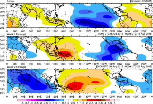
A couple of things are working in favor of tropical development across the Eastern and Central Pacific. As Yellow Evan mentioned, a moderate CCKW is favorable as well as a wet phase of the MJO which is moving slowly E across the Pacific Ocean. I would not be surprise to see possibly two additional tropical cyclones develop during the mid to late August timeframe generally moving W to WNW.
0 likes
Carla/Alicia/Jerry(In The Eye)/Michelle/Charley/Ivan/Dennis/Katrina/Rita/Wilma/Ike/Harvey
Member: National Weather Association
Wx Infinity Forums
http://wxinfinity.com/index.php
Facebook.com/WeatherInfinity
Twitter @WeatherInfinity
Member: National Weather Association
Wx Infinity Forums
http://wxinfinity.com/index.php
Facebook.com/WeatherInfinity
Twitter @WeatherInfinity
-
CaliforniaResident
- Tropical Storm

- Posts: 215
- Joined: Fri Feb 21, 2014 1:47 pm
Re: 2015 EPAC Season
srainhoutx wrote:A couple of things are working in favor of tropical development across the Eastern and Central Pacific. As Yellow Evan mentioned, a moderate CCKW is favorable as well as a wet phase of the MJO which is moving slowly E across the Pacific Ocean. I would not be surprise to see possibly two additional tropical cyclones develop during the mid to late August timeframe generally moving W to WNW.
Do you forsee any hurricanes taking a closer path up the coast of Baja the way Blanca and Dolores did earlier this summer and Norbert and Odile did last September? When will the MJO reach into the far Eastern Pacific?
0 likes
-
Yellow Evan
- Professional-Met
- Posts: 16211
- Age: 27
- Joined: Fri Jul 15, 2011 12:48 pm
- Location: Henderson, Nevada/Honolulu, HI
- Contact:
Re: 2015 EPAC Season
CaliforniaResident wrote:
Do you forsee any hurricanes taking a closer path up the coast of Baja the way Blanca and Dolores did earlier this summer and Norbert and Odile did last September? When will the MJO reach into the far Eastern Pacific?
Yes, probs in a few weeks per most long range guidance. MJO won't be in the EPAC for a while, but we'll have a bunch of CCKW's.
0 likes
-
cycloneye

- Admin

- Posts: 148722
- Age: 69
- Joined: Thu Oct 10, 2002 10:54 am
- Location: San Juan, Puerto Rico
Re: 2015 EPAC Season
An Odile type hurricane is not out of the question for later in the season for Cabo San Lucas,BCS,Sinaloa area.
0 likes
Visit the Caribbean-Central America Weather Thread where you can find at first post web cams,radars
and observations from Caribbean basin members Click Here
and observations from Caribbean basin members Click Here
-
Yellow Evan
- Professional-Met
- Posts: 16211
- Age: 27
- Joined: Fri Jul 15, 2011 12:48 pm
- Location: Henderson, Nevada/Honolulu, HI
- Contact:

-
Kingarabian
- S2K Supporter
- Posts: 16294
- Joined: Sat Aug 08, 2009 3:06 am
- Location: Honolulu, Hawaii
-
Yellow Evan
- Professional-Met
- Posts: 16211
- Age: 27
- Joined: Fri Jul 15, 2011 12:48 pm
- Location: Henderson, Nevada/Honolulu, HI
- Contact:
Re:
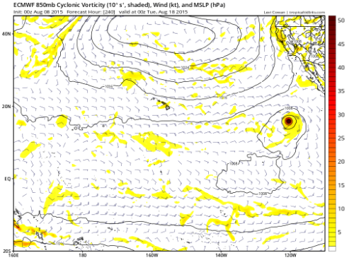
Kingarabian wrote:Things to note:
We've yet to see the classical basin crosser moving from East to West.
So far we had storms forming from West and south and crossing quickly into the CPAC.
So far shear seems too high for Iselle-esque East to West crosser.
0 likes
-
Kingarabian
- S2K Supporter
- Posts: 16294
- Joined: Sat Aug 08, 2009 3:06 am
- Location: Honolulu, Hawaii
Re: Re:
Yellow Evan wrote:Kingarabian wrote:Things to note:
We've yet to see the classical basin crosser moving from East to West.
So far we had storms forming from West and south and crossing quickly into the CPAC.
So far shear seems too high for Iselle-esque East to West crosser.
We might have our Iselle 10 days out:

GFS of course doesn't show this.
0 likes
RIP Kobe Bryant
-
cycloneye
- Admin
- Posts: 148722
- Age: 69
- Joined: Thu Oct 10, 2002 10:54 am
- Location: San Juan, Puerto Rico
Re: 2015 EPAC Season
An area of low pressure is forecast to form a few hundred miles
south of Mexico in a few days. Environmental conditions should
support some development of this system by the weekend while it
moves west-northwestward at about 15 mph.
* Formation chance through 48 hours...low...near 0 percent
* Formation chance through 5 days...low...30 percent
south of Mexico in a few days. Environmental conditions should
support some development of this system by the weekend while it
moves west-northwestward at about 15 mph.
* Formation chance through 48 hours...low...near 0 percent
* Formation chance through 5 days...low...30 percent
0 likes
Visit the Caribbean-Central America Weather Thread where you can find at first post web cams,radars
and observations from Caribbean basin members Click Here
and observations from Caribbean basin members Click Here
-
Yellow Evan
- Professional-Met
- Posts: 16211
- Age: 27
- Joined: Fri Jul 15, 2011 12:48 pm
- Location: Henderson, Nevada/Honolulu, HI
- Contact:

-
Yellow Evan
- Professional-Met
- Posts: 16211
- Age: 27
- Joined: Fri Jul 15, 2011 12:48 pm
- Location: Henderson, Nevada/Honolulu, HI
- Contact:
An area of low pressure is forecast to form a few hundred miles
south of Mexico in a few days. Environmental conditions should
support gradual development of this system by the weekend while it
moves west-northwestward at about 15 mph.
* Formation chance through 48 hours...low...near 0 percent
* Formation chance through 5 days...medium...50 percent
south of Mexico in a few days. Environmental conditions should
support gradual development of this system by the weekend while it
moves west-northwestward at about 15 mph.
* Formation chance through 48 hours...low...near 0 percent
* Formation chance through 5 days...medium...50 percent
0 likes
-
Yellow Evan
- Professional-Met
- Posts: 16211
- Age: 27
- Joined: Fri Jul 15, 2011 12:48 pm
- Location: Henderson, Nevada/Honolulu, HI
- Contact:
2. A tropical wave located south of the coast of Guatemala and El
Salvador is producing an area of disorganized cloudiness and
showers. An area of low pressure is forecast to form in association
with this wave a few hundred miles south-southwest of the coast of
Mexico later this week. Environmental conditions should support
gradual development of the low by the weekend while it moves
west-northwestward at about 15 mph.
* Formation chance through 48 hours...low...10 percent
* Formation chance through 5 days...high...70 percent
0 likes
-
Kingarabian
- S2K Supporter
- Posts: 16294
- Joined: Sat Aug 08, 2009 3:06 am
- Location: Honolulu, Hawaii

-
Yellow Evan
- Professional-Met
- Posts: 16211
- Age: 27
- Joined: Fri Jul 15, 2011 12:48 pm
- Location: Henderson, Nevada/Honolulu, HI
- Contact:
GFS has been in weird mode for quite some time. I'm still pretty keen on more activity due to the El Nino base state, which favors activity in both the WPAC and EPAC. Keep in mind that tow years with similary strong El Nino forcing (1997 and 1983) weren't that active in August, and it seems this kind of season comes alive in September.
It hasn't even been that dead. We have 11 named storms, ACE of near 100, and 4 Cat 4's. I've accepted the fact that this is no 2014, but we could still get some respectable numbers by the season's end.
It hasn't even been that dead. We have 11 named storms, ACE of near 100, and 4 Cat 4's. I've accepted the fact that this is no 2014, but we could still get some respectable numbers by the season's end.
0 likes
-
Yellow Evan
- Professional-Met
- Posts: 16211
- Age: 27
- Joined: Fri Jul 15, 2011 12:48 pm
- Location: Henderson, Nevada/Honolulu, HI
- Contact:
A tropical wave located south of the southeastern coast of Mexico
is producing disorganized cloudiness and showers. An area of low
pressure is forecast to form in association with this wave within a
couple of days a few hundred miles south-southwest of the coast of
Mexico. Environmental conditions should support development later
this week, and the system is very likely to become a tropical
cyclone by Sunday while it moves west-northwestward at about 15 mph.
* Formation chance through 48 hours...low...20 percent
* Formation chance through 5 days...high...90 percent
0 likes
Who is online
Users browsing this forum: No registered users and 83 guests