2025 Global Model Runs Discussion (Out thru day 16)
Moderator: S2k Moderators
Forum rules

The posts in this forum are NOT official forecasts and should not be used as such. They are just the opinion of the poster and may or may not be backed by sound meteorological data. They are NOT endorsed by any professional institution or STORM2K. For official information, please refer to products from the National Hurricane Center and National Weather Service.
-
Stratton23
- Category 5

- Posts: 3578
- Joined: Fri Jul 21, 2023 10:59 pm
- Location: Katy, Tx
Re: 2025 Global Model Runs Discussion (Out thru day 16)
I don’t think it stays quiet behind ERIN, a kelvin wave will be moving across the basin which should help to boost the waves behind ERIN, doesnt look insanely busy, but definitely not dead quiet either
1 likes
-
convergencezone2
- Tropical Low

- Posts: 11
- Joined: Tue Jul 29, 2025 4:03 pm
Re: 2025 Global Model Runs Discussion (Out thru day 16)
TomballEd wrote:There be a 98L/Fernand after Erin, which will also almost immediately recurve. Might be another after that. Maybe.
After that, anything would probably be 'home brew'. I see the random systems closer to the US but ensembles usually manage to get a random storm forecast Famous last words but I think the tropics will be quiet the next two weeks
Hoping we do get major hurricane satellite imagery from Erin and any possible MDR storm that may follow in its foot steps.
Even if every single one of these storms coming off Africa does recurve due to weak high pressure, I think we will still get a couple of storms by the end of September / October that will develop in either the Gulf or the Carib that will pose an actual landfall threat.
3 likes
-
TomballEd
- Category 5
- Posts: 1322
- Age: 62
- Joined: Wed Aug 16, 2023 4:52 pm
- Location: Spring/Klein area, not Tomball
Re: 2025 Global Model Runs Discussion (Out thru day 16)
convergencezone2 wrote:TomballEd wrote:There be a 98L/Fernand after Erin, which will also almost immediately recurve. Might be another after that. Maybe.
After that, anything would probably be 'home brew'. I see the random systems closer to the US but ensembles usually manage to get a random storm forecast Famous last words but I think the tropics will be quiet the next two weeks
Hoping we do get major hurricane satellite imagery from Erin and any possible MDR storm that may follow in its foot steps.
Even if every single one of these storms coming off Africa does recurve due to weak high pressure, I think we will still get a couple of storms by the end of September / October that will develop in either the Gulf or the Carib that will pose an actual landfall threat.
I don't doubt that. Late season storms affecting Florida seems to have become very common.
2 likes
-
WeatherBoy2000
- Category 1

- Posts: 463
- Joined: Mon Apr 10, 2023 9:29 am
Re: 2025 Global Model Runs Discussion (Out thru day 16)
The euro weeklies is showing well above normal ace in the short term (largely due to Erin), however, this is predicted to quickly fall off. The first half of September is predicted to be below normal, this is likely due to the mjo becoming unfavorable for the basin by then.
1 likes

Re: 2025 Global Model Runs Discussion (Out thru day 16)
WeatherBoy2000 wrote:The euro weeklies is showing well above normal ace in the short term (largely due to Erin), however, this is predicted to quickly fall off. The first half of September is predicted to be below normal, this is likely due to the mjo becoming unfavorable for the basin by then.
Indeed, the latest Euro Weeklies are showing only 80% of ACE for 9/1-14, a big drop from the progged 400% for 8/18-24 due to Erin to ~1/2 the progged ACE for 8/18-24 (likely MJO related as you said).
But then again, it’s 80% of the very active 2005-24 climo for near peak season. So, even if the 80% were to verify well, that would still mean an active period (even though not to the degree of the Erin week) and would end up way more active than for that period in 2024. Sep 1-14 of 2024 had only ~5-6 ACE, which is a mere <20% of the ~31 ACE avg for 2005-24. Compare that to the EW’s 80% prog, which would be ~25 ACE for Sep 1-14 of 2025 or 4-5 times as high as 2024.
2 likes
Personal Forecast Disclaimer:
The posts in this forum are NOT official forecasts and should not be used as such. They are just the opinion of the poster and may or may not be backed by sound meteorological data. They are NOT endorsed by any professional institution or storm2k.org. For official information, please refer to the NHC and NWS products.
The posts in this forum are NOT official forecasts and should not be used as such. They are just the opinion of the poster and may or may not be backed by sound meteorological data. They are NOT endorsed by any professional institution or storm2k.org. For official information, please refer to the NHC and NWS products.
-
WeatherBoy2000
- Category 1
- Posts: 463
- Joined: Mon Apr 10, 2023 9:29 am
Re: 2025 Global Model Runs Discussion (Out thru day 16)
LarryWx wrote:WeatherBoy2000 wrote:The euro weeklies is showing well above normal ace in the short term (largely due to Erin), however, this is predicted to quickly fall off. The first half of September is predicted to be below normal, this is likely due to the mjo becoming unfavorable for the basin by then.
Indeed, the latest Euro Weeklies are showing only 80% of ACE for 9/1-14, a big drop from the progged 400% for 8/18-24 due to Erin to ~1/2 the ACE for that week (likely MJO related as you said).
But then again, it’s 80% of the very active 2005-24 climo for near peak season. So, even if the 80% were to verify well, that would still mean an active period (even though not to the degree of the Erin week) and would end up way more active than for that period in 2024. Sep 1-14 of 2024 had only ~5-6 ACE, which is a mere <20% of the ~31 ACE avg for 2005-24. Compare that to the EW’s 80% prog, which would be ~25 ACE or 4-5 times as high as 2024.
Interestingly, the weeklies are still predicting above normal storm frequency during this time. We may still see a good amount of short-lived storms and hurricanes, but a lack of anything long-lived. My guess is the mjo will come back around to the Atlantic during the second half of September, which may open the door to more late season CV storms like last year.
3 likes
Re: 2025 Global Model Runs Discussion (Out thru day 16)
WeatherBoy2000 wrote:LarryWx wrote:WeatherBoy2000 wrote:The euro weeklies is showing well above normal ace in the short term (largely due to Erin), however, this is predicted to quickly fall off. The first half of September is predicted to be below normal, this is likely due to the mjo becoming unfavorable for the basin by then.
Indeed, the latest Euro Weeklies are showing only 80% of ACE for 9/1-14, a big drop from the progged 400% for 8/18-24 due to Erin to ~1/2 the ACE for that week (likely MJO related as you said).
But then again, it’s 80% of the very active 2005-24 climo for near peak season. So, even if the 80% were to verify well, that would still mean an active period (even though not to the degree of the Erin week) and would end up way more active than for that period in 2024. Sep 1-14 of 2024 had only ~5-6 ACE, which is a mere <20% of the ~31 ACE avg for 2005-24. Compare that to the EW’s 80% prog, which would be ~25 ACE or 4-5 times as high as 2024.
Interestingly, the weeklies are still predicting above normal storm frequency during this time. We may still see a good amount of short-lived storms and hurricanes, but a lack of anything long-lived. My guess is the mjo will come back around to the Atlantic during the second half of September, which may open the door to more late season CV storms like last year.
Yeah, if the MJO is in phases 8-1-2 then, watch out Conus especially.
2 likes
Personal Forecast Disclaimer:
The posts in this forum are NOT official forecasts and should not be used as such. They are just the opinion of the poster and may or may not be backed by sound meteorological data. They are NOT endorsed by any professional institution or storm2k.org. For official information, please refer to the NHC and NWS products.
The posts in this forum are NOT official forecasts and should not be used as such. They are just the opinion of the poster and may or may not be backed by sound meteorological data. They are NOT endorsed by any professional institution or storm2k.org. For official information, please refer to the NHC and NWS products.
Re: 2025 Global Model Runs Discussion (Out thru day 16)
12Z UK: for several runs has had this after Erin:
NEW TROPICAL CYCLONE FORECAST TO DEVELOP AFTER 156 HOURS
FORECAST POSITION AT T+156 : 15.9N 24.3W
LEAD CENTRAL MAXIMUM WIND
VERIFYING TIME TIME POSITION PRESSURE (MB) SPEED (KNOTS)
-------------- ---- -------- ------------- -------------
0000UTC 20.08.2025 156 15.9N 24.3W 1010 28
1200UTC 20.08.2025 168 15.7N 28.1W 1009 32
FORECAST POSITION AT T+156 : 15.9N 24.3W
LEAD CENTRAL MAXIMUM WIND
VERIFYING TIME TIME POSITION PRESSURE (MB) SPEED (KNOTS)
-------------- ---- -------- ------------- -------------
0000UTC 20.08.2025 156 15.9N 24.3W 1010 28
1200UTC 20.08.2025 168 15.7N 28.1W 1009 32
1 likes
Personal Forecast Disclaimer:
The posts in this forum are NOT official forecasts and should not be used as such. They are just the opinion of the poster and may or may not be backed by sound meteorological data. They are NOT endorsed by any professional institution or storm2k.org. For official information, please refer to the NHC and NWS products.
The posts in this forum are NOT official forecasts and should not be used as such. They are just the opinion of the poster and may or may not be backed by sound meteorological data. They are NOT endorsed by any professional institution or storm2k.org. For official information, please refer to the NHC and NWS products.

Re: 2025 Global Model Runs Discussion (Out thru day 16)
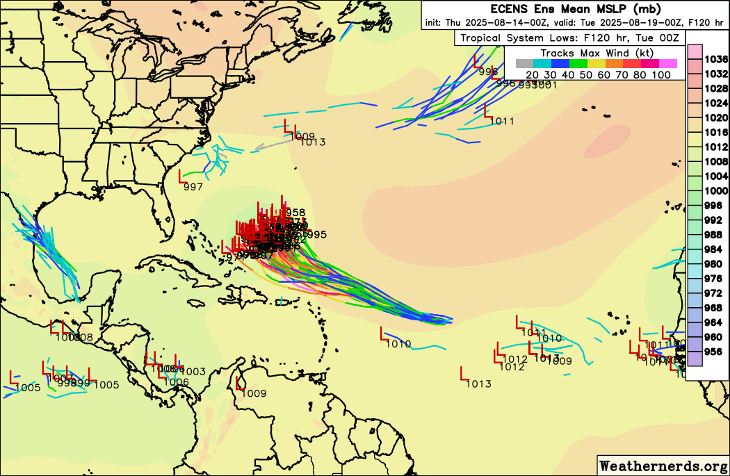
12z Euro after Erin takes a wave through the Caribbean and gets it in the gulf something to keep an eye on in the future
0 likes
Re: 2025 Global Model Runs Discussion (Out thru day 16)
12z Euro ensembles animated to try to show the wave behind erin on here, quite a few wind up in the Bahamas.
2 likes
-
TomballEd
- Category 5
- Posts: 1322
- Age: 62
- Joined: Wed Aug 16, 2023 4:52 pm
- Location: Spring/Klein area, not Tomball
Re: 2025 Global Model Runs Discussion (Out thru day 16)
BobHarlem wrote:12z Euro ensembles animated to try to show the wave behind erin on here, quite a few wind up in the Bahamas.
https://i.postimg.cc/9fRGPksY/64844100.gif
10% of the EPS at hour 360 show something in the Gulf, which is always interesting. 15 days out, I'm curbing my enthusiasm.
0 likes

Re: 2025 Global Model Runs Discussion (Out thru day 16)
If something gets into the Caribbean, it’s probably not gonna end too well for someone. The 12z Euro/EPS has gotten my attention.
2 likes
-
convergencezone2
- Tropical Low
- Posts: 11
- Joined: Tue Jul 29, 2025 4:03 pm
Re: 2025 Global Model Runs Discussion (Out thru day 16)
WeatherBoy2000 wrote:The euro weeklies is showing well above normal ace in the short term (largely due to Erin), however, this is predicted to quickly fall off. The first half of September is predicted to be below normal, this is likely due to the mjo becoming unfavorable for the basin by then.
could mean that this might be one of those back-loaded seasons then.
0 likes
Re: 2025 Global Model Runs Discussion (Out thru day 16)
LarryWx wrote:12Z UK: for several runs has had this after Erin:NEW TROPICAL CYCLONE FORECAST TO DEVELOP AFTER 156 HOURS
FORECAST POSITION AT T+156 : 15.9N 24.3W
LEAD CENTRAL MAXIMUM WIND
VERIFYING TIME TIME POSITION PRESSURE (MB) SPEED (KNOTS)
-------------- ---- -------- ------------- -------------
0000UTC 20.08.2025 156 15.9N 24.3W 1010 28
1200UTC 20.08.2025 168 15.7N 28.1W 1009 32
Followup to above:
0Z UKMET has a similarly placed TD following Erin vs the 12Z run:
NEW TROPICAL CYCLONE FORECAST TO DEVELOP AFTER 156 HOURS
FORECAST POSITION AT T+156 : 15.9N 28.1W
LEAD CENTRAL MAXIMUM WIND
VERIFYING TIME TIME POSITION PRESSURE (MB) SPEED (KNOTS)
-------------- ---- -------- ------------- -------------
1200UTC 20.08.2025 156 15.9N 28.1W 1010 33
0000UTC 21.08.2025 168 15.8N 30.4W 1009 29
FORECAST POSITION AT T+156 : 15.9N 28.1W
LEAD CENTRAL MAXIMUM WIND
VERIFYING TIME TIME POSITION PRESSURE (MB) SPEED (KNOTS)
-------------- ---- -------- ------------- -------------
1200UTC 20.08.2025 156 15.9N 28.1W 1010 33
0000UTC 21.08.2025 168 15.8N 30.4W 1009 29
0 likes
Personal Forecast Disclaimer:
The posts in this forum are NOT official forecasts and should not be used as such. They are just the opinion of the poster and may or may not be backed by sound meteorological data. They are NOT endorsed by any professional institution or storm2k.org. For official information, please refer to the NHC and NWS products.
The posts in this forum are NOT official forecasts and should not be used as such. They are just the opinion of the poster and may or may not be backed by sound meteorological data. They are NOT endorsed by any professional institution or storm2k.org. For official information, please refer to the NHC and NWS products.
-
StormWeather

- Category 1
- Posts: 477
- Joined: Wed Jun 05, 2024 2:34 pm
Re: 2025 Global Model Runs Discussion (Out thru day 16)
convergencezone2 wrote:WeatherBoy2000 wrote:The euro weeklies is showing well above normal ace in the short term (largely due to Erin), however, this is predicted to quickly fall off. The first half of September is predicted to be below normal, this is likely due to the mjo becoming unfavorable for the basin by then.
could mean that this might be one of those back-loaded seasons then.
Well right now we are roughly even with 2024 in NS. Last year and this year were or are at 5 NS.
If we follow this similar trend, I wouldn’t be surprised to see us at Sebastian by early-to-mid-November.
0 likes
Just an average cyclone tracker
The posts in this forum are NOT official forecasts and should not be used as such. They are just the opinion of the poster and may or may not be backed by sound meteorological data. They are NOT endorsed by any professional institution or storm2k.org. For official information, please refer to the NHC and NWS products
The posts in this forum are NOT official forecasts and should not be used as such. They are just the opinion of the poster and may or may not be backed by sound meteorological data. They are NOT endorsed by any professional institution or storm2k.org. For official information, please refer to the NHC and NWS products

Re: 2025 Global Model Runs Discussion (Out thru day 16)
BobHarlem wrote:12z Euro ensembles animated to try to show the wave behind erin on here, quite a few wind up in the Bahamas.
https://i.postimg.cc/9fRGPksY/64844100.gif
0z EPS is slightly more aggressive with this wave, with about 40-50% of the members showing a low. Wide spread from Caribbean to the Bahamas.
This run also shows some support for the following wave, on a much more clear-cut recurve pattern (even earlier than Erin), but pretty weak in both support for development and intensity.
1 likes
TC naming lists: retirements and intensity
Most aggressive Advisory #1's in North Atlantic (cr. kevin for starting the list)
Most aggressive Advisory #1's in North Atlantic (cr. kevin for starting the list)
Re: 2025 Global Model Runs Discussion (Out thru day 16)
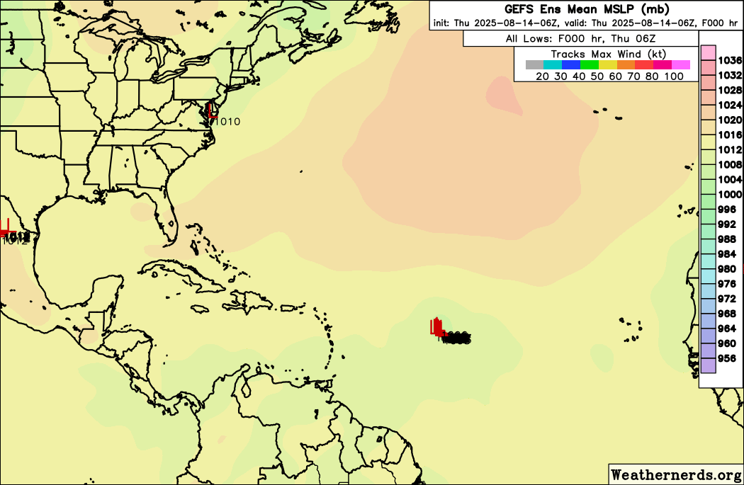
6z GFS Ensembles animated highlighting the wave behind Erin here.
1 likes
-
Hurrilurker

- Category 2

- Posts: 738
- Joined: Mon Jun 09, 2003 3:32 pm
- Location: San Francisco, CA
Re: 2025 Global Model Runs Discussion (Out thru day 16)
Seems the big key is when/if the high over the Atlantic is going to build back in more to the west. Difference between quiet and scary for most of the populated areas (and maybe the opposite for Bermuda).
0 likes
Re: 2025 Global Model Runs Discussion (Out thru day 16)
LarryWx wrote:LarryWx wrote:12Z UK: for several runs has had this after Erin:NEW TROPICAL CYCLONE FORECAST TO DEVELOP AFTER 156 HOURS
FORECAST POSITION AT T+156 : 15.9N 24.3W
LEAD CENTRAL MAXIMUM WIND
VERIFYING TIME TIME POSITION PRESSURE (MB) SPEED (KNOTS)
-------------- ---- -------- ------------- -------------
0000UTC 20.08.2025 156 15.9N 24.3W 1010 28
1200UTC 20.08.2025 168 15.7N 28.1W 1009 32
Followup to above:
0Z UKMET has a similarly placed TD following Erin vs the 12Z run:
NEW TROPICAL CYCLONE FORECAST TO DEVELOP AFTER 156 HOURS
FORECAST POSITION AT T+156 : 15.9N 28.1W
LEAD CENTRAL MAXIMUM WIND
VERIFYING TIME TIME POSITION PRESSURE (MB) SPEED (KNOTS)
-------------- ---- -------- ------------- -------------
1200UTC 20.08.2025 156 15.9N 28.1W 1010 33
0000UTC 21.08.2025 168 15.8N 30.4W 1009 29
Followup: this looks like an AEW preceding the one the last two UKMET runs had with a TD forming 200 miles E of Guadalupe
12Z UKMET
NEW TROPICAL CYCLONE FORECAST TO DEVELOP AFTER 168 HOURS
FORECAST POSITION AT T+168 : 16.4N 58.4W
LEAD CENTRAL MAXIMUM WIND
VERIFYING TIME TIME POSITION PRESSURE (MB) SPEED (KNOTS)
-------------- ---- -------- ------------- -------------
1200UTC 21.08.2025 168 16.4N 58.4W 1009 32
NEW TROPICAL CYCLONE FORECAST TO DEVELOP AFTER 168 HOURS
FORECAST POSITION AT T+168 : 16.4N 58.4W
LEAD CENTRAL MAXIMUM WIND
VERIFYING TIME TIME POSITION PRESSURE (MB) SPEED (KNOTS)
-------------- ---- -------- ------------- -------------
1200UTC 21.08.2025 168 16.4N 58.4W 1009 32
0 likes
Personal Forecast Disclaimer:
The posts in this forum are NOT official forecasts and should not be used as such. They are just the opinion of the poster and may or may not be backed by sound meteorological data. They are NOT endorsed by any professional institution or storm2k.org. For official information, please refer to the NHC and NWS products.
The posts in this forum are NOT official forecasts and should not be used as such. They are just the opinion of the poster and may or may not be backed by sound meteorological data. They are NOT endorsed by any professional institution or storm2k.org. For official information, please refer to the NHC and NWS products.

Re: 2025 Global Model Runs Discussion (Out thru day 16)
18z Happy Hour GFS turns this wave behind Erin into a Cat 3 strike on the Lesser Antilles and Puerto Rico.
2 likes
Irene '11 Sandy '12 Hermine '16 5/15/2018 Derecho Fay '20 Isaias '20 Elsa '21 Henri '21 Ida '21
I am only a meteorology enthusiast who knows a decent amount about tropical cyclones. Look to the professional mets, the NHC, or your local weather office for the best information.
I am only a meteorology enthusiast who knows a decent amount about tropical cyclones. Look to the professional mets, the NHC, or your local weather office for the best information.
Who is online
Users browsing this forum: gib and 164 guests