2025 Indicators: SST's, MSLP, Shear, SAL, Steering, Instability (Day 16+ Climate Models)
Moderator: S2k Moderators
Forum rules

The posts in this forum are NOT official forecasts and should not be used as such. They are just the opinion of the poster and may or may not be backed by sound meteorological data. They are NOT endorsed by any professional institution or STORM2K. For official information, please refer to products from the National Hurricane Center and National Weather Service.
-
TallyTracker
- Category 2

- Posts: 787
- Joined: Thu Oct 11, 2018 2:46 pm
Re: 2025 Indicators: SST's, MSLP, Shear, SAL, Steering, Instability (Day 16+ Climate Models)
We had our first cold front of the year hit the Gulf Coast at the end of August. Our lows dropped to the low-mid 60s. It’s warmed back up so but overall it’s looking and feeling more like a fall pattern here. I noticed too the northern Gulf water temps are now at or slightly below average now. Can’t speak for the whole basin, but the pattern here is more like October than early September.
3 likes
Fran '96, Georges '98, Gordon '00, Gabrielle '01, Charley '04, Frances '04, Jeanne '04, Barry '07, Fay '08, Debby '12, Matthew '16, Emily '17, Irma '17, Michael ‘18, Elsa ‘21, Fred ‘21, Mindy ‘21, Nicole ‘22, Idalia ‘23, Debby ‘24, Helene ‘24

Re: 2025 Indicators: SST's, MSLP, Shear, SAL, Steering, Instability (Day 16+ Climate Models)
we're headed for peak season on 9-10 where we have a 90% historical probability of a named storm in the basin...and this year looks like a 10% year where there is no storm. It's remarkable how dead it is. there's no season cancel posts because it just seems people have moved on. Very odd but after last year...im good with the tranquility.
0 likes

Re: 2025 Indicators: SST's, MSLP, Shear, SAL, Steering, Instability (Day 16+ Climate Models)
Here's my long-standing question about dry air.
When people talk about dry air in general indicator threads like this, the impression is typically: "dry air exists in the MDR = nothing can form, MDR cancelled". Yet, I look at archives of dry air imagery, major hurricanes in the MDR are often right next to pockets of mid-level dry air, which can even be in the dead center of MDR.
The loop below shows, at their peak intensity: Lorenzo 2019, Teddy 2020, Sam 2021, Lee 2023, Beryl 2024, Kirk 2024, and Erin 2025. All were Cat 4/5s in or next to the MDR, and you can see dry pockets (red) next to all of them, often well within the MDR.
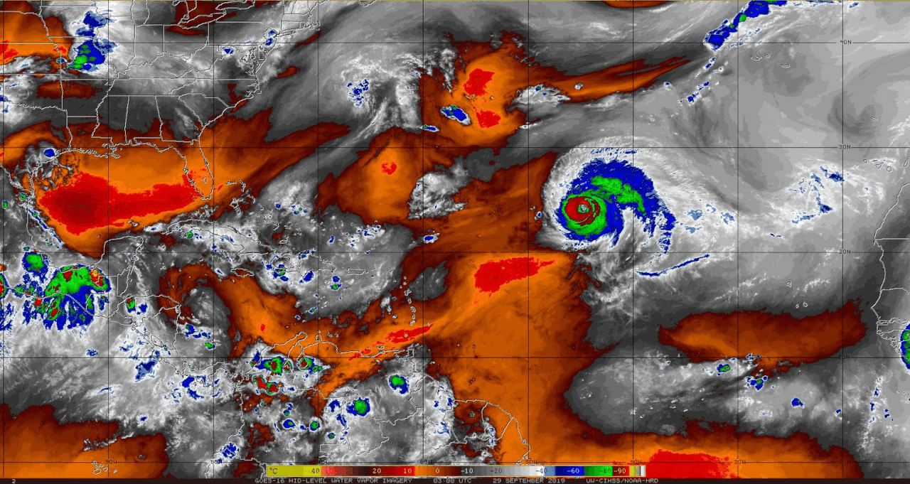
2 likes
TC naming lists: retirements and intensity
Most aggressive Advisory #1's in North Atlantic (cr. kevin for starting the list)
Most aggressive Advisory #1's in North Atlantic (cr. kevin for starting the list)
-
TomballEd
- Category 5

- Posts: 1315
- Age: 62
- Joined: Wed Aug 16, 2023 4:52 pm
- Location: Spring/Klein area, not Tomball
Re: 2025 Indicators: SST's, MSLP, Shear, SAL, Steering, Instability (Day 16+ Climate Models)
I certainly wouldn't say complete season cancel. Late September/October will produce at least one SW Gulf or Caribbean storm, and Ian, Laura and Michael type high major storms seem more common than they used to. They'll be some subtropical trash between Bermuda and the Azores that will be named, that happens every year.
Euro seeing slightly above average ACE starting around the Equinox, which would perhaps fit my late September/early October storms Caribbean storm or storms. Although TC probabilities may be suggesting the Euro sees another CV/Atlantic MDR storm that likely recurves. Note BoC probs however. Past 10 days the 0Z Euro ensembles starts suggesting some support for storms either side of Central America. The GFS ensembles and the most recent Op GFS would support that as well, although Euro weeklies ACE seem to suggests the real CAG stuff is beyond the 16 day range. Or, the GFS family would be in the 0-16 day thread and the Euro family would be in the Day 16+ thread.

Euro seeing slightly above average ACE starting around the Equinox, which would perhaps fit my late September/early October storms Caribbean storm or storms. Although TC probabilities may be suggesting the Euro sees another CV/Atlantic MDR storm that likely recurves. Note BoC probs however. Past 10 days the 0Z Euro ensembles starts suggesting some support for storms either side of Central America. The GFS ensembles and the most recent Op GFS would support that as well, although Euro weeklies ACE seem to suggests the real CAG stuff is beyond the 16 day range. Or, the GFS family would be in the 0-16 day thread and the Euro family would be in the Day 16+ thread.
0 likes
-
tolakram
- Admin

- Posts: 20186
- Age: 62
- Joined: Sun Aug 27, 2006 8:23 pm
- Location: Florence, KY (name is Mark)
Re: 2025 Indicators: SST's, MSLP, Shear, SAL, Steering, Instability (Day 16+ Climate Models)
Dry air can prevent formation but once the engine is running it doesn't matter unless wind shear pushes that dry air into the core.
91L had a pocket, missed it, poofed. According to the posts on this forum the Atlantic has suffered from dry air and stability for the last 20 years.
91L had a pocket, missed it, poofed. According to the posts on this forum the Atlantic has suffered from dry air and stability for the last 20 years.
3 likes
M a r k
- - - - -
Join us in chat: Storm2K Chatroom Invite. Android and IOS apps also available.
The posts in this forum are NOT official forecasts and should not be used as such. Posts are NOT endorsed by any professional institution or STORM2K.org. For official information and forecasts, please refer to NHC and NWS products.
-
HurricaneRyan
- Category 3

- Posts: 847
- Age: 32
- Joined: Sun Dec 05, 2010 3:05 pm
Re: 2025 Indicators: SST's, MSLP, Shear, SAL, Steering, Instability (Day 16+ Climate Models)
I wouldn't season-cancel just yet.
2022 and 2024 gave us Ian and Helene respectively in late September so Mother Nature can easily shut you up when she wants to.
2022 and 2024 gave us Ian and Helene respectively in late September so Mother Nature can easily shut you up when she wants to.
2 likes
Kay '22 Hilary '23

Re: 2025 Indicators: SST's, MSLP, Shear, SAL, Steering, Instability (Day 16+ Climate Models)
MetroMike wrote:chaser1 wrote:MetroMike wrote:In Joe Bastardi's free Saturday summery video he was making comparisons with last year mid to late September with the MJO placement in 2024 and this years predicted placement along with similar pressure placements.
Very similar moisture in the western basin also.
Seems any threats for the conus will come from the western basin and not the MDR.
Shall see if this pans out.
I would actually be very curious to go back in time and compare last years MJO for September '24 and this year for myself. I don't specifically recall if last year's MJO was rather muted (close to or within the circle) or significantly more heightened?
Yes if you watch Joe's video from Saturday he shows the MJO from late September last year and it was more muted but over South America and the conus.
This year’s MJO forecast looks to be less muted and centered over the western basin also.
Thanks! That would lead me to think that mid level humidity issues will be soon moistened up in about a week or so
0 likes
Andy D
(For official information, please refer to the NHC and NWS products.)
(For official information, please refer to the NHC and NWS products.)
Re: 2025 Indicators: SST's, MSLP, Shear, SAL, Steering, Instability (Day 16+ Climate Models)
chaser1 wrote:MetroMike wrote:In Joe Bastardi's free Saturday summery video he was making comparisons with last year mid to late September with the MJO placement in 2024 and this years predicted placement along with similar pressure placements.
Very similar moisture in the western basin also.
Seems any threats for the conus will come from the western basin and not the MDR.
Shall see if this pans out.
I would actually be very curious to go back in time and compare last years MJO for September '24 and this year for myself. I don't specifically recall if last year's MJO was rather muted (close to or within the circle) or significantly more heightened?
Highly impactful hurricanes while MJO inside circle (all or much of)
-‘24: Debby (most incl. when strongest), Francine, Milton
-‘23: Idalia
-‘22: Fiona, Ian
-‘20: Eta (most incl. when strongest)
-‘19: Dorian (5 of its days including when strongest)
-‘17: Harvey (most of incl. almost entire time was H), Irma, Maria
-‘16: Hermine, Nicole (almost all)
-‘10: Igor (most of), Karl
-‘08: Paloma (all but last day when weakened to TS/TD)
-‘05: Katrina
-‘03: Fabian (nearly all), Juan
-‘99: Floyd
-‘98: Mitch
-‘96: Fran (most incl. nearly entire time it was TS+)
-‘95: Marilyn (most of), Opal
-‘93: Emily
-‘92: Andrew (most including entire time it was an H)
-‘91: Grace/perfect storm
-‘88: Gilbert (most of incl. at strongest)
-‘85: Elena
-‘75: Eloise
So, 30 of the most impactful hurricanes on land since 1975 (excluding 1978 because no MJO available) were inside the circle at least during when they had their biggest impact. That’s out of 84 quite impactful hurricanes overall for the same period. So, 30/84 is 36%.
So, the data’s not saying inside is more conducive than or even as conducive as outside. Rather, it’s saying that very bad storms can be during inside MJO and that was the case for these 30. Note some of the most notorious are in those 30 like Gilbert, Andrew, Mitch, Katrina, Harvey, Irma, Maria, Dorian, Eta (in Honduras), and Ian.
Of the 30 highly impactful hurricanes that occurred when inside the circle, 9 reached cat 5: Gilbert, Andrew, Mitch, Katrina, Irma, Maria, Dorian, Ian, and Milton. There have been a total of 23 highly impactful hurricanes that peaked as a cat 5 since 1975. That means that 9/23 or 39% of those were when the MJO was inside.
Link to MJO history:
http://www.bom.gov.au/climate/mjo/#tabs=Monitoring
7 likes
Personal Forecast Disclaimer:
The posts in this forum are NOT official forecasts and should not be used as such. They are just the opinion of the poster and may or may not be backed by sound meteorological data. They are NOT endorsed by any professional institution or storm2k.org. For official information, please refer to the NHC and NWS products.
The posts in this forum are NOT official forecasts and should not be used as such. They are just the opinion of the poster and may or may not be backed by sound meteorological data. They are NOT endorsed by any professional institution or storm2k.org. For official information, please refer to the NHC and NWS products.
-
Stratton23
- Category 5
- Posts: 3571
- Joined: Fri Jul 21, 2023 10:59 pm
- Location: Katy, Tx
Re: 2025 Indicators: SST's, MSLP, Shear, SAL, Steering, Instability (Day 16+ Climate Models)
EPS/ GEFS agree on a strong MJO rotation outside the circle into phases 8/1 in the atlantic and maybe staying their for a while, should be a matter of time before models wake up and see this, I seriously doubt the rest of the season is this quiet , as always stay vigilant on the gulf coast and SE US, it only takes one storm to be a bad season for many and we got plenty of time left for that to happen
9 likes

Re: 2025 Indicators: SST's, MSLP, Shear, SAL, Steering, Instability (Day 16+ Climate Models)
Yeah, 2025 is a tricky season and could very well blow up around 9/25 and into the rest of the Fall.
Backloaded season makes more sense, like last year and 2022. 2001 also comes to mind.
Really will depend on that MJO.
Backloaded season makes more sense, like last year and 2022. 2001 also comes to mind.
Really will depend on that MJO.
0 likes
Georges '98, Irene '99, Frances '04, Jeanne '04, Katrina '05, Wilma '05, Gustav '08, Isaac '12, Matthew '16, Florence '18, Michael '18, Ian '22

Re: 2025 Indicators: SST's, MSLP, Shear, SAL, Steering, Instability (Day 16+ Climate Models)
Its definitely possible. We've had so many backloaded seasons in recent memory that it's hard to be confident though. This does remind me of last season, but at some point a below average season is bound to actually happen.MarioProtVI wrote:I think it’s even more troubling when the CFS doesn’t show any signs of an increase in activity - over the last several days has persistently shown only one or two weak short-lived systems tracking across the basin the entire run despite the supposed MJO coming around 9/20. At this point it seems very very likely we are heading for a below-average season, and it’s possible we don’t get past 75 ACE by seasons end.
Ignoring real indicators the last below average season was 2015 so it would be fitting for the season 10 years later to be the end of the streak.
0 likes
Re: 2025 Indicators: SST's, MSLP, Shear, SAL, Steering, Instability (Day 16+ Climate Models)
Woofde wrote:Its definitely possible. We've had so many backloaded seasons in recent memory that it's hard to be confident though. This does remind me of last season, but at some point a below average season is bound to actually happen.MarioProtVI wrote:I think it’s even more troubling when the CFS doesn’t show any signs of an increase in activity - over the last several days has persistently shown only one or two weak short-lived systems tracking across the basin the entire run despite the supposed MJO coming around 9/20. At this point it seems very very likely we are heading for a below-average season, and it’s possible we don’t get past 75 ACE by seasons end.
Ignoring real indicators the last below average season was 2015 so it would be fitting for the season 10 years later to be the end of the streak.
And 2015 was a strong El Niño vs the current weak La Niña.
1 likes
Personal Forecast Disclaimer:
The posts in this forum are NOT official forecasts and should not be used as such. They are just the opinion of the poster and may or may not be backed by sound meteorological data. They are NOT endorsed by any professional institution or storm2k.org. For official information, please refer to the NHC and NWS products.
The posts in this forum are NOT official forecasts and should not be used as such. They are just the opinion of the poster and may or may not be backed by sound meteorological data. They are NOT endorsed by any professional institution or storm2k.org. For official information, please refer to the NHC and NWS products.
-
MarioProtVI
- Category 5
- Posts: 1038
- Age: 24
- Joined: Sun Sep 29, 2019 7:33 pm
- Location: New Jersey
Re: 2025 Indicators: SST's, MSLP, Shear, SAL, Steering, Instability (Day 16+ Climate Models)
No matter what happens with the rest of the season, there's no denying the current peak season dead streak is remarkable and incredibly anomalous. There's a 9 out of 10 chance of a storm on 9-10 and this year we will be upper decile dead. Maybe we have a backloaded season...or not. no one knows. the one thing that is certain is prime hurricane season days are effortlessly slipping past the goalie and fall like weather and dew points are digging way south. maybe we get a year off for a change. we have certainly earned it. this post may look silly in a few weeks...or not..
8 likes
-
cycloneye

- Admin
- Posts: 149667
- Age: 69
- Joined: Thu Oct 10, 2002 10:54 am
- Location: San Juan, Puerto Rico
Re: 2025 Indicators: SST's, MSLP, Shear, SAL, Steering, Instability (Day 16+ Climate Models)
0 likes
Visit the Caribbean-Central America Weather Thread where you can find at first post web cams,radars
and observations from Caribbean basin members Click Here
and observations from Caribbean basin members Click Here
-
WeatherBoy2000
- Category 1

- Posts: 463
- Joined: Mon Apr 10, 2023 9:29 am
Re: 2025 Indicators: SST's, MSLP, Shear, SAL, Steering, Instability (Day 16+ Climate Models)
psyclone wrote:No matter what happens with the rest of the season, there's no denying the current peak season dead streak is remarkable and incredibly anomalous. There's a 9 out of 10 chance of a storm on 9-10 and this year we will be upper decile dead. Maybe we have a backloaded season...or not. no one knows. the one thing that is certain is prime hurricane season days are effortlessly slipping past the goalie and fall like weather and dew points are digging way south. maybe we get a year off for a change. we have certainly earned it. this post may look silly in a few weeks...or not..
What's even crazier is that this has happened two years in a row. Since 2022, the only season that's had a relatively normal peak was 2023, the strong el nino year. Whatever is going on, no one really seems to have much of a clue, and it's throwing off models and forecasters.
3 likes
-
WeatherBoy2000
- Category 1
- Posts: 463
- Joined: Mon Apr 10, 2023 9:29 am
Re: 2025 Indicators: SST's, MSLP, Shear, SAL, Steering, Instability (Day 16+ Climate Models)
WeatherBoy2000 wrote:psyclone wrote:No matter what happens with the rest of the season, there's no denying the current peak season dead streak is remarkable and incredibly anomalous. There's a 9 out of 10 chance of a storm on 9-10 and this year we will be upper decile dead. Maybe we have a backloaded season...or not. no one knows. the one thing that is certain is prime hurricane season days are effortlessly slipping past the goalie and fall like weather and dew points are digging way south. maybe we get a year off for a change. we have certainly earned it. this post may look silly in a few weeks...or not..
What's even crazier is that this has happened two years in a row. Since 2022, the only season that's had a relatively normal peak was 2023, the strong el nino year. Whatever is going on, no one really seems to have much of a clue, and it's throwing off models and forecasters.
Just to follow up further, even CSU now admits to being a bit perplexed by what's happening:
https://x.com/philklotzbach/status/1965475432977080362
1 likes
-
Stratton23
- Category 5
- Posts: 3571
- Joined: Fri Jul 21, 2023 10:59 pm
- Location: Katy, Tx
Re: 2025 Indicators: SST's, MSLP, Shear, SAL, Steering, Instability (Day 16+ Climate Models)
MJO goes into 8 /1/2 and potentially 2 around 9/20 in the atlantic, if we dont get any activity out of a favorable MJO passage , ill be completely dumbfounded to be honest, but as yogi bear said “ It aint over till its over” we still got a lot of time left for some surprises to happen
0 likes
-
CyclonicFury

- Category 5
- Posts: 2038
- Age: 27
- Joined: Sun Jul 02, 2017 12:32 pm
- Location: NC
- Contact:
Re: 2025 Indicators: SST's, MSLP, Shear, SAL, Steering, Instability (Day 16+ Climate Models)
One interesting difference about 2025 compared to recent years is the African Standing Wave that led to stronger than normal AEWs and above normal precip in the Sahel for much of the last decade seems to be completely gone. I noticed Dr. Klotzbach mentioned this in his discussion, an indicator that has not been discussed much yet but could explain we have seen so few attempts at MDR activity.


I wonder if this is a fluke, or a sign that the Sahel is heading for a drier period. That would have major implications for upcoming seasons.
I wonder if this is a fluke, or a sign that the Sahel is heading for a drier period. That would have major implications for upcoming seasons.
9 likes
NCSU B.S. in Meteorology Class of 2021. Tropical weather blogger at http://www.cyclonicfury.com. My forecasts and thoughts are NOT official, for official forecasts please consult the National Hurricane Center.
-
TomballEd
- Category 5
- Posts: 1315
- Age: 62
- Joined: Wed Aug 16, 2023 4:52 pm
- Location: Spring/Klein area, not Tomball
Re: 2025 Indicators: SST's, MSLP, Shear, SAL, Steering, Instability (Day 16+ Climate Models)
CyclonicFury wrote:One interesting difference about 2025 compared to recent years is the African Standing Wave that led to stronger than normal AEWs and above normal precip in the Sahel for much of the last decade seems to be completely gone. I noticed Dr. Klotzbach mentioned this in his discussion, an indicator that has not been discussed much yet but could explain we have seen so few attempts at MDR activity.
https://i.imgur.com/K411u0V.png
https://i.imgur.com/zWgwyQG.png
I wonder if this is a fluke, or a sign that the Sahel is heading for a drier period. That would have major implications for upcoming seasons.
I see CSU mentioning Sahel rain now but it wasn't one of the April factors. Dr. Gray, back when he was the head forecaster, used Sahel rainfall as one of his tools, I believe it was pretty accurate developing hindcast predictions.
0 likes
Who is online
Users browsing this forum: hurricanes1234 and 209 guests