

It just gets trapped on Bermuda in the 18z GFS run. The ridging doesn't let it go North and there's nothing to push it west either. Definitely a la la land run imo.
Sent from my SM-G988U1 using Tapatalk
Strong Tropical Wave Emerging From West Africa (Is Invest 92L)
Moderator: S2k Moderators
Forum rules

The posts in this forum are NOT official forecasts and should not be used as such. They are just the opinion of the poster and may or may not be backed by sound meteorological data. They are NOT endorsed by any professional institution or STORM2K. For official information, please refer to products from the National Hurricane Center and National Weather Service.
-
Category5Kaiju

- Category 5

- Posts: 4347
- Joined: Thu Dec 24, 2020 12:45 pm
- Location: Seattle during the summer, Phoenix during the winter
Re: Strong Tropical Wave to emerge West Africa on Thursday
Woofde wrote:It just gets trapped on Bermuda in the 18z GFS run. The ridging doesn't let it go North and there's nothing to push it west either. Definitely a la la land run imo.
Sent from my SM-G988U1 using Tapatalk
Would be enough to give Bermuda Fabian flashbacks (also, fun thing to note, assuming this does become Fred, Fabian was the name used before Fred replaced it
0 likes
Unless explicitly stated, all information in my posts is based on my own opinions and observations. Tropical storms and hurricanes can be extremely dangerous. Refer to an accredited weather research agency or meteorologist if you need to make serious decisions regarding an approaching storm.

Re: Strong Tropical Wave to emerge West Africa on Thursday
18z ensembles on WeatherNerds are quite active. However, the 18z GEFS ensembles on Tropical Tidbits are less active than 12z.
GFS tries to develop this in its first 48 hours over water. The NHC is saying it’ll splash down tomorrow night, but it looks like it might come off a little earlier.
GFS tries to develop this in its first 48 hours over water. The NHC is saying it’ll splash down tomorrow night, but it looks like it might come off a little earlier.
Last edited by aspen on Wed Aug 04, 2021 6:37 pm, edited 1 time in total.
0 likes
Irene '11 Sandy '12 Hermine '16 5/15/2018 Derecho Fay '20 Isaias '20 Elsa '21 Henri '21 Ida '21
I am only a meteorology enthusiast who knows a decent amount about tropical cyclones. Look to the professional mets, the NHC, or your local weather office for the best information.
I am only a meteorology enthusiast who knows a decent amount about tropical cyclones. Look to the professional mets, the NHC, or your local weather office for the best information.
-
cycloneye

- Admin

- Posts: 149730
- Age: 69
- Joined: Thu Oct 10, 2002 10:54 am
- Location: San Juan, Puerto Rico
Re: Strong Tropical Wave to emerge West Africa on Thursday
A tropical wave is forecast to move off the west coast of Africa
by late Thursday. Environmental conditions appear somewhat
conducive for gradual development thereafter over the eastern
tropical Atlantic through the weekend into early next week while the
system moves westward to west-northwestward at about 15 mph.
* Formation chance through 48 hours...low...near 0 percent.
* Formation chance through 5 days...medium...40 percent.
0 likes
Visit the Caribbean-Central America Weather Thread where you can find at first post web cams,radars
and observations from Caribbean basin members Click Here
and observations from Caribbean basin members Click Here
-
Stormybajan

- Category 1

- Posts: 453
- Joined: Thu May 20, 2021 3:21 pm
- Location: Windward Islands
Re: Strong Tropical Wave to emerge West Africa on Thursday
cycloneye wrote:Big ACE producer if it does what 18Z GFS has. What about a powerful hurricane?
https://i.imgur.com/8Qzh2cp.png
This is just like that random run gfs had at 06z August 1st. I'll believe this when I see it
0 likes
Sad West Indies and Manchester United fan ⚽️
-
gatorcane

- S2K Supporter

- Posts: 23708
- Age: 48
- Joined: Sun Mar 13, 2005 3:54 pm
- Location: Boca Raton, FL
Re: Strong Tropical Wave to emerge West Africa on Thursday
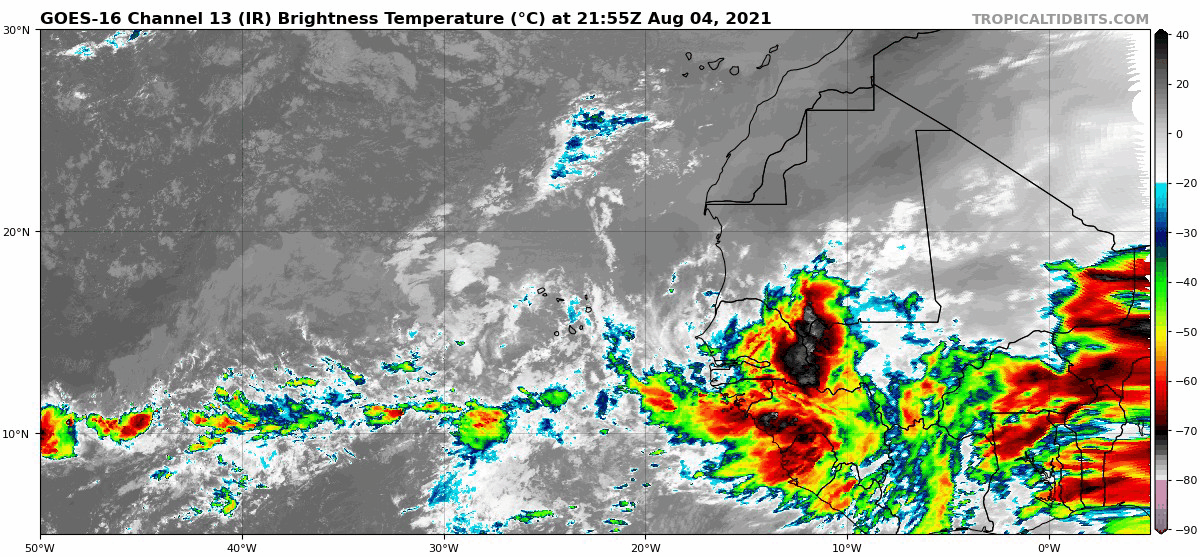
Looks impressive but the MDR is quite dry and stable so let’s see after it makes the splash which it should be doing in the next 24 hours or so:
6 likes
-
AlphaToOmega
- Category 5
- Posts: 1448
- Joined: Sat Jun 26, 2021 10:51 am
- Location: Somewhere in Massachusetts
Re: Strong Tropical Wave to emerge West Africa on Thursday
Remember that waves can create favorable conditions for other waves. Waves can sacrifice themselves for other waves.
2 likes
Re: Strong Tropical Wave to emerge West Africa on Thursday
gatorcane wrote:Looks impressive but the MDR is quite dry and stable so let’s see after it makes the splash which it should be doing in the next 24 hours or so:
https://i.postimg.cc/SQGC5zyW/goes16-ir-eatl.gif
Convection has noticeably increased in the MDR over the last week, though, as the MJO slowly slides into a more favorable pattern for the Atlantic. If this wave stays south enough, it could avoid most of the stable air during its early formation stages.
0 likes
Irene '11 Sandy '12 Hermine '16 5/15/2018 Derecho Fay '20 Isaias '20 Elsa '21 Henri '21 Ida '21
I am only a meteorology enthusiast who knows a decent amount about tropical cyclones. Look to the professional mets, the NHC, or your local weather office for the best information.
I am only a meteorology enthusiast who knows a decent amount about tropical cyclones. Look to the professional mets, the NHC, or your local weather office for the best information.
-
cycloneye
- Admin
- Posts: 149730
- Age: 69
- Joined: Thu Oct 10, 2002 10:54 am
- Location: San Juan, Puerto Rico
Re: Strong Tropical Wave to emerge West Africa on Thursday
1 likes
Visit the Caribbean-Central America Weather Thread where you can find at first post web cams,radars
and observations from Caribbean basin members Click Here
and observations from Caribbean basin members Click Here
-
ConvergenceZone
.gif)
- Category 5
- Posts: 5241
- Joined: Fri Jul 29, 2005 1:40 am
- Location: Northern California
Re: Strong Tropical Wave to emerge West Africa on Thursday
tolakram wrote:Shell Mound wrote:aspen wrote:Quite an uptick in activity from the 12 GEFS ensembles. All of them recurve, but it appears to be due to the wave being tossed a little further north by the monsoon trough...
I’ll reiterate: this latest 12Z run just proves my earlier supposition that the strong African monsoon will cause lots of systems to eject northward and curve OTS. This will likely save the U.S. from most, if not all, potential CV-type threats, including this one, despite otherwise strong and robust mid-level ridging projected to be in place. The main issue is that the monsoonal trough will cause this system to eject westward at a high latitude that typically results in CV-type long-trackers curving OTS, especially in years in which TCG occurs farther east in the MDR than is usual. Starting in two and a half days the 12Z GEFS members show this prospective system gaining a full five degrees of latitude in little more than a day, thanks to the monsoonal trough. This will likely become a seasonal trend, thankfully, but we shall see.
Looks to me like a normal CV type system that will recurve, hopefully, like 99% of these storm do. I don't see any feature that guarantees this recurve though, and I feel like the timing of development is more important to future track. Quick developers tend to recurve away from the US mainland. I question why suddenly the eastern MDR might be so favorable when it seems some of us thought it wouldn't be.
I don't think I would put a normal recurve % near that high at 99%. I can't imagine 100 storms forming off the coast of Africa and only 1 out of 100 making it to the USA mainland...
4 likes
-
Category5Kaiju
- Category 5
- Posts: 4347
- Joined: Thu Dec 24, 2020 12:45 pm
- Location: Seattle during the summer, Phoenix during the winter
Re: Strong Tropical Wave to emerge West Africa on Thursday
We'll have to watch to know for sure, but wouldn't a system that exits at a lower latitude have more difficulty recurving than those at higher latitudes?
0 likes
Unless explicitly stated, all information in my posts is based on my own opinions and observations. Tropical storms and hurricanes can be extremely dangerous. Refer to an accredited weather research agency or meteorologist if you need to make serious decisions regarding an approaching storm.
-
captainbarbossa19

- Professional-Met

- Posts: 1094
- Age: 27
- Joined: Wed Aug 21, 2019 11:09 pm
- Location: Beaumont, TX
Re: Strong Tropical Wave to emerge West Africa on Thursday
Category5Kaiju wrote:We'll have to watch to know for sure, but wouldn't a system that exits at a lower latitude have more difficulty recurving than those at higher latitudes?
Generally, this is the case. Speaking of which, the 0z GFS is showing this system a little more towards the south than the previous run.
0 likes
-
DorkyMcDorkface

- Category 5
- Posts: 1045
- Age: 28
- Joined: Mon Sep 30, 2019 1:32 pm
- Location: Mid-Atlantic
Re: Strong Tropical Wave to emerge West Africa on Thursday
00z UKMET:
NEW TROPICAL CYCLONE FORECAST TO DEVELOP AFTER 66 HOURS
FORECAST POSITION AT T+ 66 : 13.0N 28.1W
LEAD CENTRAL MAXIMUM WIND
VERIFYING TIME TIME POSITION PRESSURE (MB) SPEED (KNOTS)
-------------- ---- -------- ------------- -------------
0000UTC 08.08.2021 72 13.5N 29.1W 1012 24
1200UTC 08.08.2021 84 14.7N 31.7W 1011 27
0000UTC 09.08.2021 96 15.3N 35.1W 1012 29
1200UTC 09.08.2021 108 15.7N 38.9W 1011 29
0000UTC 10.08.2021 120 15.4N 41.5W 1011 26
1200UTC 10.08.2021 132 16.6N 43.3W 1011 27
0000UTC 11.08.2021 144 18.6N 46.6W 1011 30
Last edited by DorkyMcDorkface on Wed Aug 04, 2021 11:18 pm, edited 1 time in total.
1 likes
Please note the thoughts expressed by this account are solely those of the user and are from a hobbyist perspective. For more comprehensive analysis, consult an actual professional meteorologist or meteorological agency.
Floyd 1999 | Isabel 2003 | Hanna 2008 | Irene 2011 | Sandy 2012 | Isaias 2020
-
captainbarbossa19
- Professional-Met
- Posts: 1094
- Age: 27
- Joined: Wed Aug 21, 2019 11:09 pm
- Location: Beaumont, TX
Re: Strong Tropical Wave to emerge West Africa on Thursday
DorkyMcDorkface wrote:NEW TROPICAL CYCLONE FORECAST TO DEVELOP AFTER 66 HOURS
FORECAST POSITION AT T+ 66 : 13.0N 28.1W
LEAD CENTRAL MAXIMUM WIND
VERIFYING TIME TIME POSITION PRESSURE (MB) SPEED (KNOTS)
-------------- ---- -------- ------------- -------------
0000UTC 08.08.2021 72 13.5N 29.1W 1012 24
1200UTC 08.08.2021 84 14.7N 31.7W 1011 27
0000UTC 09.08.2021 96 15.3N 35.1W 1012 29
1200UTC 09.08.2021 108 15.7N 38.9W 1011 29
0000UTC 10.08.2021 120 15.4N 41.5W 1011 26
1200UTC 10.08.2021 132 16.6N 43.3W 1011 27
0000UTC 11.08.2021 144 18.6N 46.6W 1011 30
Is this the UKMET?
0 likes
-
weeniepatrol

- Category 5
- Posts: 1345
- Joined: Sat Aug 22, 2020 5:30 pm
- Location: WA State

-
DorkyMcDorkface
- Category 5
- Posts: 1045
- Age: 28
- Joined: Mon Sep 30, 2019 1:32 pm
- Location: Mid-Atlantic
Re: Strong Tropical Wave to emerge West Africa on Thursday
captainbarbossa19 wrote:DorkyMcDorkface wrote:NEW TROPICAL CYCLONE FORECAST TO DEVELOP AFTER 66 HOURS
FORECAST POSITION AT T+ 66 : 13.0N 28.1W
LEAD CENTRAL MAXIMUM WIND
VERIFYING TIME TIME POSITION PRESSURE (MB) SPEED (KNOTS)
-------------- ---- -------- ------------- -------------
0000UTC 08.08.2021 72 13.5N 29.1W 1012 24
1200UTC 08.08.2021 84 14.7N 31.7W 1011 27
0000UTC 09.08.2021 96 15.3N 35.1W 1012 29
1200UTC 09.08.2021 108 15.7N 38.9W 1011 29
0000UTC 10.08.2021 120 15.4N 41.5W 1011 26
1200UTC 10.08.2021 132 16.6N 43.3W 1011 27
0000UTC 11.08.2021 144 18.6N 46.6W 1011 30
Is this the UKMET?
Yes. Should've denoted that, sorry.
2 likes
Please note the thoughts expressed by this account are solely those of the user and are from a hobbyist perspective. For more comprehensive analysis, consult an actual professional meteorologist or meteorological agency.
Floyd 1999 | Isabel 2003 | Hanna 2008 | Irene 2011 | Sandy 2012 | Isaias 2020
-
Category5Kaiju
- Category 5
- Posts: 4347
- Joined: Thu Dec 24, 2020 12:45 pm
- Location: Seattle during the summer, Phoenix during the winter
Re: Strong Tropical Wave to emerge West Africa on Thursday
0z GFS nowhere near as strong as 18z GFS, but the storm does not go OTS; rather, it seems to take one of those dreaded S-curve paths toward the Bahamas (when I say "S-curve," I refer to those paths like Andrew, Dorian, Frances, Floyd, or Donna, where the storm seems to turn north initially but then abruptly heads westward)
0 likes
Unless explicitly stated, all information in my posts is based on my own opinions and observations. Tropical storms and hurricanes can be extremely dangerous. Refer to an accredited weather research agency or meteorologist if you need to make serious decisions regarding an approaching storm.

Re: Strong Tropical Wave to emerge West Africa on Thursday
Category5Kaiju wrote:0z GFS nowhere near as strong as 18z GFS, but the storm does not go OTS; rather, it seems to take one of those dreaded S-curve paths toward the Bahamas (when I say "S-curve," I refer to those paths like Andrew, Dorian, Frances, Floyd, or Donna, where the storm seems to turn north initially but then abruptly heads westward)
Seems like it recurves right before reaching the Outer Banks.
Obviously one shouldn't take these 384 hr runs at face value, but they do show there's a wide range of possibilities (dissipation in the MDR, major in subtropics, CONUS hit, etc).
0 likes
TC naming lists: retirements and intensity
Most aggressive Advisory #1's in North Atlantic (cr. kevin for starting the list)
Most aggressive Advisory #1's in North Atlantic (cr. kevin for starting the list)
-
ScottNAtlanta

- Category 5
- Posts: 2535
- Joined: Sat May 25, 2013 3:11 pm
- Location: Atlanta, GA
Re: Strong Tropical Wave to emerge West Africa on Thursday
GFS takes it about 2/3s of the way across and then kills it and moves it north. That makes no sense at all. If anything that's when the water really starts to warm, and I see no reason in its synoptic pattern for this to just poof like that. Again, though...that is way out. Lets see if the convection maintains as it is exiting the coast now. It even looks like it has some spin to it.
0 likes
The posts in this forum are NOT official forecast and should not be used as such. They are just the opinion of the poster and may or may not be backed by sound meteorological data. They are NOT endorsed by any professional institution or storm2k.org. For official information, please refer to the NHC and NWS products.

Re: Strong Tropical Wave to emerge West Africa on Thursday
Category5Kaiju wrote:0z GFS nowhere near as strong as 18z GFS, but the storm does not go OTS; rather, it seems to take one of those dreaded S-curve paths toward the Bahamas (when I say "S-curve," I refer to those paths like Andrew, Dorian, Frances, Floyd, or Donna, where the storm seems to turn north initially but then abruptly heads westward)
Specifically such type track that will likely pose the greatest risk to the SE CONUS, the Bahamas, and notably Florida this year. W. Atlantic ridge heights and especially ridge orientation will ultimately dictate enhanced landfall risk at that time. Aside from what has been a largely predominant strong mid level ridge pattern over the far W. Atlantic basin thus far, August is NOT the month the Florida Chamber of Commerce would want to be eyeballing an intensifying tropical cyclone just north of P.R.
3 likes
Andy D
(For official information, please refer to the NHC and NWS products.)
(For official information, please refer to the NHC and NWS products.)
Who is online
Users browsing this forum: No registered users and 129 guests