
Surface Trough East of Florida (Is Invest 90L)
Moderator: S2k Moderators
Forum rules

The posts in this forum are NOT official forecasts and should not be used as such. They are just the opinion of the poster and may or may not be backed by sound meteorological data. They are NOT endorsed by any professional institution or STORM2K. For official information, please refer to products from the National Hurricane Center and National Weather Service.
-
tolakram
- Admin

- Posts: 20186
- Age: 62
- Joined: Sun Aug 27, 2006 8:23 pm
- Location: Florence, KY (name is Mark)
If it's anything like last year the Euro sniffs it out long range, then has issues mid range, then will pick it back up short range. It will be interesting to see if this season, or at least this storm, shows the same pattern.
0 likes
M a r k
- - - - -
Join us in chat: Storm2K Chatroom Invite. Android and IOS apps also available.
The posts in this forum are NOT official forecasts and should not be used as such. Posts are NOT endorsed by any professional institution or STORM2K.org. For official information and forecasts, please refer to NHC and NWS products.


-
TropicalAnalystwx13

- Category 5

- Posts: 2109
- Age: 28
- Joined: Tue Jul 19, 2011 8:20 pm
- Location: Wilmington, NC
- Contact:
NWS ILM AFD:
.LONG TERM /WEDNESDAY THROUGH SUNDAY/...
AS OF 3 PM SUNDAY...THE ENTIRETY OF THE LONG TERM WILL FOCUS ON
WHAT IS EXPECTED TO BECOME A HYBRID/SUB-TROPICAL LOW OFF MEANDERING
OFF THE SOUTHEAST COAST. LARGE AREA OF DISTURBED WEATHER WILL MOVE
OUT OF THE CARIBBEAN AND THEN STRENGTHEN INTO A LOW PRESSURE SYSTEM
WELL OFFSHORE. THIS OCCURS IN A REGION OF VERY WEAK STEERING FLOW IN
THE VICINITY OF A LARGE MID-LEVEL RIDGE ACROSS THE SOUTHEAST...AND
THUS THERE IS VERY LITTLE CONFIDENCE IN WHAT THIS SYSTEM WILL DO
ONCE IT DEVELOPS...AND GUIDANCE IS ALL OVER THE PLACE IN HOW THE LOW
WILL TRACK. HOWEVER...THERE IS INCREASING CONFIDENCE THAT A HYBRID-
LOW WILL DEVELOP...BECOMING WARM CORE AND LIKELY STRENGTHENING
THANKS TO A COMBINATION OF LATENT HEAT RELEASE FROM 80 DEGREE WATERS
IN THE GULF STREAM...BAROCLINIC INSTABILITY DUE TO CHANGE IN WATER
TEMPS NEAR THE COAST...AND GOOD VENTILATION THROUGH DIFFLUENCE
ALOFT. WILL NOT MAKE ANY WHOLESALE CHANGES TO POP/WX IN THE EXTENDED
DUE TO SUCH LOW CONFIDENCE...AND WILL MAINTAIN THE INHERITED POP FOR
THE THU-SUN TIMEFRAME...HIGHEST CHANCE AT THE COAST. STILL...CANNOT
FOCUS ON ANY SPECIFIC DAY BEING THE MOST FAVORABLE FOR PRECIP AS THE
GUIDANCE ENVELOPE IS SO WIDE. ON THE BRIGHT SIDE...TEMPS THROUGH THE
PERIOD SHOULD BE ABOVE CLIMO...ESPECIALLY AWAY FROM THE COAST.
0 likes

-
floridasun78
- Category 5
- Posts: 3755
- Joined: Sun May 17, 2009 10:16 pm
- Location: miami fl
Re: Potential Development off the Southeast U.S. Coastline
NWS ILM AFD???? what weather station that?
0 likes
-
TropicalAnalystwx13
- Category 5
- Posts: 2109
- Age: 28
- Joined: Tue Jul 19, 2011 8:20 pm
- Location: Wilmington, NC
- Contact:
Re: Potential Development off the Southeast U.S. Coastline
floridasun78 wrote:NWS ILM AFD???? what weather station that?
NWS ILM is the local office here in Wilmington, North Carolina.
0 likes
-
floridasun78
- Category 5
- Posts: 3755
- Joined: Sun May 17, 2009 10:16 pm
- Location: miami fl
Re: Potential Development off the Southeast U.S. Coastline
TropicalAnalystwx13 wrote:floridasun78 wrote:NWS ILM AFD???? what weather station that?
NWS ILM is the local office here in Wilmington, North Carolina.
ok
0 likes
-
floridasun78
- Category 5
- Posts: 3755
- Joined: Sun May 17, 2009 10:16 pm
- Location: miami fl

-
TheAustinMan

- Category 5
- Posts: 1060
- Joined: Mon Jul 08, 2013 4:26 pm
- Location: Central TX / United States
Some things to watch for for the remainder of tonight (May 3, 2015).

What you are looking at: Annotated satellite map showing some features of note. Not official!
Source: Annotations mine. Background image NASA/MSFC
What you are looking at: Annotated satellite map showing some features of note. Not official!
Source: Annotations mine. Background image NASA/MSFC
Last edited by TheAustinMan on Sun May 03, 2015 9:18 pm, edited 2 times in total.
0 likes
Treat my opinions with a grain of salt. For official information see your local weather service.
“It's tough to make predictions, especially about the future.”
“It's tough to make predictions, especially about the future.”
-
SeGaBob
Re: Re:
TheStormExpert wrote:SeGaBob wrote:SPECIAL TROPICAL WEATHER OUTLOOK
NWS NATIONAL HURRICANE CENTER MIAMI FL
1030 AM EDT SUN MAY 3 2015
For the North Atlantic...Caribbean Sea and the Gulf of Mexico:
A non-tropical area of low pressure is expected to form north of
the Bahamas later this week. This system could gradually acquire
some subtropical characteristics by Thursday or Friday as it moves
slowly northward. The next Special Tropical Weather Outlook will be
issued on this system by 11 AM EDT Monday.
* Formation chance through 48 hours...low...near 0 percent
* Formation chance through 5 days...low...30 percent
$$
Forecaster Brennan
TWO 5-Day Graphic.
*Note that the 30% chance of development is now categorized as a Low(Yellow) chance of development instead of Medium(Orange) like in the past.

Thanks for posting that... it wasn't on the page earlier when I looked for it.
0 likes
-
404UserNotFound
- Tropical Depression

- Posts: 60
- Joined: Sun Dec 01, 2013 6:21 pm
- Location: Near Antipodes of Crozet Islands
Re: Potential Development off the Southeast U.S. Coastline
Sure seems a lot like Beryl.
0 likes
Please note: Never take any statements I make about forecasts at face value, as I am nowhere near professional at that.
-
Hurricaneman

- Category 5
- Posts: 7404
- Age: 45
- Joined: Tue Aug 31, 2004 3:24 pm
- Location: central florida
Re: Potential Development off the Southeast U.S. Coastline
404UserNotFound wrote:Sure seems a lot like Beryl.
Seems like that one could be a good analog storm but I'm more partial to something like Andrea in 2007 and the date wouldn't be all that different from Andrea
The posts in this forum are NOT official forecast and should not be used as such. They are just the opinion of the poster and may or may not be backed by sound meteorological data. They are NOT endorsed by any professional institution or storm2k.org. For official information, please refer to the NHC and NWS products
0 likes
-
tolakram
- Admin
- Posts: 20186
- Age: 62
- Joined: Sun Aug 27, 2006 8:23 pm
- Location: Florence, KY (name is Mark)
Re: Potential Development off the Southeast U.S. Coastline
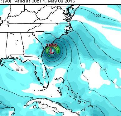
0Z Euro

0Z GFS

6Z GFS

For fun, the 0Z Canadian. Just a bit overboard IMO.

0Z GFS
6Z GFS
For fun, the 0Z Canadian. Just a bit overboard IMO.
0 likes
M a r k
- - - - -
Join us in chat: Storm2K Chatroom Invite. Android and IOS apps also available.
The posts in this forum are NOT official forecasts and should not be used as such. Posts are NOT endorsed by any professional institution or STORM2K.org. For official information and forecasts, please refer to NHC and NWS products.
- - - - -
Join us in chat: Storm2K Chatroom Invite. Android and IOS apps also available.
The posts in this forum are NOT official forecasts and should not be used as such. Posts are NOT endorsed by any professional institution or STORM2K.org. For official information and forecasts, please refer to NHC and NWS products.
-
gatorcane

- S2K Supporter

- Posts: 23708
- Age: 48
- Joined: Sun Mar 13, 2005 3:54 pm
- Location: Boca Raton, FL
First VIS loop, looks like a good spin near the Isle of Youth south of Cuba that is mostly void of convection at the moment with most of the convection on the right side. In fact 850MB vorticity chart confirms:


Last edited by gatorcane on Mon May 04, 2015 7:59 am, edited 2 times in total.
0 likes
Re: Potential Development off the Southeast U.S. Coastline
This is probably the strongest the latest GFS forecasts this potential system to be.
http://www.tropicaltidbits.com/analysis ... s=0&ypos=1
http://www.tropicaltidbits.com/analysis ... s=0&ypos=1

0 likes
-
tolakram
- Admin
- Posts: 20186
- Age: 62
- Joined: Sun Aug 27, 2006 8:23 pm
- Location: Florence, KY (name is Mark)
Re: Potential Development off the Southeast U.S. Coastline
0 likes
M a r k
- - - - -
Join us in chat: Storm2K Chatroom Invite. Android and IOS apps also available.
The posts in this forum are NOT official forecasts and should not be used as such. Posts are NOT endorsed by any professional institution or STORM2K.org. For official information and forecasts, please refer to NHC and NWS products.
- - - - -
Join us in chat: Storm2K Chatroom Invite. Android and IOS apps also available.
The posts in this forum are NOT official forecasts and should not be used as such. Posts are NOT endorsed by any professional institution or STORM2K.org. For official information and forecasts, please refer to NHC and NWS products.
-
TropicalAnalystwx13
- Category 5
- Posts: 2109
- Age: 28
- Joined: Tue Jul 19, 2011 8:20 pm
- Location: Wilmington, NC
- Contact:
SPECIAL TROPICAL WEATHER OUTLOOK
NWS NATIONAL HURRICANE CENTER MIAMI FL
1000 AM EDT MON MAY 4 2015
For the North Atlantic...Caribbean Sea and the Gulf of Mexico:
A non-tropical area of low pressure is expected to form near the
northwestern Bahamas around midweek. This system could gradually
acquire some subtropical characteristics by Thursday or Friday as it
moves generally northward at a slow forward speed. The next Special
Tropical Weather Outlook will be issued on this system by 11 AM EDT
Tuesday.
* Formation chance through 48 hours...low...near 0 percent
* Formation chance through 5 days...low...30 percent
$$
Forecaster Kimberlain
0 likes
-
TheAustinMan
- Category 5
- Posts: 1060
- Joined: Mon Jul 08, 2013 4:26 pm
- Location: Central TX / United States
Re: Potential Development off the Southeast U.S. Coastline
NDG wrote:This is probably the strongest the latest GFS forecasts this potential system to be.
http://www.tropicaltidbits.com/analysis ... s=0&ypos=1
http://s20.photobucket.com/user/ndgarcia/media/A123141A-DFCA-4793-AE55-ADB4A1FB6931.png_zpsvvqzdkdo.jpeg.html
The interesting thing about that GFS model run is that it brings the storm to a landfall in the Savannah, Georgia area.
0 likes
Treat my opinions with a grain of salt. For official information see your local weather service.
“It's tough to make predictions, especially about the future.”
“It's tough to make predictions, especially about the future.”
Who is online
Users browsing this forum: No registered users and 197 guests