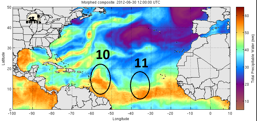
Aric Dunn wrote:holy impressive wave that just came off affrica.
TAFB didn't introduced that one at 12z Surface Analysis,but did with new wave around 35W.
Moderator: S2k Moderators


Aric Dunn wrote:holy impressive wave that just came off affrica.

cycloneye wrote:Aric,the predict team will start to hunt waves in the comming days so for sure we will see more information about the waves well before NHC introduce them.
http://www.met.nps.edu/~mtmontgo/storms2012.html
Aric Dunn wrote:cycloneye wrote:Aric,the predict team will start to hunt waves in the comming days so for sure we will see more information about the waves well before NHC introduce them.
http://www.met.nps.edu/~mtmontgo/storms2012.html
look at it. something you would see in august or sep not june. very good mid level circ and convection somewhat maintaining.
run six images.
http://oiswww.eumetsat.org/IPPS/html/MS ... /index.htm


000
ABNT20 KNHC 041734
TWOAT
TROPICAL WEATHER OUTLOOK
NWS NATIONAL HURRICANE CENTER MIAMI FL
200 PM EDT WED JUL 4 2012
FOR THE NORTH ATLANTIC...CARIBBEAN SEA AND THE GULF OF MEXICO...
A TROPICAL WAVE LOCATED OVER THE EXTREME NORTHEASTERN CARIBBEAN
SEA AND THE NORTHERN LEEWARD ISLANDS IS PRODUCING SCATTERED SHOWERS
AND A FEW STRONG THUNDERSTORMS ACROSS THE CENTRAL AND NORTHERN
LESSER ANTILLES...THE VIRGIN ISLANDS...AND PUERTO RICO...AND OVER
ADJACENT WATERS. A WIND GUST TO 46 MPH WAS REPORTED EARLIER TODAY
IN A BRIEF SQUALL AT ST. CROIX. GUSTY WINDS IN EXCESS OF 35 MPH AND
LOCALLY HEAVY RAINFALL WILL ACCOMPANY SOME OF THE STRONGER SQUALLS
THIS AFTERNOON AND EVENING. THIS SYSTEM HAS A LOW CHANCE...NEAR 0
PERCENT...OF BECOMING A TROPICAL CYCLONE DURING THE NEXT 48 HOURS
AS IT MOVES WESTWARD AT 20 TO 25 MPH.
ELSEWHERE...TROPICAL CYCLONE FORMATION IS NOT EXPECTED DURING THE
NEXT 48 HOURS.
$$
FORECASTER STEWART/KIMBERLAIN
Fego wrote:Finally we are receiving a good portion of rain with some squalls from a tropical wave that has 0 %, according with the latest TWO.000
ABNT20 KNHC 041734
TWOAT
TROPICAL WEATHER OUTLOOK
NWS NATIONAL HURRICANE CENTER MIAMI FL
200 PM EDT WED JUL 4 2012
FOR THE NORTH ATLANTIC...CARIBBEAN SEA AND THE GULF OF MEXICO...
A TROPICAL WAVE LOCATED OVER THE EXTREME NORTHEASTERN CARIBBEAN
SEA AND THE NORTHERN LEEWARD ISLANDS IS PRODUCING SCATTERED SHOWERS
AND A FEW STRONG THUNDERSTORMS ACROSS THE CENTRAL AND NORTHERN
LESSER ANTILLES...THE VIRGIN ISLANDS...AND PUERTO RICO...AND OVER
ADJACENT WATERS. A WIND GUST TO 46 MPH WAS REPORTED EARLIER TODAY
IN A BRIEF SQUALL AT ST. CROIX. GUSTY WINDS IN EXCESS OF 35 MPH AND
LOCALLY HEAVY RAINFALL WILL ACCOMPANY SOME OF THE STRONGER SQUALLS
THIS AFTERNOON AND EVENING. THIS SYSTEM HAS A LOW CHANCE...NEAR 0
PERCENT...OF BECOMING A TROPICAL CYCLONE DURING THE NEXT 48 HOURS
AS IT MOVES WESTWARD AT 20 TO 25 MPH.
ELSEWHERE...TROPICAL CYCLONE FORMATION IS NOT EXPECTED DURING THE
NEXT 48 HOURS.
$$
FORECASTER STEWART/KIMBERLAIN
NDG wrote:This Tropical Wave (#12) will pay a visit to FL over the weekend, as shown by the models.
Aric Dunn wrote:very interesting rotation associated with the tropical wave south of Hispaniola this morning that shot out of the convection. its speeding along but like many systems should slow in the western carrib and shear is high but drops some in the western carrib.... just something to watch.

Users browsing this forum: cycloneye, hurricanes1234 and 155 guests